
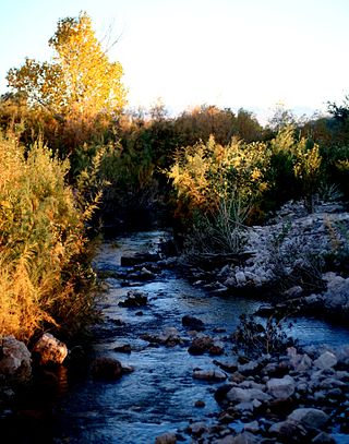
The Mojave River is an intermittent river in the eastern San Bernardino Mountains and the Mojave Desert in San Bernardino County, California, United States. Most of its flow is underground, while its surface channels remain dry most of the time, except for the headwaters and several bedrock gorges in the lower reaches.
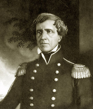
Stephen Watts Kearny was one of the foremost antebellum frontier officers of the United States Army. He is remembered for his significant contributions in the Mexican–American War, especially the Conquest of California. The Kearny Code, proclaimed on September 22, 1846, in Santa Fe, established the law and government of the newly acquired territory of New Mexico and was named after him. His nephew was Major General Philip Kearny of American Civil War fame.

Fort Irwin National Training Center is a major training area for the United States military in the Mojave Desert in northern San Bernardino County, California. Fort Irwin is at an average elevation of 2,454 feet (748 m). It is located 37 miles (60 km) northeast of Barstow, in the Calico Mountains.

The Battle of San Pasqual, also spelled San Pascual, was a military encounter that occurred during the Mexican–American War in what is now the San Pasqual Valley community of the city of San Diego, California. The series of military skirmishes ended with both sides claiming victory, and the victor of the battle is still debated. On December 6 and 7, 1846, General Stephen W. Kearny's US Army of the West, along with a small detachment of the California Battalion led by Archibald H. Gillespie, engaged a small contingent of Californios and their Presidial Lancers Los Galgos, led by Major Andrés Pico. After U.S. reinforcements arrived, Kearny's troops were able to reach San Diego.
The Muddy River, formerly known as the Moapa River, is a short river located in Clark County, in southern Nevada, United States. It is in the Mojave Desert, approximately 60 miles (97 km) north of Las Vegas.

Old Las Vegas Mormon Fort State Historic Park is a state park of Nevada. It contains the Old Mormon Fort, the first permanent structure built in what would become Las Vegas fifty years later. In present-day Las Vegas, the site is at the southeast corner of Las Vegas Boulevard and Washington Avenue, less than one mile north of the downtown area and Fremont Street. This is the only U.S. state park located in a city that houses the first building ever built in that city. The fort was listed on the National Register of Historic Places on February 1, 1972. The site is memorialized with a tablet erected by the Church of Jesus Christ of Latter-day Saints in 1997, along with Nevada Historical Marker #35, and two markers placed by the Daughters of Utah Pioneers.

Fort Tejon in California is a former United States Army outpost which was intermittently active from June 24, 1854, until September 11, 1864. It is located in the Grapevine Canyon between the San Emigdio Mountains and Tehachapi Mountains. It is in the area of the Tejon Pass along Interstate 5 in Kern County, California, the main route through the mountain ranges separating the Central Valley from the Los Angeles Basin and Southern California. The fort's location protected the San Joaquin Valley from the south and west.

The Old Spanish Trail is a historical trade route that connected the northern New Mexico settlements of Santa Fe, New Mexico with those of Los Angeles, California and southern California. Approximately 700 mi (1,100 km) long, the trail ran through areas of high mountains, arid deserts, and deep canyons. It is considered one of the most arduous of all trade routes ever established in the United States. Explored, in part, by Spanish explorers as early as the late 16th century, the trail was extensively used by traders with pack trains from about 1830 until the mid-1850s. The area was part of Mexico from Mexican independence in 1821 to the Mexican Cession to the United States in 1848.
The Paiute War, also known as the Pyramid Lake War, Washoe Indian War and the Pah Ute War, was an armed conflict between Northern Paiutes allied with the Shoshone and the Bannock against settlers from the United States, supported by military forces. It took place in May 1860 in the vicinity of Pyramid Lake in the Utah Territory, now in the northwest corner of present-day Nevada. The war was preceded by a series of increasingly violent incidents, culminating in two pitched battles in which 79 Whites and 25 Indigenous people were killed. Smaller raids and skirmishes continued until a cease-fire was agreed to in August 1860; there was no treaty.

The Mojave Road, also known as Old Government Road, is a historic route and present day dirt road across what is now the Mojave National Preserve in the Mojave Desert in the United States. This rough road stretched 147 miles (237 km) from Beale's Crossing, to Fork of the Road location along the north bank of the Mojave River where the old Mojave Road split off from the route of the Old Spanish Trail/Mormon Road.
The pursuit of the perpetrators of the Mountain Meadows massacre, which atrocity occurred September 11, 1857, had to await the conclusion of the American Civil War to begin in earnest.

The District of Southern California was a 19th-century district of Department of the Pacific, a command of the United States Army.
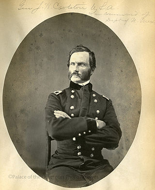
James Henry Carleton was an officer in the US Army and a Union general during the American Civil War. Carleton is best known as an Indian fighter in the Southwestern United States.
The California Indian Wars were a series of wars, battles, and massacres between the United States Army, and the Indigenous peoples of California. The wars lasted from 1850, immediately after Alta California, acquired during the Mexican–American War, became the state of California, to 1880 when the last minor military operation on the Colorado River ended the Calloway Affair of 1880.

Camp Cady was a U.S. Army Camp, on the Mojave Road near the Mojave River in the Mojave Desert, located about 20 miles east of modern-day Barstow, California, in San Bernardino County, at an elevation of 1690 feet. Camp Cady was named after Major Albemarle Cady, 6th Infantry Regiment, who was a friend of Carleton and commander at Fort Yuma in 1860.
Bitter Spring is a spring within the Fort Irwin National Training Center in San Bernardino County, California. It lies at an elevation of 1355 feet and is located in a valley between the Soda Mountains to the east, the Tiefort Mountains to the northwest, Alvord Mountain to the southwest and Cronese Mountains to the south and southeast.
Mormon Road, also known to the 49ers as the Southern Route, of the California Trail in the Western United States, was a seasonal wagon road pioneered by a Mormon party from Salt Lake City, Utah led by Jefferson Hunt, that followed the route of Spanish explorers and the Old Spanish Trail across southwestern Utah, northwestern Arizona, southern Nevada and the Mojave Desert of California to Los Angeles in 1847. From 1855, it became a military and commercial wagon route between California and Utah, called the Los Angeles – Salt Lake Road. In later decades this route was variously called the "Old Mormon Road", the "Old Southern Road", or the "Immigrant Road" in California. In Utah, Arizona and Nevada it was known as the "California Road".
Fort Piute, originally named Fort Beale, was a post first established by Captain James H. Carleton, of the 1st Dragoons. Fort Piute lies at the elevation 2,828 feet / 862 meters near the place where the surface flow of Piute Creek ends, after running down stream from Piute Spring creating an oasis. Where the surface flow of the creek ends it descends into the soil of the wash of Piute Creek that then turns to run to the southwest towards the Colorado River.

The Mojave Road Los Angeles was designated a California Historic Landmark on March 19, 1985. It runs from Drum Barracks in Los Angeles County to the Colorado River in San Bernardino County, California.
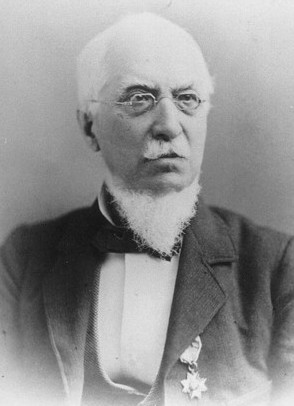
Albemarle Cady was a career United States Army officer who served in the Second Seminole War, Mexican–American War, First Sioux War and the American Civil War. During the Civil War, he was briefly lieutenant colonel of the 7th Infantry Regiment. He then served in administrative positions in the Department of the Pacific, including the District of Oregon. He received brevet appointments for his service in the Mexican–American War and the Civil War. He retired from the Regular Army as a colonel on May 18, 1864. On July 17, 1866, President Andrew Johnson nominated and on July 26, 1866, the United States Senate confirmed the appointment of Cady as a brevet brigadier general in the Regular Army, to rank from March 13, 1865.