Yungay province

Last updated
Yungay
Beauty of mount Huandoy, Cordillera Blanca, Ancash, Peru.jpg
The mountain Tullparahu as seen from Yungay
Bandera de Yungay.svg
Escudo Yungay.svg
Location of the province Yungay Ancash.PNG
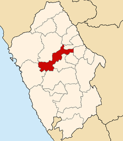
Location of Yungay in the Ancash Region
Country Peru
Region Ancash
FoundedOctober 28, 1904
Capital Yungay
Government
  MayorFernando Ciro Casio Consolación
(2019-2022)
Area
  Total
1,361.48 km2 (525.67 sq mi)
Elevation
2,458 m (8,064 ft)
Population
  Total
50,841
  Density37/km2 (97/sq mi)
UBIGEO 0220
Website www.yungayperu.com.pe

Yungay is one of twenty provinces of the Ancash Region in Peru. [1]

Contents

Geography

The Cordillera Blanca and the Cordillera Negra traverse the province. Waskaran, the highest elevation of Peru, lies on the border with the province of Carhuaz. Chakrarahu, Chopicalqui, Tullparahu and Yanarahu (Ruriqucha) belong to the highest peaks of the province. Other mountains are listed below: [2]

Political division

Yungay is divided into eight districts, which are:

Ethnic groups

The people in the province are mainly indigenous citizens of Quechua descent. Quechua is the language which the majority of the population (73.19%) learnt to speak in childhood, 26.48% of the residents started speaking using the Spanish language (2007 Peru Census). [3]

See also

References

  1. (in Spanish) www.yungayperu.com.pe
  2. escale.minedu.gob.pe - UGEL map of the province of Yungay (Ancash Region)
  3. inei.gob.pe Archived January 27, 2013, at the Wayback Machine INEI, Peru, Censos Nacionales 2007

(in Spanish) www.yungayperu.com.pe

9°08′22″S77°44′42″W / 9.13944°S 77.74500°W / -9.13944; -77.74500