Z Bend

Last updated
View of Murchison River Gorge from the Z Bend lookout. Z Bend.jpg
View of Murchison River Gorge from the Z Bend lookout.

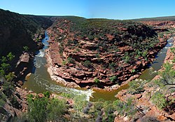
The Z Bend lookout is a popular tourist lookout on the Murchison River Gorge in Western Australia. It is located at 27°39′19″S114°27′19″E / 27.65528°S 114.45528°E / -27.65528; 114.45528 Coordinates: 27°39′19″S114°27′19″E / 27.65528°S 114.45528°E / -27.65528; 114.45528 , [1] [2] about 30 kilometres (19 mi) east of Kalbarri, in the Kalbarri National Park. One of four lookouts in the national park, it is situated on a sharp bend in the gorge. The view includes an excellent section through the Tumblagooda Sandstone, a geological sequence of fluvial and coastal deposits over one kilometre (0.62 mi) deep. [3]

Facilities

Picnic seating and toilets are situated next to the car park. From the car park there is a walk of about 500 metres (1,600 ft) to the gorge lookout. There is then a climb of about 50 metres (160 ft) to the bed of the Murchison River. [3]

Related Research Articles

Kanangra-Boyd National Park Protected area in New South Wales, Australia

The Kanangra-Boyd National Park is a protected national park that is located in the Central Tablelands region, west of the Southern Highlands and Macarthur regions, in New South Wales, in eastern Australia. The 68,660-hectare (169,700-acre) national park is situated approximately 180 kilometres (110 mi) south-west of Sydney and is contiguous with the Blue Mountains National Park and the Nattai National Park. The park was established in 1969.

Oxley Wild Rivers National Park Protected area in New South Wales, Australia

The Oxley Wild Rivers National Park is a protected national park that is located in the Northern Tablelands region of New South Wales, Australia in the Port Macquarie-Hastings City Council and Walcha Shire councils. The 145,223-hectare (358,850-acre) park is situated 445 kilometres (277 mi) north of Sydney and is named in memory of the Australian explorer John Oxley, who passed through the area in 1818 and is one of the largest national parks in New South Wales.

Danggu Gorge National Park Protected area in Western Australia

Danggu (Geikie) Gorge National Park is a national park in the Kimberley region of Western Australia, 1,837 kilometres (1,141 mi) northeast of Perth and approximately 420 km (261 mi) east of Broome by road. The gorge was originally named in honour of Sir Archibald Geikie, the Director General of Geological Survey for Great Britain and Ireland when it was given its European name in 1883. Sir Archibald never visited the gorge and the National Park is progressively being officially changed to the Bunuba traditional owners name of Danggu. It is part of the Balili Conservation Park.

Kalbarri National Park Protected area in Western Australia

Kalbarri National Park is located 485 km (301 mi) north of Perth, in the Mid West region of Western Australia.

Wollomombi Falls

The Wollomombi Falls is a plunge waterfall on the Wollomombi River in the New England region of New South Wales, Australia.

Buller Gorge

The Buller Gorge is a gorge located in the northwest of the South Island of New Zealand. The Buller River flows through the deep canyon between Murchison and Westport. Land Information New Zealand lists two sections for the gorge, Upper Buller Gorge and Lower Buller Gorge. State Highway 6 runs alongside, but considerably above, the river through the gorge. The Stillwater - Westport Line railway also runs through the gorge.

Murchison River (Western Australia)

The Murchison River is the second longest river in Western Australia. It flows for about 820 km (510 mi) from the southern edge of the Robinson Ranges to the Indian Ocean at Kalbarri. The Murchison-Yalgar-Hope river system is the longest river system in Western Australia. It has a mean annual flow of 208 gigalitres, although in 2006, the peak year on record since 1967, flow was 1,806 gigalitres.

Hamersley Range Mountain range in the Pilbara region of Western Australia

The Hamersley Range is a mountainous region of the Pilbara region of Western Australia. The range was named on 12 June 1861 by explorer Francis Thomas Gregory after Edward Hamersley, a prominent promoter of his exploration expedition to the northwest. Juukan Gorge lies within the ranges, about 60 kilometres (37 mi) from the mining town of Tom Price, as does Karijini National Park.

Kalbarri, Western Australia Town in Western Australia

Kalbarri is a coastal town in the Mid West region located 592 km (368 mi) north of Perth, Western Australia. The town is found at the mouth of the Murchison River and has an elevation of 6 metres (20 ft). It is connected by public transport to Perth via Transwa coach services N1 and N2.

Blencoe Falls

The Blencoe Falls is a segmented waterfall on the Blencoe Creek, located in the Far North region of Queensland, Australia.

Apsley Falls

The Apsley Falls are two waterfalls on the Apsley River in the Northern Tablelands region of New South Wales, Australia. The falls are located about 20 kilometres (12 mi) east of Walcha, and 1 kilometre off the Oxley Highway in a deep gorge, that is part of the Oxley Wild Rivers National Park. They are the first falls in a succession of dramatic drops in an area that has some of the most remarkable scenery in Eastern Australia. The first drop of the falls is about 65 metres (213 ft) in depth, and the second, which is about 800 metres (2,625 ft) further on, plummets 58 metres (190 ft) to the bottom of the gorge.

Tumblagooda Sandstone

The Tumblagooda Sandstone is a geological formation deposited during the Silurian or Ordovician periods, between four and five hundred million years ago, and is now exposed on the west coast of Australia in river and coastal gorges near the tourist town of Kalbarri, Kalbarri National Park and the Murchison River gorge, straddling the boundary of the Carnarvon and Perth basins. Visible trackways are interpreted by some to be the earliest evidence of fully terrestrial animals.

Gold Coast hinterland

The Gold Coast hinterland is an area of South East Queensland, Australia that comprises the Tweed Range, Nimmel Range, Tamborine Mountain, Numinbah Valley, eastern parts of the McPherson Range and western parts of suburban Gold Coast, such as Mudgeeraba. This undefined unit of area is known for its tourist attractions including resorts, rainforest, lookouts, national parks, its diversity of fauna and flora and as a green backdrop to the coastal strip. It overlaps part of the Scenic Rim and is part of both the City of Gold Coast and Scenic Rim Region and includes Springbrook, Binna Burra and O'Reilly.

Shell House is an area of coastal cliffs located between Red Bluff and Bluff Point in Kalbarri National Park in Mid West Western Australia. They are highly regarded for their scenery, and also for the exposures of geological strata, which include Ordovician Tumblagooda sandstone, Triassic Wittecarra sandstone and Kockatea shale. The Shell House cliffs have been listed on Australia's Register of the National Estate since 1978.

Murchison River Gorge

Murchison River Gorge is a riverine gorge in Mid West Western Australia. Carved by the meandering lower reaches of the Murchison River, it is more than 80 kilometres (50 mi) long, and up to 129 metres (423 ft) deep. It begins about 13.5 kilometres (8.4 mi) north-northwest of Ajana, and extends to the mouth of the river at Kalbarri.

Stone Wall is an escarpment overlooking the Murchison River Gorge about 16 kilometres (9.9 mi) north-east of Kalbarri in Mid West Western Australia. It is of geological interest because it provides outstanding exposures of five Cretaceous formations unconformably overlying the Ordovician Tumblagooda sandstone. The Cretaceous formations contain trace fossils of Skolithos and Cylindricum. It has been visited on geological excursions and is considered an important research site.

Pakuba Place in Northern Uganda, Uganda

Pakuba is a location in Northern Uganda.

Melaleuca lara is a plant in the myrtle family, Myrtaceae and is endemic to a small area on the west coast of Western Australia. It is similar to Melaleuca ciliosa with its hairy young leaves and heads of yellow flowers ageing to red but there are fewer flowers in each head and the leaves are generally smaller.

The Georges Creek, a perennial stream that is part of the Macleay River catchment, is located in the Northern Tablelands and Mid North Coast regions of New South Wales, Australia.

Murchison House Station

Murchison House Station is a pastoral lease that once operated as a sheep station but now rears cattle and goats in Western Australia.

References

  1. Gazetteer of Australia (1996). Belconnen, ACT: Australian Surveying and Land Information Group.
  2. "Z Bend". Gazetteer of Australia online. Geoscience Australia, Australian Government.
  3. 1 2 Mory, A. J.; Hocking, R. M. (2008). "Geology of the Kalbarri and Mingenew areas — A field guide". Geological Survey of Western Australia Record 2008/11. Department of Industry and Resources, Government of Western Australia. Retrieved 2008-01-23.Cite journal requires |journal= (help)