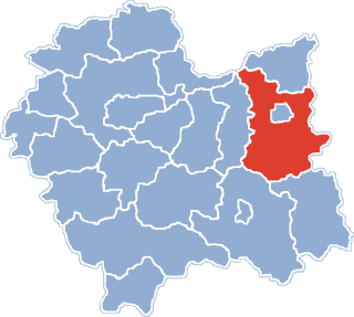
Gmina Skrzyszów is a rural gmina in Tarnów County, Lesser Poland Voivodeship, in southern Poland. Its seat is the village of Skrzyszów, which lies approximately 7 kilometres (4 mi) south-east of Tarnów and 81 km (50 mi) east of the regional capital Kraków.

Pławna is a village in the administrative district of Gmina Ciężkowice, within Tarnów County, Lesser Poland Voivodeship, in southern Poland. It lies approximately 7 kilometres (4 mi) south-west of Ciężkowice, 32 km (20 mi) south of Tarnów, and 80 km (50 mi) south-east of the regional capital Kraków.
Zalasowa is a village in the administrative district of Gmina Ryglice, within Tarnów County, Lesser Poland Voivodeship, in southern Poland. It lies approximately 6 kilometres (4 mi) north of Ryglice, 15 km (9 mi) south-east of Tarnów, and 87 km (54 mi) east of the regional capital Kraków.
Burzyn is a village in the administrative district of Gmina Tuchów, within Tarnów County, Lesser Poland Voivodeship, in southern Poland. It lies approximately 4 kilometres (2 mi) south of Tuchów, 20 km (12 mi) south of Tarnów, and 84 km (52 mi) east of the regional capital Kraków.
Dąbrówka Tuchowska is a village in the administrative district of Gmina Tuchów, within Tarnów County, Lesser Poland Voivodeship, in southern Poland. It lies approximately 4 kilometres (2 mi) south of Tuchów, 19 km (12 mi) south of Tarnów, and 83 km (52 mi) east of the regional capital Kraków.
Jodłówka Tuchowska is a village in the administrative district of Gmina Tuchów, within Tarnów County, Lesser Poland Voivodeship, in southern Poland. It lies approximately 10 kilometres (6 mi) south of Tuchów, 25 km (16 mi) south of Tarnów, and 87 km (54 mi) east of the regional capital Kraków.
Karwodrza is a village in the administrative district of Gmina Tuchów, within Tarnów County, Lesser Poland Voivodeship, in southern Poland. It lies approximately 3 kilometres (2 mi) north-east of Tuchów, 14 km (9 mi) south of Tarnów, and 83 km (52 mi) east of the regional capital Kraków.
Łowczów is a village in the administrative district of Gmina Tuchów, within Tarnów County, Lesser Poland Voivodeship, in southern Poland. It lies approximately 5 kilometres (3 mi) north-west of Tuchów, 13 km (8 mi) south of Tarnów, and 78 km (48 mi) east of the regional capital Kraków.
Lubaszowa is a village in the administrative district of Gmina Tuchów, within Tarnów County, Lesser Poland Voivodeship, in southern Poland. It lies approximately 4 kilometres (2 mi) south of Tuchów, 19 km (12 mi) south of Tarnów, and 82 km (51 mi) east of the regional capital Kraków.
Meszna Opacka is a village in the administrative district of Gmina Tuchów, within Tarnów County, Lesser Poland Voivodeship, in southern Poland. It lies approximately 5 kilometres (3 mi) west of Tuchów, 16 km (10 mi) south of Tarnów, and 78 km (48 mi) east of the regional capital Kraków.
Piotrkowice is a village in the administrative district of Gmina Tuchów, within Tarnów County, Lesser Poland Voivodeship, in southern Poland. It lies approximately 5 kilometres (3 mi) north-west of Tuchów, 13 km (8 mi) south of Tarnów, and 78 km (48 mi) east of the regional capital Kraków.
Siedliska is a village in the administrative district of Gmina Tuchów, within Tarnów County, Lesser Poland Voivodeship, in southern Poland. It lies approximately 6 kilometres (4 mi) south-west of Tuchów, 19 km (12 mi) south of Tarnów, and 80 km (50 mi) east of the regional capital Kraków.
Trzemeszna is a village in the administrative district of Gmina Tuchów, within Tarnów County, Lesser Poland Voivodeship, in southern Poland. It lies approximately 6 kilometres (4 mi) north of Tuchów, 11 km (7 mi) south-east of Tarnów, and 82 km (51 mi) east of the regional capital Kraków.
Isep is a village in the administrative district of Gmina Wojnicz, within Tarnów County, Lesser Poland Voivodeship, in southern Poland. It lies approximately 4 kilometres (2 mi) south of Wojnicz, 16 km (10 mi) south-west of Tarnów, and 67 km (42 mi) east of the regional capital Kraków.
Więckowice is a village in the administrative district of Gmina Wojnicz, within Tarnów County, Lesser Poland Voivodeship, in southern Poland. It lies approximately 4 kilometres (2 mi) south of Wojnicz, 18 km (11 mi) south-west of Tarnów, and 65 km (40 mi) east of the regional capital Kraków.
Wielka Wieś is a village in the administrative district of Gmina Wojnicz, within Tarnów County, Lesser Poland Voivodeship, in southern Poland. It lies approximately 4 kilometres (2 mi) south of Wojnicz, 18 km (11 mi) south-west of Tarnów, and 65 km (40 mi) east of the regional capital Kraków.
Bobrowniki Wielkie is a village in the administrative district of Gmina Żabno, within Tarnów County, Lesser Poland Voivodeship, in southern Poland. It lies approximately 8 kilometres (5 mi) south of Żabno, 8 km (5 mi) north-west of Tarnów, and 70 km (43 mi) east of the regional capital Kraków.
Sieradza is a village in the administrative district of Gmina Żabno, within Tarnów County, Lesser Poland Voivodeship, in southern Poland. It lies approximately 4 kilometres (2 mi) south-east of Żabno, 11 km (7 mi) north-west of Tarnów, and 72 km (45 mi) east of the regional capital Kraków.