
Czernichów is a village in Kraków County, Lesser Poland Voivodeship, in southern Poland. It is the seat of the gmina called Gmina Czernichów. It lies approximately 21 km (13 mi) south-west of the regional capital Kraków.
Gmina Liszki is a rural gmina in Kraków County, Lesser Poland Voivodeship, in southern Poland. Its seat is the village of Liszki, which lies approximately 13 kilometres (8 mi) west of the regional capital Kraków.
Gmina Skawina is an urban-rural gmina in Kraków County, Lesser Poland Voivodeship, in southern Poland. Its seat is the town of Skawina, which lies approximately 12 kilometres (7 mi) south-west of the regional capital Kraków.
Wokowice is a village in the administrative district of Gmina Brzesko, within Brzesko County, Lesser Poland Voivodeship, in southern Poland. It lies approximately 8 kilometres (5 mi) north-east of Brzesko and 55 km (34 mi) east of the regional capital Kraków.
Bednarze is a village in the administrative district of Gmina Czernichów, within Kraków County, Lesser Poland Voivodeship, in southern Poland. It lies approximately 8 kilometres (5 mi) north of Czernichów and 22 km (14 mi) west of the regional capital Kraków.
Czułówek is a village in the administrative district of Gmina Czernichów, within Kraków County, Lesser Poland Voivodeship, in southern Poland. It lies approximately 7 kilometres (4 mi) north of Czernichów and 19 km (12 mi) west of the regional capital Kraków.
Dąbrowa Szlachecka is a village in the administrative district of Gmina Czernichów, within Kraków County, Lesser Poland Voivodeship, in southern Poland. It lies approximately 7 kilometres (4 mi) east of Czernichów and 15 km (9 mi) south-west of the regional capital Kraków.
Kamień is a village in the administrative district of Gmina Czernichów, within Kraków County, Lesser Poland Voivodeship, in southern Poland. It lies approximately 7 kilometres (4 mi) north-west of Czernichów and 26 km (16 mi) west of the regional capital Kraków.
Kłokoczyn is a village in the administrative district of Gmina Czernichów, within Kraków County, Lesser Poland Voivodeship, in southern Poland. It lies approximately 3 kilometres (2 mi) west of Czernichów and 23 km (14 mi) west of the regional capital Kraków.
Nowa Wieś Szlachecka is a village in the administrative district of Gmina Czernichów, within Kraków County, Lesser Poland Voivodeship, in southern Poland. It lies approximately 5 kilometres (3 mi) north of Czernichów and 18 km (11 mi) west of the regional capital Kraków.
Przeginia Duchowna is a village in the administrative district of Gmina Czernichów, within Kraków County, Lesser Poland Voivodeship, in southern Poland. It lies approximately 4 kilometres (2 mi) north-west of Czernichów and 22 km (14 mi) west of the regional capital Kraków.
Przeginia Narodowa is a village in the administrative district of Gmina Czernichów, within Kraków County, Lesser Poland Voivodeship, in southern Poland. It lies approximately 4 kilometres (2 mi) north-west of Czernichów and 22 km (14 mi) west of the regional capital Kraków.
Ratanice is a village in the administrative district of Gmina Czernichów, within Kraków County, Lesser Poland Voivodeship, in southern Poland. It lies approximately 2 kilometres (1 mi) north-west of Czernichów and 22 km (14 mi) west of the regional capital Kraków.
Rusocice is a village in the administrative district of Gmina Czernichów, within Kraków County, Lesser Poland Voivodeship, in southern Poland. It lies approximately 5 kilometres (3 mi) west of Czernichów and 24 km (15 mi) west of the regional capital Kraków.

Rybna is a village in the administrative district of Gmina Czernichów, within Kraków County, Lesser Poland Voivodeship, in southern Poland. It lies approximately 8 kilometres (5 mi) north of Czernichów and 21 km (13 mi) west of the regional capital Kraków.
Wołowice is a village in the administrative district of Gmina Czernichów, within Kraków County, Lesser Poland Voivodeship, in southern Poland. It lies approximately 5 kilometres (3 mi) east of Czernichów and 18 km (11 mi) south-west of the regional capital Kraków.
Kidów is a village in the administrative district of Gmina Pilica, within Zawiercie County, Silesian Voivodeship, in southern Poland. It lies approximately 6 kilometres (4 mi) north-east of Pilica, 21 km (13 mi) east of Zawiercie, and 58 km (36 mi) north-east of the regional capital Katowice.
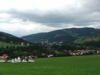
Międzybrodzie Żywieckie is a village in the administrative district of Gmina Czernichów, within Żywiec County, Silesian Voivodeship, in southern Poland. It lies approximately 2 kilometres (1 mi) north of Czernichów, 9 km (6 mi) north of Żywiec, and 56 km (35 mi) south of the regional capital Katowice.
Radostynia is a village in the administrative district of Gmina Biała, within Prudnik County, Opole Voivodeship, in south-western Poland. It lies approximately 4 kilometres (2 mi) north-east of Biała Prudnicka, 14 km (9 mi) north-east of Prudnik, and 32 km (20 mi) south-west of the regional capital Opole.


