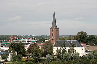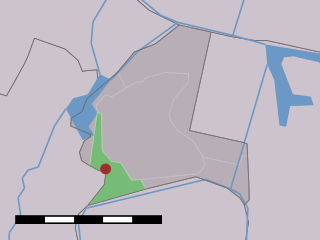
Gorssel is a village in the municipality of Lochem, province of Gelderland, Netherlands. It is located about 9 km southeast of the city centre of Deventer, Overijssel. In 2015, it had a population of 4,043.

Usquert is a village in the Dutch province of Groningen. It is located in the municipality of Het Hogeland. It had a population of around 1,415 in January 2017.

Mijdrecht is a town in the Netherlands with about 16,000 residents. It is located in the municipality of De Ronde Venen, about 7 kilometres (4.3 mi) west of the main A2 motorway, between Utrecht and Amsterdam.

Sloten is a village in the Dutch province of North Holland. It is a part of the municipality of Amsterdam, and lies about 6 km west of the city centre.
Abcoude-Proostdij is a former municipality in the Dutch province of Utrecht. Abcoude-Proostdij covered the northern part of the current municipality of Abcoude, including the village of Abcoude itself.
Houtrijk en Polanen is a former municipality in the Dutch province of North Holland. It existed from 1817 to 1863, when it was merged with Haarlemmerliede en Spaarnwoude.

Kalslagen en Bilderdam is a former municipality in the Dutch province of North Holland. It existed between 1817 and 1854, and was sometimes simply called Kalslagen.
Zuid- en Noord-Schermer is a former municipality in the Dutch province of North Holland. It existed until 1970, when it became a part of the municipality of Schermer.
Ambt Delden is a former municipality in the Dutch province of Overijssel. It consisted of the countryside surrounding the city of Delden, which was a separate municipality.

Steenwijkerwold is a village in the Dutch province of Overijssel. It is located in the municipality of Steenwijkerland, about 5 km northwest of Steenwijk. Steenwijkerwold was a separate municipality until 1973, when it became a part of Steenwijk.

Zwollerkerspel is a former municipality in the province of Overijssel, Netherlands. It covered the countryside around the city of Zwolle. Zwollerkerspel was a separate municipality from 1802 until August 1, 1967, when it became a part of Zwolle, Hasselt, Heino, IJsselmuiden and Genemuiden.
Keppel is a former municipality in the Dutch province of Gelderland, consisting of the villages of Laag-Keppel and Hoog-Keppel. It existed until 1818, when it merged with Hummelo to form the new municipality of Hummelo en Keppel.
Broek was a municipality in the Dutch province of South Holland, located west and north of Gouda. A longer name of the municipality, Broek, Bloemendaal, Broekhuizen, Thuil en het Weegje names the polders that are part of the municipality.
Hofwegen is a hamlet in Molenlanden, which is a municipality in the Dutch province of South Holland. It is located on the south bank of the small river Graafstroom. It is now considered to be part of the village of Bleskensgraaf, which lies on the opposite bank.

Hoog en Woud Harnasch is a former municipality in the Dutch province of South Holland. It was located to the west of the city of Delft.
Kethel en Spaland is a former municipality in the Dutch province of South Holland. It was located to the north of the city of Schiedam, and covered the village of Kethel and the hamlet Kandelaar.

Zalk is a village on the west bank of the river IJssel within the municipality of Kampen in the Dutch province of Overijssel. It is situated just behind the winter dike of the IJssel river across from Wilsum.
Tempel, also known as De Tempel, is a former municipality and former manorial estate in the Dutch province of South Holland. It was located about 3 km southwest of the center of the current village of Berkel en Rodenrijs.


