
Dragsfjärd is a former municipality of Finland. On January 1, 2009, it was consolidated with Kimito and Västanfjärd to form the new municipality of Kimitoön.

Farmanieh is a district located in Shemiran, Tehran, Iran centered on Farmanieh Street. Farmanieh neighborhood extends south all the way to Sadr Expressway, where it becomes Dibaji, and as far north as Niavaran Expressway. It has one of, if not the highest household income rates in Tehran, being home to many embassies, nobles and notables of Iran.
Het Sas is a small village in the municipality Alphen-Chaam in the Dutch province of North Brabant. It is located southwest of Alphen.
Ozyorskoye is a rural locality in Vyborgsky District of Leningrad Oblast, Russia, located on the Karelian Isthmus. Until the Winter War and Continuation War, it had been the administrative center of the Vuoksenranta Municipality of Viipuri Province, Finland.

Świniary is a village in the administrative district of Gmina Twardogóra, within Oleśnica County, Lower Silesian Voivodeship, in south-western Poland. Prior to 1945 it was in Germany.
Załęcze is a village in the administrative district of Gmina Rawicz, within Rawicz County, Greater Poland Voivodeship, in west-central Poland.
Ariany is a village in the administrative district of Gmina Waganiec, within Aleksandrów County, Kuyavian-Pomeranian Voivodeship, in north-central Poland. It lies 2 kilometres (1 mi) south of Waganiec, 13 km (8 mi) south-east of Aleksandrów Kujawski, and 31 km (19 mi) south-east of Toruń.
Stare Rudki is a village in the administrative district of Gmina Augustów, within Augustów County, Podlaskie Voivodeship, in north-eastern Poland. It lies approximately 11 kilometres (7 mi) west of Augustów and 87 km (54 mi) north of the regional capital Białystok.
Łazy is a village in the administrative district of Gmina Goniądz, within Mońki County, Podlaskie Voivodeship, in north-eastern Poland.
Jakubów is a village in the administrative district of Gmina Goszczyn, within Grójec County, Masovian Voivodeship, in east-central Poland. It lies approximately 5 kilometres (3 mi) north-west of Goszczyn, 13 km (8 mi) south of Grójec, and 53 km (33 mi) south of Warsaw.
Hacsamlı is a village in the Lachin Rayon of Azerbaijan.
Niedźwiady is a village in the administrative district of Gmina Żelazków, within Kalisz County, Greater Poland Voivodeship, in west-central Poland. It lies approximately 5 kilometres (3 mi) north of Kalisz and 105 km (65 mi) south-east of the regional capital Poznań.
Trzy Góry is a settlement in the administrative district of Gmina Ryczywół, within Oborniki County, Greater Poland Voivodeship, in west-central Poland. It lies approximately 5 kilometres (3 mi) east of Ryczywół, 18 km (11 mi) north of Oborniki, and 45 km (28 mi) north of the regional capital Poznań.
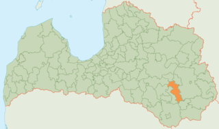
Riebiņi Municipality is a municipality in Latgale, Latvia. The municipality was formed in 2004 by merging Galēni parish, Riebiņi parish, Rušona parish, Silajāņi parish, Sīļukalns parish and Stabulnieki parish, the administrative centre being Riebiņi.
Gulou District is a district of the city of Kaifeng, Henan province, China.
Tounounga is a village and rural commune in Niger.
Gubyeongsan is a mountain of Chungcheongbuk-do, South Korea. It has an elevation of 876 metres.
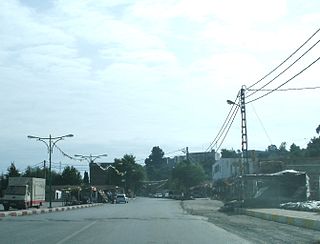
Deux Bassins is a town and commune in Médéa Province, Algeria. According to the 1998 census it has a population of 5,019.

The Co-Cathedral of St. Anthony of Padua also St. Anthony Latin Catholic Church of Mersin is a church in Mersin, Turkey. Is a Co-Cathedral of the Roman Catholic Vicariate Apostolic of Anatolia.

Església de Sant Serni de Nagol is a church located in Sant Julià de Lòria, Andorra. It is a heritage property registered in the Cultural Heritage of Andorra. It was built in the 11th century.


