The Black Forest is a large forested mountain range in the state of Baden-Württemberg in southwest Germany, bounded by the Rhine Valley to the west and south and close to the borders with France and Switzerland. It is the source of the Danube and Neckar rivers.

At 1,493 metres (4,898 ft) the Feldberg in the Black Forest is the highest mountain in Baden-Württemberg, and the highest in Germany outside of the Alps and Bavaria. The local municipality of Feldberg was named after the mountain.

The Acher is a 53.6-kilometre-long river and tributary of the Rhine in the county of Ortenau, in the south German state of Baden-Württemberg. It flows in a northwesterly direction from the Black Forest to the Rhine, between the two rivers Rench to the south and the Oos to the north.

Feldberg is a municipality in the district of Breisgau-Hochschwarzwald in Baden-Württemberg in southern Germany. It is located near the Feldberg, the highest summit in Baden-Württemberg. It comprises the settlements of Altglashütten, Neuglashütten, Falkau, Bärental, and Feldberg. At an elevation of 1,277 m, the last is considered the highest village in Germany.

The Windgfällweiher is a reservoir between the Titisee and the Schluchsee in the south of Baden-Württemberg, Germany. It is located within the High Black Forest and lies in a hollow formed by ice age glaciation between the villages of Altglashütten, Falkau and Aha on the territory of the municipality of Lenzkirch.

Belchen, 1,414 metres (4,639 ft), or Black Forest Belchen is the fourth-highest summit of the Black Forest, after Feldberg, Seebuck, and Herzogenhorn. The municipalities of Münstertal, Schönenberg and Kleines Wiesental meet on the summit dome of Belchen which is located in the southwest German state of Baden-Württemberg.

The Herzogenhorn is a mountain, 1,415.2 m above sea level (NHN), in the southwest German state of Baden-Württemberg. It lies within a nature reserve in the municipality of Bernau im Schwarzwald.
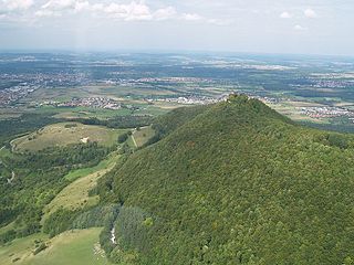
Teckberg is a mountain located in Landkreis Esslingen, Baden-Württemberg, Germany. It stands at an elevation of 775 m above sea level (NHN) (2,543 ft) and is crowned by the castle Teck.
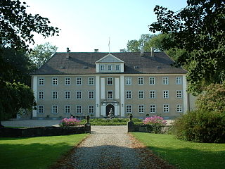
Achstetten Castle is a classicist mansion in the southern German municipality of Achstetten in Upper Swabia.

The High Black Forest is a touristic and geographical region in the south-west of the German federal state Baden-Württemberg, primarily in the Southern Black Forest.

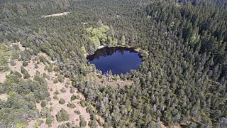
The Feldsee is a lake in southern Baden-Württemberg at the foot of the Feldberg east of Freiburg im Breisgau in Germany. It is part of the Southern Black Forest Nature Park.

Falkenstein Castle is a ruined hill castle near Freiburg im Breisgau on the territory of the present-day municipality Breitnau in the county of Breisgau-Hochschwarzwald in the German state of Baden-Württemberg. The castle site lies in a triangle formed by the entrance of the Höllental valley – the Lower Höllental and the Engenbach valley, not far from the Buchenbach village of Falkensteig, 617.6 m above sea level (NN) on a rocky crag that is very difficult to get to today. Of the castle itself only a few wall remains are left. It is one of the less well preserved ruins in the Breisgau.

The Hohloh is a mountain, 988.3 m above sea level (NHN), on the eastern main ridge of the Northern Black Forest in Germany. It lies near the village of Kaltenbronn in the borough of Gernsbach, a town in the county of Rastatt in the German state of Baden-Württemberg. Its summit is the highest point in the borough of Gernsbach and the eastern chain of the Northern Black Forest, the ridge between the rivers Murg and Enz. A mountain pass runs northeast of the summit plateau between the two river valleys passing over the saddle of Schwarzmiss.

The Nonnenmattweiher is a lake that has been impounded by an embankment in the Southern Black Forest in Germany. Together with the surrounding area it forms a nature reserve of the same name in the High Black Forest in the state of Baden-Württemberg.
The Blindensee is a raised bog lake on the territory of Schönwald im Schwarzwald in the Black Forest in Germany. It lies within the county of Schwarzwald-Baar-Kreis in the state of Baden-Württemberg. It is only accessible on a board walk and lies with raised bog area that has been designated as a nature reserved near the watershed between the rivers Gutach and Elz.

The Venus figurines of Petersfels are several small female statuettes from the Upper Paleolithic era, carved from jet lignite. The tallest figurine is called the Venus of Engen. The figurines were discovered in the Petersfels caves near Engen, Baden-Württemberg, excavated in 1927–1932 by Eduard Peters und Volker Toepfer and then in 1974–1976 and 1978 by Gerd Albrecht. They stand between 1.5 and 4 cm tall and are about 15,000 to 11,500 years old, created during the Magdalenian era. They are housed in the Museums of Freiburg im Breisgau and Engen.
Menzenschwand is a climatic health spa in the Black Forest in Germany. The village lies within the borough of St. Blasien in the state of Baden-Württemberg.

The Schlüchtsee is a small, artificial lake in the Southern Black Forest near Grafenhausen in the county of Waldshut in Germany, through which the River Schlücht flows.

The Zastler Hut is a managed mountain hut situated at a height of 1,256 m above NHN in the Black Forest in Germany. It is located in the Zastler Loch northwest of the Feldberg summit, the highest peak in the Black Forest and state of Baden-Württemberg.

The nature reserve of Wollmatinger Ried – Untersee – Gnadensee is a protected area on the shores of Lake Constance in Germany. It has an area of 767 hectares and is the largest and most important nature reserve on the German side of Lake Constance. It is rich in plant and animal species and extends from the banks of the Seerhein river west of Constance via the causeway to the Island of Reichenau in the Untersee to the eastern Gnadensee near Allensbach-Hegne. The nearby offshore islands of Triboldingerbohl (Langenrain) and Mittler or Langbohl (Kopf) are part of the reserve.