Jezbořice is a village in the Pardubice Region of the Czech Republic. It has around 320 inhabitants.
Lubczynek is a village in the administrative district of Gmina Rogowo, within Żnin County, Kuyavian-Pomeranian Voivodeship, in north-central Poland.

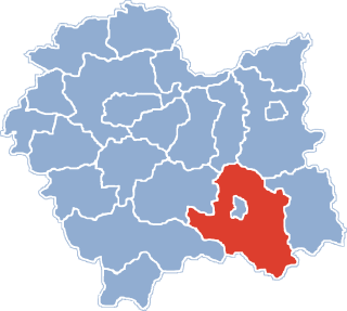
Klonowo is a settlement in the administrative district of Gmina Sztabin, within Augustów County, Podlaskie Voivodeship, in north-eastern Poland. It lies approximately 9 kilometres (6 mi) west of Sztabin, 18 km (11 mi) south of Augustów, and 65 km (40 mi) north of the regional capital Białystok.
Bęćkowo is a village in the administrative district of Gmina Szczuczyn, within Grajewo County, Podlaskie Voivodeship, in north-eastern Poland. It lies approximately 5 kilometres (3 mi) north-east of Szczuczyn, 11 km (7 mi) south-west of Grajewo, and 79 km (49 mi) north-west of the regional capital Białystok.
Ceromin is a settlement in the administrative district of Gmina Czarna Dąbrówka, within Bytów County, Pomeranian Voivodeship, in northern Poland. It lies approximately 7 kilometres (4 mi) south-east of Czarna Dąbrówka, 20 km (12 mi) north of Bytów, and 68 km (42 mi) west of the regional capital Gdańsk.

Qarabulaq is a village in the Gobustan Rayon of Azerbaijan.
Henryków is a village in the administrative district of Gmina Zduńska Wola, within Zduńska Wola County, Łódź Voivodeship, in central Poland. It lies approximately 40 kilometres (25 mi) south-west of the regional capital Łódź.
Kolonia Hubinek is a village in the administrative district of Gmina Ulhówek, within Tomaszów Lubelski County, Lublin Voivodeship, in eastern Poland, close to the border with Ukraine. It lies approximately 7 kilometres (4 mi) west of Ulhówek, 20 km (12 mi) east of Tomaszów Lubelski, and 119 km (74 mi) south-east of the regional capital Lublin.
Łyczanka is a village in the administrative district of Gmina Łososina Dolna, within Nowy Sącz County, Lesser Poland Voivodeship, in southern Poland.
Borów is a village in the administrative district of Gmina Jędrzejów, within Jędrzejów County, Świętokrzyskie Voivodeship, in south-central Poland. It lies approximately 7 kilometres (4 mi) south-west of Jędrzejów and 42 km (26 mi) south-west of the regional capital Kielce.
Lisów is a village in the administrative district of Gmina Morawica, within Kielce County, Świętokrzyskie Voivodeship, in south-central Poland. It lies approximately 7 kilometres (4 mi) south-east of Morawica and 22 km (14 mi) south of the regional capital Kielce.
Długojów is a village in the administrative district of Gmina Zagnańsk, within Kielce County, Świętokrzyskie Voivodeship, in south-central Poland. It lies approximately 8 kilometres (5 mi) north-west of Zagnańsk and 17 km (11 mi) north of the regional capital Kielce.
Hucisko is a village in the administrative district of Gmina Stryszawa, within Sucha County, Lesser Poland Voivodeship, in southern Poland. It lies approximately 8 kilometres (5 mi) south-west of Stryszawa, 15 km (9 mi) south-west of Sucha Beskidzka, and 57 km (35 mi) south-west of the regional capital Kraków.
Nowe Sarnowo is a village in the administrative district of Gmina Dzierzążnia, within Płońsk County, Masovian Voivodeship, in east-central Poland. Despite being founded for a significant period of time, its population has remained low.
Jelitowo is a village in the administrative district of Gmina Niechanowo, within Gniezno County, Greater Poland Voivodeship, in west-central Poland.
Tarchały Małe is a village in the administrative district of Gmina Odolanów, within Ostrów Wielkopolski County, Greater Poland Voivodeship, in west-central Poland. It lies approximately 6 kilometres (4 mi) north of Odolanów, 4 km (2 mi) south of Ostrów Wielkopolski, and 102 km (63 mi) south-east of the regional capital Poznań.
Krępkowice is a village in the administrative district of Gmina Cewice, within Lębork County, Pomeranian Voivodeship, in northern Poland. It lies approximately 5 kilometres (3 mi) north-west of Cewice, 11 km (7 mi) south of Lębork, and 63 km (39 mi) west of the regional capital Gdańsk.
Dębina is a settlement in the administrative district of Gmina Pelplin, within Tczew County, Pomeranian Voivodeship, in northern Poland. It lies approximately 3 kilometres (2 mi) north of Pelplin, 17 km (11 mi) south of Tczew, and 47 km (29 mi) south of the regional capital Gdańsk.
Krajewo-Kawęczyno is a settlement in the administrative district of Gmina Janowiec Kościelny, within Nidzica County, Warmian-Masurian Voivodeship, in northern Poland.
Końcewo is a village in the administrative district of Gmina Ruciane-Nida, within Pisz County, Warmian-Masurian Voivodeship, in northern Poland.