Related Research Articles
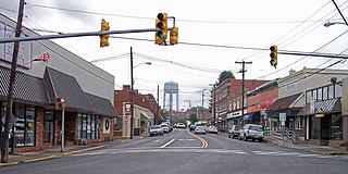
Oak Hill is a city in Fayette County, West Virginia, United States and is the primary city within the Oak Hill, WV Micropolitan Statistical Area. The micropolitan area is also included in the Beckley-Oak Hill, WV Combined Statistical Area. The population was 7,730 at the 2010 census. The city is also home to the historic Oak Hill Railroad Depot which still stands today as an artisan shop. Country singer Hank Williams died in Oak Hill on his way to a concert on January 1, 1953.
New Creek is an 18.4-mile-long (29.6 km) stream in eastern West Virginia. It is the third major West Virginia tributary to the North Branch Potomac River. Via the Potomac, it is part of the watershed of Chesapeake Bay.
Lunice Creek is a 7.3-mile-long (11.7 km) tributary of the South Branch Potomac River, belonging to the Potomac River and Chesapeake Bay watersheds. The creek is located in Grant County, West Virginia. Lunice Creek is created by its North and South Forks and empties into the South Branch at Petersburg.
Sitlington Creek is a tributary of the Greenbrier River in Pocahontas County, West Virginia. It was once an important stream for sending trimmed logs of white pine down the river to the St. Lawrence Boom and Lumber Company. It drains west where the confluence into the Greenbrier sits between Deer Creek and Clover Creek.
Walker Creek is a stream in Apache County, Arizona. Its mouth is at an elevation of 4,688 feet / 1,429 meters at its confluence with Chinle Creek. Its source is located at 36°41′28″N109°15′04″W, the confluence of Alcove Canyon and Tah Chin Lini Canyon in the Carrizo Mountains, from which it flows west and northwest to Chinle Creek at 36°57′42″N109°41′35″W. Hogansaani Spring, a tributary, is located on the south side of Walker Creek, at an elevation of 5,102 feet (1,555 m), midway downstream Walker Creek to its confluence with Chinle Creek.
Burner Mountain is a summit in West Virginia, in the United States. With an elevation of 4,295 feet (1,309 m), it is the 56th highest summit in the state of West Virginia.
Cobun Creek is a stream in the U.S. state of West Virginia.
Files Creek is a stream in the U.S. state of West Virginia.
Fishing Hawk Creek is a stream in the U.S. state of West Virginia.
Licking Creek is a stream in the U.S. state of West Virginia.
Paddy Knob is a summit in Virginia and West Virginia, in the United States. With an elevation of 4,478 feet (1,365 m), Paddy Knob is the 29th highest summit in the state of West Virginia, and the 14th highest in Virginia.
Pinch Creek is a stream in the U.S. state of West Virginia. It is a tributary of the Elk River.
Riffle Creek is a stream in the U.S. state of West Virginia. It is a tributary of the Tygart Valley River.
Roaring Creek is a stream in the U.S. state of West Virginia. It is a tributary of the Tygart Valley River. It rises on the western slopes of Rich Mountain, flows for approximately 13 miles, and joins the Tygart about 2 miles downstream of Aggregates, West Virginia.
See All is a summit in West Virginia, in the United States. With an elevation of 3,166 feet (965 m), See All is the 294th highest summit in the state of West Virginia.
Span Oak Run is a stream in the U.S. state of West Virginia.
Strange Creek is a stream in the U.S. state of West Virginia.
Sully is an unincorporated community in Randolph County, in the U.S. state of West Virginia.
Bear Creek is a stream in northwestern St. Francois County in the U.S. state of Missouri. It is a tributary of the Big River.
McCord Branch is a stream in Stone County in the Ozarks of southwest Missouri. It is a tributary of Crane Creek.
References
- ↑ U.S. Geological Survey Geographic Names Information System: Zebs Creek
- ↑ Kenny, Hamill (1945). West Virginia Place Names: Their Origin and Meaning, Including the Nomenclature of the Streams and Mountains. Piedmont, WV: The Place Name Press. p. 697.
- ↑ Maxwell, Hu (1899). The History of Barbour County, West Virginia: From Its Earliest Exploration and Settlement to the Present Time. Acme publishing Company. p. 321.
Coordinates: 38°57′42″N79°58′58″W / 38.96167°N 79.98278°W
| This article related to a river in West Virginia is a stub. You can help Wikipedia by expanding it. |