Zegge

Last updated

Zegge
Village
Heilige Maria Boodschapkerk P1070040.JPG
Heilige Maria Boodschapkerk
2010-NL-P10-Noord-Brabant-positiekaart-gemnamen.jpg
Red pog.svg
Zegge
Location in the province of North Brabant in the Netherlands
Netherlands location map.svg
Red pog.svg
Zegge
Zegge (Netherlands)
Coordinates: 51°33′21″N4°31′1″E / 51.55583°N 4.51694°E / 51.55583; 4.51694
Country Netherlands
Province North Brabant
Municipality Rucphen
Area
[1]
  Total5.20 km2 (2.01 sq mi)
Elevation
[2]
5.1 m (16.7 ft)
Population
 (2021) [1]
  Total2,035
  Density390/km2 (1,000/sq mi)
Time zone UTC+1 (CET)
  Summer (DST) UTC+2 (CEST)
Postal code
4735 [1]
Dialing code 0165

Zegge is a village located in the municipality of Rucphen, North Brabant in the Netherlands. On 1 January 2020, the village had 2,045 inhabitants. [3] Viewed from the four other villages in the municipality of Rucphen, Zegge is located on the other side of the A58 motorway. This combined with its small size, makes it so that much of the daily life of its inhabitants centers around the nearby city of Roosendaal.

Contents

Etymology

The name Zegge comes from low-lying and often submerged pasture, where a lot of sedge (zegge in Dutch) occurs and also reed grass that is popularly referred to as zegge. The village "Zegge" is not the same as (the adjacent) "Seppe". This is an airport that was officially named Breda International Airport in 2014, but is still popularly called Seppe.

History

In 1125 the area around Zegge was referred to as Thurlicht-ter-Venne. The Deurlechts Vaartje, west of Zegge, is a reminder of this old name. It was part of the Dorlecht area. It was a border area between the lordships of Breda and Bergen op Zoom, which was split off from it. When settling the border disputes between the two areas in 1291 they were referred to as De Moeren boven Kalsdonk (The swamps above Kalsdonk), these belonged to Bergen op Zoom. In 1354 people spoke of Nieuwe Dorlecht (New Dorlecht), whereby the Thurlicht-ter-Venne was known as Oude Dorlecht (Old Dorlecht).

The border was finally settled in 1458. The current Zegge, then called Land van Bergen boven den Nieuwenberg (Land of Mountains above the Nieuwenberg), still belonged to Bergen op Zoom. To the long name was added: alias Zegge, and during the 18th century the name Den Lande van Zegge (The Lands of Zegge) became more and more common.

Zegge formed an independent estate with its own 'schepenbank'. This was chaired by the landdrost of the east quarter of Bergen op Zoom. The 'schepenbank' had the high jurisdiction.

Dyeing of this and surrounding areas began in 1290. 300 bunder of land was issued to Gerard de Spiekere by Raso I van Gaveren, Lord of Breda. [4] The first occupation was reported in the 14th century. In 1687 about 300 people lived there, a number that remained almost constant for centuries, only to increase noticeably in the 2nd half of the 19th century.

For a long time, Zegge was therefore not an independent parish, but only had a chapel. It is said that this Mariakapel (Virgin Mary chapel) was founded by a seaman after the St. Elisabeth's flood of 1421. This would have been built as a thanks for his safe return home. The chapel was first mentioned in writing in 1459. A new chapel is said to have been built later, dedicated to the Annunciation, described in 1615. The chapel attracted many pilgrims. From 1648 the chapel was no longer allowed to be used by Catholics, but it was re-opened in 1810. In 1833 the chapel was elevated to a parish church, but in 1848 a church was built opposite the chapel and has functioned as such ever since. The new, current parish church was completed in 1912. The chapel was replaced by the current one in 1922. Pilgrimages still take place, and a procession is held on 31 May to close the month of May.

Stagnation

As a small core, the permitted growth of the village has been minimal for many years; only a few additional homes may be built each year. Only its own residents are eligible for building land in the village. There is therefore population aging in the village.

Places of interest

Related Research Articles

Roosendaal Municipality in North Brabant, Netherlands

Roosendaal is both a city and a municipality in the southern Netherlands, in the province of North Brabant.

Rozendaal Municipality in Gelderland, Netherlands

Rozendaal is a municipality and a town in the eastern Netherlands, in the province of Gelderland. The town, next to Arnhem and Velp, is known for the Rozendaal Castle and its water fountain follies (bedriegertjes).

Rucphen Municipality in North Brabant, Netherlands

Rucphen is a municipality and a town in the southern Netherlands between Roosendaal and Etten-Leur, south of the railway, but without a train-station.

Heiloo Municipality and town in North Holland, Netherlands

Heiloo is a municipality and town in the Netherlands, located in the province of North Holland. The community is part of the cooperation region Kennemerland and is located in the historical region of West Friesland. Heiloo had a population of 23,464 in 2019.

Aldtsjerk Village in Friesland, Netherlands

Aldtsjerk is a village on the main road from Leeuwarden to Dokkum. It is part of Tytsjerksteradiel municipality, Friesland, the Netherlands and had around 615 inhabitants as of January 2018.

Breda City and municipality in North Brabant, Netherlands

Breda is a city and municipality in the southern part of the Netherlands, located in the province of North Brabant. The name derived from brede Aa and refers to the confluence of the rivers Mark and Aa. Breda has 184,762 inhabitants on 1 December 2021.

Beltrum Village in Gelderland, Netherlands

Beltrum is a village in the region called Achterhoek in the province of Gelderland in the Netherlands.

Koudum Village in Friesland, Netherlands

Koudum is a village in the northern Netherlands. It is located in Súdwest-Fryslân, Friesland. Nearby villages include Molkwerum to the west, Workum to the north and Hemelum to the south. The population of Koudum was 2,700 in 2019. The nearest train station is the Koudum-Molkwerum railway station.

Terhole Village in Zeeland, Netherlands

Terhole or Ter Hole is a village in the Dutch province of Zeeland. It is a part of the municipality of Hulst, and lies about 26 km southwest of Bergen op Zoom.

Wouw Village in North Brabant, Netherlands

Wouw is a village in the southern Netherlands. It is located in North Brabant, between the cities Roosendaal and Bergen op Zoom, close to the border with Belgium.

Bergharen Village in Gelderland, Netherlands

Bergharen is a village in the Netherlands, in the municipality of Wijchen. It was a separate municipality until 1984. There is a windmill, De Verrekijker, which has been converted to a holiday cottage.

Velp is a Dutch village located east of Arnhem within the municipality of Rheden, between Arnhem, Rozendaal, and the town of Rheden.

Halsteren Town in North Brabant, Netherlands

Halsteren is a town in the Dutch province of North Brabant. It is located in the municipality of Bergen op Zoom, about 1 km north of that city. Halsteren has an old church from the 14th century and a new church, built in 1919. A little village called Polder was located between Halsteren and Tholen in the Middle Ages.

Westmaas

Westmaas is a village in the Dutch province of South Holland. It is located about 14 km south of the city of Rotterdam, next to Mijnsheerenland in the municipality of Hoeksche Waard. In 2020, the population was 2065.

Heerle Village in North Brabant, Netherlands

Heerle is a village in the municipality of Roosendaal, in the Dutch province of North Brabant. Before the municipal reorganisation of 1997, Heerle was part of the municipality of Wouw. It lies between the cities of Bergen op Zoom and Roosendaal.

Finsterwolde Village in Groningen, Netherlands

Finsterwolde is a village in the Dutch province of Groningen, about 7 km northeast of the city of Winschoten. Finsterwolde was a separate municipality until 1990, when it was merged with Beerta into Reiderland. In 2010 Reiderland merged into the municipality Oldambt. The old municipality of Finsterwolde included six small nearby or connecting settlements. These are also taken into account in the population estimate of 2008, without which the actual population, purely based on the centre and new developments, would be 1250. The village is known for the Galery Waalkens.

Bosschenhoofd Village in North Brabant, Netherlands

Bosschenhoofd is a village in the municipality of Halderberge in the province of North Brabant in the Netherlands. The village is also known as Seppe, a name used by the nearby Seppe Airport. Seppe was derived from Jacobus Sep who ran an inn. Before the municipal reorganization of 1997, Bosschenhoofd belonged to the municipality of Hoeven.
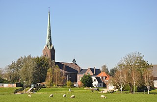
Overdinkel Village in the east of the Netherlands

Overdinkel is a village in the Twente region of the eastern Netherlands, in the municipality of Losser. It is named for the nearby river Dinkel. Its population in 2012 was 4,255. The territories of the Netherlands and the German Länder of North Rhine-Westphalia and Lower Saxony meet at a point to the east of Overdinkel.

Lottum Village in Limburg, Netherlands

Lottum is a village in the Dutch province of Limburg. It is located in the municipality of Horst aan de Maas.

Nieuwerkerk (Schouwen-Duiveland) Village in Zeeland, Netherlands

Nieuwerkerk is a village in the southwest Netherlands, 50 km southwest of Rotterdam. It is situated in the municipality of Schouwen-Duiveland, Zeeland. The village had 2,680 residents on 1 January 2020. Nieuwerkerk was an independent municipality until 1961, when it merged into the municipality Duiveland, and it merged again into the municipality Schouwen-Duiveland in 1997.

References

  1. 1 2 3 "Kerncijfers wijken en buurten 2021". Central Bureau of Statistics. Retrieved 18 April 2022.
  2. "Postcodetool for 4735AA". Actueel Hoogtebestand Nederland (in Dutch). Het Waterschapshuis. Retrieved 18 April 2022.
  3. Statistiek, Centraal Bureau voor de. "Kerncijfers wijken en buurten 2020". Centraal Bureau voor de Statistiek (in Dutch). Retrieved 18 April 2021.
  4. "Ontdekkingstocht vanuit Roosendaal naar de turfwinning in de 14eeeuw" (PDF). 12 December 2013. Archived from the original (PDF) on 12 December 2013. Retrieved 18 April 2021.
  5. "Zegge, Onze Lieve Vrouwestraat 107 – Maria Boodschap – Reliwiki". reliwiki.nl. Retrieved 18 April 2021.
  6. "Zegge, Onze Lieve Vrouwestraat 108 – Kapel O.L. Vrouw van Zegge – Reliwiki". reliwiki.nl. Retrieved 18 April 2021.