
The Schenk von Stauffenberg family is a Roman Catholic Uradel German noble family from Swabia, Germany. The family's best-known recent member was Colonel Claus Schenk Graf von Stauffenberg – the key figure in the 1944 "20 July plot" to assassinate Adolf Hitler.

Franconian Switzerland is an upland in Upper Franconia, Bavaria, Germany and a popular tourist retreat. Located between the River Pegnitz in the east and the south, the River Regnitz in the west and the River Main in the north, its relief, which reaches 600 metres in height, forms the northern part of the Franconian Jura (Frankenjura). Like several other mountainous landscapes in the German-speaking lands, e.g. Holstein Switzerland, Märkische Schweiz, or Pommersche Schweiz, Franconian Switzerland was given its name by Romantic artists and poets in the 19th century who compared the landscape to Switzerland. Franconian Switzerland is famous for its high density of traditional breweries.

Heiligenstadt in Oberfranken is a community with market rights in the Upper Franconian district of Bamberg. The town clusters round the base of Schloss Greifenstein.

Baunach is a town in the Upper Franconian district of Bamberg and the seat of the administrative community (Verwaltungsgemeinschaft) of Baunach. Until administrative reform in 1972, Baunach belonged to the Lower Franconian district of Ebern.

Ebermannstadt is a town in the district of Forchheim, in Bavaria, Germany. It is situated 10 km northeast of Forchheim and 25 km southeast of Bamberg.

Kleinwallstadt is a market community in the Miltenberg district in the Regierungsbezirk of Lower Franconia (Unterfranken) in Bavaria, Germany and the seat of the like-named Verwaltungsgemeinschaft.

Burgwindheim is a municipality with market rights in the west of the Upper Franconian district of Bamberg and a member of the administrative community (Verwaltungsgemeinschaft) of Ebrach.

Buttenheim is a market town in the Upper Franconian district of Bamberg and lies in the Regnitz Valley between Bamberg and Nuremberg, Germany.

Ebrach is a municipality with market rights in the Upper Franconian district of Bamberg and the seat of the Verwaltungsgemeinschaft of Ebrach.

Obersinn is a market community in the Main-Spessart district in the Regierungsbezirk of Lower Franconia (Unterfranken) in Bavaria, Germany and a member of the Verwaltungsgemeinschaft of Burgsinn.

Thüngen is a market community in the Main-Spessart district in the Regierungsbezirk of Lower Franconia (Unterfranken) in Bavaria, Germany and a member of the Verwaltungsgemeinschaft of Zellingen.

Tiefenbach is a municipality in the district of Passau in Bavaria in Germany.

The Prince-Bishopric of Paderborn was an ecclesiastical principality (Hochstift) of the Holy Roman Empire from 1281 to 1802.

Schloss Fronberg is a castle in Schwandorf in Bavaria.
Dreuschendorf is a small village located in Bavaria, Germany. It is in Upper Franconia, in the Bamberg district. Dreuschendorf is a constituent community of Buttenheim.

The Altes Schloss near Bad Berneck in south Germany is a ruined castle built in the Gothic style as an Amtsburg towards the end of the High Middle Ages. The castle lies on the Schlossberg of Bad Berneck in the Upper Franconian district of Bayreuth in Bavaria. Today the lofty keep is the emblem of this small spa town.

Buch am Forst is a village of 530 inhabitants in the district town (Kreisstadt) of Lichtenfels in the state of Bavaria in Germany. It is 6 kilometers northwest of Lichtenfels and at the western edge of the Lichtenfels Forest. Bundesautobahn 73 [Federal Highway] runs approximately a half-mile (1 km) to the east, while Kreisstraße [District Road] LIF27 goes through the village itself.
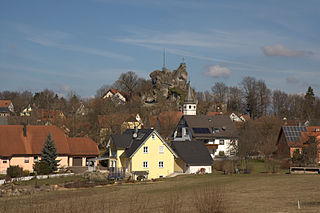
Wichsenstein Castle was a hill castle, once owned by noblemen, on a steep and prominent rock reef (Felsriff) outcrop above the church village of Wichsenstein in the Upper Franconian county of Forchheim in Bavaria, Germany. The castle has been completely demolished and there are no visible remains. The castle rock is now just used as a viewing point.

Schlüsselstein Castle was a castle and the seat of a noble family, probably dating to the High Middle Ages, the remains of which lie above the town of Ebermannstadt in the Upper Franconian county of Forchheim in the south German state of Bavaria. The site is known locally as Burgstall Schlüsselstein.
Wiesentheid Castle is a listed building in the market town of Wiesentheid, Kitzingen, in Lower Franconia, Bavaria, Germany. The complex includes the Baroque town centre with the parish church and the eponymous castle of the Counts of Schönborn.

