Heiligenstadt in Oberfranken

Last updated
Heiligenstadt in Oberfranken
Heiligenstadt vom Pavillon.jpg
Heiligenstadt
Wappen von Heiligenstadt (Oberfranken).svg
Location of Heiligenstadt in Oberfranken within Bamberg district
Heiligenstadt in Oberfranken in BA.svgZückshuter ForstWinkelhofer ForstSteinachsrangenSembergLindach (unincorporated area)Koppenwinder ForstHauptsmoorwaldGeisberger ForstEichwald (unincorporated area)Ebracher ForstEbracher ForstWalsdorfLauterGundelsheimKönigsfeldAltendorf
Germany adm location map.svg
Red pog.svg
Heiligenstadt in Oberfranken
Bavaria location map.svg
Red pog.svg
Heiligenstadt in Oberfranken
Coordinates: 49°52′N11°10′E / 49.867°N 11.167°E / 49.867; 11.167 Coordinates: 49°52′N11°10′E / 49.867°N 11.167°E / 49.867; 11.167
Country Germany
State Bavaria
Admin. region Oberfranken
District Bamberg
Government
   Mayor (202026) Stefan Reichold [1] (SPD)
Area
  Total76.71 km2 (29.62 sq mi)
Elevation
304 m (997 ft)
Population
 (2020-12-31) [2]
  Total3,482
  Density45/km2 (120/sq mi)
Time zone UTC+01:00 (CET)
  Summer (DST) UTC+02:00 (CEST)
Postal codes
91332
Dialling codes 09198
Vehicle registration BA
Website www.markt-heiligenstadt.de
Easter in Heiligenstadt Ostern in Heiligenstadt 2007.jpg
Easter in Heiligenstadt

Heiligenstadt in Oberfranken (officially: Heiligenstadt i. OFr.) is a community with market rights in the Upper Franconian district of Bamberg. The town clusters round the base of Schloss Greifenstein.

Contents

To further tourism the old school was converted into today's town hall, the historic marketplace was remodelled, and at Easter it is adorned with an Easter fountain. Furthermore, an old barn was converted into a community centre.

The community with its houses under memorial protection and its historically interesting church is a well known outing destination.

Visitors are especially numerous at Easter when many come to see the Franconian Switzerland’s Easter fountains.

The Evangelical St.-Veit- und St.-Michaels-Kirche (church) goes back to a former tithe barn. The freestanding belltower stands on what is left of a former castle. Unusual for an Evangelical church is the elaborate Baroque painting on the wooden galleries and the panelled ceilings.

Geography

Heiligenstadt lies in the Bamberg district’s southeastern corner. The 24 Gemeindeteile lie along the Leinleiter Valley and on the abutting Jura Plateau. Veilbronn lies 329 m above sea level. The greatest elevation is the Altenberg (mountain) behind Zoggendorf at 583 m above sea level. The villages on the heights from Volkmannsreuth to Teuchatz belong to the Lange Meile ("Long Mile"). The North Jura joins with the Seigelstein near Lindach. The mountain villages east of the Leinleiter are part of the Aufseßer Gebirge (mountain range).

Heiligenstadt, in the Naturpark Fränkische Schweiz-Veldensteiner Forst (nature park), is the most important place in the Leinleiter Valley.

Constituent communities

Heiligenstadt is a small centre with 24 constituent communities (Gemeindeteile). Within municipal limits is an area of 77 km2 making Heiligenstadt the district's third biggest community; however, it belongs to the more thinly populated areas. In all of Heiligenstadt's centres live roughly 3,700 inhabitants.

Brunn im Markt Heiligenstadt OFr.png BrunnHeiligenstadt2005.jpg Brunn has an area of 5.57 km2, lying on a plateau between Hohenpölz and Schloss Greifenstein. Brunn Bevoelkerungsanteil Heiligenstadt in Oberfranken.png 130 inhabitants
Burggrub im Markt Heiligenstadt OFr.png Leinleiter in Burggrub.jpg Burggrub lies on the ridge of the Altenberg and below the 525-m high Eichenberg in the Leinleiter Valley, 378 m above sea level. Burggrub Bevoelkerungsanteil Heiligenstadt in Oberfranken.png 167 inhabitants
Geisdorf im Markt Heiligenstadt OFr.png Damwild vor Geisdorf.jpg The hamlet of Geisdorf lies roughly 500 m above sea level on a terrace of the Jura. Geisdorf Bevoelkerungsanteil Heiligenstadt in Oberfranken.png 27
Greifenstein im Markt Heiligenstadt OFr.png Heiligenstadt-Greifenstein1-Asio.JPG Schloss Greifenstein lies 502 m above sea level and is the seat of the noble Stauffenberg family. Geisdorf Bevoelkerungsanteil Heiligenstadt in Oberfranken.png 11 inhabitants
Heiligenstadt im Markt Heiligenstadt OFr.png HeiligenstadtPavillon.jpg Heiligenstadt is the community's main and namesake centre, dwarfing all of its outlying centres with a population of 1,333. Heiligenstadt Bevoelkerungsanteil Heiligenstadt in Oberfranken.png 1,333 inhabitants
Heroldsmuehle im Markt Heiligenstadt OFr.png Heroldsmuehle Winter.jpg The Heroldsmühle lies near the Leinleiter's source. Heroldsmuehle Bevoelkerungsanteil Heiligenstadt in Oberfranken.png 9 inhabitants
Herzogenreuth im Markt Heiligenstadt OFr.png Ortsbild Herzogenreuth.jpg Herzogenreuth lies 566 m above sea level, making it the Bamberg district's highest village. Herzogenreuth Bevoelkerungsanteil Heiligenstadt in Oberfranken.png 139 inhabitants
Hohenpoelz im Markt Heiligenstadt OFr.png HohenpoelzS.jpg Hohenpölz with its 30-metre high church belltower can be seen from almost everywhere in the heights of the Franconian Jura. It has an area of 7.57 km2. Hohenpoelz Bevoelkerungsanteil Heiligenstadt in Oberfranken.png 141 inhabitants
Kalteneggolsfeld im Markt Heiligenstadt OFr.png Dorfkapelle Kalteneggolsfeld.jpg Kalteneggolsfeld has an area of 4.18 km2 and an elevation of 520 m. It lies on the edge of the Lange Meile (“Long Mile”). Kalteneggolsfeld Bevoelkerungsanteil Heiligenstadt in Oberfranken.png 141 inhabitants
Leidingshof im Markt Heiligenstadt OFr.png Leidiingshof (Scheunen).jpg Leidingshof Leidingshof Bevoelkerungsanteil Heiligenstadt in Oberfranken.png 33 inhabitants
Lindach im Markt Heiligenstadt OFr.png Schafhof Lindach.jpg Lindach was until administrative reform Bavaria's smallest community. Lindach Bevoelkerungsanteil Heiligenstadt in Oberfranken.png 69 inhabitants
Neudorf im Markt Heiligenstadt OFr.png Heiligenstadt N6.jpg Not far from Neudorf begins the Wein Valley, which leads to Veilbronn. Neudorf Bevoelkerungsanteil Heiligenstadt in Oberfranken.png 49 inhabitants
Neumuehle im Markt Heiligenstadt OFr.png Neumuehle und Schloss Greifenstein.jpg The Neumühle lies on the Volletsbach 370 m above sea level below Schloss Greifenstein (castle) and is included in most depictions of the castle. Neumuehle Bevoelkerungsanteil Heiligenstadt in Oberfranken.png 24 inhabitants
Oberleinleiter im Markt Heiligenstadt OFr.png OberleinleiterStrasse.jpg Oberleinleiter lies 386 m above sea level. The village's landmark is the 520-m high Kreuzsteinfelsen, from which there is a panorama over the countryside as far as the villages of the Bamberger Jura. Oberleinleiter Bevoelkerungsanteil Heiligenstadt in Oberfranken.png 177 inhabitants
Oberngrub im Markt Heiligenstadt OFr.png Oberngrub Windraeder.jpg Oberngrub has an area of 3.7 km2. It is part of the Lange Meile (“Long Mile”). Oberngrub Bevoelkerungsanteil Heiligenstadt in Oberfranken.png 172 inhabitants
Reckendorf im Markt Heiligenstadt OFr.png Reckendorf Markt Heiligenstadt.jpg Reckendorf lies in a side valley of the Leinleiter running north–south, two kilometres north of Heiligenstadt. Reckendorf Bevoelkerungsanteil Heiligenstadt in Oberfranken.png 90 inhabitants
Siegritz im Markt Heiligenstadt OFr.png Siegritz Scheune.jpg Siegritz has an area of 9.24 km2. It lies near the Wern Valley on the Alb plateau about 456 m above sea level in the Bamberg district's southeasternmost reaches. Siegritz Bevoelkerungsanteil Heiligenstadt in Oberfranken.png 190 inhabitants
Stuecht im Markt Heiligenstadt OFr.png Stuecht Haus.jpg Stücht once belonged to the Lords of Stauffenberg at Schloss Greifenstein. Stuecht Bevoelkerungsanteil Heiligenstadt in Oberfranken.png 76 inhabitants
Teuchatz im Markt Heiligenstadt OFr.png Teuchatz Markt Heiligenstadt.jpg Teuchatz lies in a small basin (545 m above sea level) on the edge of the western heights of the Franconian Jura. Teuchatz Bevoelkerungsanteil Heiligenstadt in Oberfranken.png 213 inhabitants
Tiefenpoelz im Markt Heiligenstadt OFr.png Tiefenpoelz Markt Heiligenstadt.jpg Tiefenpölz has a noteworthy St. Martin's Parish Church that rises over the village. Tiefenpoelz Bevoelkerungsanteil Heiligenstadt in Oberfranken.png 138 inhabitants
Traindorf im Markt Heiligenstadt OFr.png Traindorf lies in the Leinleiter Valley hardly a kilometre south of Heiligenstadt. Traindorf Bevoelkerungsanteil Heiligenstadt in Oberfranken.png 155 inhabitants
Veilbronn im Markt Heiligenstadt OFr.png VeilbronnDorf.JPG Veilbronn lies in the Leinleiter Valley south of Heiligenstadt and is well known as a holiday village. Veilbronn Bevoelkerungsanteil Heiligenstadt in Oberfranken.png 72 inhabitants
Volkmannsreuth im Markt Heiligenstadt OFr.png Volkmannsreuth 03.jpg Volkmannsreuth lies on the plateau. Volkmannsreuth Bevoelkerungsanteil Heiligenstadt in Oberfranken.png 54 inhabitants
Zoggendorf im Markt Heiligenstadt OFr.png Osterbrunnen in Zoggendorf 07.jpg Zoggendorf lies in the Leinleiter Valley. Towering over it is the 585-m high Altenberg. Zoggendorf Bevoelkerungsanteil Heiligenstadt in Oberfranken.png 105 inhabitants
All population figures are as at 1 January 2005.

History

Prehistoric finds establish that the market community's municipal area was already populated thousands of years ago, at least at times. However, permanent small communities only arose about the year 500 at the time of the Migration Period (or Völkerwanderung). Documentary mention, though, came only much later.

The community's villages arose about a thousand years ago. Heiligenstadt itself already existed before the Bishopric of Bamberg was founded in 1007.

In the Leinleiter Valley were lordly seats of the Knights of Streitberg. In 1525, the peasants revolted and inflicted heavy damage upon the castles. In 1541, the Emperor granted Heiligenstadt market privilege.

In 1580, the Reformation was introduced into Heiligenstadt and Unterleinleiter. In 1690, the Prince-Bishop of Bamberg, Marquard Sebastian Schenk von Stauffenberg inherited the knightly estates of Greifenstein and Burggrub together with patronage over Heiligenstadt. The Counts Schenk von Stauffenberg still live at Greifenstein Castle and the palatial estate of Burggrub today. The villages in the community's northern area grew out of the former Bamberg Ämter. Here there was no change in the prevailing religion.

Through the Reichsdeputationshauptschluss in 1803, the community passed to Bavaria.

In the course of administrative reform in Bavaria, the communities of Brunn, Burggrub, Hohenpölz, Oberleinleiter, Siegritz, Stücht, Traindorf and Zoggendorf joined the market community of Heiligenstadt.

Wars

Hussite storm (1430)

The first major war of which anything exact is known was the Hussite War in 1430. The Heiligenstadt parish chronicle reports that in 1429, single Bohemian cohorts destroyed parts of Heiligenstadt and the whole of Burggrub and Zoggendorf. By paying an immense sum of money, the Margrave Friedrich, who had been summoned for help, managed to get the Hussite leader Prokop to turn away. The money had to be made up through special taxes paid by the subjects.

German Peasants' War (1525)

During the German Peasants' War of 1525, peasants from the Bamberg area plundered and burnt the castle at Burggrub. A cohort from Ebermannstadt plundered the castle at Veilbronn. Once the revolt had been quelled by the Swabian League, five of the peasants’ leaders were beheaded at the market in Hollfeld.

Second Margrave War (1552–1554)

The Second Margrave War was set off in 1552 by the Margrave Albrecht Alcibiades of Brandenburg-Kulmbach. In April 1553, the Margrave's horsemen laid waste to the village of Herzogenreuth. Hohenpölz was supposed to pay protection money to receive a charter to avoid the worst.

Thirty Years' War (1618–1648)

The Thirty Years' War caused the most damage of all wars. On 10 September 1632, the Mistendorf clergyman reported the plunder of the villages of Teuchatz and Tiefenpölz, both served by him. The perpetrators, however, were not the Swedes, but Imperial troops who were fighting on the Catholic side. The Kastner (“bursary officer”) of the Streitburg wrote in 1633 to the Margrave in Kulmbach telling him that “the subjects had all their livestock and grain taken away and many were horridly murdered. In some villages more than half the subjects are said to have died wretchedly.” Farms were forsaken in Volkmannsreuth, Brunn, Oberleinleiter, Burggrub and Stücht. Meanwhile, times had become so uncertain that hardly any more written records were kept. Moreover, no-one knew anymore who was fighting for or against whom. On 12 June 1634, Weimar horsemen plundered the villages and took the farmers’ livestock away. An eyewitness wrote:

On the same day we saw on the mountains near Hollfeld in three places villages burning; the flames reached up to the clouds. [3]

In connection with this, Heiligenstadt may also have been affected.

Seven Years' War 1756–1763

The Seven Years' War between Prussia and Austria was about supremacy in Central Europe. The Prussians moved by way of Fürth towards the north and in the summer of 1757 they were quartered in Ebermannstadt, which they plundered before they then moved up the Leinleiter. On the way, they extorted all that there was to have: money, livestock, food. Under the soldiers’ march, Veilbronn and Traindorf both suffered. Barely a year later came the Prussians’ next invasion, and a year after that came a third. In November 1762, Prussian troops stayed in the area around Heiligenstadt for three weeks.

Napoleonic Wars (1796)

In the Napoleonic Wars, an army corps under General Jourdan on a retreat overran the Franconian Switzerland. French military police rode through the villages and extorted protection money from the peasants – sometimes many times in quick succession.

Franco-Prussian War (1870)

With the annexation of Alsace-Lorraine, many of those called up for military service were stationed at the Metz garrison, some of whom stayed for ever and took wives. Among these was Jean Puff from the Heroldsmühle.

First World War

Even though the First World War took place far from Heiligenstadt, the human losses were roughly as high as they had been in the Thirty Years' War.

Second World War

As the Second World War was drawing to an end, the villagers hid with their livestock while the village elders approached United States troops with a white flag to surrender their village. The Americans established a military government, ordering, on pain of death, the surrender of all firearms. Near Teuchatz, a bomb disposal site was set up, where Wehrmacht munitions were destroyed.

Chronology

1541 Market privileges
1580 Reformation in Heiligenstadt and Unterleinleiter
1803 Heiligenstadt passes to Bavaria
1915 Railway connection by way of Ebermannstadt to Forchheim
1968 Abandonment of railway
1971 Administrative reform

Community’s name

First documented form: "Haldenstat" Heiligenstadt OFr 1168 Haldenstat.jpg
First documented form: “Haldenstat

The placename Heiligenstadt has nothing to do with the German word heilig (“holy”). It is merely another example of how names can change over time. The community was first mentioned in 1365 as Haldenstat, meaning “town at the slope” (Halde is still a German word for “slope”).

In a report from the time of the Franconian Switzerland's discovery (that is, as a tour destination), Dr. Gottlieb Zimmermann describes in 1840 a hiking route along the Leinleiter wherein he shows by mentioning the community's old name that the name Heiligenstadt has nothing to do with Heiligen (“Holy Ones” or “Saints”), but rather with the word Halde:

Heiligenstadt, auch das lutherische Hallstadt genannt, ist ein hübscher Marktflecken im Thale, wo die Reisenden mehrere und ziemlich gute Wirthshäuser finden. [4]

The community was called Lutherisches Hallstadt to distinguish it from Hallstadt near Bamberg, which was (and is) mostly Catholic.

Religion

Within the market community's limits, Catholic and Evangelical villages lie in the area of the Archdiocese of Bamberg: In Leidingshof there is not a single Catholic, in the villages of the parish of Tiefenpölz, almost nobody is Evangelical. In the heart of the main community, mostly Lutherans live, whereas in the outlying newer developments, most people are Catholic. All together, the ratio between the two faiths stands at roughly 1:1.

Churches

Roman Catholic church

Heiligenstadt-Burggrub is a patronage parish with presentation rights of the Schenken von Stauffenberg, Greifenstein, and calls itself St. Paul Heiligenstadt-Burggrub.

Evangelical Lutheran church

The Evangelical Lutheran parish has its centre in the St.-Veit- und St.-Michaels-Kirche.

Free churches

Furthermore, there is in Heiligenstadt an Evangelical Free Church Congregation (Baptists). It has its seat in the family centre (sponsored by the Familienzentrum der Evangelisch-Freikirchlichen Gemeinden in Nordbayern e. V. )

Jews

Already by 1430 there were Jews from nearby towns doing trade with peasants in Heiligenstadt. In Heiligenstadt itself, it is believed there were no Jews at that time.

According to documents, in 1605 there were at least three Jewish families living in Heiligenstadt. In 1617, there were seven. According to a directory kept by a clergyman named Knab from Heiligenstadt, there were 1,758 souls in his parish all together, 239 of them Catholic and 58 Jewish.

In 1692, a shechita and slaughter order was in effect. In 1734, Jews were allowed to carry their books publicly, accompanied by musicians, into their synagogue.

Not seldom, the Jews’ business acumen led to envy. In 1699, peasants from the Scheßlitz area rose up together against the Jews. First, the Heiligenstadters wanted to stand against them. However, once they learnt that only Jews were to be harmed, they forsook their resistance. Some even took part in the ensuing pogrom. In 1716, the Jews requested lordly protection when news reached Heiligenstadt that a “young Christian girl” in Pretzfeld had been murdered, leading the Jews to fear that they would be the targets of a revenge campaign by those who suspected them.

The last relic of Jewish life is the Jewish cemetery on the Berg Kuhlich, mentioned as early as 1608. The last burial here took place about 1900. An unknown witness noted in the 1950s:

Odd things happened at Jewish burials. The dead man or woman was driven to the graveyard on the Kuhlich by way of the Wischberg on a hay cart pulled by a horse. The grave was quickly dug beforehand. The dead were laid in a death shirt – already sewn while the dead were still alive – in a simple, unplaned coffin made without nails or screws by the local cabinetmaker, like a chest, from four boards. A little bag with coins went with the dead. Women, other than the nearest blood kin, had to stay in their dwellings. It was not allowed to give flowers, not even the smallest nosegay. With the customary head covering, the men laid the coffin in the grave, with the dead’s face towards the east. It all happened with great swiftness. Each one present threw three shovelfuls of earth into the grave. The Jewish teacher – in my youth it was the Jewish teacher from Aufseß – meanwhile read from the prayer book the Kadish, the prayer. [5]

Politics

The community council is made up of 16 members, listed here by party or voter community affiliation, and also with the number of seats that each holds:

Coat of arms

The community's arms show the Archangel Michael with golden wings, red cloak and blue robe, golden helmet with a red tuft of feathers on the head standing on a silver cloud and holding a blue flaming sword in his right hand and a green olive twig in his left.

When the outlying communities of Brunn, Burggrub, Hohenpölz, Oberleinleiter, Siegritz, Stücht, Traindorf and Zoggendorf were amalgamated with Heiligenstadt, the new, bigger community kept the old Heiligenstadt's coat of arms, which at arms revision in 1819 was held to be the “longest borne arms”. Older seals, however, have not come down to the present day.

The Archangel Michael is, along with Saint Vitus, the holy protector of the now Evangelical St.-Veit- und St.-Michaels-Kirche in Heiligenstadt.

Economy and infrastructure

Economy

The industrialization arising in the surrounding towns led to the outflow of both small craftsmen and youth. Even the refugees driven from formerly German lands east of the Oder and Neiße after the Second World War did not decisively change this emigration pattern. Not all of them stayed for any length of time. It was only in the 1970s that an upswing was brought about when Mayor Daum did all that he could to make Heiligenstadt more attractive to those seeking work. To this end, jobs were created along with shopping facilities. The state furnished funds for this, making it possible to overhaul the community core.

Transport connections

Railway

Bridge over the Leinleitertal and former railway line, now a cycle path VeilbronnBruecke.jpg
Bridge over the Leinleitertal and former railway line, now a cycle path

From 1915 to 1968, Heiligenstadt was the end of the Heiligenstadt–Ebermannstadt spur line, which also afforded a connection to Forchheim. When the time came to build it, there were still some who needed convincing of the project's wisdom. Put forth as arguments in its favour were the basalt mined on the Upper Leinleiter, iron ore finds near Königsfeld, the wood from the Stauffenberg and Aufseß forests, loading grain and livestock, and the looming tourism in the Franconian Switzerland.

For those whose lands abutted the projected right of way, building the railway meant a financial burden, for the railway required acquisition of lands needed not only for this right of way but also for other building works such as access ways. Even communities farther away from the railway were ready to throw their lot in with those that were nearer in the hope that there would one day be an extension to Hollfeld or Scheßlitz.

The people of Gasseldorf, on the other hand, caused the railway builders difficulties. They were unwilling to yield land for the project, making forcible expropriation measures necessary.

In June 1913, building work began. There was 117 000 m³ of earth to be moved, 11 bridges to be built, and the Leinleiter riverbed had to be shifted in five places, making plenty of work for more than 100 workers and many residents.

In 1915, the project could fulfil its purpose. On 4 October 1915, the Ebermannstadt-Heiligenstadt local railway went into service. The schoolteacher Hans Spörl wrote:

A Heiligenstadter, engine driver Fritz Krasser, son of former mayor Friedrich Krasser in Heiligenstadt, who in his own time was already pushing for a railway to be built, had asked to be allowed to drive the first train into his hometown. His wish was granted.

It goes on to say:

Mayor Richter greeted the guests who had arrived, wished them a hearty welcome and expressed to everyone who had helped on this project which was so important for the community of Heiligenstadt the warmest thanks. In his further remarks he highlit the development of railway building from its beginnings through to today’s opening.
With thanks to God he bound the wish for the new railway to Heiligenstadt to stay in God’s hand and for it to become a blessing to the community of Heiligenstadt. While the rejoicing schoolchildren were allowed to take free trips to Ebermannstadt and back again, the municipal representatives found themselves together with the guests and wellwishers at the Hösch Inn at a guests’ meal, where also in various addresses the importance of this festive day was brought to mind and an enthusiastic ‘Glück Auf!’ (a traditional miner’s expression of good luck de:Glück auf) was expressed for Heiligenstadt and the surrounding area. Heiligenstadt is proud of its railway! [6]

The pride was, however, short-lived, for in June 1960, passenger service ended on the line, and in 1968, goods services were also halted.

Roads

Already by 1912 there were signals to the effect that a motorized postal service from Bamberg to Heiligenstadt was being planned. In 1930, the postal bus was running “as demand required”. This mainly meant outings into the Franconian Switzerland. The post conducted its wanting service mostly under bad road conditions. The motorized postal line to Hollfeld was abandoned again in the autumn of 1931 because the abutting communities of Zoggendorf and Stücht were not using the service enough for it to be justifiable. After that, the coachman with his horse-drawn service ran once again.

Roads fit for motor vehicles within the community's limits came into being only in the 1930s through work done by the Reichsarbeitsdienst , mainly through their job creation schemes. In connection with this, the roads from Veilbronn to Siegritz and from Hohenpölz to Reckendorf were built.

The biggest postwar project was the building of the valley bridge in Veilbronn in the 1950s.

Post

The oldest note of the postal service in Heiligenstadt comes from the year 1733 when the prospective Catholic clergyman Josef Rösch in Bamberg stated that his father had for many years been the postmaster in Heiligenstadt. In 1853, the Briefniederlage (“letter repository”) was replaced with a Brief- und Fahrpostexpedition (“letter and coach service”). Whenever the postal agent changed, the station for the service also changed. In 1892, Heiligenstadt got a postal stop for the so-called Cariolpostlinie to Aufseß and Hollfeld. Another such postal line ran to the railway station in Ebermannstadt. In 1898 came the establishment of a planned postal agency, whose agents complained about the strenuous duty because the postal vehicles always came at night or very early in the morning, making it necessary for them to be on duty then.

Letter and parcel post was carried by motor vehicles. The postal delivery service was provided until the 1960s by postmen on foot or bicycle.

On 1 October 1874, Heiligenstadt got a Morse telegraph station, which was used until 1926. In 1907, a telephone exchange was opened. The first subscribers were the Hösch Inn and Schloss Greifenstein as well as the communities of Burggrub and Hohenpölz.

Related Research Articles

<span class="mw-page-title-main">Stauffenberg</span> German noble family

The Schenk von Stauffenberg family is a noble (Uradel) Roman Catholic family from Swabia in Germany. The family's best-known recent member was Colonel Claus Schenk Graf von Stauffenberg – the key figure in the 1944 "20 July plot" to assassinate Adolf Hitler.

<span class="mw-page-title-main">Franconian Switzerland</span>

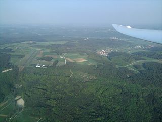
Franconian Switzerland is an upland in Upper Franconia, Bavaria, Germany and a popular tourist retreat. Located between the River Pegnitz in the east and the south, the River Regnitz in the west and the River Main in the north, its relief, which reaches 600 metres in height, forms the northern part of the Franconian Jura (Frankenjura). Like several other mountainous landscapes in the German-speaking lands, e.g. Holstein Switzerland, Märkische Schweiz, or Pommersche Schweiz, Franconian Switzerland was given its name by Romantic artists and poets in the 19th century who compared the landscape to Switzerland. Franconian Switzerland is famous for its high density of traditional breweries.

<span class="mw-page-title-main">Königsfeld, Bavaria</span> Municipality in Bavaria, Germany

Königsfeld is a community in the Upper Franconian district of Bamberg and a member of the administrative community (Verwaltungsgemeinschaft) of Steinfeld.

<span class="mw-page-title-main">Feuchtwangen</span> Town in Bavaria, Germany

Feuchtwangen is a city in Ansbach district in the administrative region of Middle Franconia in Bavaria, Germany with around 12,000 citizens and 137km² of landmass making it the biggest city in the Ansbach district by Population and Landmass. In the year 2019 Feuchtwangen celebrated its 1200th jubilee based on the first mention of its Benedictine monastery.

<span class="mw-page-title-main">Hirschaid</span> Municipality in Bavaria, Germany

Hirschaid is a German market town in the Upper Franconian district of Bamberg and lies roughly twelve kilometres south of Bamberg on the Regnitz and the Main-Danube Canal.

<span class="mw-page-title-main">Burgkunstadt</span> Town in Bavaria, Germany

Burgkunstadt is a town in the district of Lichtenfels, in northern Bavaria, Germany. It is situated on the right bank of the Main, 15 km west of Kulmbach, and 24 km southeast of Coburg.

<span class="mw-page-title-main">Ebermannstadt</span> Town in Bavaria, Germany

Ebermannstadt is a town in the district of Forchheim, in Bavaria, Germany. It is situated 10 km northeast of Forchheim and 25 km southeast of Bamberg.

<span class="mw-page-title-main">Hallstadt</span> Town in Bavaria, Germany

Hallstadt is a town in the Upper Franconian district of Bamberg on the left bank of the Main, 4 km north of Bamberg.

<span class="mw-page-title-main">Scheßlitz</span> Town in Bavaria, Germany

Scheßlitz is a German town in the Upper Franconian district of Bamberg and lies on the rise to the Franconian Switzerland on the A 70 between Bamberg and Bayreuth, lying 14 km northeast of the former.

<span class="mw-page-title-main">Breitengüßbach</span> Municipality in Bavaria, Germany

Breitengüßbach is a community in the Upper Franconian district of Bamberg. It was first mentioned as Gusibach and as belonging to the royal court at Hallstadt in an Imperial document issued between 812 and 830.

<span class="mw-page-title-main">Buttenheim</span> Town in Bavaria, Germany

Buttenheim is a market town in the Upper Franconian district of Bamberg and lies in the Regnitz Valley between Bamberg and Nuremberg, Germany.

<span class="mw-page-title-main">Memmelsdorf</span> Municipality in Bavaria, Germany

Memmelsdorf is a community in the Upper Franconian district of Bamberg bordering in the west directly on the city of Bamberg.

<span class="mw-page-title-main">Oberhaid</span> Municipality in Bavaria, Germany

Oberhaid is a community in the Upper Franconian district of Bamberg.

<span class="mw-page-title-main">Stadelhofen</span> Municipality in Bavaria, Germany

Stadelhofen is a municipality in the Upper Franconian district of Bamberg and a member of the administrative community (Verwaltungsgemeinschaft) of Steinfeld.

<span class="mw-page-title-main">Mistelgau</span> Municipality in Bavaria, Germany

Mistelgau is a municipality in the district of Bayreuth in Bavaria in Germany. The eponymous village is the seat of both the municipality as well as the municipality association Mistelgau.

Dreuschendorf is a small village located in Bavaria, Germany. It is in Upper Franconia, in the Bamberg district. Dreuschendorf is a constituent community of Buttenheim.

<span class="mw-page-title-main">Osterbrunnen</span>

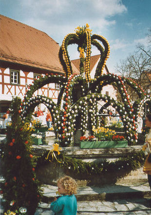
The Osterbrunnen is a German tradition of decorating public wells or fountains with Easter eggs for Easter. It began in the early 20th century in the Franconian Switzerland region of Upper Franconia but has spread to other regions. The decoration is usually kept from Good Friday until two weeks after Easter.

<span class="mw-page-title-main">Schloss Greifenstein</span> Castle in Bavaria, Germany

Schloss Greifenstein is a castle in the mountainous Fraconian Switzerland region of Upper Franconia, Germany. Since 1691 Greifenstein, the "stone stronghold" of Heiligenstadt round its walls, is the seat of the noble Schenk von Stauffenberg family. Greifenstein is a prominent feature of the modern tourist itinerary called the Burgenstraße.

<span class="mw-page-title-main">Zoggendorf</span>

Zoggendorf is a constituent community of Heiligenstadt in Oberfranken in the state of Bavaria, Germany. Its population is 110 inhabitants.

<span class="mw-page-title-main">Lange Meile</span>

The Lange Meile is a plateau in the Franconian Jura in south Germany which is up to about 517 m above sea level (NHN). It lies within the region of Franconian Switzerland in the Upper Franconian county of Forchheim in the state of Bavaria.

References

  1. Liste der ersten Bürgermeister/Oberbürgermeister in kreisangehörigen Gemeinden, Bayerisches Landesamt für Statistik, 15 July 2021.
  2. "Tabellenblatt "Daten 2", Statistischer Bericht A1200C 202041 Einwohnerzahlen der Gemeinden, Kreise und Regierungsbezirke". Bayerisches Landesamt für Statistik (in German). June 2021.
  3. Dieter Zöberlein: Gemeindechronik Markt Heiligenstadt i. OFr.
  4. Dieter Zöberlein: Gemeindechronik Markt Heiligenstadt i. OFr.
  5. Dieter Zöberlein: Gemeindechronik Markt Heiligenstadt i. OFr.
  6. Dieter Zöberlein: Gemeindechronik Markt Heiligenstadt i. OFr.

Further reading