This article needs additional citations for verification .(September 2024) |
Wattendorf | |
|---|---|
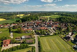 Aerial view of Wattendorf | |
 Coat of arms | |
Location of Wattendorf within Bamberg district 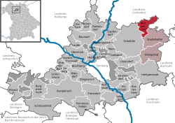 | |
 Wattendorf  Wattendorf | |
| Coordinates: 50°02′N11°08′E / 50.033°N 11.133°E | |
| Country | Germany |
| State | Bavaria |
| Admin. region | Oberfranken |
| District | Bamberg |
| Municipal assoc. | Steinfeld |
| Subdivisions | 6 Ortsteile |
| Government | |
| • Mayor (2020–26) | Thomas Betz [1] (CSU) |
| Area | |
• Total | 22.23 km2 (8.58 sq mi) |
| Elevation | 530 m (1,740 ft) |
| Population (2024-12-31) [2] | |
• Total | 632 |
| • Density | 28/km2 (74/sq mi) |
| Time zone | UTC+01:00 (CET) |
| • Summer (DST) | UTC+02:00 (CEST) |
| Postal codes | 96196 |
| Dialling codes | 09504 |
| Vehicle registration | BA |
| Website | www.wattendorf-oberfranken.de |
Wattendorf is a municipality in the Upper Franconian district of Bamberg and a member of the administrative community (Verwaltungsgemeinschaft) of Steinfeld.
