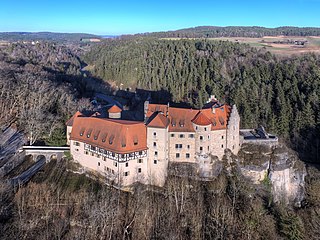
Buttenheim

Last updated
Buttenheim
Schloss Buttenheim.jpeg
Buttenheim Castle
Wappen von Buttenheim.svg
Location of Buttenheim within Bamberg district
Buttenheim in BA.svgZückshuter ForstWinkelhofer ForstSteinachsrangenSembergLindach (unincorporated area)Koppenwinder ForstHauptsmoorwaldGeisberger ForstEichwald (unincorporated area)Ebracher ForstEbracher ForstWalsdorfLauterGundelsheimKönigsfeldAltendorf
Germany adm location map.svg
Red pog.svg
Buttenheim
Bavaria location map.svg
Red pog.svg
Buttenheim
Coordinates: 49°48′15″N11°1′55″E / 49.80417°N 11.03194°E / 49.80417; 11.03194
Country Germany
State Bavaria
Admin. region Oberfranken
District Bamberg
Government
   Mayor (202026) Michael Karmann [1] (CSU)
Area
  Total30.03 km2 (11.59 sq mi)
Elevation
273 m (896 ft)
Population
 (2022-12-31) [2]
  Total3,729
  Density120/km2 (320/sq mi)
Time zone UTC+01:00 (CET)
  Summer (DST) UTC+02:00 (CEST)
Postal codes
96155
Dialling codes 09545
Vehicle registration BA
Website www.buttenheim.de

Buttenheim is a market town in the Upper Franconian district of Bamberg and lies in the Regnitz Valley between Bamberg and Nuremberg, Germany.

Contents

Buttenheim is Levi Strauss's birthplace: the future inventor of blue jeans emigrated from Germany to the United States in 1847.

Constituent communities

The market community of Buttenheim has the following constituent communities:

History

Buttenheim – "Botho's Home" – had its first documentary mention in 1017. It lies on the north-south Regnitz Valley transport axis and was probably founded about 550. During a river journey from Forchheim to Würzburg in 793, Charlemagne ordered churches to be built in the Regnitz area to convert the Slavs. It is assumed that one of Charlemagne's 14 "Slavic Churches", which were built about 800 in the Radenzgau (a county roughly corresponding to today's Upper Franconia), stood in Buttenheim.

Until the mid-17th century, Buttenheim was the most important place between Bamberg and Forchheim. Through Buttenheim ran the old trade road from Regensburg to Bamberg/Hallstadt and on to Magdeburg. Furthermore, the Saxon Road, another old connection, this one east-west, ran from the Steigerwald forest by way of Hirschaid to "Franconian Switzerland". Parts of that road are still used, having been incorporated into the modern road Staatsstraße 2260.

The Lords of Schlüsselberg, who had their first documentary mention in 1304, were resident in Buttenheim and until 1762 held an estate, the court and lordship over the village. These, however, later belonged to the Barons of Seefried. By the Act of the Confederation of the Rhine in 1806, the community passed to Bavaria.

Population development

Within municipal limits, 2,619 inhabitants were counted in 1970, 2,786 in 1987 and 3,092 in 2000. In early 2005 it was 3,442.

Politics

The community's politics is dominated by a coalition that calls itself the CSU /Zum Wohl der Gemeinde/Neue Wählergemeinschaft and furnishes the mayor. The SPD and FDP are not represented on municipal council, but instead various other voter communities are, such as Bürgerblock Gunzendorf, WG Dreuschendorf, WG Ketschendorf or WG Frankendorf.

In 1999, municipal tax revenue amounted to €1,896,000 of which business taxes (net) amounted to €789,000.

Coat of arms

Buttenheim's arms might heraldically be described thus: Party per pale, dexter party per fess argent and sable, in argent a boar spear gules per pale, sinister in argent the chief gules, thereunder a knife azure per pale.

The black and silver half of the shield is a reduced form of the arms borne by the old Lords of Stiebar, who were resident in Buttenheim. Their arms were parted and out of the parting line sprouted a Schweinsfeder ("swine's feather" – a spearlike war weapon somewhat similar to the boar spear mentioned in the blazon, which itself in German has a similar name: Saufeder, or "sow's feather") with a golden bend.

The tinctures gules and argent (red and silver) are the old Bamberg High Monastery's colours. This monastery had holdings in the community. The blue knife is an attribute of Saint Bartholomew, the patron saint of the Buttenheim church.

Culture and sightseeing

Breweries

In Buttenheim there are currently two breweries, St-Georgen-Bräu and Löwenbräu; the outlying centres of Gunzendorf and Dreuschendorf each have one brewery.

St. Bartholomew's Parish Church in Buttenheim Buttenheim Pfarrkirche.jpg
St. Bartholomew's Parish Church in Buttenheim

Parish church in Buttenheim

The Pfarrkirche St. Bartholomäus in Buttenheim was likely among the 14 "Slavic Churches" built in the Radenzgau by the Bishop of Würzburg at Charlemagne's behest.

Schloss Buttenheim

In Buttenheim, two castles were once to be found: the Oberes Schloss ("Upper Castle", also called Deichselburg) and the Unteres Schloss ("Lower Castle"). Both were owned by the Imperial Barons of Stiebar, who further owned three others in Aisch, Pretzfeld and Ermreuth. The Stiebar noble family can be traced back to 1253 and belonged to the former knighthood of the canton of Gebürg, which was under direct Imperial authority, and which stretched among Kronach, Nuremberg, Buttenheim and Kulmbach. This noble family put many abbesses, Teutonic Knights and capitulars in the High Monasteries of Bamberg and Würzburg. Between 1377 and 1560, at least fourteen members of this family were capitulars in the High Monasteries of Bamberg and Würzburg.

The Oberes Schloss (square with wall and four corner towers) was burnt down during the German Peasants' War in 1525 and never built again.

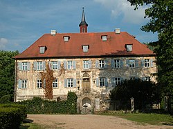
The castle that still stands today in Buttenheim is the so-called Unteres Schloss, which originally served the von Lichtenstein family as a bower, was taken over by the Stiebars, along with other pieces of real estate in Buttenheim in 1438.

The Stiebars had at their disposal in Buttenheim at that time jurisdiction over life and death, having inherited this from the von Schlüsselbergs. Under the Stiebars' ownership, the Lower Castle was burnt down several times: in 1492 in "bloody feud between Albrecht Stiebar the Younger and Prince-Bishop Heinrich III of Bamberg", in 1525 by "rebellious people from out of town" and once again in 1561 through a castle servant's carelessness when he went to bed, forgetting to put the light in his room out. Hans Joachim von Stiebar, who in 1574 was elected to the First Knightly Council (Erster Ritterrat) of the canton of Gebürg for the Bamberg and Forchheim area, thereby enjoying great prestige, repaired the damage.

The Stiebars embraced Lutheranism quite early on, as witnessed by, among other things, the appointment of an Evangelical preacher at Schloss Buttenheim, which was mentioned in a document as early as 1591.

In 1630, the Stiebars were stripped of their holdings at Imperial behest for having taken part in the Protestant Union's struggles, putting Buttenheim, and thereby the Lower Castle, under Prince Georg Ludwig von Schwarzenberg's ownership. The Stiebars, however, got their belongings back in 1648 under the Peace of Westphalia.

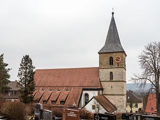
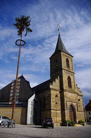
In 1741, the chapel, which still stands today, was built next to the rubble of the castle, which had been destroyed by war. The castle lords, however, had to live in a side building.

In 1762, with Imperial Baron Johann Georg Christoph Wilhelm von Stiebar's death, this noble family's main Franconian line died out. Their fiefdom went to the High Monasteries of Bamberg and Würzburg, and also partly back to the Duchy of Saxe-Coburg. Ownership stayed with the heirs, the widow and the daughters.

In 1761 the Kammerjunker (variously translated as "page" or "chamberlain") Wilhelm Christian Friedrich von Seefried wed Elisabeth Sofie von Stiebar, whom he had come to know while he was a student of jurisprudence in Erlangen. A few years later, they moved to Buttenheim. Since the Lower Castle "...had been destroyed or wiped out by fire (down to) the mediaeval, massive, square tower topped with a mansard roof...", Wilhelm Christian Friedrich von Seefried built the current Baroque castle in 1774 onto the one tower that still stood, and in which is still found the Evangelical castle chapel.

Wilhelm Christian saw to it that the Evangelical castle parish was newly confirmed. In 1790, Wilhelm Christian, who had set himself all his life to strengthening the Evangelical faith, was raised to the Imperial Barony. In 1814, a "Protestant castle parish" from the "Castle Chaplaincy" was consecrated, and on 27 August 1826, the castle chapel was consecrated as a communal House of God.

Even today, the castle chapel still serves the Buttenheim Evangelical parish, which since that time has been put in the care of the parish of Hirschaid, as a House of God.

Since Wilhelm Christian's time, the castle has been occupied almost uninterruptedly by his descendants.

Curacy Church in Gunzendorf

From the Baroque Kuratie-Kirche St. Nikolaus begins the Georgiritt (roughly "George's Ride") to the Senftenberg, a nearby mountain.

Senftenberg with St. George's Chapel

The Baroque community chapel of St. George on the Senftenberg is the destination of the Georgiritt.

"Golden Village" of Frankendorf with climbing park

Frankendorf, a village of timber-frame houses, became the winner of the contest Unser Dorf soll schöner werden ("Our village ought to become lovelier") in 1981. The district evaluation jury came to this conclusion in 1980:

The almost fully preserved timber-frame ensemble with its 31 one-floor farmers houses under memorial protection is without peer in Upper Franconia.

It goes on to say:

The townsfolk's community spirit and readiness to sacrifice were always exemplary for the district.

About the landscape, this was stated:

Orchards green the place in exemplary fashion; the valley is covered with groves of trees. The transition to free landscape is fluid.

Levi-Strauss-Museum

Levi-Strauss-Museum Buttenheim Levi Strauss Haus.jpg
Levi-Strauss-Museum

Levi Strauss, the inventor of blue jeans was born in Buttenheim on 26 February 1829 as Löb Strauß. The house where he was born is now a museum. Built in 1687, the timber-frame structure was expanded in 1733 to house two families. Among the permanent exhibits can be seen the Strauss family's emigration documents and the publication of their emigration in the official journal.

Museums

The Kleines Haus der Kunst ("Little House of Art") shows paintings, graphics, sculpture and photographs by Eastern European artists.

Regular events

Georgiritt Hl.Georg.jpg
Georgiritt

The tradition-rich Georgiritt takes place on 23 April (Saint George's Day) and leads from Gunzendorf up onto the Senftenberg. This is a kind of pilgrimage to Saint George traditionally done on horseback.

Economy and infrastructure

According to official statistics, there were 334 workers on the social welfare contribution rolls working in producing businesses in 1998, and in trade and transport 267. In other areas, 104 workers on the social welfare contribution rolls were employed, and 1,139 such workers worked from home. In processing businesses there were no businesses, and in construction three. Furthermore, in 1999, there were 75 agricultural operations with a working area of 1 661 ha, of which 1 226 ha was cropland and 429 ha was meadowland.

Transport

Buttenheim lies right on Bundesautobahn 73 with its own interchange and on the Bamberg–Nuremberg railway line with its own station.

Telecommunications

The 142-meter-tall Deutsche Telekom AG transmission tower, built in 1973 ( 49°51′10″N11°3′37″E / 49.85278°N 11.06028°E / 49.85278; 11.06028 ), stands on the Sommeranger Berg.

Education

In 1999, the following institutions existed in Buttenheim:

Famous people

Related Research Articles

<span class="mw-page-title-main">Forchheim</span> Town in Bavaria, Germany

Forchheim is a town in Upper Franconia in northern Bavaria, and also the seat of the administrative district of Forchheim. Forchheim is a former royal city, and is sometimes called the Gateway to the Franconian Switzerland, referring to the region of outstanding natural beauty to the north east of the town. Nowadays Forchheim is most famous for its ten day long beer and music festival (Annafest) which takes place in late July in an idyllic wooded hillside, home to 24 beer gardens, on the outskirts of the town. Forchheim's population, as of December 2013, was 30,705, and its land area is 44.95 square kilometres. Its position is 49° 44' N, 11° 04' E and its elevation is 265 metres above sea level.

The House of Schönborn is the name of an ancient noble and mediatised formerly sovereign family of the former Holy Roman Empire.

<span class="mw-page-title-main">Franconian Switzerland</span> Upland in the German state of Bavaria

Franconian Switzerland is an upland in Upper Franconia, Bavaria, Germany and a popular tourist retreat. Located between the River Pegnitz in the east and the south, the River Regnitz in the west and the River Main in the north, its relief, which reaches 600 metres in height, forms the northern part of the Franconian Jura (Frankenjura). Like several other mountainous landscapes in the German-speaking lands, e.g. Holstein Switzerland, Märkische Schweiz, or Pommersche Schweiz, Franconian Switzerland was given its name by Romantic artists and poets in the 19th century who compared the landscape to Switzerland. Franconian Switzerland is famous for its high density of traditional breweries.

<span class="mw-page-title-main">Hirschaid</span> Municipality in Bavaria, Germany

Hirschaid is a German market town in the Upper Franconian district of Bamberg and lies roughly twelve kilometres south of Bamberg on the Regnitz and the Main-Danube Canal.

<span class="mw-page-title-main">Ebermannstadt</span> Town in Bavaria, Germany

Ebermannstadt is a town in the district of Forchheim, in Bavaria, Germany. It is situated 10 km northeast of Forchheim and 25 km southeast of Bamberg.

<span class="mw-page-title-main">Schlüsselfeld</span> Town in Bavaria, Germany

Schlüsselfeld is a town on the southwestern edge of the Upper Franconian district (Landkreis) of Bamberg

<span class="mw-page-title-main">Bibra family</span>

The House of Bibra was one of the leading Uradel families in Franconia and present day Thuringia from the mid-15th century to about 1600. Later on the family rose from Reichsritter to Reichsfreiherr. After the Holy Roman Empire dissolved, they were made ‘’Freiherr’‘ (Barons) of Bavaria and Bohemia.

<span class="mw-page-title-main">Altendorf, Upper Franconia</span> Municipality in Bavaria, Germany

Altendorf is a community in the Upper Franconian district of Bamberg, Bavaria, Germany.

<span class="mw-page-title-main">Bischberg</span> Municipality in Bavaria, Germany

Bischberg is a community in the Upper Franconian district of Bamberg lying at the forks of the rivers Regnitz and Main some 5 km west of Bamberg.

<span class="mw-page-title-main">Kemmern</span> Municipality in Bavaria, Germany

Kemmern is a community in the Upper Franconian district of Bamberg in Bavaria, southern Germany.

<span class="mw-page-title-main">Prince-Bishopric of Bamberg</span> Ecclesiastical State of the Holy Roman Empire

The Prince-Bishopric of Bamberg was an ecclesiastical State of the Holy Roman Empire. It goes back to the Roman Catholic Diocese of Bamberg established at the 1007 synod in Frankfurt, at the behest of King Henry II to further expand the spread of Christianity in the Franconian lands. The bishops obtained the status of Imperial immediacy about 1245 and ruled their estates as Prince-bishops until they were subsumed to the Electorate of Bavaria in the course of the German Mediatisation in 1802.

<span class="mw-page-title-main">Princess Elisabeth Marie of Bavaria</span> Countess Otto of Seefried and Buttenheim

Princess Elisabeth Marie of Bavaria was a member of the Bavarian Royal House of Wittelsbach

Dreuschendorf is a small village located in Bavaria, Germany. It is in Upper Franconia, in the Bamberg district. Dreuschendorf is a constituent community of Buttenheim.

<span class="mw-page-title-main">Nuremberg–Bamberg railway</span> German railway line

The Nuremberg-Bamberg line is a German railway connecting the Bavarian city of Nuremberg with Bamberg via Fürth, Erlangen, Forchheim. It is part of the northern section of the Ludwig South-North Railway. It runs along the Regnitz Valley and is one of the important German transport routes. Since 2010 line S1 of the Nuremberg S-Bahn uses the entirety of the line from Nuremberg to Bamberg.

<span class="mw-page-title-main">Steigerwald</span> Hill region in Germany

The Steigerwald is a hill region up to 498.5 m above sea level (NHN) in the Bavarian-Franconian part of the South German Scarplands between Würzburg and Nuremberg. It is part of the Keuper Uplands, and within it, it is continued to the north-northeast and right of the river Main, by the Haßberge, and to the south-southwest by the Franconian Heights. Part of the region is a designated as the Steigerwald Nature Park.

<span class="mw-page-title-main">Wichsenstein Castle</span>

Wichsenstein Castle was a hill castle, once owned by noblemen, on a steep and prominent rock reef (Felsriff) outcrop above the church village of Wichsenstein in the Upper Franconian county of Forchheim in Bavaria, Germany. The castle has been completely demolished and there are no visible remains. The castle rock is now just used as a viewing point.

Gunzendorf is a small village located in Bavaria, Germany. It is in Upper Franconia, in the Bamberg district. Gunzendorf is a constituent community of Buttenheim.

<span class="mw-page-title-main">Kohlstein Castle</span>

Kohlstein Castle is situated on a rocky hillock in the village of Kohlstein northwest of Tüchersfeld and is the most recently built castle in Franconian Switzerland. It is also one of the smallest and most romantic castles. Today it is in private ownership and may not be visited.

<span class="mw-page-title-main">Neideck Castle</span> Castle in Germany

Neideck Castle is a former high mediaeval nobleman's castle above the village of Streitberg, in the municipality of Wiesenttal in the Upper Franconian county of Forchheim in the German state of Bavaria. As a result of its exposed location above the valley of the Wiesent, it has become a symbol of Franconian Switzerland.

<span class="mw-page-title-main">Rabenstein Castle (Upper Franconia)</span> Castle in Germany

Rabenstein Castle is a former high medieval aristocratic castle in the municipality of Ahorntal in the Upper Franconian county of Bayreuth in the German state of Bavaria.

References

Further reading