Stadelhofen

Last updated
Stadelhofen
Stadelhofen Ortsmitte.JPG
Center of the municipality with the Church of Saints Peter and Paul
DEU Stadelhofen COA.svg
Coat of arms
Location of Stadelhofen within Bamberg district
Stadelhofen in BA.svg
Germany adm location map.svg
Red pog.svg
Stadelhofen
Bavaria location map.svg
Red pog.svg
Stadelhofen
Coordinates: 50°0′N11°2′E / 50.000°N 11.033°E / 50.000; 11.033 Coordinates: 50°0′N11°2′E / 50.000°N 11.033°E / 50.000; 11.033
Country Germany
State Bavaria
Admin. region Oberfranken
District Bamberg
Municipal assoc. Steinfeld
Subdivisions10 Ortsteile
Government
   Mayor Ludwig Göhl
Area
  Total41.01 km2 (15.83 sq mi)
Elevation
478 m (1,568 ft)
Population
 (2017-12-31) [1]
  Total1,242
  Density30/km2 (78/sq mi)
Time zone CET/CEST (UTC+1/+2)
Postal codes
96187
Dialling codes 09504
Vehicle registration BA
Website www.stadelhofen-oberfranken.de

Stadelhofen is a municipality in the Upper Franconian (German: Oberfranken) district of Bamberg and a member of the administrative community (Verwaltungsgemeinschaft) of Steinfeld.

Upper Franconia Regierungsbezirk in Bavaria, Germany

Upper Franconia is a Regierungsbezirk of the state of Bavaria, southern Germany. It forms part of the historically significant region of Franconia, all now part of the German Federal State of Bayern (Bavaria).

Bamberg (district) District in Bavaria, Germany

Bamberg is a Landkreis (district) in Bavaria, Germany. It surrounds but does not include the town of Bamberg. The district is bounded by the districts of Lichtenfels, Bayreuth, Forchheim, Erlangen-Höchstadt, Neustadt (Aisch)-Bad Windsheim, Kitzingen, Schweinfurt and Haßberge.

Contents

Geography

The community lies on the edge of the “Franconian Switzerland” on the Autobahn from Bamberg to Bayreuth.

Franconian Switzerland geographic region

Franconian Switzerland is an upland in Upper Franconia, Bavaria, Germany, and a popular tourist retreat. Located between the River Pegnitz in the east and the south, the River Regnitz in the west and the River Main in the north, its relief, which reaches 600 metres in height, forms the northern part of the Franconian Jura (Frankenjura). As several other mountainous landscapes in the German-speaking lands, e.g. Holstein Switzerland, Märkische Schweiz, or Pommersche Schweiz, Franconian Switzerland was given its name by Romantic artists and poets in the 19th century who compared the landscape to Switzerland. The Franconian Switzerland is famous for its high density of traditional breweries.

Autobahn national expressway in Germany

The AutobahnIPA: [ˈʔaʊtoˌba:n](listen), German plural Autobahnen) is the federal controlled-access highway system in Germany. The official German term is Bundesautobahn, which translates as "federal motorway". The literal meaning of the word Bundesautobahn is "Federal Auto(mobile) Track".

Bayreuth Place in Bavaria, Germany

Bayreuth is a medium-sized city in northern Bavaria, Germany, on the Red Main river in a valley between the Franconian Jura and the Fichtelgebirge Mountains. The town's roots date back to 1194. In the early 21st century, it is the capital of Upper Franconia and has a population of 72,148 (2015). It is world-famous for its annual Bayreuth Festival, at which performances of operas by the 19th-century German composer Richard Wagner are presented.

Constituent communities

Stadelhofen’s namesake centre is not the biggest of its Gemeindeteile with Steinfeld being more than twice its size. The community has these centres, each given here with its own population figure: [2]

  • Steinfeld (383)
  • Stadelhofen (185)
  • Schederndorf (147)
  • Eichenhüll (108)
  • Wölkendorf (103)
  • Pfaffendorf (102)
  • Hohenhäusling (80)
  • Roßdorf am Berg (71)
  • Wotzendorf (54)
  • Hopfenmühle (5)

The community also has 5 traditional rural land units, known in German as Gemarkungen, named Hohenhäusling, Schederndorf, Stadelhofen, Steinfeld and Wölkendorf, four of which have the same names as four of the constituent communities (it is traditional for a Gemarkung to be named after a town or village lying nearby).

German language West Germanic language

German is a West Germanic language that is mainly spoken in Central Europe. It is the most widely spoken and official or co-official language in Germany, Austria, Switzerland, South Tyrol in Italy, the German-speaking Community of Belgium, and Liechtenstein. It is also one of the three official languages of Luxembourg and a co-official language in the Opole Voivodeship in Poland. The languages which are most similar to German are the other members of the West Germanic language branch: Afrikaans, Dutch, English, the Frisian languages, Low German/Low Saxon, Luxembourgish, and Yiddish. There are also strong similarities in vocabulary with Danish, Norwegian and Swedish, although those belong to the North Germanic group. German is the second most widely spoken Germanic language, after English.

History

The community had its first documentary mention in 1248. The placename Stadelhofen is believed to mean “at the farms furnished with a barn”. However, it could also have come from a corrupted personal name.

Stadelhofen lies at the spot where an old army road from Bamberg to Kulmbach once crossed the way from Weismain to Hollfeld.

Kulmbach Place in Bavaria, Germany

Kulmbach is the capital of the district of Kulmbach in Bavaria in Germany. The town is famous for Plassenburg Castle, which houses the largest tin soldier museum in the world, and for its famous sausages, or Bratwürste.

Weismain Place in Bavaria, Germany

Weismain is a town in the district of Lichtenfels, in northern Bavaria, Germany. It is situated 15 km west of Kulmbach, and 15 km southeast of Lichtenfels.

Hollfeld Place in Bavaria, Germany

Hollfeld is a town in the district of Bayreuth, in Bavaria, Germany.

Source of the Wiesent in Steinfeld SourceWiesentSteinfeld.JPG
Source of the Wiesent in Steinfeld

Even if Stadelhofen had its first documentary mention rather late, it is clear that the area was already settled by the year 630. On a map from 1595, the area around Stadelhofen bears the description Uf dem Gebürg.

In 1386, the Counts of Truhendingen sold the place at a price of 2,000 heller to the Bishop of Bamberg. Since the Reichsdeputationshauptschluss of 1803, before which the community had belonged to the High Monastery at Bamberg, Stadelhofen has belonged to Bavaria. In the course of administrative reform in Bavaria, today’s community came into being under the Gemeindeedikt (“Community Edict”) of 1818. Since 1978, the community has consisted of the formerly autonomous communities of Stadelhofen, Wölkendorf, Schederndorf and Steinfeld.

Heller (money)

The Heller or Häller , originally a German coin valued at half a pfennig, took its name from the city of Hall am Kocher.

<i lang="de" title="German language text">Reichsdeputationshauptschluss</i>

The Reichsdeputationshauptschluss, sometimes referred to in English as the Final Recess or the Imperial Recess of 1803, was a resolution passed by the Reichstag of the Holy Roman Empire on 24 March 1803. It was ratified by the Emperor Francis II and became law on 27 April. It proved to be the last significant law enacted by the Empire before its dissolution in 1806.

Bavaria State in Germany

Bavaria, officially the Free State of Bavaria, is a landlocked federal state of Germany, occupying its southeastern corner. With an area of 70,550.19 square kilometres, Bavaria is the largest German state by land area comprising roughly a fifth of the total land area of Germany. With 13 million inhabitants, it is Germany's second-most-populous state after North Rhine-Westphalia. Bavaria's main cities are Munich, Nuremberg and Augsburg.

Besides Stadelhofen there was also once in the area a now lost parish called Leuchnitz, which lay somewhere between Weismain and Steinfeld.

The Catholic parish church, consecrated to Saint Peter and Saint Catherine, comes from the 18th century. The tower with its pointed cupola is one of the area’s landmarks. The high altar was bought in 1721 from the people in Litzendorf.

Population development

Within municipal limits, 1404 inhabitants were counted in 1970, 1291 in 1987 and 1274 in 2000. In 2004-2005 it was 1200.

Politics

The mayor is Ludwig Göhl (Überparteiliche Wählergemeinschaft). He succeeded Heinrich Linz (CSU) in 2002.

Municipal election 2002

At the 2002 municipal election, the Überparteiliche Wählergemeinschaft voters’ group won 6 seats (49.7%), the CSU won 3 (26.6%) and the Freie Wähler won 3 (23.7%). Voter turnout was 90.1%.

In 1999, municipal tax revenue, converted to euros, amounted to €382,000 of which business taxes (net) amounted to €37,000.

Coat of arms

Stadelhofen’s arms might heraldically be described thus: Party per pale Or and azure, Or a fess gules, thereover a chess-rook argent, azure a fess argent, thereover a rose with button Or and sepals vert.

The charge described above as a “chess-rook” – even though it looks nothing like the rooks seen on a chessboard [3] – is called a Doppelspringer in German, and presumably the sense of “knight” is to be understood. This charge recalls the Neustätter family. The red fess (horizontal bar) on the golden field refers to the Counts of Truhendingen. The rose is from the arms borne by the Lords of Aufseß. The tinctures gules and argent (red and silver) refer to the Giech and Förtsch families, who were ministeriales to the Counts of Andechs-Merania.

Old map by Sebastian Rotenhan with Stadelhofen (Stadelhoven) Francia OrientalisSebastian Rotenhan.jpg
Old map by Sebastian Rotenhan with Stadelhofen (Stadelhoven)

Economy and infrastructure

According to official statistics, there were 61 workers on the social welfare contribution rolls working in producing businesses, and in trade and transport none. In other areas, 30 workers on the social welfare contribution rolls were employed, and 468 such workers worked from home. In processing businesses there were 5 businesses, and in construction 1. Furthermore, in 1999, there were 138 agricultural operations with a working area of 2 286 ha, of which 2 043 ha was cropland and 242 ha was meadowland.

Breweries

Within municipal limits are found today two breweries, the Brauerei Will in Schederndorf and the Brauerei Hübner in Steinfeld. Until 1985, there was also the Brauerei Schrenker in Stadelhofen.

Education

In 1999, the following institutions existed in Stadelhofen:

Related Research Articles

Königsfeld, Bavaria Place in Bavaria, Germany

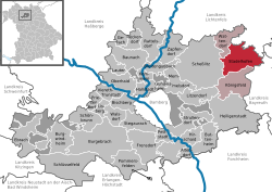
Königsfeld is a community in the Upper Franconian district of Bamberg and a member of the administrative community (Verwaltungsgemeinschaft) of Steinfeld.

Wattendorf Place in Bavaria, Germany

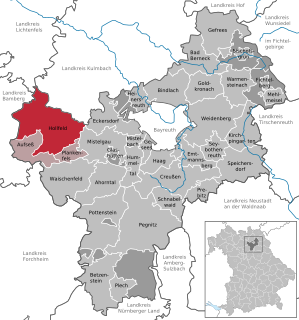
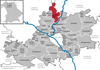
Wattendorf is the smallest community in the Upper Franconian district of Bamberg and a member of the administrative community (Verwaltungsgemeinschaft) of Steinfeld.

Krombach, Bavaria Place in Bavaria, Germany

Krombach is a community in the Aschaffenburg district in the Regierungsbezirk of Lower Franconia (Unterfranken) in Bavaria, Germany and a member of the Verwaltungsgemeinschaft of Schöllkrippen.

Altendorf, Upper Franconia Place in Bavaria, Germany

Altendorf is a community in the Upper Franconian district of Bamberg, Bavaria, Germany.

Breitengüßbach Place in Bavaria, Germany

Breitengüßbach is a community in the Upper Franconian district of Bamberg. It was first mentioned as Gusibach and as belonging to the royal court at Hallstadt in an Imperial document issued between 812 and 830.

Ebrach Place in Bavaria, Germany

Ebrach is a community with market rights in the Upper Franconian district of Bamberg and the seat of the Verwaltungsgemeinschaft of Ebrach.

Gundelsheim, Bavaria Place in Bavaria, Germany

Gundelsheim is a community in the Upper Franconian district of Bamberg.

Lauter, Bavaria Place in Bavaria, Germany

Lauter is a community in the Upper Franconian district of Bamberg and a member of the administrative community (Verwaltungsgemeinschaft) of Baunach.

Pettstadt Place in Bavaria, Germany

Pettstadt is a community in the Upper Franconian district of Bamberg with about 1,900 inhabitants.

Pommersfelden Place in Bavaria, Germany

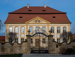
Pommersfelden is a community in the Upper Franconian district of Bamberg in Germany.

Priesendorf Place in Bavaria, Germany

Priesendorf is a community in the Upper Franconian district of Bamberg and a member of the administrative community (Verwaltungsgemeinschaft) of Lisberg.

Rattelsdorf Place in Bavaria, Germany

Rattelsdorf is a community with market rights in the Upper Franconian district of Bamberg.

Zapfendorf Place in Bavaria, Germany

Zapfendorf is a community with market rights in the Upper Franconian district of Bamberg in Bavaria, Germany with roughly 5,000 inhabitants.

Gräfendorf Place in Bavaria, Germany

Gräfendorf is a community in the Main-Spessart district in the Regierungsbezirk of Lower Franconia (Unterfranken) in Bavaria, Germany and a member of the Verwaltungsgemeinschaft of Gemünden am Main.

Hafenlohr Place in Bavaria, Germany

Hafenlohr is a community in the Main-Spessart district in the Regierungsbezirk of Lower Franconia (Unterfranken) in Bavaria, Germany and a member of the Verwaltungsgemeinschaft of Marktheidenfeld.

Himmelstadt Place in Bavaria, Germany

Himmelstadt is a community in the Main-Spessart district in the Regierungsbezirk of Lower Franconia (Unterfranken) in Bavaria, Germany and a member of the Verwaltungsgemeinschaft of Zellingen.

Karbach, Bavaria Place in Bavaria, Germany

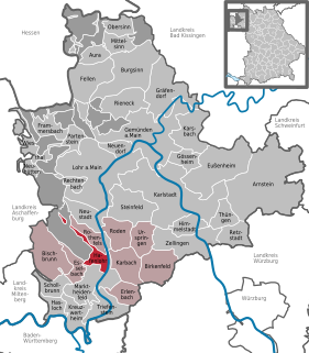
Karbach is a market community in the Main-Spessart district in the Regierungsbezirk of Lower Franconia (Unterfranken) in Bavaria, Germany and a member of the Verwaltungsgemeinschaft of Marktheidenfeld.

Steinfeld, Bavaria Place in Bavaria, Germany

Steinfeld is a community in the Main-Spessart district in the Regierungsbezirk of Lower Franconia (Unterfranken) in Bavaria, Germany and a member of the Verwaltungsgemeinschaft of Lohr am Main.

Zellingen Place in Bavaria, Germany

Zellingen is a market community in the Main-Spessart district in the Regierungsbezirk of Lower Franconia (Unterfranken) in Bavaria, Germany and the seat of the Verwaltungsgemeinschaft of Zellingen.

Eichenbühl Place in Bavaria, Germany

Eichenbühl is a community in the Miltenberg district in the Regierungsbezirk of Lower Franconia (Unterfranken) in Bavaria, Germany.

References

  1. "Fortschreibung des Bevölkerungsstandes". Bayerisches Landesamt für Statistik und Datenverarbeitung (in German). September 2018.
  2. Mitteilungsblatt der Verwaltungsgemeinschaft Steinfeld vom 23. Januar 2015
  3. "A Glossary Of Terms Used In Heraldry By James Parker". Heraldsnet.org. Retrieved 2015-12-17.