Altendorf, Upper Franconia

Last updated
Altendorf
Seussling Kirche 030112.jpg
Church of Saint Sigismund in Seußling
Wappen von Altendorf (Oberfranken).svg
Coat of arms
Location of Altendorf within Bamberg district
Altendorf in BA.svg
Germany adm location map.svg
Red pog.svg
Altendorf
Bavaria location map.svg
Red pog.svg
Altendorf
Coordinates: 49°48′N11°1′E / 49.800°N 11.017°E / 49.800; 11.017 Coordinates: 49°48′N11°1′E / 49.800°N 11.017°E / 49.800; 11.017
Country Germany
State Bavaria
Admin. region Oberfranken
District Bamberg
Government
   Mayor (202026) Karl-Heinz Wagner [1] (CSU)
Area
  Total8.61 km2 (3.32 sq mi)
Elevation
251 m (823 ft)
Population
 (2020-12-31) [2]
  Total2,111
  Density250/km2 (640/sq mi)
Time zone UTC+01:00 (CET)
  Summer (DST) UTC+02:00 (CEST)
Postal codes
96146
Dialling codes 09545
Vehicle registration BA
Website www.altendorf-gemeinde.de

Altendorf is a community in the Upper Franconian district of Bamberg, Bavaria, Germany.

Contents

Geography

Altendorf lies in the Oberfranken-West (Upper Franconia West) Region.

Constituent communities

The namesake centre of Altendorf has 1,544 inhabitants while the outlying amalgamated centre of Seußling (or Seussling) has 542 (as of 1 January 2003).

The community also has two traditional rural land units, known in German as Gemarkungen, also named Altendorf and Seußling (it is traditional for a Gemarkung to be named after a town or village lying nearby).

History

Before Secularization, Altendorf belonged to the High Monastery at Bamberg. Since the Reichsdeputationshauptschluss of 1803, the community has belonged to Bavaria. In the course of administrative reform in Bavaria, today's community came into being under the Gemeindeedikt (“Community Edict”) of 1818.

Many finds from Celtic times point to early settlement. While Altendorf was first mentioned as a Slavic round village in 1096, the outlying centre of Seußling had already been mentioned as a church village by 800. Here stood one of Charlemagne’s 14 Slavic churches (Slavenkirchen). Seußling's parochial area reached well into the Steigerwald (forest).

Religion

The Catholic church in Altendorf is affiliated with Sankt Bartholomäus, Buttenheim . Also within the community is the Catholic parish of Sankt-Sigismund Seußling.

The parish church of St. Sigismund received its patronage when Charles IV, Holy Roman Emperor had the saint's bones transferred from Saint-Maurice in the Swiss canton of Valais to Prague. The shrine was also set down in Seußling, holding one of the dead king's arms as a relic in the parish church.

Denominational breakdown of the inhabitants:

Population development

Within community limits, 1,274 inhabitants were counted in 1970, 1,542 in 1987 and 2,006 in 2000. In June 2007, 1,963 people lived in Altendorf.

The population growth between 1961 and 1971 amounted to 80% owing to the community's favourable location for transport links and widespread building development.

Politics

The mayor is Karl-Heinz Wagner of the CSU.

The community council is made up of 14 members, listed here by party or voter community affiliation, and also with the number of seats that each holds, since the 2020 local elections: [3]

Coat of arms

Altendorf's arms might heraldically be described thus: Under the chief gules, therein a key argent per fess the bit downturned, in Or a horse trippant sable.

The German blazon, however, does not mention that the horse is trippant (standing with one forefoot raised), nor does it mention that the key's bit is downturned, but the arms are usually so executed.

The black horse is already seen on a silver coin found in the lands settled by the Celts and believed to have been struck about 80 BC. The silver key in the chief (band at the top of a coat of arms) refers to the connection to the old noble family of Schlüsselberg (“Schlüssel” literally means “key” in German).

Economy and infrastructure

According to official statistics, there were no workers on the social welfare contribution rolls working in agriculture or forestry in 1998. In producing businesses there were 616, and in trade and transport 19. In other areas, 17 workers on the social welfare contribution rolls are employed, and 689 such workers work from home. Seven employed in processing businesses (as well as mining and quarrying). Four businesses are in construction, and furthermore, in 1999, there were 19 agricultural operations with a working area of 393 ha, of which 329 ha was cropland and 64 ha was meadowland.

Education

In 1999, the following institutions existed in Altendorf:

Related Research Articles

Wattendorf Place in Bavaria, Germany

Wattendorf is the smallest community in the Upper Franconian district of Bamberg and a member of the administrative community (Verwaltungsgemeinschaft) of Steinfeld.

Hallstadt Place in Bavaria, Germany

Hallstadt is a town in the Upper Franconian district of Bamberg on the left bank of the Main, 4 km north of Bamberg.

Schlüsselfeld Place in Bavaria, Germany

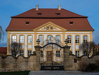
Schlüsselfeld is a town on the southwestern edge of the Upper Franconian district of Bamberg

Bischberg Place in Bavaria, Germany

Bischberg is a community in the Upper Franconian district of Bamberg lying at the forks of the rivers Regnitz and Main some 5 km west of Bamberg.

Breitengüßbach Place in Bavaria, Germany

Breitengüßbach is a community in the Upper Franconian district of Bamberg. It was first mentioned as Gusibach and as belonging to the royal court at Hallstadt in an Imperial document issued between 812 and 830.

Burgebrach Place in Bavaria, Germany

Burgebrach is a market town in the Upper Franconian district of Bamberg and the seat of the administrative community (Verwaltungsgemeinschaft) of Burgebrach.

Burgwindheim Place in Bavaria, Germany

Burgwindheim is a municipality with market rights in the west of the Upper Franconian district of Bamberg and a member of the administrative community (Verwaltungsgemeinschaft) of Ebrach.

Ebrach Place in Bavaria, Germany

Ebrach is a community with market rights in the Upper Franconian district of Bamberg and the seat of the Verwaltungsgemeinschaft of Ebrach.

Frensdorf Place in Bavaria, Germany

Frensdorf is a community in the Upper Franconian district of Bamberg.

Gerach Place in Bavaria, Germany

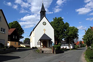
Gerach is a community in the Upper Franconian district of Bamberg and a member of the administrative community (Verwaltungsgemeinschaft) of Baunach. It lies in the Naturpark Haßberge roughly 20 km north of Bamberg and roughly 10 km south of Ebern.

Gundelsheim, Bavaria Place in Bavaria, Germany

Gundelsheim is a community in the Upper Franconian district of Bamberg.

Oberhaid Place in Bavaria, Germany

Oberhaid is a community in the Upper Franconian district of Bamberg.

Pettstadt Place in Bavaria, Germany

Pettstadt is a community in the Upper Franconian district of Bamberg with about 1,900 inhabitants.

Priesendorf Place in Bavaria, Germany

Priesendorf is a community in the Upper Franconian district of Bamberg and a member of the administrative community (Verwaltungsgemeinschaft) of Lisberg.

Rattelsdorf Place in Bavaria, Germany

Rattelsdorf is a community with market rights in the Upper Franconian district of Bamberg.

Schönbrunn im Steigerwald Place in Bavaria, Germany

Schönbrunn im Steigerwald is a community in the Upper Franconian district of Bamberg and a member of the administrative community (Verwaltungsgemeinschaft) of Burgebrach.

Stadelhofen Place in Bavaria, Germany

Stadelhofen is a municipality in the Upper Franconian district of Bamberg and a member of the administrative community (Verwaltungsgemeinschaft) of Steinfeld.

Strullendorf Place in Bavaria, Germany

Strullendorf is a community in the Upper Franconian district of Bamberg.

Viereth-Trunstadt Place in Bavaria, Germany

Viereth-Trunstadt is a community in the Upper Franconian district of Bamberg lying on the Main.

Zapfendorf Place in Bavaria, Germany

Zapfendorf is a community with market rights in the Upper Franconian district of Bamberg in Bavaria, Germany with roughly 5,000 inhabitants.

References

  1. Liste der ersten Bürgermeister/Oberbürgermeister in kreisangehörigen Gemeinden, Bayerisches Landesamt für Statistik, 15 July 2021.
  2. "Tabellenblatt "Daten 2", Statistischer Bericht A1200C 202041 Einwohnerzahlen der Gemeinden, Kreise und Regierungsbezirke". Bayerisches Landesamt für Statistik und Datenverarbeitung (in German). June 2021.
  3. KoW 2020: Ergebnis der Gemeinderatswahlen in Oberfranken (kreisangehörige Gemeinden), Bayerisches Landesamt für Statistik, accessed 26 July 2021.