Lisberg

Last updated
Lisberg
Lisberg-4265133.jpg
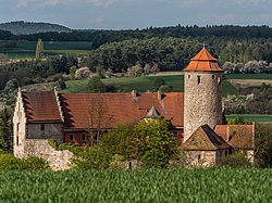
Lisberg Castle
DEU Lisberg COA.svg
Coat of arms
Location of Lisberg within Bamberg district
Lisberg in BA.svg
Germany adm location map.svg
Red pog.svg
Lisberg
Bavaria location map.svg
Red pog.svg
Lisberg
Coordinates: 49°52′03″N10°47′22″E / 49.86750°N 10.78944°E / 49.86750; 10.78944 Coordinates: 49°52′03″N10°47′22″E / 49.86750°N 10.78944°E / 49.86750; 10.78944
Country Germany
State Bavaria
Admin. region Oberfranken
District Bamberg
Municipal assoc. Lisberg
Subdivisions4 Ortsteile
Government
   Mayor Michael Bergrab
Area
  Total8.36 km2 (3.23 sq mi)
Highest elevation
384 m (1,260 ft)
Lowest elevation
288 m (945 ft)
Population
 (2019-12-31) [1]
  Total1,716
  Density210/km2 (530/sq mi)
Time zone UTC+01:00 (CET)
  Summer (DST) UTC+02:00 (CEST)
Postal codes
96170
Dialling codes 09549
Vehicle registration BA
Website www.lisberg.de

Lisberg is a community in Bavaria, Germany. It is in the Upper Franconian district of Bamberg and a member of the administrative community (Verwaltungsgemeinschaft) of Lisberg, lying in the Steigerwald (forest).

Contents

Geography

Lisberg lies west of Bamberg.

Constituent communities

Lisberg’s main and namesake centre is the biggest of its Ortsteile , although Trabelsdorf is not much smaller. The community has these centres, each given here with its own population figure:

The community also has 2 traditional rural land units, known in German as Gemarkungen, named Lisberg and Trabelsdorf, the same names as 2 of the constituent communities (it is traditional for a Gemarkung to be named after a town or village lying nearby).

History

Lisberg is noticeable even from far away for the Burg Lisberg. This castle had its first documentary mention in 820 in a donation document, and it is among Germany’s oldest undestroyed castles. From 1600 to 1707, the Protestant line of the Barons of Münster held Lisberg as a fief, and then until 1790 the Catholic line did so. The castle is now privately owned. Concerts are sometimes held in the castle’s courtyard.

The palatial residence (Schloss) in the outlying centre of Trabelsdorf was acquired in 1664 by the Marshals of Ostheim and in 1700 it was newly built. It now houses the administrative community (Verwaltungsgemeinschaft) of Lisberg (whose member communities are Lisberg and Priesendorf) and a medical practice.

With the Act of the Confederation of the Rhine in 1806, the Barons of Münster-Lisberg saw their overlordship pass to Bavaria. The community of Lisberg has existed since 1978, consisting of the two formerly autonomous communities of Lisberg and Trabelsdorf.

South of Lisberg can be found a Jewish graveyard on a plot of higher ground with some 130 gravestones. In Lisberg, about 1825, there were 17 Jewish families. The number had shrunk so sharply by the early 20th century, however, that the synagogue was sold.

Politics

Lisberg’s municipal council consists of 12 members besides the mayor, 6 of whom likewise belong to the ÜPL, and the other 6 of whom are CSU members.

In 1999, municipal tax revenue, converted to euros, amounted to €640,000 of which business taxes (net) amounted to €115,000.

Culture and sport

Lisberg is regularly the venue for the so-called Donnersbergklassiker (“Thunder Mountain Classic”), a cycling race around the Steigerwald (forest).

Notable people

Related Research Articles

Stegaurach Place in Bavaria, Germany

Stegaurach is a community in the Upper Franconian district of Bamberg and the seat of the administrative community (Verwaltungsgemeinschaft) of Stegaurach.

Schlüsselfeld Place in Bavaria, Germany

Schlüsselfeld is a town on the southwestern edge of the Upper Franconian district of Bamberg

Altendorf, Upper Franconia Place in Bavaria, Germany

Altendorf is a community in the Upper Franconian district of Bamberg, Bavaria, Germany.

Burgebrach Place in Bavaria, Germany

Burgebrach is a market town in the Upper Franconian district of Bamberg and the seat of the administrative community (Verwaltungsgemeinschaft) of Burgebrach.

Burgwindheim Place in Bavaria, Germany

Burgwindheim is a municipality with market rights in the west of the Upper Franconian district of Bamberg and a member of the administrative community (Verwaltungsgemeinschaft) of Ebrach.

Ebrach Place in Bavaria, Germany

Ebrach is a community with market rights in the Upper Franconian district of Bamberg and the seat of the Verwaltungsgemeinschaft of Ebrach.

Gerach Place in Bavaria, Germany

Gerach is a community in the Upper Franconian district of Bamberg and a member of the administrative community (Verwaltungsgemeinschaft) of Baunach. It lies in the Naturpark Haßberge roughly 20 km north of Bamberg and roughly 10 km south of Ebern.

Kemmern Place in Bavaria, Germany

Kemmern is a community in the Upper Franconian district of Bamberg in Bavaria, southern Germany.

Lauter, Bavaria Place in Bavaria, Germany

Lauter is a community in the Upper Franconian district of Bamberg and a member of the administrative community (Verwaltungsgemeinschaft) of Baunach.

Pettstadt Place in Bavaria, Germany

Pettstadt is a community in the Upper Franconian district of Bamberg with about 1,900 inhabitants.

Priesendorf Place in Bavaria, Germany

Priesendorf is a community in the Upper Franconian district of Bamberg and a member of the administrative community (Verwaltungsgemeinschaft) of Lisberg.

Reckendorf Place in Bavaria, Germany

Reckendorf is a community in the district of Bamberg, in Upper Franconia, Bavaria, Germany. With roughly 2,000 inhabitants, Reckendorf is a member of the administrative community (Verwaltungsgemeinschaft) of Baunach.

Schönbrunn im Steigerwald Place in Bavaria, Germany

Schönbrunn im Steigerwald is a community in the Upper Franconian district of Bamberg and a member of the administrative community (Verwaltungsgemeinschaft) of Burgebrach.

Stadelhofen Place in Bavaria, Germany

Stadelhofen is a municipality in the Upper Franconian district of Bamberg and a member of the administrative community (Verwaltungsgemeinschaft) of Steinfeld.

Viereth-Trunstadt Place in Bavaria, Germany

Viereth-Trunstadt is a community in the Upper Franconian district of Bamberg lying on the Main.

Walsdorf, Bavaria Place in Bavaria, Germany

Walsdorf is a community in the Upper Franconian district of Bamberg and a member of the administrative community (Verwaltungsgemeinschaft) of Stegaurach. It lies in the valley of the Aurach roughly ten kilometres west of Bamberg.

Aura im Sinngrund Place in Bavaria, Germany

Aura im Sinngrund is a community in the Main-Spessart district in the Regierungsbezirk of Lower Franconia (Unterfranken) in Bavaria, Germany and a member of the Verwaltungsgemeinschaft of Burgsinn.

Fellen Place in Bavaria, Germany

Fellen is a community in the Main-Spessart district in the Regierungsbezirk of Lower Franconia (Unterfranken) in Bavaria, Germany and a member of the Verwaltungsgemeinschaft of Burgsinn.

Karsbach Place in Bavaria, Germany

Karsbach is a municipality in the Main-Spessart district in the Regierungsbezirk of Lower Franconia (Unterfranken) in Bavaria, Germany and a member of the Verwaltungsgemeinschaft of Gemünden am Main.

Thüngen Place in Bavaria, Germany

Thüngen is a market community in the Main-Spessart district in the Regierungsbezirk of Lower Franconia (Unterfranken) in Bavaria, Germany and a member of the Verwaltungsgemeinschaft of Zellingen.

References

  1. "Tabellenblatt "Daten 2", Statistischer Bericht A1200C 202041 Einwohnerzahlen der Gemeinden, Kreise und Regierungsbezirke". Bayerisches Landesamt für Statistik und Datenverarbeitung (in German). July 2020.
  2. "Seligsprechungsverfahren für Luise Löwenfels eröffnet". Roman Catholic Diocese of Limburg via Archive.org (in German). Retrieved 17 May 2021.