
Zollfeld (Slovene : Gosposvetsko polje) is a slightly ascending plain in Carinthia, Austria with interspersed small woods, hills, and swamps. [1] It is one of the oldest cultural landscapes in the East Alpine region.
Zollfeld (Slovene : Gosposvetsko polje) is a slightly ascending plain in Carinthia, Austria with interspersed small woods, hills, and swamps. [1] It is one of the oldest cultural landscapes in the East Alpine region.
It is from 400 m (1,300 ft) to 2 km (1.2 mi) wide and about 18 km (11 mi) long, with an elevation between 450 and 455 m (1,476 and 1,493 ft) above sea level. It is situated in the larger Klagenfurt Basin of the Central Eastern Alps and extends along the Glan River from north of Klagenfurt to Sankt Veit an der Glan.
The plain is confined by surrounded by four prominent peaks of the basin: the Ulrichsberg (1,022 m; 3,353 ft) in the south and the Magdalensberg (1,059 m; 3,474 ft) in the east as well as the Gößeberg (1,171 m; 3,842 ft) and the Lorenziberg in the north (971 m; 3,186 ft). Since about 500 years the mountains are stops on the annual Vierbergelauf procession celebrated on second Friday after Easter.

The oldest archaeological findings at Magdalensberg originate from the time of Hallstatt culture (8th to 6th centuries BCE). The area was the cultural and political centre of the Celtic kingdom and the later Roman province of Noricum, when under the rule of Emperor Claudius (41–54 AD) the city of Virunum was established as the province's capital, [2] replacing - or maybe identical with - ancient Noreia. Since 2015 archaeological excavations have been carried out in the Roman cemetery in Virunum. [3]
Following the Slavic settlement of the Eastern Alps about 600, the Karnburg (Krnski grad) fortress became the center of the Principality of Carantania, which about 740 was vassalized by Duke Odilo of Bavaria. With Bavaria, a part of the Carolingian Empire under Charlemagne from 788 onwards, a Kaiserpfalz at Karnburg was erected about 830. It remained the administrative center after the Duchy of Carinthia had been split off Bavaria in 976.
Inside the castle was a meeting place, where the Prince's Stone, the base of an ancient Roman Ionic column, stood and the Dukes of Carantania were installed. Near Maria Saal stands the Duke's Chair, where the newly installed dukes distributed their land among the vassals.

Noricum is the Latin name for the kingdom or federation of tribes that included most of modern Austria and part of Slovenia. In the first century AD, it became a province of the Roman Empire. Its borders were the Danube to the north, Raetia and Vindelici to the west, Pannonia to the east and south-east, and Italia to the south. The kingdom was founded around 400 BC, and had its capital at the royal residence at Virunum on the Magdalensberg.

The Duchy of Carinthia was a duchy located in southern Austria and parts of northern Slovenia. It was separated from the Duchy of Bavaria in 976, and was the first newly created Imperial State after the original German stem duchies.

Carantania, also known as Carentania, was a Slavic principality that emerged in the second half of the 7th century, in the territory of present-day southern Austria and north-eastern Slovenia. It was the predecessor of the March of Carinthia, created within the Carolingian Empire in 889.

Carinthia is the southernmost and least densely populated Austrian state, in the Eastern Alps, and is noted for its mountains and lakes. The main language is German. Its regional dialects belong to the Southern Bavarian group. Carinthian Slovene dialects, forms of a South Slavic language that predominated in the southeastern part of the region up to the first half of the 20th century, are now spoken by a small minority in the area.

The Noric Alps is a collective term denoting various mountain ranges of the Eastern Alps. The name derives from the ancient Noricum province of the Roman Empire on the territory of present-day Austria and the adjacent Bavarian and Slovenian area.

The Eastern Alps are usually defined as the area east of a line from Lake Constance and the Alpine Rhine valley, up to the Splügen Pass at the Alpine divide, and down the Liro River to Lake Como in the south. The peaks and mountain passes are lower than the Western Alps, while the range itself is broader and less arched.

The Prince's Stone is the reversed base of an ancient Ionic column that played an important role in the ceremony surrounding the installation of the princes of Carantania in the Early Middle Ages. After the incorporation into the Frankish Empire, the procedure, held in Slovene, was continued as the first part of the coronation of the Dukes of Carinthia. It was followed by a mass at Maria Saal cathedral and the installation at the Duke's chair, where he swore an oath in German and received the homage of the estates.

Hochosterwitz Castle is a castle in Austria, considered one of Austria's most impressive medieval castles. It is on a 172-metre (564 ft) high dolomite rock near Sankt Georgen am Längsee, east of the town of Sankt Veit an der Glan in Carinthia. The rock castle is one of the state's landmarks and a major tourist attraction.

St. Veit an der Glan is a town in the Austrian state of Carinthia, the administrative centre of the St. Veit an der Glan District. It was the historic Carinthian capital until 1518. The famous chef Wolfgang Puck was born there in 1949.

Friesach is a historic town in the Sankt Veit an der Glan district of Carinthia, Austria. First mentioned in an 860 deed, it is known as the oldest town in Carinthia.
Magdalensberg is a market town in the district of Klagenfurt-Land in Carinthia in Austria.

Maria Saal is a market town in the district of Klagenfurt-Land in the Austrian state of Carinthia. It is located in the east of the historic Zollfeld plain, the wide valley of the Glan River. The municipality includes the cadastral communes of Kading, Karnburg, Möderndorf, Possau and St. Michael am Zollfeld.

Liebenfels is a market town in the district of Sankt Veit an der Glan in the Austrian state of Carinthia.

St. Georgen am Längsee is a municipality in the district of St. Veit an der Glan in Carinthia, Austria.

The March of Styria, originally known as Carantanian march, was a southeastern frontier march of the Holy Roman Empire. It was broken off the larger March of Carinthia, itself a march of the Duchy of Bavaria, around 970 as a buffer zone against the Hungarian invasions. Under the overlordship of the Carinthian dukes from 976 onwards, the territory evolved to be called Styria, so named for the town of Steyr, then the residence of the Otakar margraves. It became an Imperial State in its own right, when the Otakars were elevated to Dukes of Styria in 1180.

The Duke's Chair, also known as the Duke's Seat, is a medieval stone seat dating from the ninth century and located at the Zollfeld plain near Maria Saal, north of Klagenfurt in the Austrian state of Carinthia.
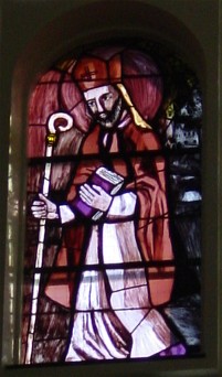
Modestus, called the Apostle of Carinthia or Apostle of Carantania, was most probably an Irish monk and the evangeliser of the Carantanians, an Alpine Slavic people settling in the south of present-day Austria and north-eastern Slovenia, who were among the ancestors of present-day Slovenes.

Claudium Virunum was a Roman city in the province of Noricum, on today's Zollfeld in the Austrian State of Carinthia. Virunum may also have been the name of the older Celtic-Roman settlement on the hilltop of Magdalensberg nearby. Virunum (Virunensis) is today a Catholic titular see.
Boruth, also Borut or Borouth, was the first documented Slavic prince (Knyaz) of Carantania, ruling from about 740 until his death. He was one of the few pagan leaders of the Carantanians to convert to Christianity.

The Stadt auf dem Magdalensberg, is a Noric settlement inhabited from the 1st century BC to the mid 1st century AD, located on the slopes and summit plateau of Magdalensberg on the edge of the Carinthian Zollfeld. It was an important trading hub before and during the initial phase of Roman occupation, particularly for Noric iron. However, with the establishment of the Roman city of Virunum on the Zollfeld, the settlement was ultimately abandoned, with a documented duration spanning approximately 90 years. Notably, one of the most significant discoveries from this site is the Youth of Magdalensberg.