
The Aude is a river of southern France that is 224 kilometres (139 mi) long. Its source is in the Pyrenees mountains then runs to Carcassonne and finally reaches the Mediterranean Sea near Narbonne. The river is navigable by raft or canoe for nearly all of its length. It is registered as essential to the Languedoc-Roussillon region.
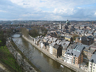
The Sambre is a river in northern France and in Wallonia, Belgium. It is a left-bank tributary of the Meuse, which it joins in the Wallonian capital Namur.

The Jacques-Cartier River is a river in the province of Quebec, Canada. It is 161 km long and its source is Jacques-Cartier Lake in Laurentides Wildlife Reserve, and flows in a predominantly southern direction before ending in the Saint Lawrence River at Donnacona, about 30 km upstream from Quebec City.

The Thérain is a river in France, tributary of the Oise. It is 94.4 km (58.7 mi) long. It rises between Saint-Michel-d'Halescourt and Grumesnil in Seine-Maritime at 175 meters elevation. It flows generally southeast, through Songeons, Milly-sur-Thérain, Beauvais, Hermes and Mouy, and joins the Oise at Creil.

The Montmorency River is a tributary of North-East bank of St. Lawrence river, flowing in the administrative region of Capitale-Nationale, in the province of Quebec, Canada. The course of the river successively crosses the regional county municipality of:

The Croche River is a tributary of Saint-Maurice River, and flows in the regions of Haute-Mauricie and Saguenay-Lac-Saint-Jean, in the province of Quebec, Canada. The Croche River crosses the following cantons of Chabanel and Bécard, in Lac-Ashuapmushuan, in the MRC Le Domaine-du-Roy Regional County Municipality, in the administrative region of Saguenay–Lac-Saint-Jean and the cantons of Michaux, Lavoie, Langelier and Malhiot, in the territory of La Tuque, in Mauricie.
The Ourse, or Ourse de Ferrère, is a French river in the Pyrenees, a tributary of the Garonne. It is 25.4 km (15.8 mi) long. It forms the Barousse valley.

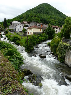
The Volane is a 22.5-kilometre-long (14.0 mi) French river, a tributary of the Ardèche and a sub-affluent of the Rhône.

The Tortue River is a river in the Côte-Nord administrative region, in the province of Quebec, Canada. The course of this river successively crosses the RCM of:

The rivière du Gouffre is a tributary of the left bank of the Saint-Laurent river, flowing into the Capitale-Nationale administrative region, Quebec (Canada). This watercourse flows through Regional County Municipality from:

The Rivière aux Montagnais is a tributary of the southeast bank of the Moncouche River, flowing in the Laurentides Wildlife Reserve, in the unorganized territory of Lac-Jacques-Cartier, in the La Côte-de-Beaupré Regional County Municipality, in the administrative region of Capitale-Nationale, in the province from Quebec, to Canada.
The ruisseau Contourné is a tributary of the north shore of the rivière aux Montagnais, flowing near the northern limit in the Laurentides Wildlife Reserve, in the province from Quebec, to Canada. The course crosses:
The lac au Lard is the main body of water on the slope of the ruisseau du Lac au Lard, located in Haute-Batiscanie, in the town of La Tuque, in the administrative region of Mauricie, in Quebec, in Canada.
The Ruisseau du Lac au Lard stream is a tributary of the west bank of the Jeannotte River, flowing in the western hydrographic slope of the Batiscan River, in the territory of the city of La Tuque, in the administrative region of Mauricie, in Quebec, in Canada. This river crosses the zec de la Bessonne.
The Doucet River is a tributary of the southern shore of Lac au Lard, in the hydrographic slope of the Jeannotte River, in the territory of the town of La Tuque, in the administrative region of Mauricie, in Quebec, in Canada. This river flows in the zec de la Bessonne.
The Rivière des Étangs is a tributary of the rivière du Moulin, descending in the municipality of Saint-Casimir and Deschambault-Grondines, in the Portneuf Regional County Municipality, in the administrative region of Capitale-Nationale, in Quebec, in Canada.
The rivière du Sault is a tributary of the west bank of the ruisseau de la Martine on the northwest bank of the Saint-Laurent river. This river flows in the municipality of Petite-Rivière-Saint-François, in the Charlevoix Regional County Municipality, in the region Capitale-Nationale, in the province of Quebec, in Canada.
The ruisseau du Pied du Mont is a tributary of the southern bank of the upper part of the rivière des Mares, flowing entirely in the town of Baie-Saint-Paul, in the Charlevoix Regional County Municipality, in the administrative region of Capitale-Nationale, in the province of Quebec, in Canada.
The Fortier River is a tributary of the Bécancour River (via William Lake. It flows in the municipalities of Vianney and Saint-Ferdinand, in the L'Érable Regional County Municipality, in the administrative region of Centre-du-Québec, in Quebec, in Canada.

The Haute Perche Canal, despite its title, is a natural river, the Rivière de Haute-Perche, that has been slightly canalised to improve navigation between its mouth in the Bay of Bourgneuf at the port town of Pornic and the upstream settlements of Le Clion-sur-Mer, Chauvé and Arthon-en-Retz. It is located in the Pays de Retz in the Loire-Atlantique department and the Pays de la Loire region. It has also been known as the Canal de Pornic since the 16th century and was sometimes called the Étier de Haute Perche. Historically, it was called the Rouet, after the wheels of the water mills in the port.


