Related Research Articles
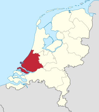
South Holland is a province of the Netherlands with a population of over 3.8 million as of January 2023 and a population density of about 1,410/km2 (3,700/sq mi), making it the country's most populous province and one of the world's most densely populated areas. Situated on the North Sea in the west of the Netherlands, South Holland covers an area of 3,308 km2 (1,277 sq mi), of which 609 km2 (235 sq mi) is water. It borders North Holland to the north, Utrecht and Gelderland to the east, and North Brabant and Zeeland to the south. The provincial capital is the Dutch seat of government The Hague, while its largest city is Rotterdam. The Rhine-Meuse-Scheldt delta drains through South Holland into the North Sea. Europe's busiest seaport, the Port of Rotterdam, is located in South Holland.

IJsselmonde is a river island in the Netherlands, between the Nieuwe Maas, Noord and Oude Maas branches rivers of the Rhine-Meuse delta in the province of South Holland. The city of Rotterdam now occupies most of the northern part of the island and includes the eponymous former village of IJsselmonde, once a separate community. The island was once a rich agricultural region but is mostly suburbs today. Only the mid-south parts of the island have retained their agricultural character.

Someren is a municipality and town in the province of North Brabant in the Southern Netherlands. As of January 2019, the municipality had 19,322 inhabitants, with over half of the population residing in the town. Someren, just south of Helmond and to the north of Weert, Limburg, is located on the provincial border with Limburg.

Krimpen aan den IJssel is a town and municipality in the western Netherlands, in the province of South Holland. The municipality had a population of 29,410 in 2021, and covers an area of 8.95 km2 (3.46 sq mi) of which 1.26 km2 (0.49 sq mi) is water.

Lekkerkerk is a town and former municipality on the Lek River, now part of the municipality of Krimpenerwaard, South Holland province, the Netherlands. Since 1 January 1985 Lekkerkerk is no longer an independent municipality.

Tiengemeten is an island in the Dutch province of South Holland. It is a part of the municipality of Hoeksche Waard and lies about 11 km (7 mi) south of Spijkenisse. Before 1984 the island was administratively split between Goudswaard and Zuid-Beijerland, and until 2019 it was part of the municipality of Korendijk.
Morgenstond is a 'wijk' in the south of The Hague in the Escamp 'stadsdeel'. Morgenstond was built during the early 50s and borders Bouwlust and Vrederust in the west, Leyenburg and Houtwijk in the north, Moerwijk and Zuiderpark in the east and Wateringse Veld in the south. Most streets in Morgenstond are named after places in Drenthe and Overijssel. Morgenstond used to be part of the former Loosduinen municipality, which was annexed by The Hague in 1923.
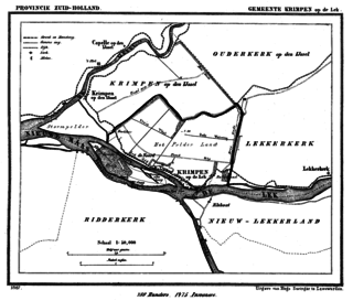
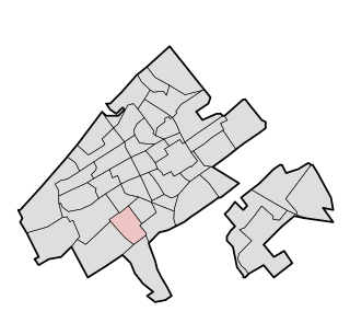
Krimpen aan de Lek is a village on the Lek River in the municipality of Krimpenerwaard, province of South Holland, the Netherlands. It had 6,607 inhabitants in 2008.

Gouderak is a village in the Dutch province of South Holland. It is located 4 km southwest of Gouda on the river Hollandsche IJssel, in the municipality of Krimpenerwaard.

Ouderkerk aan den IJssel is a village in the municipality of Krimpenerwaard, in the province of South Holland, the Netherlands. It is situated along the river Hollandse IJssel and has over 4000 inhabitants.

Rijkswaterstaat, founded in 1798 as the Bureau voor den Waterstaat and formerly translated to Directorate General for Public Works and Water Management, is a Directorate-General of the Ministry of Infrastructure and Water Management of the Netherlands. Its role is the practical execution of the public works and water management, including the construction and maintenance of waterways and roads, and flood protection and prevention. The agency was also involved in the construction of big railway projects such as the Betuweroute and the HSL-Zuid.

Krimpenerwaard is a municipality, a region and a former water board of the Netherlands. It is a rural area located in the east of the province of South Holland, just south of Gouda and east of the Rotterdam conurbation. It is bordered on the north by the river Hollandse IJssel, on the south by the river Lek and on the east by the stream Vlist.
Zuid-Holland Zuid is an official region of the province of South Holland in the Netherlands.
Zuid-Holland West is an official region of the province of South Holland in the Netherlands.

Zuidvleugel is the band of cities and towns located along the southern wing of the Randstad in the Netherlands. It is that part of the Randstad that is located in the Province of South Holland. This developing conurbation extends around 60 kilometres from Dordrecht to Leiden. The two main focal points are the area around Rotterdam and the area around The Hague.

Rijnmond is the conurbation surrounding the city of Rotterdam in the Netherlands. Another term used in this context is Stadsregio Rotterdam. Located on the Rhine–Meuse–Scheldt delta, the region has a combined population of 1,181,289 as of 2021.

The Metropolitan Region Amsterdam is the city region around the city of Amsterdam, the capital of the Netherlands. It lies in the Noordvleugel of the larger polycentric Randstad metropolitan area and encompasses the city of Amsterdam, the provinces of North Holland and Flevoland, as well as 36 further municipalities within the two provinces, with a total population of over 2.5 million inhabitants.
Schielands Hoge Zeedijk, formerly called Hoogendijk is a Dutch dike in the province of South Holland that stretches from the Schie at Schiedam to the Gouwe near Gouda. Constructed in the 13th century, the dike continues to protect an area inhabited by 3 million people from flooding by the North Sea.

Waddinxveen Triangel railway station is a railway station in Waddinxveen, South Holland, Netherlands that opened on 12 February 2018. It is situated on the Gouda–Alphen aan den Rijn railway, which connects Gouda and Alphen aan den Rijn, 1,5 kilometre south of Waddinxveen railway station. Trains running on the line are R-net Stadler FLIRTs.
References
- ↑ Krimpen aan den IJssel also belongs to the Krimpenerwaard region, but is part of Rijnmond.
51°58′19″N4°29′46″E / 51.972°N 4.496°E
| | This South Holland location article is a stub. You can help Wikipedia by expanding it. |