Góra is a village in the administrative district of Gmina Miedźna, within Pszczyna County, Silesian Voivodeship, in southern Poland. It lies approximately 12 kilometres (7 mi) east of Pszczyna and 32 km (20 mi) south of the regional capital Katowice.

Lycée Michel Rodange, abbreviated to LMRL, is a high school in Luxembourg City, in southern Luxembourg. It is located on Campus Geesseknäppchen, along with several other educational institutions, most of which, including Lycée Michel Rodange, is in the quarter of Hollerich, in the south-west of the city.
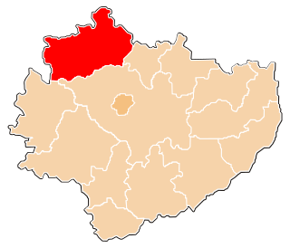
Stare Zasady is a village in the administrative district of Gmina Świedziebnia, within Brodnica County, Kuyavian-Pomeranian Voivodeship, in north-central Poland.
Marianowo is a village in the administrative district of Gmina Brzuze, within Rypin County, Kuyavian-Pomeranian Voivodeship, in north-central Poland.
Mikołajew is a settlement in the administrative district of Gmina Łomża, within Łomża County, Podlaskie Voivodeship, in north-eastern Poland.
Siedlec-Kolonia is a village in the administrative district of Gmina Łęczyca, within Łęczyca County, Łódź Voivodeship, in central Poland.

Teklin is a village in the administrative district of Gmina Żelechlinek, within Tomaszów Mazowiecki County, Łódź Voivodeship, in central Poland. It lies approximately 6 kilometres (4 mi) east of Żelechlinek, 24 km (15 mi) north of Tomaszów Mazowiecki, and 45 km (28 mi) east of the regional capital Łódź.
Godów is a village in the administrative district of Gmina Chodel, within Opole Lubelskie County, Lublin Voivodeship, in eastern Poland. It lies approximately 3 kilometres (2 mi) south-west of Chodel, 12 km (7 mi) south-east of Opole Lubelskie, and 37 km (23 mi) south-west of the regional capital Lublin.
Gardzienice Drugie is a village in the administrative district of Gmina Piaski, within Świdnik County, Lublin Voivodeship, in eastern Poland. It lies approximately 3 kilometres (2 mi) south of Piaski, 17 km (11 mi) south-east of Świdnik, and 26 km (16 mi) south-east of the regional capital Lublin.
Kąty Drugie is a village in the administrative district of Gmina Szczebrzeszyn, within Zamość County, Lublin Voivodeship, in eastern Poland.
Niedomice is a village in the administrative district of Gmina Żabno, within Tarnów County, Lesser Poland Voivodeship, in southern Poland. It lies approximately 3 kilometres (2 mi) south of Żabno, 12 km (7 mi) north-west of Tarnów, and 69 km (43 mi) east of the regional capital Kraków.

Janczewice is a village in the administrative district of Gmina Lesznowola, within Piaseczno County, Masovian Voivodeship, in east-central Poland. It lies approximately 3 kilometres (2 mi) north of Lesznowola, 8 km (5 mi) north-west of Piaseczno, and 13 km (8 mi) south of Warsaw.
Torzeniec PGR is a settlement in the administrative district of Gmina Doruchów, within Ostrzeszów County, Greater Poland Voivodeship, in west-central Poland. It lies approximately 6 kilometres (4 mi) south of Doruchów, 9 km (6 mi) south-east of Ostrzeszów, and 141 km (88 mi) south-east of the regional capital Poznań.
Kolonia Lisewo is a settlement in the administrative district of Gmina Pyzdry, within Września County, Greater Poland Voivodeship, in west-central Poland.
Hamerbark is a village in the administrative district of Gmina Stara Kiszewa, within Kościerzyna County, Pomeranian Voivodeship, in northern Poland. It lies approximately 8 kilometres (5 mi) north-west of Stara Kiszewa, 11 km (7 mi) south-east of Kościerzyna, and 49 km (30 mi) south-west of the regional capital Gdańsk.
Janów is a village in the administrative district of Gmina Elbląg, within Elbląg County, Warmian-Masurian Voivodeship, in northern Poland. It lies approximately 6 kilometres (4 mi) east of Elbląg and 76 km (47 mi) north-west of the regional capital Olsztyn.
Łaniewo-Leśniczówka is a village in the administrative district of Gmina Lidzbark Warmiński, within Lidzbark County, Warmian-Masurian Voivodeship, in northern Poland.
Jabłonka is a settlement in the administrative district of Gmina Ostróda, within Ostróda County, Warmian-Masurian Voivodeship, in northern Poland.
Jelonki is a settlement in the administrative district of Gmina Połczyn-Zdrój, within Świdwin County, West Pomeranian Voivodeship, in north-western Poland. It lies approximately 5 kilometres (3 mi) south of Połczyn-Zdrój, 24 km (15 mi) east of Świdwin, and 107 km (66 mi) east of the regional capital Szczecin.

Ye Olde Cock Tavern is a Grade II listed public house at 22 Fleet Street, London EC4. It is part of the Taylor Walker Pubs group.