Åsbygda

Last updated
Asbygda Asbygda, Ringerike.jpg
Åsbygda
Salemkirken Salemkirken i Asbygda, Ringerike.jpg
Salemkirken
Asbygda school Asbygda skole, Ringerike.jpg
Åsbygda school

Åsbygda is a small village in Ringerike municipality of Buskerud, Norway.

Ringerike (municipality) Municipality in Buskerud, Norway

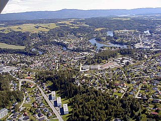
Ringerike is a municipality in Buskerud county, Norway. It is part of the traditional region of Ringerike. The administrative centre of the municipality is the town of Hønefoss.

Buskerud County (fylke) of Norway

Buskerud is a county in Norway, bordering Akershus, Oslo, Oppland, Sogn og Fjordane, Hordaland, Telemark and Vestfold. The county extends from the Oslofjord and Drammensfjorden in the southeast to Hardangervidda mountain range in the northwest. The county administration is located in Drammen. Together with Akershus and Østfold, Buskerud will form the new, larger county Viken, from 1 January 2020.

Norway constitutional monarchy in Northern Europe

Norway, officially the Kingdom of Norway, is a Nordic country in Northwestern Europe whose territory comprises the western and northernmost portion of the Scandinavian Peninsula; the remote island of Jan Mayen and the archipelago of Svalbard are also part of the Kingdom of Norway. The Antarctic Peter I Island and the sub-Antarctic Bouvet Island are dependent territories and thus not considered part of the kingdom. Norway also lays claim to a section of Antarctica known as Queen Maud Land.

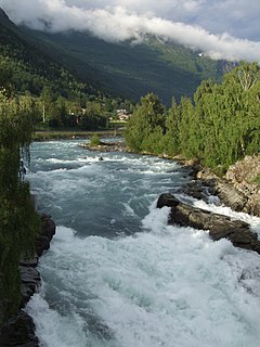
Åsbygda can be said to include the areas along the Randselva river, down towards the village of Viul and north to the county border at Jevnaker on the Randsfjorden in Oppland. This area experienced hard treatment during World War II, with several fierce battles conducted here. Åsbygda school was shut down at the end in June 2007. [1] [2]

Jevnaker Municipality in Oppland, Norway

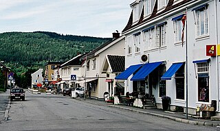
Jevnaker is a municipality in Oppland county, Norway. The administrative centre of the municipality is the village of Jevnaker with a population of 4,302.

Randsfjorden lake

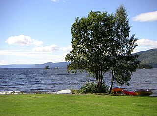
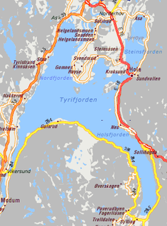
Randsfjorden is Norway's fourth-largest lake with an area of 138 km2 (53 sq mi). Its volume is estimated at just over 7 km3 (1.7 cu mi), and its greatest depth is 120 metres (390 ft). The lake is 135 metres (443 ft) above sea level. It is located in the county of Oppland and borders the municipalities of Gran, Jevnaker, Nordre Land, and Søndre Land in the districts of Land and Hadeland. It is drained by the Randselva river.

Oppland County (fylke) of Norway

Oppland[²ɔplɑn](listen) is a county in Norway, bordering Trøndelag, Møre og Romsdal, Sogn og Fjordane, Buskerud, Akershus, Oslo and Hedmark. The county administration is in Lillehammer. Oppland is, together with Hedmark, one of the only two landlocked counties of Norway.

Related Research Articles

Hønefoss Unincorporated city in Buskerud, Norway

Hønefoss is a town and the administrative center of the municipality of Ringerike in Buskerud county, Norway. Hønefoss is an industrial center of inner Østlandet, containing several factories and other industry. As of 1 January 2008, Hønefoss has 14,177 inhabitants. In 1852, Hønefoss received town status and was separated from Norderhov. In 1964, Hønefoss ceased being a separate municipality and became part of Ringerike.

Bergermoen is an industrial area on the border between the municipals Ringerike in Buskerud and Jevnaker in Oppland. The Norwegian kitchen manufacturer Norema has its main office here.

Begna (river) river in Norway

The Begna is a river in Buskerud and Oppland counties in Norway. It is formed by the merging of the rivers Otrøelva and Ylja above Lake Vangsmjøsa. It is also the name of the village of Begna located by the river. The Norwegian writer, Mikkjel Fønhus lived much of his life and located most of his novels along the Begna in Oppland.

Prestfoss

Prestfoss is the administrative center of Sigdal municipality in Buskerud, Norway.

Holmsbu

Holmsbu is a small village located in Buskerud, Norway.

Bøverdal valley

Bøverdal is a valley in Lom municipality in the county of Oppland, Norway. The Bøvra river flows through the valley. For many centuries a route went from Lom village up through Bøverdal and down into Sogn.

Steinsåsen

Steinsåsen is a village in Hole municipality in Buskerud, Norway. Steinsåsen located on the west side of Steinsfjorden, the eastern arm of Tyrifjorden. The village is about 9 km southeast of Honefoss. European route E16 passes through Steinsåsen as it travels from Oslo to Bergen.

Karljohansvern

Karjohansvern at Horten was the main base for the Royal Norwegian Navy from 1819 to 1963.

Hen, Buskerud

Hen is a small village in the municipality of Ringerike in Buskerud, Norway.

Haugsbygd

.

Geithus

Geithus is a village in Modum municipality of Buskerud, Norway. It is situated between the villages of Åmot and Vikersund.

Kistefos Wood Pulp Mill

The Kistefos Wood Pulp Mill is a former pulp mill and hydroelectric power plant in Jevnaker, Norway. It was founded by Kistefos at the river Randselva in 1889.

Gulsvik

Gulsvik is a village in the municipality of Flå in Buskerud, Norway. It is located in Hallingdal at the north end of Lake Krøderen.

Fanahammeren

Fanahammeren or Fanahammaren is a residential village area at the eastern end of the Fanafjorden in the city of Bergen in Hordaland county, Norway. Fanahammeren lies about 15 kilometres (9.3 mi) south of the city centre.

Gjelleråsen Village in Østlandet, Norway

Gjelleråsen is an area which constitutes part of Oslomarka outside Oslo, Norway.

Ask is a village in Ringerike municipality, Buskerud, Norway. Ash is located along Norwegian national road Rv35 approx. 6 km southwest of the municipality Hønefoss. The village once had a railway station on the Randsfjord Line. Ask is most known for Ask Chapel and for Ask gods, a Manor house owned by the Løvenskiold family.

Nathorst Land land area between Van Keulenfjorden and Van Mijenfjorden on Spitsbergen, Svalbard

Nathorst Land is the land area between Van Keulenfjorden and Van Mijenfjorden on Spitsbergen, Svalbard.

Elingård

Elingård is a manor house and an estate located at Fredrikstad in Østfold, Norway. The manor is situated on the Onsøy peninsula outside of Fredrikstad. Elingaard manor is currently operated as a museum.

Hval (Ringerike)

Hval is a village in Ringerike in Buskerud, Norway. The area lies north of Haugsbygd and east of Hønefoss. The old road Hvalsveien runs from Haugsbygd to Hval station, where it changes into Viulsveien in a junction between Hvalsmoveien (E16) and Viul.

References

  1. Rune Nedrud. "Randselva". Store norske leksikon. Retrieved September 15, 2016.
  2. Geir Thorsnæs. "Viul". Store norske leksikon. Retrieved September 15, 2016.

Coordinates: 60°12′15″N10°22′23″E / 60.20417°N 10.37306°E / 60.20417; 10.37306

Geographic coordinate system Coordinate system

A geographic coordinate system is a coordinate system that enables every location on Earth to be specified by a set of numbers, letters or symbols. The coordinates are often chosen such that one of the numbers represents a vertical position and two or three of the numbers represent a horizontal position; alternatively, a geographic position may be expressed in a combined three-dimensional Cartesian vector. A common choice of coordinates is latitude, longitude and elevation. To specify a location on a plane requires a map projection.