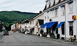
Jevnaker Municipality Jevnaker kommune | |
---|---|
Coordinates: 60°16′16″N10°24′7″E / 60.27111°N 10.40194°E | |
Country | Norway |
County | Akershus |
District | Hadeland |
Administrative centre | Jevnaker |
Government | |
• Mayor (2003) | Hilde Brørby Fivelsdal (Ap) |
Area | |
• Total | 224 km2 (86 sq mi) |
• Land | 195 km2 (75 sq mi) |
• Rank | #317 in Norway |
Population (2006) | |
• Total | 6,312 |
• Rank | #159 in Norway |
• Density | 33/km2 (90/sq mi) |
• Change (10 years) | +8% |
Demonym | Jevnakersokning [1] |
Official language | |
• Norwegian form | Bokmål |
Time zone | UTC+01:00 (CET) |
• Summer (DST) | UTC+02:00 (CEST) |
ISO 3166 code | NO-3236 [3] |
Website | Official website |
Jevnaker is a municipality in Akershus county, Norway. The administrative centre of the municipality is the village of Jevnaker with a population of 4,302.
The parish of Jævnaker was established as a municipality on 1 January 1838 (see formannskapsdistrikt). The area of Lunner was separated from the municipality of Jevnaker on 1 January 1898 to form a municipality of its own. From 2020 to 2023 the municipality belonged to Viken county, it was Oppland before that.
The municipality is (together with Gran and Lunner) a part of the Hadeland traditional region. The Hadeland region has a population of about 30,000. The region spreads over a large area including several villages and towns.
The municipality (originally the parish) is named after the old Jevnaker farm (Old Norse: Jafnakr), since the first church was built here. The first element is jafn which means "even" or "flat" and the last element is akr which means "field" or "acre". Prior to 1889, the name was written "Jævnaker". [4]
The coat-of-arms is from modern times, granted in 1983. The arms show three silver-colored glasses, since glassblowing has been a long tradition and industry in the municipality (see Hadeland Glassverk). The red colour of the background was also chosen as the colour of the glass when hot. [5] [6]
Jevnaker is situated at the southern end of the Randsfjorden. The municipality is bordered to the north by the municipality of Gran, to the east by Lunner, and to the southwest by Ringerike (in Buskerud county).
Jevnaker municipality has an area of 224 square kilometres (86 sq mi), measuring 25.5 kilometres (15.8 mi) on a north–south axis and 21 kilometres (13.0 mi) on an east–west axis. The municipality lies in the extreme south of Oppland county.
The highest point is Svarttjernshøgda with a height of 717 metres (2,352 ft).
Jevnaker is home to Hadeland Glassverk, an old glassblowing factory with over 600,000 visitors each year, ranking it as the third most popular tourist destination in Norway.
The Kistefos Træsliberi, an industrial museum with a very impressive Art collection, is also located in Jevnaker
In 2015, 96 inhabitants had Polish parents and/or were Polish (themselves); 66 had Lithuanian parents and/or were Lithuanian. [7]
Ancestry | Number |
---|---|
Poland | 96 |
Lithuania | 66 |
Germany | 41 [8] |
Russia | 35 |
Denmark | 32 |
Bosnia-Herzegovina | 30 |
Sweden | 27 |
Akershus is a county in Norway, with Oslo as its administrative centre, though Oslo is not located within Akershus. Akershus has been a region in Eastern Norway with Oslo as its main city since the Middle Ages, and is named after the Akershus Fortress in Oslo and ultimately after the medieval farm Aker in Oslo. From the Middle Ages to 1919, Akershus was a main fief and main county that included most of Eastern Norway, and from the 17th century until 2020 and again from 2024, Akershus also has a more narrow meaning as a smaller central county in the Greater Oslo Region. Akershus is Norway's largest county by population with over 716,000 inhabitants.
Oppland is a former county in Norway which existed from 1781 until its dissolution on 1 January 2020. The old Oppland county bordered the counties of Trøndelag, Møre og Romsdal, Sogn og Fjordane, Buskerud, Akershus, Oslo and Hedmark. The county administration was located in the town of Lillehammer.
Aurskog-Høland is a municipality in Akershus county, Norway. It is part of the Romerike traditional region. The administrative centre of the municipality is the village of Bjørkelangen. The municipality of Rømskog, in Østfold county was merged into Aurskog-Høland on 1 January 2020.
Fet was a municipality in Akershus county, Norway. It was part of the Romerike traditional region. The administrative centre of the municipality is the village of Fetsund.
Rælingen is a village and municipality in Akershus county, Norway. It is part of the traditional region of Romerike. The administrative centre of the municipality is the village of Fjerdingby. Rælingen was separated from the municipality of Fet on 1 July 1929.
Enebakk is a municipality in Akershus county, Norway. It is part of the Follo traditional region. The administrative centre of the municipality is the village of Kirkebygda. The parish of Enebak was established as a municipality on 1 January 1838. The part of Enebakk lying east of lake Øyeren was transferred to Fet municipality in 1962.
Nannestad is a municipality in Akershus county, Norway. It is part of the traditional region of Romerike. The administrative centre of the municipality is the village of Teigebyen.
Hurdal is a municipality in Akershus county, Norway. It is part of the traditional region of Romerike. The administrative centre of the municipality is the village of Hurdal.
is a municipality in Innlandet county, Norway. It is located in the traditional district of Gudbrandsdal. The administrative centre of the municipality is the village of Vålebru.
Vestre Toten is a municipality in Innlandet county, Norway. It is located in the traditional district of Toten. The administrative centre of the municipality is the village of Raufoss. Other villages in the municipality include Bøverbru, Eina, and Reinsvoll.
Lunner is a municipality in Akershus county, Norway. It is part of the traditional region of Hadeland. The administrative centre of the municipality is the village of Roa. Lunner was established when it was separated from the municipality of Jevnaker on 1 January 1898. From 1 January 2020 the municipality belongs to Viken county, it was Oppland before that.
is a municipality in Innlandet county, Norway. It is located in the traditional district of Hadeland. The administrative centre of the municipality is the village of Jaren. Other villages in Gran include Bjoneroa, Brandbu, Egge, Gran, and Ringstad.
Søndre Land is a municipality in Innlandet county, Norway. It is located in the traditional district of Land. The administrative centre of the municipality is the village of Hov. Other villages in the municipality include Fluberg and Odnes.
Nordre Land is a municipality in Innlandet county, Norway. It is located in the traditional district of Land. The administrative centre of the municipality is the village of Dokka. Other villages in the municipality include Vest-Torpa, Nord-Torpa, Aust-Torpa, Fagerlund, and Nordsinni.
Vang is a municipality in Innlandet county, Norway. It is located in the traditional district of Valdres. The administrative centre of the municipality is the village of Vang i Valdres. Other villages in Vang include Hænsgardane, Nystuen, Øye, Ryfoss, and Tyinkrysset.
Hadeland is a traditional district in the southeastern part of Norway. It is centered on the southern part of the large lake Randsfjorden in Innlandet and Akershus counties. The district consists of the municipalities Gran in Innlandet county and Jevnaker and Lunner in Akershus county. Hadeland occupies the area north of the hills of Nordmarka close to the Norwegian capital Oslo. The soil around the Randsfjorden is amongst the most fertile in Norway. Hadeland accounts for just 5% of the country's area, but it represents 13% of its agricultural land. Farmers harvest grains and potatoes. Pigs, dairy cattle, and horses are also bred at farms there.
Gjøvik District Court was a district court in Innlandet county, Norway. The court was based in Gjøvik. The court existed from 2009 until 2021. It served the municipalities of Gjøvik, Lunner, Gran, Søndre Land, Nordre Land, Østre Toten, and Vestre Toten. Cases from this court could be appealed to Eidsivating Court of Appeal.
Innlandet is a county in Norway. It was created on 1 January 2020 with the merger of the old counties of Oppland and Hedmark. The new county has an area of 52,113 square kilometres (20,121 sq mi), making it the largest county in Norway after Troms og Finnmark was split up in 2024.
Brandbu is a former municipality in the old Oppland county, Norway. The 471-square-kilometre (182 sq mi) municipality existed from 1897 until its dissolution in 1962. The area is now part of Gran Municipality in the traditional district of Hadeland. The administrative centre was the village of Brandbu. The municipality included land on both sides of the large lake Randsfjorden, although most of the municipal residents lived on the east side of the lake.