The parish of Nitedal was established as a municipality on 1 January 1838 (see formannskapsdistrikt).
Name
The name (Old Norse: Nitjudalr) is an old district name. The first element is the genitive case of the river name Nitja (now Nitelva) and the last element is dalr which means "valley" or "dale". The meaning of the river name is unknown. Prior to 1918, the name was written "Nittedalen".
Coat-of-arms
The coat-of-arms is from modern times. They were granted on 23 January 1987. The arms show the two silver lines running in a bend sinister direction on a green background. They represent the main transportation lines that run through the municipality from Oslo to other parts of the country: the main highway and the railroad, they also can represent skiing tracks, an old winter transportation method. At the same time the two lines symbolize matches, as one of Norway's oldest match factories was founded in Nittedal. The lines also symbolize tree logs, as forestry is of great importance for the local economy.[4][5]
Geography
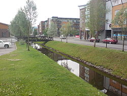
Nittedal town hall.
Nittedal lies directly northeast of Oslo and serves as a suburb to the capital. It is located on both sides of the Nitelva river. The southernmost population centre is Hagan. Further north lie the centres of Slattum, Rotnes, Åneby, Grønvoll, Varingskollen, and Hakadal.
History
In 1902 the construction of the Gjøvik Line reached the west side of Nittedal, from Oslo and through the forest.[6]
Demography
Number of minorities (1st and 2nd generation) in Nittedal by country of origin in 2017[7]
↑https://snl.no/Nittedal "Etter at Gjøvikbanen i 1902 var ført fra Oslo over skogen til vestsiden av Nittedal, vokste det her opp villabebyggelser, særlig ved Nittedal stasjon."
This page is based on this Wikipedia article Text is available under the CC BY-SA 4.0 license; additional terms may apply. Images, videos and audio are available under their respective licenses.