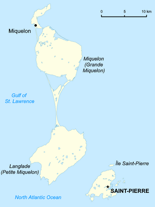
Saint Pierre and Miquelon is a French overseas collectivity in the Western Hemisphere and the Northern Hemisphere. It consists of an island archipelago, off the coast of Newfoundland, near North America. The collectivity shares a maritime boundary with Canada.

Brest is a port city in the Finistère department, Brittany. Located in a sheltered bay not far from the western tip of a peninsula and the western extremity of metropolitan France, Brest is an important harbour and the second largest French military port after Toulon. The city is located on the western edge of continental France. With 139,456 inhabitants (2020), Brest forms Western Brittany's largest metropolitan area, ranking third behind only Nantes and Rennes in the whole of historic Brittany, and the 25th most populous city in France (2019); moreover, Brest provides services to the one million inhabitants of Western Brittany. Although Brest is by far the largest city in Finistère, the préfecture of the department is in the much smaller town of Quimper.
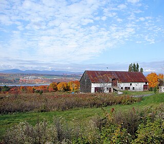
Île d'Orléans is an island located in the Saint Lawrence River about 5 kilometres (3.1 mi) east of downtown Quebec City, Quebec, Canada. It was one of the first parts of the province to be colonized by the French, and a large percentage of French Canadians can trace ancestry to early residents of the island. The island has been described as the "microcosm of traditional Quebec and as the birthplace of francophones in North America."

Somme is a department of France, located in the north of the country and named after the Somme river. It is part of the Hauts-de-France region. It is bordered by Pas-de-Calais and Nord to the north, Aisne to the east, Oise to the south and Seine-Maritime to the southwest. To the northwest, its coastline faces the English Channel and it shares maritime borders with Kent and East Sussex in the United Kingdom. It had a population of 570,559 in 2019.

The Minas Basin is an inlet of the Bay of Fundy and a sub-basin of the Fundy Basin located in Nova Scotia, Canada. It is known for its extremely high tides.
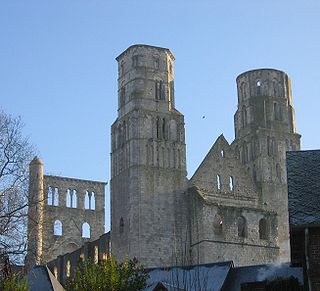
Jumièges is a commune in the Seine-Maritime department in the Normandy region in north-western France.

The Plougastel Bridge, or Albert-Louppe Bridge, is a bridge over the river Élorn near Brest, France, connecting Plougastel-Daoulas and Le Relecq-Kerhuon.
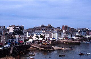
Douarnenez, is a commune in the French department of Finistère, region of Brittany, northwestern France.
The Route nationale 12, or RN12, is a trunk road (nationale) in France connecting Paris with Brittany. The road forms part of European route E50. It is approximately 570 km (350 mi) long.

Landerneau is a commune in the Finistère department of Brittany in north-western France.

Iroise or the Iroise Sea is the part of the Atlantic Ocean which stretches from the Ile de Sein to Ushant off the coast of Brittany in north-western France. It is contained within the Celtic Sea, bordering the remainder of the Celtic Sea to the north and west, and the Bay of Biscay to the south. It is one of the most dangerous seas in Europe for sea-going vessels. In winter, there are often violent storms with huge waves. It is also one of the richest areas for marine life and was designated as one of UNESCO's biosphere reserves in 1988 and as France's first marine park in October 2007.
Landévennec is a commune in the Finistère department of Brittany in north-western France.

Veules-les-Roses is a commune in the Seine-Maritime department in the Normandy region in northern France.

The roadstead of Brest is a roadstead or bay located in the Finistère department in Brittany in northwestern France. The surface area is about 180 km². The port of Brest and one of the two French naval bases, Brest Arsenal, are located on its northern edge. It is linked to the Atlantic Ocean by the Goulet de Brest, a strait about 1.8 km wide. Three main rivers drain into the roadstead: the Penfeld, the Élorn and the Aulne.

The Vedettes côtières de surveillance maritime are swift craft of the French Gendarmerie maritime. 24 boats of the type have been commissioned. They are based in various harbours of France, and are used for coast guard duties ranging from rescue to military tasks, including monitoring of pollution, sea police, and interception of illegal immigrants and drug traffickers.
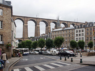
The railway from Paris to Brest is a 622-kilometre long railway line in France that connects Paris and the western port city Brest, via Le Mans and Rennes. It is used for passenger and freight traffic.

The Pont de l'Iroise is a cable-stayed bridge in Finistère, Brittany, France, which spans the Élorn river where it enters the roadstead of Brest. It carries route nationale 165, the road between Brest and Quimper, and connects Le Relecq-Kerhuon to the north with Plougastel-Daoulas to the south. The bridge is named after the Iroise Sea, into which the roadstead of Brest opens.
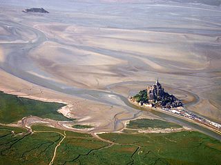
The Mont-Saint-Michel Bay is located between Brittany and the Normandy peninsula of Cotentin. The bay was listed as a UNESCO world heritage site in 1979 for its aesthetic quality and its importance to the Christian tradition. Due to the significant tidal movements in this region a large part of the bay is uncovered at low tide. There are two granitic islands in the bay: Tombelaine and the Mont-Saint-Michel. Many birds and harbor seals live in this area.

St. Lawrence Estuary stretches from west to east for 655 km, from the outlet of Lake Saint Pierre to Pointe-des-Monts, where it becomes the Gulf of St. Lawrence, in Quebec, Canada.
The Kegaska River is a salmon river flowing on North shore of Estuary of Saint Lawrence. It crosses the unorganized territory of Petit-Mécatina, in the Le Golfe-du-Saint-Laurent Regional County Municipality, in the administrative region in the Côte-Nord, in the province of Quebec, Canada.

