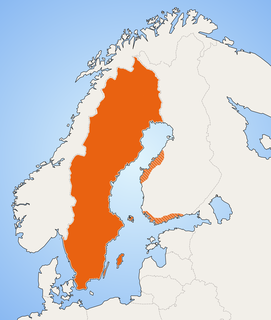
Borgholm Municipality is a municipality in Kalmar County, south-eastern Sweden, constituting the northern half of the island of Öland in the Baltic Sea. The municipal seat is located in the city of Borgholm.

Mörbylånga Municipality is a municipality in Kalmar County, in south-eastern Sweden, located on the island of Öland in the Baltic Sea. The seat is located in the town of Mörbylånga, while the largest town is Färjestaden.

Öland County, or Ölands län, was a county of Sweden, between 1819 and 1826. It consisted of the island of Öland, designating the historical province of Öland as its own county. A Governor resided briefly at Borgholm, but the island is today part of the Kalmar County.

Eketorp is an Iron Age fort in southeastern Öland, Sweden, which was extensively reconstructed and enlarged in the Middle Ages. Throughout the ages the fortification has served a variety of somewhat differing uses: from defensive ringfort, to medieval safe haven and thence a cavalry garrison. In the 20th century it was further reconstructed to become a heavily visited tourist site and a location for re-enactment of medieval battles. Eketorp is the only one of the 19 known prehistoric fortifications on Öland that has been completely excavated, yielding a total of over 24,000 individual artifacts. The entirety of southern Öland has been designated as a World Heritage Site by UNESCO. The Eketorp fortification is often referred to as Eketorp Castle.

Halltorp is one of the earliest manor houses on the island of Öland, Sweden, dating from the 11th century AD. In early documents it is known as Hauldtorp, and it is cited as one of the early Viking settlements of Öland. In earlier times it has functioned as a royal farm associated with the Swedish Crown and was considered one of the finest hunting preserves on the island. There is a relict oak forest on the present grounds which contains numerous trees that are centuries old. Halltorp is in an area rich in history and biodiversity, and most of the island of Öland has been designated as a World Heritage Site. The site is adjacent to the perimeter highway, Route 136.

Stora Alvaret is an alvar, a barren limestone terrace, in the southern half of the island of Öland, Sweden. Stora Alvaret is a dagger shaped expanse almost 40 kilometres (25 mi) long and about 10 kilometres (6.2 mi) at the widest north end. The area of this formation exceeds 260 square kilometres (100 sq mi), making it the largest such expanse in Europe and comprising over one fourth of the land area of the island.

Alby is a village on the Baltic Sea in the Hulterstad district at the western fringe of the Stora Alvaret on the island of Öland, Sweden.
Ottenby is a town on the island of Öland, Sweden, located in Ås parish, Mörbylånga Municipality in Kalmar County. Ottenby is located just north of the southern tip of Öland, over three miles south of the area's main town, Mörbylånga. Ottenby is also the name of the mansion and a royal demesne, now a nature reserve.

Gettlinge is a village in the southwest portion of the island of Öland, Sweden. It is known for its impressive Viking stone ship burial ground. Gettlinge is situated on the western fringe of the Stora Alvaret, a World Heritage Site designated by UNESCO. The site is readily visible from the perimeter highway, Route 136. Gettlinge, as most prehistoric burial sites on Öland, is established on the low-lying ridge, described by Hogan as a geological formation of thickened soil in this alvar region of otherwise extremely thin soil mantle. This ridge was one of the few places on the southern part of the island that had sufficient soil depth for creation of burial mounds.
Hulterstad is a small coastal town on the southeastern part of the island of Öland, Sweden. Hulterstad is situated at the eastern fringe of the Stora Alvaret, a limestone pavement habitat which hosts a diversity of rare plants and has been designated a World Heritage Site by UNESCO. Hulterstad is the municipal government center for this district and central records for centuries were kept at the Hulterstad Church. Significant gravefields and a Viking stone burial ship structure are located immediately south of Hulterstad. To the north is located the village of Alby, where a mesolithic village of early human settlement has been found, and to the south is the Ottenby Nature Reserve. Across the alvar to the west is the village of Gettlinge.
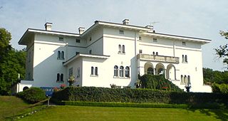
Solliden Palace, commonly known as just Solliden, is the summer residence of the Swedish Royal Family and the personal private property of King Carl XVI Gustaf. The palace is situated near the Borgholm Castle ruin on the island of Öland in southern Sweden along its Baltic coast.

Irumbuliyur Junction is one of the important junctions in the city of Chennai, India. It is located at Irumbuliyur near Tambaram in Chennai at the intersection of NH 45 with the Chennai Bypass.

Saint Birgitta's chapel is located on the east coast of the island of Öland, Sweden, some four kilometers from the village of Bredsättra in Bredsättra socken, Borgholm Municipality, in a marshy area called Kapelludden. The chapel dates from the 13th century; today nothing remains but the foundation and the eastern wall, the western wall having fallen down during a storm in 1914.
Bredsättra socken is a former socken of Runsten Hundred on Öland, Sweden. Since 1974, it's part of the Borgholm Municipality on the island of Öland, Sweden. It covers 29.11 square kilometers and had 251 inhabitants in 2000.

Öland runic inscription 18, or Öl 18 in the Rundata designation, is a runestone in Seby, in Segerstads socken on Öland, Sweden.

Borgholm Church is a church in Borgholm on Swedish Baltic Sea island of Öland. Belonging to Borgholm Parish of the Church of Sweden, it was opened on Pentecost Sunday in 1879.
Astad is a village with less than 50 inhabitants (2005) on the island of Öland, Kalmar County, Sweden. It belongs to the municipality Borgholm.
Störlinge is a village on the island of Öland in the municipality of Borgholm, Kalmar County, Sweden. The village has 58 inhabitants (2005).