Ørsta (help·info) is a municipality in Møre og Romsdal county, Norway. It is part of the Sunnmøre region of Western Norway. The administrative centre of the municipality is the village of Ørsta. Other villages in the municipality include Hovdebygda, Flåskjer, Leira, Liadal, Urke, Bjørke, Barstadvik, Åmdalen, Follestaddalen, Nordre Vartdal, Vartdal, Sæbø, Sætre, Store-Standal, and Ytre Standal.
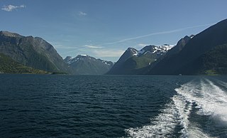
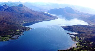
Hjørundfjorden is a fjord in the traditional district of Sunnmøre in Møre og Romsdal county, Norway. It is located mostly within Ørsta Municipality, although part of the mouth of the fjord is in Sykkylven Municipality. The 35-kilometre (22 mi) long fjord is an arm off of the larger Storfjorden that stretches south from Ålesund Municipality. Villages along the shores of the fjord include Bjørke, Leira, Viddal, Sæbø, and Store Standal.

Herefossfjorden is a lake in the municipality of Birkenes in Aust-Agder county, Norway. The 3.7-square-kilometre (1.4 sq mi) lake is about 9 kilometres (5.6 mi) long and it is part of the Tovdalselva river. The Gauslåfjorden and Uldalsåna lakes flow into Herefossfjorden near the village of Herefoss at the northern end of the lake. The Uldalsåna lake is held back by a dam and the Gauslåfjorden flows over a waterfall into the Herefossfjorden. The Norwegian National Road 41 runs along the eastern shore. The village of Herefoss lies on the northern edge of the lake and the village of Søre Herefoss lies at the southern end of the fjord. The old municipality of Herefoss existed from 1838 until 1967 and it included all the land surrounding the lake.

Jølstravatnet or Jølstravatn is a lake in the municipality of Jølster in Sogn og Fjordane county, Norway. The lake empties its water into the 20-kilometre (12 mi) long Jølstra river which then flows into the Førdefjorden. The impressive eastern arm of Jølstravatn is called Kjøsnesfjorden, although it is not a true fjord that is part of the sea. The villages of Skei, Helgheim, Ålhus, and Vassenden are located on the shores of the lake.

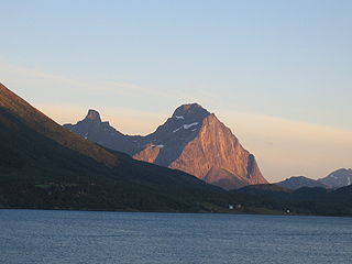
Skårasalen is a mountain in the municipality of Ørsta in Møre og Romsdal county, Norway. The 1,542-metre (5,059 ft) tall mountain has the seventh largest prominence of all mountains in Norway. The mountain is located about 5 kilometres (3 mi) south of the village of Sæbø and the Bondalen valley in the Hjørundfjord area of Ørsta. The nearby mountain, Jakta, lies directly to the east on the opposite side of the fjord.
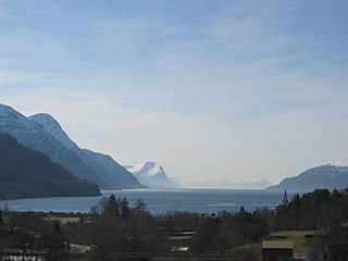
Storfjorden or Storfjord is a 110-kilometre (68 mi) long fjord in the Sunnmøre region of Møre og Romsdal county, Norway. It stretches from the village of Hareid in the west to the villages of Tafjord and Geiranger in the east. The Storfjorden system branches off into several smaller fjords including the famous Geirangerfjord and Tafjorden. At the village of Stranda, the main fjord branches off into the Sunnylvsfjorden-Geirangerfjorden to the west and the Norddalsfjorden-Tafjorden to the east.

Norddalsfjorden is a branch off of the main Storfjorden in Møre og Romsdal county, Norway. The fjord is located in Norddal Municipality and a small part is also in Stranda Municipality. The fjord is 16 kilometres (9.9 mi) long, when you include the Tafjorden arm that stretches further east, it is 24 kilometres (15 mi) in total. In the Middle Ages, the combined Norddalsfjorden and Tafjorden were probably called «Todarfjorden» (Tafjorden). Norwegian County Road 63 and Norwegian County Road 650 runs along the fjord and includes a ferry crossing between Eidsdal and Linge. In the 1960s villages Stranda-Liabygda-Eidsdal-Valldal-Norddal-Fjørå-Tafjord were still connected by a web of ferry crossings.
Tjongsfjorden is a fjord in the municipality of Rødøy in Nordland county, Norway. The 17-kilometre (11 mi) long fjord begins just west of the Svartisen glacier and flows west and flows into the Rødøyfjorden, just east of the island of Rødøya. The mountain Blokktinden lies on the southern shore of the fjord. The villages of Tjong and Vågaholmen lie along the northern shore of the fjord. Norwegian County Road 17 runs along the inner part of the fjord.

Skipsfjorden is the southern arm of the Kamøyfjorden, a fjord on the eastern side of the island of Magerøya in Nordkapp Municipality in Finnmark county, Norway.
Balsfjorden (Norwegian) or Báhccavuotna (Northern Sami) is a fjord in Troms county, Norway. The 57-kilometre (35 mi) long fjord runs through the municipalities of Balsfjord and Tromsø. It branches off the Tromsøysundet strait just south of the city of Tromsø and it flows in a north-south direction, ranging from 2 to 7 kilometres wide. The European route E8 highway follows most of the eastern shore of the fjord and the European route E6 highway runs along the southern end of the fjord. The village of Storsteinnes lies along the southwestern coast of the fjord and the village of Nordkjosbotn lies at the southeastern end of the fjord.
Jøsenfjorden is a fjord in the municipality of Hjelmeland in Rogaland county, Norway. The fjord is a branch off of the main Boknafjorden. The fjord has a length of 24 kilometres (15 mi) and a width between 1 to 2 kilometres. The Norwegian National Road 13 runs along the northern shore of the fjord.

Lyngen is a fjord in Troms county, Norway. The 82-kilometre (51 mi) long fjord is the longest fjord in Troms county and it is often used as the dividing line between "northern Troms" and "southern Troms". The fjord is located within the municipalities of Skjervøy, Nordreisa, Lyngen, Gáivuotna–Kåfjord, and Storfjord. It stretches from the village of Hatteng in Storfjord Municipality in the south all the way north to the islands of Skjervøy Municipality. The Lyngen Alps lie along the western shore of the fjord and the European route E06 highway runs along the eastern shore. The Kåfjorden branches off of the main fjord on the east side, and the southernmost part of the fjord is also known as the Storfjorden.

Reisafjorden (Norwegian), Ráisavuotna (Northern Sami), or Raisinvuono (Kven) is a fjord in Troms county, Norway. It is located mostly in Nordreisa Municipality. The 30-kilometre (19 mi) long fjord is an arm off the main Kvænangen fjord. The fjord is fed by the river Reisaelva which flows through the 80-kilometre (50 mi) long Reisadalen valley which starts inside Reisa National Park. The villages of Storslett and Sørkjosen are both located along the southern shore of the fjord. The European route E06 highway runs along the shore of the inner part of the fjord.

Volda is the administrative centre of Volda Municipality in Møre og Romsdal county, Norway. The village is located on the northeastern shore of the Voldsfjorden, just less than 10 kilometres (6.2 mi) south of the village of Ørsta. The 3.6-square-kilometre (890-acre) village has a population (2013) of 6,114; giving the village a population density of 1,698 inhabitants per square kilometre (4,400/sq mi).

Vartdalsfjorden is a fjord in Møre og Romsdal county, Norway. It begins at the Storfjorden and Sulafjorden in the northeast and flows through Hareid Municipality and Ulstein Municipality on the northern shore of the fjord and through Ørsta Municipality and Volda Municipality on the southern shore. The 20-kilometre (12 mi) long fjord has one road crossing, the Eiksund Tunnel. The deepest part of the fjord reaches 365 metres (1,198 ft) below sea level. The village of Vartdal lies on the southern shore of the fjord in Ørsta Municipality. From 1895 until 1964, the southern banks of the fjord were part of Vartdal Municipality.

Nordre Vartdal is a village in the Vartdal area of Ørsta Municipality in Møre og Romsdal county, Norway. The village is located along the Vartdalsfjorden about 4 kilometres (2.5 mi) northeast of the village of Sætre. The village sits at the entrance to the Ådalen valley, at the mouth of the Storelva river. The European route E39 highway runs through Nordre Vartdal, right past Vartdal Church, which sits on the shore of the fjord.
Dalsfjorden is a fjord in Volda Municipality in Møre og Romsdal county, Norway. The 17-kilometre (11 mi) long fjord flows north into the Voldsfjorden. The fjord averages about 1 to 2 kilometres wide and it reaches a depth of 209 metres (686 ft) below sea level. The fjord is surrounded by high mountains and the sides of the inner part of the fjord rise steeply up to 600 to 800 metres above sea level. There are several small villages along the shores of the fjord, the largest of which are Dravlaus on the western shore, Steinsvika at the southern end of the fjord, and Dalsbygda on the eastern shore. County Road 40 runs around the shoreline of the whole fjord.

Rovdefjorden is a fjord in Møre og Romsdal county, Norway. The fjord runs through the municipalities of Sande, Herøy, Vanylven, Volda, Ørsta, and a tiny part of Ulstein. The eastern end of the fjord connects with the Vartdalsfjorden and Voldsfjorden and the western end of the fjord connects with the Hallefjorden. The Syvdsfjorden branches off the Rovdefjorden to the south. The fjord is bounded by the mainland to the south and the island of Gurskøya to the north.
Leikong is a village in Herøy Municipality in Møre og Romsdal county, Norway. The village is located on the eastern side of the island of Gurskøya. Historically, Leikong has been a regional centre for trade. It is located along a main road on the island of Gurskøya, but it is also located along the confluence of several fjords: Vartdalsfjorden, Voldsfjorden, Ørstafjorden, and Rovdefjorden. The village is home to Leikanger Church. The 0.37-square-kilometre (91-acre) village has a population (2013) of 343, giving the village a population density of 927 inhabitants per square kilometre (2,400/sq mi).

Åkrafjorden is a fjord in Hordaland county, Norway. It is located in the municipalities of Etne and Kvinnherad. The 32-kilometre (20 mi) long fjord reaches a maximum depth of 650 metres (2,130 ft). The fjord flows from the southern part of the Folgefonna National Park, draining the huge Folgefonna glacier. The fjord then flows to the southwest before emptying into the Skånevikfjorden near the village of Utåker. The Langfossen waterfall runs down the steep cliffs on the south side of the fjord, just west of Fjæra.


