Øvrevoll

Last updated

Øvrevoll is a district in eastern Bærum, Norway.

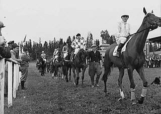
Geography and history

The district Øvrevoll was built around the farm Øvre Vold, which stems from the separation of Vold farm into two farms; Øvre and Nedre (Upper and Lower) Vold in 1721. [1] Today, Øvrevoll and Voll are sometimes referred to as one district. [2] Øvrevoll borders Jar in the south, Grav in the west, Østerås, Eiksmarka and Grini in the north and Voll in the east.

Voll is a district in eastern Bærum, Norway.

Jar, Norway Village in Østlandet, Norway

Jar is a district in the municipality of Bærum, Norway. Its population (2007) is 4,868.

Grav is a district in the municipality of Bærum, Norway. Mainly a residential area, the population (2009) is 4,463.

Contents

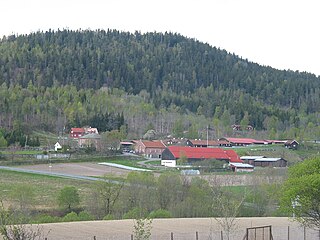
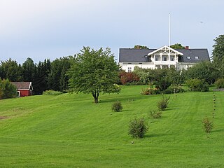
The farm had one croft under it; Lindeberg. In 1809, Øvre Vold farm was designated as the seat of the district stipendiary magistrate, but he chose to live at Øvre Stabæk instead. In 1826 the farm was registered as having 165 decares of crop, three horses, eleven cattle and twelve sheep. It had various owners until it was bought by dentist Einar Hirsch in 1910. [1] He soon started to parcel out lots, starting with the area around the farm around World War I. [2]

Croft (land) fenced or enclosed area of land

A croft is a fenced or enclosed area of land, usually small and arable, and usually, but not always, with a crofter's dwelling thereon. A crofter is one who has tenure and use of the land, typically as a tenant farmer, especially in rural areas.

Ringstabekk is a district in Bærum, Norway. Named after the local farm, the district is also known for its schools and the sports field. The sports club Stabæk IF originates in the area.

Einar von Hirsch was a Norwegian dentist and landowner.

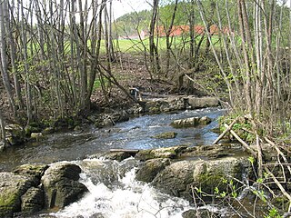
The farm's communications had been drastically improved in 1872, when the road Vollsveien from Lysaker opened. The main purpose was to aid the timber industry around the river Lysakerelva. Vollsveien was connected to Norwegian National Road 168 around 1930. [2] Since 1951 the district is served by Lijordet Station on the Røa Line, located north of the horse racing track. Øvrevoll is the name of a bus stop, served by line 131 of Ruter's bus network.

Lysaker Town in Østlandet, Norway

Lysaker is an area in Bærum Municipality, Akershus County, Norway. Lysaker is the easternmost part of Bærum and borders Oslo proper. Lysaker was initially a farming community, later becoming a residential area. Today it is primarily known as a business and trade area, and a public transport hub. It is considered part of Stor-Oslo, and is home to offices of numerous domestic and international businesses.

Norwegian National Road 168

Norwegian National Road 168 is a major route between Bærum and Oslo, Norway.

Lijordet (station) railway station in Bærum, Norway

Lijordet is a station on the Røa Line of the Oslo Metro. It is located between Østerås and Eiksmarka, 9.6 km from Stortinget. It is the second of three stations on the Røa Line within Bærum municipality.

Sports

Øvrevoll is famous as the site of Øvrevoll Galoppbane, Norway's only track for gallop horse racing. [3] The idea for establishing the track came from Einar Hirsch in 1927, [4] and approved by the central government despite local protests. [5] Construction was carried through between 1930 and 1932. In 1984 a dirt track was added to the grass track, to allow racing and training in different kinds of weather. [3] Proposals from track owners to build housing there have so far been turned down. [5]

Øvrevoll Galoppbane

Øvrevoll Galoppbane is the only gallop racecourse in Norway

Horse racing Equestrian sport

Horse racing is an equestrian performance sport, typically involving two or more horses ridden by jockeys over a set distance for competition. It is one of the most ancient of all sports, as its basic premise – to identify which of two or more horses is the fastest over a set course or distance – has been unchanged since at least classical antiquity.

The car park at the racing track was for some time used for association football and bandy by the team Øvrevollkameratene, founded on 26 April 1955. A clubhouse was raised further south at Jarmyra in 1968, and that open grass plain at Jar became their home field. The club was named Øvrevoll BK through most of its existence, and on 26 September 2007 it was merged to form Øvrevoll Hosle IL, with clubhouse at Hosle. [6]

Association football team field sport

Association football, more commonly known as football or soccer, is a team sport played with a spherical ball between two teams of eleven players. It is played by 250 million players in over 200 countries and dependencies, making it the world's most popular sport. The game is played on a rectangular field called a pitch with a goal at each end. The object of the game is to score by moving the ball beyond the goal line into the opposing goal.

Bandy ballgame on ice played using skates and sticks

Bandy is a team winter sport played on ice, in which skaters use sticks to direct a ball into the opposing team's goal.

Øvrevoll Hosle IL

Øvrevoll Hosle Idrettslag is a Norwegian multi-sports club from eastern Bærum.

Related Research Articles

Eyvind W. Wang is a Norwegian politician for the Conservative Party.

Øverlandselva

Øverlandselva is a river that flows through Bærum, Norway.

Skallum is an area at Stabekk in Bærum, Norway. It was named after the historic estate Skallum. It is known locally for its art gallery and as a recreational area, and nationally as the site of an event in the closing days of World War II in Europe.

Øverland, Bærum

Øverland is an area in Bærum, Norway. Named after the local farm, Øverland is also known as a recreational area and for its arboretum. It has lent its name to the river Øverlandselva.

Strand is a district in Bærum, Norway. Mainly a residential area, it is also known as a marine recreational site, owing to its proximity to the Oslofjord.

Håkon Stenstadvold was a Norwegian painter, illustrator, journalist, art critic and politician for the Conservative Party.

Skytterdalen

Skytterdalen is a small, populated valley north of Sandvika in Bærum, Norway.

Grini

Grini is a district in northeastern Bærum, Norway.

Ramstad is a district in central Bærum, Norway. It is known mainly for its school, and a former station on the Drammen Line.

Egil Kjølner was a Norwegian politician for the Christian Democratic Party.

Nadderud place in Norway

Nadderud is a district in eastern Bærum, Norway. It was formerly farmland under one of Bærum's larger farms, named Nadderud, but since the 1950s it has been built up with housing, several schools and sporting facilities. The best known facility, which has made the name Nadderud nationally known, is the stadium Nadderud stadion. Parts of the district Nadderud have been absorbed by the growing suburban centre Bekkestua.

Gjønnes is a district in eastern Bærum, Norway.

Idrettslaget Jardar is a Norwegian sports club from Bærum, Akershus. It covers the areas Slependen, Jong and Tanum.

Jar Idrettslag is a Norwegian sports club from Bærum, Akershus. It mainly covers the areas Jar, Lysaker and parts of Stabekk.

Frithjof Møinichen Plahte was a Norwegian merchant and landowner. After a career in the timber business, he settled in Bærum where he invested in business and in several farms. His family socialized within the upper echelon in the capital city region, and he stood behind the establishment of Høvik Church and the use of Fleskum farm by a group of painters.

Asker Seminary was a teachers' seminary at Bjerke near Tanum.

References

  1. 1 2 Bakken, Tor Chr., ed. (2008). "Vold". Budstikkas store Asker og Bærum-leksikon (in Norwegian). Oslo: Kunnskapsforlaget. p. 481. ISBN   978-82-573-1534-4.
  2. 1 2 3 Bakken, Tor Chr., ed. (2008). "Øvrevoll". Budstikkas store Asker og Bærum-leksikon (in Norwegian). Oslo: Kunnskapsforlaget. p. 502. ISBN   978-82-573-1534-4.
  3. 1 2 Bakken, Tor Chr., ed. (2008). "Øvrevoll galoppbane". Budstikkas store Asker og Bærum-leksikon (in Norwegian). Oslo: Kunnskapsforlaget. p. 502. ISBN   978-82-573-1534-4.
  4. Borgen, Per Otto (2006). "Vold Øvre". Asker og Bærum leksikon (in Norwegian). Drammen: Forlaget for by- og bygdehistorie. p. 546. ISBN   82-91649-10-3.
  5. 1 2 Borgen, Per Otto (2006). "Øvrevoll Veddeløpsbane, A/S". Asker og Bærum leksikon (in Norwegian). Drammen: Forlaget for by- og bygdehistorie. pp. 573–574. ISBN   82-91649-10-3.
  6. Bakken, Tor Chr., ed. (2008). "Øvrevoll Hosle Idrettslag". Budstikkas store Asker og Bærum-leksikon (in Norwegian). Oslo: Kunnskapsforlaget. p. 502. ISBN   978-82-573-1534-4.

Coordinates: 59°55′56″N10°37′02″E / 59.9323°N 10.6172°E / 59.9323; 10.6172

Geographic coordinate system Coordinate system

A geographic coordinate system is a coordinate system that enables every location on Earth to be specified by a set of numbers, letters or symbols. The coordinates are often chosen such that one of the numbers represents a vertical position and two or three of the numbers represent a horizontal position; alternatively, a geographic position may be expressed in a combined three-dimensional Cartesian vector. A common choice of coordinates is latitude, longitude and elevation. To specify a location on a plane requires a map projection.