Øysand

Last updated
Øysand
Village
Oysand.jpg
Øysand, with Byneset on the other side of Gaulosen, a branch of Trondheim Fjord
Norway Trondelag adm location map.svg
Red pog.svg
Øysand
Location of the village
Norway location map.svg
Red pog.svg
Øysand
Øysand (Norway)
Coordinates: 63°19′52″N10°12′56″E / 63.3312°N 10.2156°E / 63.3312; 10.2156 Coordinates: 63°19′52″N10°12′56″E / 63.3312°N 10.2156°E / 63.3312; 10.2156
Country Norway
Region Central Norway
County Trøndelag
District Gauldalen
Municipality Melhus
Elevation [1] 4 m (13 ft)
Time zone CET (UTC+01:00)
  Summer (DST) CEST (UTC+02:00)
Post Code7224 Melhus

Øysand is a small village in the northwestern part of the municipality of Melhus in Trøndelag county, Norway. The village sits on the south side of the mouth of the Gaula River, at the head of the Gaulosen, an arm off the main Trondheim Fjord.

Melhus Municipality in Trøndelag, Norway

Melhus is a municipality in Trøndelag county, Norway. It is part of the Gauldalen region. The administrative centre of the municipality is the village of Melhus. Other villages include Gåsbakken, Hovin, Korsvegen, Kvål, Ler, Lundamo, Storsand, and Øysand.

Trøndelag Region and county of Norway

Trøndelag is a county in the central part of Norway. It was created in 1687, then named Trondhjem County ; in 1804 the county was split into Nord-Trøndelag and Sør-Trøndelag, and the counties were reunited in 2018. Trøndelag county and the neighboring Møre og Romsdal county together form what is known as Central Norway.

Norway constitutional monarchy in Northern Europe

Norway, officially the Kingdom of Norway, is a Nordic country in Northwestern Europe whose territory comprises the western and northernmost portion of the Scandinavian Peninsula; the remote island of Jan Mayen and the archipelago of Svalbard are also part of the Kingdom of Norway. The Antarctic Peter I Island and the sub-Antarctic Bouvet Island are dependent territories and thus not considered part of the kingdom. Norway also lays claim to a section of Antarctica known as Queen Maud Land.

Contents

Geography

Gaulosen, a branch of Trondheim Fjord, with Oysand in the background. Photo taken from Byneset. Gaulosen og Oysand.jpg
Gaulosen, a branch of Trondheim Fjord, with Øysand in the background. Photo taken from Byneset.

The Øysand area measures about 3 square kilometers (1.2 sq mi). [2] The Gaula River borders Øysand to the north and east, separating it from Leinstrand in the municipality of Trondheim. To the west there is a shallow sandy beach on the shore of Gaulosen, a branch of Trondheim Fjord. To the south, the section of European route E39 from Klett to Orkanger crosses the area. Øysand is a flat plain and most of the land is used for growing grain. There is also some industry there and a campground along the beach. [3] The best-known native of the area is the musician, composer, and actor Ivar Gafseth, who is known from the television series The Julekalender and the Trøndelag Theater. [4]

Gaula (Trøndelag) river in Trøndelag, Norway

The Gaula is a river that flows through the Gauldal valley in Trøndelag county, Norway. The 153-kilometre (95 mi) long river is the largest in Central Norway. The river begins in Holtålen municipality near the mountain Kjølifjellet. It then flows through the municipalities of Holtålen, Midtre Gauldal, and Melhus before emptying into Trondheimsfjord near Leinstrand on the border between the municipalities of Trondheim and Melhus.

Leinstrand Former municipality in Sør-Trøndelag, Norway

Leinstrand is a former municipality in the old Sør-Trøndelag county, Norway. The 46-square-kilometre (18 sq mi) municipality existed from 1838 until its dissolution in 1964. The municipality of Leinstrand encompassed the south-central part of what is now the city of Trondheim in Trøndelag county. The administrative centre was located in Heimdal, just west of the border with Tiller municipality. The local Leinstrand Church was built in 1673.

Trondheim City in Norway

Trondheim is a city and municipality in Trøndelag county, Norway. It has a population of 193,501, and is the third-most populous municipality in Norway, although the fourth largest urban area. Trondheim lies on the south shore of Trondheim Fjord at the mouth of the River Nidelva. The city is dominated by the Norwegian University of Science and Technology (NTNU), the Foundation for Scientific and Industrial Research (SINTEF), St. Olavs University Hospital and other technology-oriented institutions.

Name

The name of the area was originally simply Øy 'island'. [2] The name Øysand is also found spelled as Øysandan and Øysanden, but these forms are hardly ever used in speech. The dative form of Øysand in the local dialect is på Øysaɲɲa. In 2012, the Norwegian Mapping and Cadastre Authority sought to standardize the spelling as Øysand. [2]

The Norwegian Mapping Authority (NMA) is Norway's national mapping agency, dealing with land surveying, geodesy, hydrographic surveying, cadastre and cartography. The current director is Anne Cathrine Frøstrup. Its headquarters are in Hønefoss and it is a public agency under the Ministry of Local Government and Modernisation. NMA was founded in 1773.

Nordstern

During the Second World War, the Germans developed plans to create a new German metropolis in Øysand called Nordstern. [5]

Nordstern (city) Nazi plan for the creation of a new German metropolis in German-occupied Norway

Nordstern, often erroneously referred to as Neu Drontheim, was the Nazi plan for the creation of a new German metropolis in German-occupied Norway during World War II. It was planned to have a population of around 250,000–300,000 inhabitants.

Related Research Articles

Skaun Municipality in Trøndelag, Norway

Skaun is a municipality in Trøndelag county, Norway. It is part of the Orkdalen region. The administrative centre of the municipality is the village of Børsa. Other villages include Buvika, Eggkleiva, Melby, Skaun, and Viggja.

Klæbu Municipality in Trøndelag, Norway

Klæbu is a municipality in Trøndelag county, Norway. It is located in the southern part of the Trondheim Region, about 20 kilometres (12 mi) south of the city of Trondheim. The administrative center is the village of Klæbu. The other major village in Klæbu municipality is Tanem.

Trondheim Fjord inlet of the Norwegian Sea in Norway

The Trondheim Fjord or Trondheimsfjorden, an inlet of the Norwegian Sea, is Norway's third-longest fjord at 130 kilometres (81 mi) long. It is located in the west-central part of the country in Trøndelag county, and it stretches from the municipality of Ørland in the west to the municipality of Steinkjer in the north, passing the city of Trondheim on its way. Its maximum depth is 617 metres (2,024 ft), between Agdenes and Indre Fosen.

Gauldal valley and district in Trøndelag, Norway

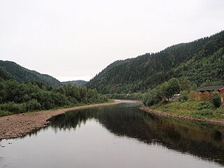
Gauldal or Gauldalen is a valley and traditional district in Trøndelag county, Norway. The river Gaula runs through the 145-kilometre (90 mi) long valley from the Røros mountains near the lake Aursunden to the Trondheimsfjorden. The narrow valley runs northwards from Røros to the Haltdalen area, where it widens some, turns and heads generally to the west to the village of Støren. At Støren it turns again and heads north through what is now a wide, agricultural valley until it reaches the sea just south of the city of Trondheim. The Rørosbanen and Dovrebanen railway lines follow the Gauldalen valley on their way to Trondheim. The European route E06 highway and the Norwegian County Road 30 also follow the valley.

Kvål, Trøndelag Village in Central Norway, Norway

Kvål is a village in the municipality of Melhus in Trøndelag county, Norway. It is located in the Gauldalen valley along the Gaula River between the villages of Ler and Melhus. The 0.42-square-kilometre (100-acre) village has a population (2017) of 464 which gives the village a population density of 1,105 inhabitants per square kilometre (2,860/sq mi).

Horg Former municipality in Sør-Trøndelag, Norway

Horg is a former municipality in the old Sør-Trøndelag county, Norway. The 291-square-kilometre (112 sq mi) municipality existed from 1841 until its dissolution in 1964. The municipality of Horg encompassed the southern part of what is now the municipality of Melhus in Trøndelag county. The municipality included areas on both sides of the river Gaula. The administrative centre was the village of Lundamo. The main church for the municipality was Horg Church.

Lundamo Village in Central Norway, Norway

Lundamo is a village in the municipality of Melhus in Trøndelag county, Norway. It is located along the Gaula River between the villages of Hovin and Ler. The 0.78-square-kilometre (190-acre) village has a population (2017) of 1,042 which gives the village a population density of 1,336 inhabitants per square kilometre (3,460/sq mi).

Hovin, Trøndelag Village in Central Norway, Norway

Hovin is a village in the municipality of Melhus in Trøndelag county, Norway. It is located along the river Gaula between the villages of Støren and Lundamo. Hovin has several distinct terraces in the hillsides, which are remnants of old shorelines following the end of the ice age.

Benna (lake) lake in Melhus, Norway

Benna is a lake in the municipality of Melhus in Trøndelag county, Norway. The 5.9-square-kilometre (2.3 sq mi) lake is located west of the river Gaula, about 3 kilometres (1.9 mi) west of the village of Lundamo. The lake is the drinking water reservoir for Melhus municipality and a backup supply for the nearby city of Trondheim.

Samsjøen (Trøndelag) lake in Sør-Trøndelag, Norway

Samsjøen is a lake in Trøndelag county, Norway. The 10-square-kilometre (3.9 sq mi) lake sits on the border of the municipalities of Midtre Gauldal and Melhus. Most of the lake lies in Midtre Gauldal, about 12 kilometres (7.5 mi) north of the village of Singsås. The lake has a dam at the northwest end, which is used for hydroelectric power production. The water flows out of the lake and into the Lundesokna river which flows into the river Gaula.

Buvik Former municipality in Sør-Trøndelag, Norway

Buvik is a former municipality in the old Sør-Trøndelag county, Norway. Buvik existed from 1855 until 1965. The municipality encompassed the extreme northeastern part of what is now the municipality of Skaun in Trøndelag county. It encompassed the roughly 25-square-kilometre (9.7 sq mi) area surrounding the Vigda river south of the Gaulosen fjord. The administrative centre was located in the village of Buvika.

Sør-Trøndelag County in Norway

Sør-TrøndelagUrban East Norwegian: [²søːrˌtrœndəlɑːɡ](listen) was a county comprising the southern portion of the present-day Trøndelag county in Norway. It bordered the old Nord-Trøndelag county as well as the counties of Møre og Romsdal, Oppland, and Hedmark. To the west is the Norwegian Sea, and to the east is Jämtland in Sweden. The county was separated into a northern and southern part by the Trondheimsfjord. Slightly over 200,000 of the county's population lives in the city of Trondheim and its suburbs. The Norwegian dialect of the region is Trøndersk.

Melhus IL Norwegian sports club

Melhus Idrettslag is a Norwegian sports club from Melhus, Sør-Trøndelag. It has sections for association football, team handball, volleyball, orienteering, Nordic skiing, weightlifting and powerlifting.

Tiller IL association football club

Tiller Idrettslag is a Norwegian sports club from Trondheim, Sør-Trøndelag. It has sections for association football, team handball, ice hockey, Nordic skiing and biathlon.

Tillerbyen FK is a Norwegian football club from Sør-Trøndelag. The club was created as a cooperation between Melhus IL and Tiller IL. The club played in the 2. Divisjon, after being promoted from the 3. Divisjon in 2013, only to return to the 3. Divisjon.

Trønderbladet is a local online and print newspaper published in Melhus, Norway. It covers the municipalities of Melhus, Skaun, Midtre Gauldal, Klæbu and the Gaulosen area of Trondheim. Published in tabloid format, the newspaper had a circulation of 5,116 in 2013. The newspaper is owned by Polaris Media. It has three weekly issues, on Tuesdays, Thursdays and Saturdays. The newspaper was founded in 1979.

Trondheim Airport, Øysand

Trondheim Airport, Øysand was a military air base situated at Øysand in Melhus, Norway. Established by Luftwaffe in 1940, remained in use throughout the Second World War, until 1945. The airfield consisted of a wooden runway measuring 1,800 by 60 meters. The airport was little used and only a squadron of meteorological observation aircraft where stationed there. Its main role thus remained as a backup of the larger air stations of Ørland and Værnes. Øysand was proposed as the site to build the German exclave Nordstern, but the plans never materialized.

Melhus (village) Village in Central Norway, Norway

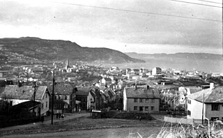
Melhus is the administrative centre of Melhus municipality in Trøndelag county, Norway. The village is located in the lower Gauldalen valley, along the river Gaula, about 15 kilometres (9.3 mi) south of the city of Trondheim. The 2.88-square-kilometre (710-acre) village has a population (2017) of 6,246 which gives the village a population density of 2,169 inhabitants per square kilometre (5,620/sq mi).

References

  1. "Øysand, Melhus (Trøndelag)". yr.no . Retrieved 2018-01-29.
  2. 1 2 3 Nakrem, Gunn Heidi (2012-02-17). "Øysand eller Øysandan?". Trønderbladet (in Norwegian).
  3. Nakrem, Gunn Heidi (2013-02-28). "I retten om Øysand camping". Trønderbladet (in Norwegian).
  4. Nakrem, Gunn Heidi (2014-11-17). "Gjensyn med The Julekalender". Trønderbladet (in Norwegian).
  5. Spotts, Frederic (2003). Hitler and the Power of Aesthetics. Woodstock: Overlook Press. p. 447. ISBN   978-1585673452.