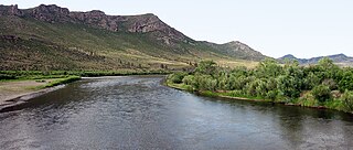
The Onon is a river in Mongolia and Russia. It is 818 km long and drains an area of 94,010 km2. It originates at the eastern slope of the Khentii Mountains. For 298 km it flows within Mongolia. It joins with Ingoda River to produce the Shilka River.
Agnew, Michigan is a tiny unincorporated community located at 42°57′54″N86°10′36″W at the intersection of U.S. Highway 31 (US 31) and M-45 in Grand Haven Charter Township of Ottawa County in the U.S. state of Michigan.

Navia de Suarna is a municipality in Lugo province in Galicia in north-west Spain.
Yodŏk County is a county in South Hamgyŏng province, North Korea. Originally part of Yŏnghŭng county, it became a separate entity as part of the 1952 reorganization of local government.

Melčice-Lieskové is a village and municipality in Trenčín District in the Trenčín Region of north-western Slovakia.

Məmmədsəfi is a village in the Kalbajar Rayon of Azerbaijan.

Wyręba is a village in the administrative district of Gmina Kiełczygłów, within Pajęczno County, Łódź Voivodeship, in central Poland. It lies approximately 2 kilometres (1 mi) south-west of Kiełczygłów, 10 km (6 mi) north of Pajęczno, and 71 km (44 mi) south-west of the regional capital Łódź.

Góra Bałdrzychowska-Kolonia is a village in the administrative district of Gmina Poddębice, within Poddębice County, Łódź Voivodeship, in central Poland. It lies approximately 7 kilometres (4 mi) south of Poddębice and 37 km (23 mi) west of the regional capital Łódź.

Brzeżanka is a village in the administrative district of Gmina Strzyżów, within Strzyżów County, Subcarpathian Voivodeship, in south-eastern Poland. It lies approximately 5 kilometres (3 mi) south of Strzyżów and 28 km (17 mi) south-west of the regional capital Rzeszów.

Pod Lasem is a village in the administrative district of Gmina Żelechów, within Garwolin County, Masovian Voivodeship, in east-central Poland. It lies approximately 4 kilometres (2 mi) west of Żelechów, 19 km (12 mi) south-east of Garwolin, and 75 km (47 mi) south-east of Warsaw.
Gutowo-Górki is a village in the administrative district of Gmina Zawidz, within Sierpc County, Masovian Voivodeship, in east-central Poland.
Osowa Łaszewska is a village in the administrative district of Gmina Siemiątkowo, within Żuromin County, Masovian Voivodeship, in east-central Poland.

Pasieka is a village in Gmina Miastko, Bytów County, Pomeranian Voivodeship, in northern Poland. It lies approximately 24 kilometres (15 mi) south-west of Bytów and 72 km (45 mi) south-west of Gdańsk.

Wierzchocina is a village in the administrative district of Gmina Lipnica, within Bytów County, Pomeranian Voivodeship, in northern Poland. It lies approximately 9 kilometres (6 mi) south-west of Lipnica, 24 km (15 mi) south-west of Bytów, and 99 km (62 mi) south-west of the regional capital Gdańsk.

Zduny is a village in the administrative district of Gmina Małdyty, within Ostróda County, Warmian-Masurian Voivodeship, in northern Poland. It lies approximately 6 kilometres (4 mi) north of Małdyty, 33 km (21 mi) north-west of Ostróda, and 53 km (33 mi) north-west of the regional capital Olsztyn.

Bačevo is a village in the municipality of Dimitrovgrad, Serbia. According to the 2002 census, the village has a population of 19 people.

Matarova is a village in the municipality of Kuršumlija, Serbia. According to the 2002 census, the village has a population of 83 people.

Belanovce is a village in the municipality of Leskovac, Serbia. According to the 2002 census, the village has a population of 600 people.

Vladimirovca is a commune in the Slobozia District of Transnistria, Moldova. It is composed of three villages: Constantinovca, Nicolscoe and Vladimirovca. It is currently under the administration of the breakaway government of the Transnistrian Moldovan Republic.
Cobble Island is an inhabited island located in Lake Chaubunagungamaug in Webster, Massachusetts. The home on the island dates back to before 1922. There is a large rock that sits at the eastern side of the island. The massive boulder is widely recognized among the town's natives and is often considered Webster's greatest fishing spot. On the island's western side there is a small cove that is often inhabited by an LA-4-200 Lake Buccaneer.


