
The Mathematical Research Institute of Oberwolfach in Oberwolfach, Germany, was founded by mathematician Wilhelm Süss in 1944.
Titus Mountain or Titus as it is colloquially known, is a popular downhill ski area spread over 3 mountains of northern New York, 7 miles (11 km) south of the Village of Malone, in the Town of Malone, in Franklin County, New York. The area has a base elevation of 825 feet (251 m), summit elevation of 2,025 feet (617 m) and a vertical drop of 1,200 feet (370 m). Titus is part of the Adirondack Mountains. In 2011, ownership passed to the Monette family of Malone.

Marijampolė Municipality is one of 60 municipalities in Lithuania.
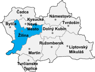
Belá is a village and municipality in Žilina District in the Žilina Region of northern Slovakia.
Pawłów Trzebnicki is a village in the administrative district of Gmina Prusice, within Trzebnica County, Lower Silesian Voivodeship, in south-western Poland. Prior to 1945 it was in Germany.

WEMY is a Christian radio station broadcasting on 91.5 FM, serving the Green Bay, Wisconsin area. The station's format consists of Christian contemporary music with some Christian talk and teaching. WEMY is also heard in the Manitowoc - Two Rivers area through a translator on 95.5.

Mochimune Station is a railway station in Suruga-ku, Shizuoka City, Shizuoka Prefecture, Japan, on the Tōkaidō Main Line. It is located 186.6 rail kilometers from Tokyo Station, and is operated by Central Japan Railway Company.

Krosnowo is a village in the administrative district of Gmina Borzytuchom, within Bytów County, Pomeranian Voivodeship, in northern Poland. It lies approximately 5 kilometres (3 mi) north of Borzytuchom, 15 km (9 mi) north-west of Bytów, and 84 km (52 mi) west of the regional capital Gdańsk.

Abjit is a former village in the Balakan Rayon of Azerbaijan. The village formed part of the municipality of Qaysa.
Piaski-Młynek is a village in the administrative district of Gmina Lututów, within Wieruszów County, Łódź Voivodeship, in central Poland.
Krzywe is a village in the administrative district of Gmina Cisna, within Lesko County, Subcarpathian Voivodeship, in south-eastern Poland, close to the border with Slovakia. It lies approximately 4 kilometres (2 mi) south-east of Cisna, 32 km (20 mi) south of Lesko, and 97 km (60 mi) south of the regional capital Rzeszów.
Huta is a village in the administrative district of Gmina Radoszyce, within Końskie County, Świętokrzyskie Voivodeship, in south-central Poland. It lies approximately 8 kilometres (5 mi) south-east of Radoszyce, 18 km (11 mi) south of Końskie, and 26 km (16 mi) north-west of the regional capital Kielce.
Piotrów is a village in the administrative district of Gmina Waśniów, within Ostrowiec County, Świętokrzyskie Voivodeship, in south-central Poland. It lies approximately 3 kilometres (2 mi) north of Waśniów, 12 km (7 mi) west of Ostrowiec Świętokrzyski, and 44 km (27 mi) east of the regional capital Kielce.
Pasztowa Wola-Kolonia is a village in the administrative district of Gmina Rzeczniów, within Lipsko County, Masovian Voivodeship, in east-central Poland.
Komorowo is a village in the administrative district of Gmina Wyrzysk, within Piła County, Greater Poland Voivodeship, in west-central Poland. It lies approximately 5 kilometres (3 mi) south-west of Wyrzysk, 34 km (21 mi) east of Piła, and 82 km (51 mi) north of the regional capital Poznań.
Wojsław is a village in the administrative district of Gmina Grodków, within Brzeg County, Opole Voivodeship, in south-western Poland. It lies approximately 5 kilometres (3 mi) north of Grodków, 18 km (11 mi) south-west of Brzeg, and 42 km (26 mi) west of the regional capital Opole.
Warszkajty is a former village in the administrative district of Gmina Górowo Iławeckie, within Bartoszyce County, Warmian-Masurian Voivodeship, in northern Poland, directly at the border to the Kaliningrad Oblast of Russia. It lies approximately 15 kilometres (9 mi) north-east of Górowo Iławeckie, 17 km (11 mi) north-west of Bartoszyce, and 65 km (40 mi) north of the regional capital Olsztyn.
Nowy Suchoros is a village in the administrative district of Gmina Rozogi, within Szczytno County, Warmian-Masurian Voivodeship, in northern Poland. It lies approximately 22 kilometres (14 mi) south of Rozogi, 20 km (12 mi) south-east of Szczytno, and 60 km (37 mi) south-east of the regional capital Olsztyn.
Sarkin Yamma is a village and rural commune in Niger.

Miranovačka Kula is a village in the municipality of Bela Palanka, Serbia. According to the 2002 census, the village has a population of 17 people. The main industry is agriculture, including wool production.


