Łagiewniki-Borek Fałęcki

Last updated
Łagiewniki-Borek Fałęcki
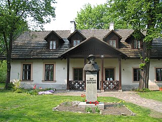
Krakow, Sanktuarium Bozego Milosierdzia - fotopolska.eu (214721).jpg
Krakow dzielnica IX Lagiewniki.svg
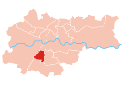
Location of Łagiewniki-Borek Fałęcki within Kraków
Coordinates: 50°0′59.3″N19°55′15.9″E / 50.016472°N 19.921083°E / 50.016472; 19.921083 Coordinates: 50°0′59.3″N19°55′15.9″E / 50.016472°N 19.921083°E / 50.016472; 19.921083
CountryFlag of Poland.svg  Poland
Voivodeship Lesser Poland
County/City Kraków
Government
  President Jan Pietras
Area
  Total5.42 km2 (2.09 sq mi)
Population
(2014)
  Total14,859
  Density2,700/km2 (7,100/sq mi)
Time zone UTC+1 (CET)
  Summer (DST) UTC+2 (CEST)
Area code(s) +48 12
Website http://www.dzielnica9.krakow.pl

Łagiewniki-Borek Fałęcki is one of 18 districts of Kraków, located in the southern part of the city. The name Łagiewniki-Borek Fałęcki comes from two villages that are now parts of the district.

In the Polish system of local administration, a dzielnica is an administrative subdivision or quarter of a city or town. A dzielnica may have its own elected council, and those of Warsaw each have their own mayor (burmistrz). Like the osiedle and sołectwo, a dzielnica is an auxiliary unit of a gmina. These units are created by decision of the gmina council, and do not have legal personality in their own right.

Kraków Place in Lesser Poland, Poland

Kraków, also spelled Cracow or Krakow, is the second largest and one of the oldest cities in Poland. Situated on the Vistula River in the Lesser Poland region, the city dates back to the 7th century. Kraków was the official capital of Poland until 1596 and has traditionally been one of the leading centres of Polish academic, economic, cultural and artistic life. Cited as one of Europe's most beautiful cities, its Old Town was declared a UNESCO World Heritage Site.

Contents

According to the Central Statistical Office data, the district's area is 5.42 square kilometres (2.09 square miles) and 14 859 people inhabit Łagiewniki-Borek Fałęcki. [1]

Central Statistical Office (Poland) Polands principal government institution in charge of statistics and census data

Statistics Poland is Poland's chief government executive agency charged with collecting and publishing statistics related to the country's economy, population, and society, at the national and local levels. The president of Statistics Poland reports directly to the Prime Minister of Poland and is considered the equivalent of a Polish government minister.

Subdivisions of Łagiewniki-Borek Fałęcki

Łagiewniki-Borek Fałęcki is divided into smaller subdivisions (osiedles). Here's a list of them.

Osiedle is a term used in Poland to denote a designated subdivision of a city or town, or of a dzielnica, with its own council and executive. Like the dzielnica and sołectwo, an osiedle is an auxiliary unit of a gmina. These units are created by decision of the gmina council, and do not have legal personality in their own right. In the case of an urban-rural gmina, it is also possible for a whole town to be designated an auxiliary unit.

Related Research Articles

Gmina Abramów Gmina in Lublin, Poland

Gmina Abramów is a rural gmina in Lubartów County, Lublin Voivodeship, in eastern Poland. Its seat is the village of Abramów, which lies approximately 20 kilometres (12 mi) west of Lubartów and 29 km (18 mi) north-west of the regional capital Lublin.

Gmina Adamów, Łuków County Gmina in Lublin, Poland

Gmina Adamów is a rural gmina in Łuków County, Lublin Voivodeship, in eastern Poland. Its seat is the village of Adamów, which lies approximately 21 kilometres (13 mi) south-west of Łuków and 60 km (37 mi) north of the regional capital Lublin.

Gmina Adamówka is a rural gmina in Przeworsk County, Subcarpathian Voivodeship, in south-eastern Poland. Its seat is the village of Adamówka, which lies approximately 26 kilometres (16 mi) north-east of Przeworsk and 56 km (35 mi) north-east of the regional capital Rzeszów.

Gmina Aleksandrów, Lublin Voivodeship Gmina in Lublin, Poland

Gmina Aleksandrów is a rural gmina in Biłgoraj County, Lublin Voivodeship, in eastern Poland. Its seat is the village of Aleksandrów, which lies approximately 16 kilometres (10 mi) south-east of Biłgoraj and 91 km (57 mi) south of the regional capital Lublin.

Prądnik Czerwony Dzielnica of Kraków in Lesser Poland, Poland

Prądnik Czerwony is one of 18 districts of Kraków; known as Dzielnica III, located in the northern part of the city. The name Prądnik Czerwony comes from a village of same name that is now a part of the district.

Prądnik Biały Dzielnica of Kraków in Lesser Poland, Poland

Prądnik Biały is one of 18 districts of Kraków, located in the northwest part of the city. The name Prądnik Biały comes from a village of same name that is now a part of the district.

Krowodrza Dzielnica of Kraków in Lesser Poland, Poland

Krowodrza is one of 18 districts of Kraków, located in the western part of the city. The name Krowodrza comes from a village of same name that is now a part of the district.

Czyżyny Dzielnica of Kraków in Lesser Poland, Poland

Czyżyny is one of 18 districts of Kraków, located in the central part of the city. The name Czyżyny comes from a village of same name that is now a part of the district.

Mistrzejowice Dzielnica of Kraków in Lesser Poland, Poland

Mistrzejowice is one of the 18 districts of Kraków; known as Dzielnica XV, located in the northern part of the city. The name Mistrzejowice comes from a village of same name that is now a part of the district.

Wzgórza Krzesławickie Dzielnica of Kraków in Lesser Poland, Poland

Wzgórza Krzesławickie is one of 18 districts of Kraków, located in the northeast part of the city. The name Wzgórza Krzesławickie comes from a village named Krzesławice that is now a part of the district.

Podgórze Duchackie Dzielnica of Kraków in Lesser Poland, Poland

Podgórze Duchackie is one of 18 districts of Kraków, located in the southern part of the city. The name Podgórze Duchackie comes from two villages that are now parts of the district.

Bieżanów-Prokocim Dzielnica of Kraków in Lesser Poland, Poland

Bieżanów-Prokocim is one of 18 districts of Kraków, located in the southeast part of the city. The name Bieżanów-Prokocim comes from two villages that are now parts of the district.

Łagiewniki may refer to:

Gmina Andrychów is an urban-rural gmina in Wadowice County, Lesser Poland Voivodeship, in southern Poland. Its seat is the town of Andrychów, which lies approximately 13 kilometres (8 mi) west of Wadowice and 49 km (30 mi) south-west of the regional capital Kraków.

Grzegórzki (Kraków) Dzielnica of Kraków in Lesser Poland, Poland

Grzegórzki is one of 18 districts of Kraków, located in the central part of the city. The name Grzegórzki comes from a village of same name that is now a part of the district.

Bronowice (Kraków) Dzielnica of Kraków in Lesser Poland, Poland

Bronowice is one of 18 districts of Kraków, located in the western part of the city. The name Bronowice comes from a village of same name that is now a part of the district.

Zwierzyniec (Kraków) Dzielnica of Kraków in Lesser Poland, Poland

Zwierzyniec is one of 18 districts of Kraków, located in the western part of the city. The name Zwierzyniec comes from a village of same name that is now a part of the district.

Dębniki (Kraków) Dzielnica of Kraków in Lesser Poland, Poland

Dębniki is one of 18 districts of Kraków, located in the southwest part of the city. The name Dębniki comes from a village of same name that is now a part of the district.

Swoszowice (Kraków) Dzielnica of Kraków in Lesser Poland, Poland

Swoszowice is one of 18 districts of Kraków, located in the southern part of the city. The name Swoszowice comes from a village of same name that is now a part of the district.

Bieńczyce (Kraków) Dzielnica of Kraków in Lesser Poland, Poland

Bieńczyce is one of 18 districts of Kraków, located in the northern part of the city. The name Bieńczyce comes from a village of same name that is now a part of the district.

References

  1. "Information about Łagiewniki-Borek Fałęcki district". Biuletyn Informacji Publicznej. Retrieved 30 August 2017.