Foshan Prison is a prison in the Gaoming District of Foshan City, Guangdong Province, China. The prison was established as Xijiang Mengjiang Laogai Farm in 1958 and took the name of Foshan Prison in 1995. Prisoners once mined ore at the adjacent Fuwan Xijiang Manganese Mine (富湾西江锰矿), where deposits are now exhausted such that prisoner activity now involves industrial production of rattan and wool goods.

Paired amphipathic helix protein Sin3b is a protein that in humans is encoded by the SIN3B gene.
Elgeyo escarpment is a fault-scarp caused by post-Miocene faulting. Miocene beds are still visible. The escarpment is part of the western wall of the Great Rift Valley.
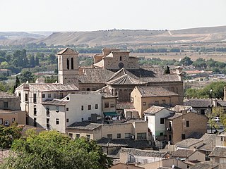
Santiago del Arrabal is a church in Toledo, Spain, built in 1245–48, at the orders of Sancho II, on the site of an older church and a mosque that is known to have been used since 1125. Many characteristics of the mosque have remained in the present building which is built in the Mudéjar architectural style. The church is named after Saint James (Santiago) of the outskirts (Arrabal). The patrons of the church during its foundation were members of the Diosdado family, knight commanders of the Order of Santiago.

Ciepłowo is a village in the administrative district of Gmina Wierzbinek, within Konin County, Greater Poland Voivodeship, in west-central Poland. It lies approximately 6 kilometres (4 mi) south-west of Wierzbinek, 25 km (16 mi) north-east of Konin, and 104 km (65 mi) east of the regional capital Poznań.
Dobra Wola is a village in the administrative district of Gmina Wierzbinek, within Konin County, Greater Poland Voivodeship, in west-central Poland.
Julianowo is a village in the administrative district of Gmina Wierzbinek, within Konin County, Greater Poland Voivodeship, in west-central Poland.
Katarzynowo is a village in the administrative district of Gmina Wierzbinek, within Konin County, Greater Poland Voivodeship, in west-central Poland.
Kolonia Racięcka is a village in the administrative district of Gmina Wierzbinek, within Konin County, Greater Poland Voivodeship, in west-central Poland.
Leszczyc is a village in the administrative district of Gmina Wierzbinek, within Konin County, Greater Poland Voivodeship, in west-central Poland.
Pagórki is a village in the administrative district of Gmina Wierzbinek, within Konin County, Greater Poland Voivodeship, in west-central Poland.
Wojciechowo is a village in the administrative district of Gmina Wierzbinek, within Konin County, Greater Poland Voivodeship, in west-central Poland.
Wójcinek is a village in the administrative district of Gmina Wierzbinek, within Konin County, Greater Poland Voivodeship, in west-central Poland.

Rhônexpress is an express tram-train service which links central Lyon, France, with its airport, Lyon-Saint Exupéry Airport, and the TGV train station located there.
Estadio Municipal Juan Rojas is a rugby stadium in Almería, Spain. It was initially used as the stadium of football club AD Almería as well as UD Almería matches until it was replaced by Estadio de los Juegos Mediterráneos in 2004. The capacity of the stadium is 13,468 spectators.

Edgware Bus Station serves the Edgware suburb of the London Borough of Barnet, Greater London, England. The station is owned and maintained by Transport for London.
Huimilpan (municipality) is a municipality in Querétaro in central Mexico.

Camp Verde Unified School District (CVUSD) is a school district with headquarters in Camp Verde, Arizona. The district is about 40 miles (64 km) east of Prescott.
A centered dodecahedral number is a centered figurate number that represents a dodecahedron. The centered dodecahedral number for a specific n is given by
Linden Park, officially known as Park of the Americas, is a 3.08-acre (1.25 ha) park located in the center of the Corona neighborhood of Queens, New York. It has stood out as a green square block on maps since the village of West Flushing was first mapped out in 1853, long before the village became the suburb or urban neighborhood known as Corona.


