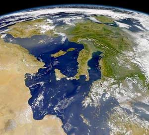
Italy is located in southern Europe and comprises the long, boot-shaped Italian Peninsula, the southern side of Alps, the large plain of the Po Valley and some islands including Sicily and Sardinia. Corsica, although belonging to the Italian geographical region, has been a part of France since 1769. Italy is part of the Northern Hemisphere.

Čiekurkalns is neighbourhood of Northern District in Riga, the capital of Latvia. It is located on the southwestern shore of Lake Ķīšezers
Quintanilla de la Mata is a municipality and town located in the province of Burgos, Castile and León, Spain. According to the 2004 census (INE), the municipality has a population of 157 inhabitants.
Straußfurt is a Verwaltungsgemeinschaft in the district of Sömmerda, in Thuringia, Germany. The seat of the Verwaltungsgemeinschaft is in Straußfurt.

Pogăceaua is a commune in Mureș County, Romania composed of ten villages: Bologaia (Balogéja), Ciulea (Csulja), Deleni (Ökröstó), Fântâna Babii, Pârâu Crucii, Pogăceaua, Scurta, Sicele, Valea Sânpetrului and Văleni.

Verin Akhtala is a village in the Lori Province of Armenia. In 1995 it became part of the nearby community of Shamlugh.

Olcea is a commune in Bihor County, northwestern Romania with a population of 2,773 people. It is composed of four villages: Călacea (Bélkalocsa), Hodișel (Pusztahodos), Olcea and Ucuriș (Ökrös).

Tân Duyệt is a commune (xã) and village in Đầm Dơi District, Cà Mau Province, in Vietnam.

Kačice is a village and municipality in Kladno District in the Central Bohemian Region of the Czech Republic.
The Pourakino River is a river in New Zealand, flowing into the Jacobs River Estuary at Riverton.
Orbányosfa is a village in Zala County, Hungary.
Zalaistvánd is a village in Zala County, Hungary.
Rannapungerja is a village in Alutaguse Parish, Ida-Viru County in northeastern Estonia.

Barnett Glacier is a large glacier in the Anare Mountains that flows east along the south side of Tapsell Foreland into Smith Inlet, northern Victoria Land, Antarctica. It was mapped by the United States Geological Survey (USGS) from surveys and from U.S. Navy air photos, 1960–63, and named by the Advisory Committee on Antarctic Names after Donald C. Barnett, USGS topographic engineer, a member of USGS Topo East and West, 1962–63, in which the expedition extended geodetic control from the area of Cape Hallett to the Wilson Hills and from the foot of Beardmore Glacier through the Horlick Mountains. The glacier lies on the Pennell Coast, a portion of Antarctica lying between Cape Williams and Cape Adare.
Proletarsk is the name of several inhabited localities in Russia.
Rankuh District is a district (bakhsh) in Amlash County, Gilan Province, Iran. At the 2006 census, its population was 16,392, in 4,619 families. The District has one city: Rankuh. The District has three rural districts (dehestan): Kojid Rural District, Shabkhus Lat Rural District, and Somam Rural District.
Bukit Ibam is a small town in Rompin constituency, Pahang, Malaysia.
Andreyevo is the name of several rural localities in Russia.

German submarine U-1170 was a Type VIIC/41 U-boat of Nazi Germany's Kriegsmarine during World War II.


