
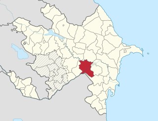
Aghjabadi is a rayon in central Azerbaijan with an administrative center in the town of Aghjabadi.

Aghstafa is a rayon in the northwestern Azerbaijan.It has two farmland exclaves inside Armenia, Jaradollo both of which came under Armenian control during the Nagorno-Karabakh War.

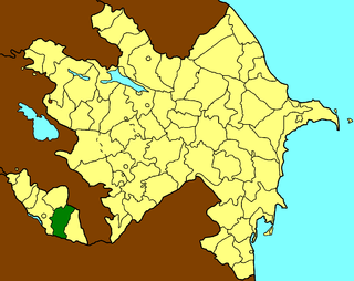
Astara is the southernmost rayon in southeastern Azerbaijan.

Balakan is a rayon of northwestern Azerbaijan, located between Georgia and Russia. It borders Kakheti of Georgia to south and west and Dagestan of Russia to east and north. There is an Azerbaijan-Georgia border crossing at Postbina in the rayon that is open to both local residents and foreigners.
Imishli (İmişli) is a rayon of Azerbaijan. Imishli and neighbouring Sabirabad rayon share Sarysu, the largest lake in Azerbaijan.

The District of Qusar is an administrative unit in the northern part of Azerbaijan. Its administrative center is Qusar city.

Shamkir is a rayon in Azerbaijan. It is located in the northwestern part of the Azerbaijan Republic. The rayon was previously called "Shamkhor" during the Soviet rule and was renamed to Shamkir only in 1991 after restoration of independence of Azerbaijan. The district was established in 1930. The capital of Shamkir Rayon is Shamkir city.

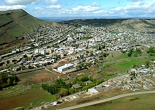
Daşkəsən is a city and municipality in and the capital of the Dashkasan Rayon of modern Azerbaijan. It has a population of 10 801. The municipality consists of the city of Daşkəsən and the village of Alunitdağ.

Karki or Tigranashen is a village that is de jure an exclave of the Nakhchivan Autonomous Republic of Azerbaijan. The village is near the border with Armenia, located on the bank of the Arpachay River near the Yerevan-Jermuk highway, which is 15 kilometres (9.3 mi) away from the district center. The area of the village itself is 950 hectares. Karki is de jure within the administrative territory of the Sadarak Rayon of Nakhchivan. It was occupied on January 19, 1990, by Armenian forces.
Julfa is a rayon of Azerbaijan in the Nakhchivan Autonomous Republic. Its borders upon Armenia in the North-East, and Iran in the South. Its area is 1000 km2. It has a population of 41,195. There are 1 city and 22 villages in the rayon. Established in 1930 and initially named as Abrakunus rayon, it has been called Julfa rayon since 1950. Julfa city is the rayon's capital. The names, Jolfa/Julfa are also used for several regions in neighboring Iran.
Germi is a city in and the capital of Germi County, Ardabil Province, Iran.

Xələc is a village and municipality in the Sharur Rayon of Nakhchivan, Azerbaijan. It is located near the Khalaj Mount, 8 km in the north-west from the district center, on the bank of the Aras River. Its population is mainly busy with farming. There are secondary school, kindergarten, library, club and a medical center in the village. It has a population of 1,268.
Bijo is a village and municipality in the Aghsu district of the Republic of Azerbaijan. It has a population of 1,860 as of 2012
Maştağa is a settlement and municipality in Baku, Azerbaijan. It has a population of 42,196.
Hovari is a village in the Lerik Rayon of Azerbaijan. The village forms part of the municipality of Şonacola. The village contains a necropolis dating from the late Bronze Age to early Iron Age.
Aşağı Daşarx is a village and municipality in the Sharur District of Nakhchivan Autonomous Republic, Azerbaijan. It is located in the left side of the Nakhchivan-Sadarak highway, 14 km away from the district center, on the plain. Its population is busy with beet-growing and vegetable-growing. There are secondary school, library, club and a medical center in the village. It has a population of 663.
Havuş is a village and municipality in the Sharur District of Nakhchivan Autonomous Republic, Azerbaijan. It is located 35 km in the west from the district center, in about 2,000 meters above sea level, on the slope of the Daralayaz ridge, the border with Armenia. There are secondary school, club and a medical center in the village. It has a population of 114. In the its territory are located the settlement of Tamaşalı and cemetery of the Middle Ages.
İbadulla is a village and municipality in the Sharur District of Nakhchivan Autonomous Republic, Azerbaijan. It is located 10 km in the south from the district center, on the bank of the Arpachay River, on the plain. Its population is busy with farming and animal husbandry. There are secondary school, library, club and a medical center in the village. It has a population of 1,365. The Şortəpə settlement of the Bronze Age has been found in the area.
Sabirkənd is a village and municipality in the Ordubad Rayon of Nakhchivan, Azerbaijan. It is located in the right side of the Ordubad-Nakhchivan highway, 23 km in the north-west from the district center, on the right bank of the Aras river. Its population is busy with gardening, vegetable-growing, farming and animal husbandry. There are secondary school, club, library and a medical center in the village. It has a population of 1,028.

Tuba Shahi Mosque is located in Mardakan township of Baku. It is an architectural monument of Azerbaijan and is a cultic construction, which was spread in architecture of the northern regions of Azerbaijan. The mosque was constructed in the 15th century and was named in honor of the woman who ordered its construction.


