
Smygehuk is a harbour and fishing village at Smygehamn in Skåne, Sweden. It is most known for being the southernmost point of Sweden, and the entire Scandinavian Peninsula. To the west of the harbour are Smygehuk Lighthouse and Smygehuk Hostel.

Groß Iser was a village on Hala Izerska existing from the 17th century until 1945. Today the remains of the village can be found in Poland just by the Czech border. The closest towns are Świeradów-Zdrój on the Polish side and Harrachov on the Czech side.

Upinniemi is a village in the municipality of Kirkkonummi in southern Finland. It is located approximately 12 km south of the municipal centre.
The Rural Municipality of Blanshard is a former rural municipality (RM) in the Canadian province of Manitoba. It was originally incorporated as a rural municipality on December 22, 1883. It ceased on January 1, 2015 as a result of its provincially mandated amalgamation with the RM of Saskatchewan and the Town of Rapid City to form the Rural Municipality of Oakview.
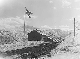
Mjølfjell Station is a railway station along the Bergen Line in the village of Mjølfjell in the eastern part of the Raundalen valley in Voss municipality, Vestland county, Norway. The station is served by the Bergen Commuter Rail, operated by Vy Tog, with up to five daily departures in each direction, in addition to one weekly express train. The station was opened in 1908. The surrounding area is dominantly recreational, with many cabins. It is accessible by a spur of County Road 307. The station takes its name from the nearby mountain Mjølfjellet.
Sizavet is a village in the Ashotsk Municipality of the Shirak Province of Armenia.
Ağtəpə is a village in Jabrayil Rayon of Azerbaijan. On 20 October 2020, President of Azerbaijan Ilham Aliyev claimed Azerbaijani forces had liberated the village from Armenian occupation, though this has not yet been corroborated by third-party sources.

Družetić is a village in Serbia. It is situated on the banks of the Ub river in the Koceljeva municipality, in the Mačva District of Central Serbia. The village had a Serb ethnic majority and a population of 501 in 2002.
Majwal is a village in the Kotli District of Azad Kashmir, Pakistan. Neighbouring settlements include Bindian and Giran.
Farako is a small town and commune in the Cercle of Kolondieba in the Sikasso Region of southern Mali. In 1998 the commune had a population of 9,769.

The Chocolay River is a 21.7-mile-long (34.9 km) tributary of Lake Superior in Marquette County on the Upper Peninsula of Michigan in the United States. It forms at the confluence of its West and East Branches west of Skandia and flows generally north, then west, to Lake Superior at the village of Harvey, 3 miles (5 km) southeast of the city of Marquette.

The Cider Museum is located in the Plaza del Príncipe de Asturias in Nava, Asturias, Spain. Opened in 1996 by Prince Philip, it is a themed museum that showcases Asturian national drink, cider. The museum is a member of the Ethnographic Museums Network of Asturias.
Bogujevac is a village in the municipality of Kuršumlija, Serbia. According to the 2002 census, the village has a population of 84 people.
Međa is a village in the municipality of Leskovac, Serbia. According to the 2002 census, the village has a population of 872 people.

Stadio Tre Fontane is a sports stadium located in Rome, Italy. It is the home ground of rugby union side Rugby Roma Olimpic, who play in the Super 10 competition. It currently has a capacity of 4,000, although there are plans to redevelop and expand the stadium.
Tamme is a village in Võru Parish, Võru County in southeastern Estonia.
Leskovac is a village situated in Petrovac na Mlavi municipality in Serbia.
Mato Alto is a region of Rio de Janeiro, but not officially recognized as a neighborhood.
Bwendero Sugar Factory (BSF) is a sugar manufacturing establishment, under development in the Western Region of Uganda.
