Żmigródek

Last updated
Żmigródek
Village
Country Flag of Poland.svg  Poland
Voivodeship Lower Silesian
County Trzebnica
Gmina Żmigród

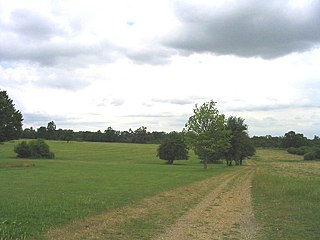
Żmigródek [ʐmiˈɡrudɛk] (German : Schmiegrode) is a village in the administrative district of Gmina Żmigród, within Trzebnica County, Lower Silesian Voivodeship, in south-western Poland. [1]

German language West Germanic language

German is a West Germanic language that is mainly spoken in Central Europe. It is the most widely spoken and official or co-official language in Germany, Austria, Switzerland, South Tyrol (Italy), the German-speaking Community of Belgium, and Liechtenstein. It is also one of the three official languages of Luxembourg and a co-official language in the Opole Voivodeship in Poland. The languages which are most similar to German are the other members of the West Germanic language branch: Afrikaans, Dutch, English, the Frisian languages, Low German/Low Saxon, Luxembourgish, and Yiddish. There are also strong similarities in vocabulary with Danish, Norwegian and Swedish, although those belong to the North Germanic group. German is the second most widely spoken Germanic language, after English.

Gmina Żmigród is an urban-rural gmina in Trzebnica County, Lower Silesian Voivodeship, in south-western Poland. Its seat is the town of Żmigród, which lies approximately 22 kilometres (14 mi) north-west of Trzebnica, and 40 kilometres (25 mi) north of the regional capital Wrocław.

Trzebnica County County in Lower Silesian, Poland

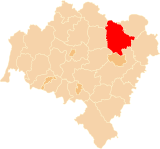
Trzebnica County is a unit of territorial administration and local government (powiat) in Lower Silesian Voivodeship, south-western Poland. It came into being on January 1, 1999, as a result of the Polish local government reforms passed in 1998. The county covers an area of 1,025.5 square kilometres (395.9 sq mi). Its administrative seat is Trzebnica, and it also contains the towns of Oborniki Śląskie, Żmigród and Prusice.

Related Research Articles

Geography of France

The geography of France consists of a terrain that is mostly flat plains or gently rolling hills in the north and west and mountainous in the south and the east.

Jubilee line London Underground line

The Jubilee line is a London Underground line that runs between Stratford in east London and Stanmore in the suburban north-west, via the Docklands, South Bank and West End. Opened in 1979, it is the newest line on the network, although some sections of track date back to 1932 and some stations to 1879.

European route E22 European road route from Wales to Russia

The European route E 22 is one of the longest European routes. It has a length of about 5,320 km (3,310 mi). Many of the E-roads have been extended into Asia since the year 2000; the E 22 was extended on 24 June 2002.

Jalalpur Town in Uttar Pradesh, India

Jalalpur is a town and a municipal board in Ambedkar Nagar district in the Indian state of Uttar Pradesh.

Advanced Landing Ground

Advanced Landing Grounds (ALGs) were temporary advance airfields constructed by the Allies during World War II during the liberation of Europe. They were built in the UK prior to the invasion and thereafter in northwest Europe from 6 June 1944 to V-E Day, 7 May 1945.

District Department of Transportation government agency

The District Department of Transportation (DDOT) is an agency of the government of the District of Columbia which manages and maintains publicly owned transportation infrastructure in the District of Columbia. DDOT is the lead agency with authority over the planning, design, construction, and maintenance of alleys, bridges, sidewalks, streets, street lights, and traffic signals in the District of Columbia.

Alsónemesapáti is a village in Zala County, Hungary.

Hottó is a village in Zala County, Hungary.

Orbányosfa is a village in Zala County, Hungary.

Pusztaszentlászló is a village in Zala County, Hungary.

Salomvár is a village in Zala County, Hungary.

Sárhida is a village in Zala County, Hungary.

Semjénháza is a village in Zala County, Hungary.

A Tjasker is a type of small drainage windmill used in the Netherlands and Germany. There are 28 tjaskers remaining the Netherlands.

Dagnam Park park in London, named after the manor house

Dagnam Park is a public park located in Harold Hill in the London Borough of Havering.

Melk Melk is a village in Jolgah Rural District, in the Central District of Jahrom County, Fars Province, Iran. At the 2006 census, its existence was noted, but its population was not reported.

Black Horse, Stepney Tower Hamlets, Greater London, E1

The Black Horse was formerly a pub at 168 Mile End Road, Stepney, London E1.

West Ham station attack

The West Ham station attack was a bomb and shooting incident at West Ham station in east London on 15 March 1976. A 5 lb bomb on a Metropolitan line train exploded prematurely in the front carriage of the train, injuring seven passengers. The bomb detonated prior to reaching the City of London, where it was thought the intended target was Liverpool Street station at rush hour. The suspect, Adrian Vincent Donnelly, a Provisional Irish Republican Army (IRA) terrorist, then shot Peter Chalk, a Post Office engineer, in the chest. He then shot and killed the train's driver Julius Stephen, who had attempted to catch him. Donelly exited the station to the street and threatened people with his revolver before PC Raymond Kiff caught up with him. Shouting "You English bastards!", Donelly shot himself in the chest, but he survived and was apprehended by Kiff.

References

  1. "Central Statistical Office (GUS) TERYT (National Register of Territorial Land Apportionment Journal)" (in Polish). 2008-06-01.

Coordinates: 51°29′16″N16°55′02″E / 51.487761°N 16.917194°E / 51.487761; 16.917194

Geographic coordinate system Coordinate system

A geographic coordinate system is a coordinate system that enables every location on Earth to be specified by a set of numbers, letters or symbols. The coordinates are often chosen such that one of the numbers represents a vertical position and two or three of the numbers represent a horizontal position; alternatively, a geographic position may be expressed in a combined three-dimensional Cartesian vector. A common choice of coordinates is latitude, longitude and elevation. To specify a location on a plane requires a map projection.