
The Zlatibor District is one of eight administrative districts of Šumadija and Western Serbia. It is located in the western, mountainous part of Serbia. The district was named after the mountain region of Zlatibor. According to the 2011 census results, the Zlatibor District has a population of 286,549 people. The administrative center of the Zlatibor district is Užice.
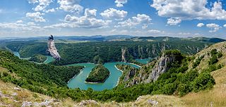
The Uvac is an international trans-boundary river, rising under Golija mountain and Pešter plateau, then flowing through southwestern Serbia and cross into eastern Bosnia and Herzegovina where, after 115 km, finally meets the Lim river from the right, however, before it empties into the Lim, for a 10 kilometers Uvac forms the border between two countries. Also, while meandering through Serbia, Uvac loosely makes the northern border of the Raška region too.

Sjenica Airport, also known as Dubinje Airport is a military airport in Serbia, near the town of Sjenica on Pešter plateau. The airport is also near to the mountain resort Zlatar. The airport will be reconstructed to be operational for civil service.

Islam spread to Serbia during the five centuries of Ottoman rule. The Muslims in Serbia are mostly ethnic Bosniaks, Albanians and minor but significant part of Roma people as well as members of the smaller ethnic groups Muslims by nationality and Gorani.
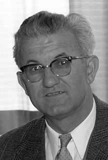
Petar Stambolić was a Yugoslav communist politician who served as the President of the Federal Executive Council of Yugoslavia from 1963 to 1967 and President of the Presidency of Yugoslavia from 1982 until 1983.

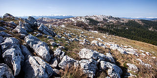
The Pešter plateau, or simply Pešter, is a karst plateau in southwestern Serbia, in the Raška region. It lies at the altitude of 1150–1492 m, at 1492 meters. The territory of the plateau is mostly located in the municipality of Sjenica, with parts belonging to Novi Pazar and Tutin. The name of the region comes from the word pešter, which is a slavic word for cave.
Sušica or Sushitsa may refer to several places:

Jadovnik is a mountain in southwestern Serbia, on the western edge of Pešter plateau, between towns of Prijepolje and Sjenica. Its highest peak Katunić has an elevation of 1,734 meters above sea level.

Ninaja is a mountain in southwestern Serbia, between cities of Novi Pazar and Sjenica. Its highest peak Homar has an elevation of 1,462 meters above sea level.
Hum is a mountain on the border of Serbia and Montenegro, between towns of Sjenica and Rožaje, on the eastern edge of Pešter plateau. Its highest peak Krstača has an elevation of 1,756 meters above sea level.
Giljeva is a mountain in southwestern Serbia, on the western edge of Pešter plateau, near the town of Sjenica. Its highest peak Jelenak has an elevation of 1,617 m (5,305 ft) above sea level.
Javor is a mountain in central Serbia, between towns of Sjenica and Ivanjica. Its highest peak Vasilin vrh has an elevation of 1,519 meters above sea level.
Ozren(Serbian Cyrillic: Озрен, pronounced [ɔ̂zrɛn]) is a mountain in southwestern Serbia, near the town of Sjenica. Its highest peak Orlovača has an elevation of 1,693 meters above sea level. It is one of the mountains which surround the Pešter plateau. Spring of the Uvac river is located at the foothills of Ozren.
SS-Polizei Selbstschutz Regiment Sandschak, known in Serbian as Krempler Legion was a Schutzstaffel (SS) unit established on the territory of Sandžak by the senior Waffen-SS officer Karl von Krempler in Axis occupied Yugoslavia. He went to the Sandžak region in October and took over the local volunteer militia of around 5,000 anti-communist, anti-Serb Muslim men headquartered in Sjenica.
The Battle of Sjenica was a battle between attacking forces of Yugoslav Partisans on one side and defending forces of the Sandžak Muslim militia and town's militsiya in Sjenica, on the territory of the Italian governorate of Montenegro.
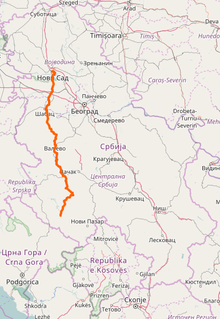
State Road 21 is an IB-class road in northern and western Serbia, connecting Novi Sad with Sjenica. It is in Vojvodina and Šumadija and Western Serbia regions.

There are several regional types of Serbian cheeses, such as the Sjenica, Zlatar, Svrljig and Homolje cheeses.


