| |||
|---|---|---|---|
| +... | |||
| 1606 in science |
|---|
| Fields |
| Technology |
| Social sciences |
| Paleontology |
| Extraterrestrial environment |
| Terrestrial environment |
| Other/related |
The year 1606 in science and technology involved some significant events.
| |||
|---|---|---|---|
| +... | |||
| 1606 in science |
|---|
| Fields |
| Technology |
| Social sciences |
| Paleontology |
| Extraterrestrial environment |
| Terrestrial environment |
| Other/related |
The year 1606 in science and technology involved some significant events.

1606 (MDCVI) was a common year starting on Sunday of the Gregorian calendar and a common year starting on Wednesday of the Julian calendar, the 1606th year of the Common Era (CE) and Anno Domini (AD) designations, the 606th year of the 2nd millennium, the 6th year of the 17th century, and the 7th year of the 1600s decade. As of the start of 1606, the Gregorian calendar was 10 days ahead of the Julian calendar, which remained in localized use until 1923.

Terra Australis was a hypothetical continent first posited in antiquity and which appeared on maps between the 15th and 18th centuries. Its existence was not based on any survey or direct observation, but rather on the idea that continental land in the Northern Hemisphere should be balanced by land in the Southern Hemisphere. This theory of balancing land has been documented as early as the 5th century on maps by Macrobius, who used the term Australis on his maps.

The maritime European exploration of Australia consisted of several waves of European seafarers who sailed the edges of the Australian continent. Dutch navigators were the first Europeans known to have explored and mapped the Australian coastline. The first documented encounter was that of Dutch navigator Willem Janszoon, in 1606. Dutch seafarers also visited the west and north coasts of the continent, as did French explorers.

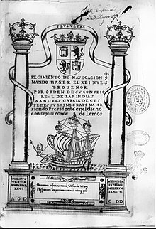
The Torres Strait, also known as Zenadh Kes, is a strait between Australia and the Melanesian island of New Guinea. It is 150 km (93 mi) wide at its narrowest extent. To the south is Cape York Peninsula, the northernmost extremity of the Australian mainland. To the north is the Western Province of Papua New Guinea. It is named after the Spanish navigator Luís Vaz de Torres, who sailed through the strait in 1606.

Pedro Fernandes de Queirós (1563–1614) was a Portuguese navigator in the service of Spain. He is best known for leading several Spanish voyages of discovery in the Pacific Ocean, in particular the 1595–1596 voyage of Álvaro de Mendaña y Neira, and for the 1605–1606 expedition that crossed the Pacific in search of Terra Australis.

Duyfken, also in the form Duifje or spelled Duifken or Duijfken, was a small ship built in the Dutch Republic. She was a fast, lightly armed ship probably intended for shallow water, small valuable cargoes, bringing messages, sending provisions, or privateering. The tonnage of Duyfken has been given as 25–30 lasten.
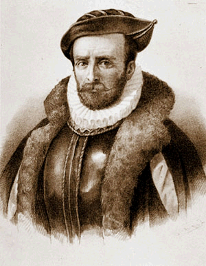
Willem Janszoon, sometimes abbreviated to Willem Jansz., was a Dutch navigator and colonial governor. Janszoon served in the Dutch East Indies in the periods 1603–1611 and 1612–1616, including as governor of Fort Henricus on the island of Solor. During his voyage of 1605–1606, he became the first European known to have seen and landed on the coast of Australia.

Willem Janszoon Blaeu, also abbreviated to Willem Jansz. Blaeu, was a Dutch cartographer, atlas maker, and publisher. Along with his son Johannes Blaeu, Willem is considered one of the notable figures of the Netherlandish or Dutch school of cartography during its golden age in the 16th and 17th centuries.
Álvaro de Mendaña y Neira was a Spanish navigator, explorer, and cartographer, best known for two of the earliest recorded expeditions across the Pacific Ocean in 1567 and 1595. His voyages led to the discovery of the Marquesas, Cook Islands, and Solomons among other archipelagos. Born in Congosto, in El Bierzo Region (León), he was the nephew of Lope García de Castro, viceroy of Peru.

Willem Janszoon captained the first recorded European landing on the Australian continent in 1606, sailing Duyfken from Bantam, Java. As an employee of the Dutch East India Company, Janszoon had been instructed to explore the coast of New Guinea in search of economic opportunities. He had originally arrived in the Dutch East Indies from the Netherlands in 1598, and became an officer of the VOC on its establishment in 1602.

Hessel Gerritsz was a Dutch engraver, cartographer, and publisher. He was one of the notable figures in the Golden Age of Netherlandish cartography. Despite strong competition, he is considered by some "unquestionably the chief Dutch cartographer of the 17th century".

Raroia, or Raro-nuku, is an atoll of the Tuamotus chain in French Polynesia, located 740 km northeast of Tahiti and 6 km southwest of Takume. Administratively it is a part of the commune of Makemo.
Luís Vaz de Torres, or Luis Váez de Torres in the Spanish spelling, was a 16th- and 17th-century maritime explorer and captain of a Spanish expedition noted for the first recorded European navigation of the strait that separates the Australian mainland from the island of New Guinea, and which now bears his name.
Early Polynesian explorers reached nearly all Pacific islands by 1200 CE, followed by Asian navigation in Southeast Asia and the West Pacific. During the Middle Ages, Muslim traders linked the Middle East and East Africa to the Asian Pacific coasts, reaching southern China and much of the Malay Archipelago. Direct European contact with the Pacific began in 1512, with the Portuguese encountering its western edges, soon followed by the Spanish arriving from the American coast.
Australasia on the Map is the history and heritage division of the Australasian Hydrographic Society. It seeks to enhance Australians’ knowledge, understanding and appreciation of the nation's early history, beginning in 1606 with the voyages of Willem Janszoon in the Duyfken and Luis Váez de Torres in Los Tres Reyes and San Pedro, and continuing to the present.

The Mauritius was an early 17th century Dutch wooden-hulled sailing ship, documented as being in service to the Dutch East India Company between 1618 and 1622.

The Willem River or Willem's River was named during the voyage of the Dutch East India Company ship Mauritius in 1618, under the command of Supercargo Willem Janszoon and captained by Lenaert Jacobszoon, and is one of the few features named on a nautical chart made in 1627.

The European exploration of Australia first began in February 1606, when Dutch navigator Willem Janszoon landed in Cape York Peninsula and on October that year when Spanish explorer Luís Vaz de Torres sailed through, and navigated, Torres Strait islands. Twenty-nine other Dutch navigators explored the western and southern coasts in the 17th century, and dubbed the continent New Holland. Most of the explorers of this period concluded that the apparent lack of water and fertile soil made the region unsuitable for colonisation.