1928 Atlantic hurricane season

Last updated
1928 Atlantic hurricane season
1928 Atlantic hurricane season summary map.png
Season summary map
Seasonal boundaries
First system formedAugust 3, 1928
Last system dissipatedOctober 15, 1928
Strongest storm
Name "Okeechobee"
  Maximum winds160 mph (260 km/h)
(1-minute sustained)
  Lowest pressure929 mbar (hPa; 27.43 inHg)
Seasonal statistics
Total depressions7
Total storms6
Hurricanes4
Major hurricanes
(Cat. 3+)
1
Total fatalities>4,289
Total damage> $102 million (1928 USD)
Related articles
Atlantic hurricane seasons
1926, 1927, 1928, 1929, 1930

The 1928 Atlantic hurricane season featured the Okeechobee hurricane, the second deadliest tropical cyclone in the history of the contiguous United States. Only seven tropical cyclones developed during the season. Of these seven tropical systems, six of them intensified into a tropical storm and four further strengthened into hurricanes. One hurricane deepened into a major hurricane, which is Category 3 or higher on the modern-day Saffir–Simpson hurricane wind scale. [1] The first system, the Fort Pierce hurricane, developed near the Lesser Antilles on August 3. The storm crossed the Bahamas and made landfall in Florida. Two fatalities and approximately $235,000 in damage was reported. [nb 1] A few days after the first storm developed, the Haiti hurricane, formed near the southern Windward Islands on August 7. The storm went on to strike Haiti, Cuba, and Florida. This storm left about $2 million in damage and at least 210 deaths. Impacts from the third system are unknown.

Contents

The most significant storm of the season was Hurricane Four, nicknamed the Okeechobee hurricane. Becoming a Category 5 hurricane, the hurricane struck Puerto Rico at that intensity. Several islands of the Greater and Lesser Antilles suffered "great destruction", especially Guadeloupe and Puerto Rico. The storm then crossed the Bahamas as a Category 4 hurricane, leaving deaths and severe damage on some islands. Also as a Category 4, the cyclone struck West Palm Beach, Florida, resulting in catastrophic wind damage. Inland flooding and storm surge resulted in Lake Okeechobee overflowing its banks, flooding nearby towns and leaving at least 2,500 deaths, making it the second deadliest hurricane in the United States after the 1900 Galveston hurricane. Overall, this storm caused at least $100 million in damage and 4,079 deaths. The three remaining systems did not impact land. Collectively, the storms of this season left over $102 million in damage and at least 4,289 fatalities.

The season's activity was reflected with an accumulated cyclone energy (ACE) rating of 83, [1] slightly above the 19211930 average of 76.6. [2] ACE is a metric used to express the energy used by a tropical cyclone during its lifetime. Therefore, a storm with a longer duration will have high values of ACE. It is only calculated at six-hour increments in which specific tropical and subtropical systems are either at or above sustained wind speeds of 39 mph (63 km/h), which is the threshold for tropical storm intensity. Thus, tropical depressions are not included here. [1]

Timeline

1928 Okeechobee hurricane1928 Haiti hurricane1928 Fort Pierce hurricaneSaffir–Simpson Hurricane Scale1928 Atlantic hurricane season

Systems

Hurricane One

Category 2 hurricane (SSHWS)
Hurricane One Analysis 8 Aug 1928.jpg   1928 Atlantic hurricane 1 track.png
DurationAugust 3 – August 10
Peak intensity105 mph (165 km/h) (1-min) 971  mbar  (hPa)

This storm developed from a tropical wave north of the Virgin Islands on August 3. [3] The system paralleled the Greater Antilles throughout much of its early existence. On August 6, the tropical storm strengthened to the equivalent of a Category 1 hurricane while positioned over the Bahamas. The hurricane continued to intensify, and after reaching Category 2 hurricane strength, peaked with sustained winds of 105 mph (169 km/h) on August 7. Shortly thereafter, the hurricane made landfall as a slightly weaker storm near Fort Pierce, Florida, at 07:00  UTC on August 8. Weakening as it moved across Florida over the course of the next day, the storm briefly moved over the Gulf of Mexico before recurving northwards. It made a second landfall on the Florida Panhandle on August 10 as a tropical storm. Once inland, the system continued to weaken, degenerating to tropical depression strength before transitioning into an extratropical storm later that day. The extratropical remnants progressed outwards into the Atlantic Ocean before dissipating on August 14. [4]

In its early developmental stages north of the Greater Antilles, the storm disrupted shipping routes through the Bahamas and generated rough seas offshore Cuba. [5] [6] At its first landfall on Fort Pierce, the hurricane caused property damage in several areas, particularly in coastal regions, where numerous homes were unroofed. [7] Central Florida's citrus crop was hampered by the strong winds and heavy rain. [3] Several of Florida's lakes, including Lake Okeechobee, rose past their banks, inundating coastal areas. [8] [9] Damage to infrastructure was less in inland regions than at the coast, though power outages caused a widespread loss of communication. [10] At the hurricane's second landfall, wind damage was relatively minor, though torrential rainfall, aided by orthographic lift, caused extensive flooding as far north as the Mid-Atlantic states. [11] Overall, the hurricane caused $235,000 in damages, primarily in Florida, and two deaths. [3]

Hurricane Two

Category 1 hurricane (SSHWS)
Hurricane Two Analysis 10 Aug 1928.jpg   1928 Atlantic hurricane 2 track.png
DurationAugust 7 – August 17
Peak intensity90 mph (150 km/h) (1-min) ≤998  mbar  (hPa)

A tropical wave developed into a tropical depression near Tobago on August 7. [3] The system then passed through the Windward Islands just south of Carriacou and Petite Martinique. Upon entering the Caribbean Sea early on August 8, the tropical depression strengthened into a tropical storm. On August 9, the storm strengthened to the equivalent of a Category 1 hurricane, while positioned south of Dominican Republic. The next day, the hurricane peaked with winds of 90 mph (140 km/h). After striking the Tiburon Peninsula of Haiti, the cyclone began weakening and fell to tropical storm intensity on August 12. By midday on the following day, the storm made landfall near Cienfuegos, Cuba. Upon emerging into the Straits of Florida, the storm began to re-strengthen. Early on August 13, it struck Big Pine Key, Florida, as a strong tropical storm. Weakening slowly while moving north-northwestward, the system made another landfall near St. George Island. After moving inland, the tropical storm slowly deteriorated, falling to tropical depression intensity on August 15 and dissipating over West Virginia on August 17. [4]

In Haiti, the storm completely wiped out livestock and many crops, particularly coffee, cocoa, and sugar. [12] Several villages were also destroyed, rendering approximately 10,000 people homeless. The damage totaled $1 million and at least 200 deaths were reported. [13] The only impact in Cuba was downed banana trees. [3] In Florida, the storm left minor wind damage along the coast. A Seaboard Air Line Railroad station was destroyed in Boca Grande, while signs, trees, and telephone poles were knocked down in Sarasota. Several streets in St. Petersburg were closed due to flooding or debris. [14] Between Cedar Key and the Florida Panhandle, several vessels capsized. Water washed up along the side of roads and in wooded areas. [15] The storm contributed to flooding onset by the previous hurricane, with rainfall peaking at 13.5 in (340 mm) in Caesars Head, South Carolina. [16] The worst impact from flooding occurred in North Carolina, where several houses were demolished. Six people were killed in the state, of which four due to flooding. Property damage in the state totaled over $1 million. [17] Overall, the storm caused at least $2 million in damage and 210 fatalities. [13] [17]

Tropical Storm Three

Tropical storm (SSHWS)
Tropical Storm Three Analysis 4 Sep 1928.jpg   1928 Atlantic tropical storm 3 track.png
DurationSeptember 1 – September 8
Peak intensity60 mph (95 km/h) (1-min) 

A tropical storm formed on September 1 just south of Hispaniola. Moving just north of due west, the system brushed the south coast of Jamaica as a 40 mph (64 km/h) tropical storm on September 2 before slowly beginning to intensify on September 3. The strengthening tropical storm reached its peak of 60 mph (97 km/h) on September 4 shortly before making landfall on the Yucatan Peninsula near Playa del Carmen near its peak intensity early on September 5. The system deteriorated after crossing the peninsula and entering the Bay of Campeche early on September 6 as a weak tropical storm. Later, the storm restrengthened slightly to winds of 50 mph (80 km/h) while nearing mainland Mexico on September 7. The tropical storm then weakened slightly shortly before making landfall north of Tampico early on September 8 as a weak 40 mph (64 km/h) tropical storm. After moving inland, the system weakened quickly to a depression and dissipated. [4] The storm brought 2.18 in (55 mm) of rain to Brownsville, Texas. [18]

Hurricane Four

Category 5 hurricane (SSHWS)
1928 Okeechobee Hurricane Analysis 13 Sep.jpg   1928 Okeechobee hurricane track.png
DurationSeptember 6 – September 18
Peak intensity160 mph (260 km/h) (1-min) ≤929  mbar  (hPa)

The Great Okeechobee Hurricane of 1928 or The Great Bahamas Hurricane of 1928 or Hurricane San Felipe II of 1928

This system developed as a tropical depression just offshore the west coast of Africa on September 6. The depression strengthened into a tropical storm later that day, shortly before passing south of the Cape Verde Islands. Further intensification was slow and halted by late on September 7. However, about 48 hours later, the storm resumed strengthening and became a Category 1 hurricane on the modern-day Saffir–Simpson hurricane wind scale. Still moving westward, the system reached Category 4 intensity before striking Guadeloupe on September 12. [4] There, the storm brought 1,200 deaths and extensive damage, including the destruction of approximately 85%–95% of banana crops, the severe damage dealt to 70%–80% of tree crops, and the roughly 40% of the sugar cane crops ruined. [3] [19] Martinique, [20] Montserrat, [21] and Nevis also reported damage and fatalities, [22] but the impacts at those locations were not nearly as severe as in Guadeloupe. [3]

Around midday on September 13, the storm strengthened into a Category 5 hurricane, based on the anemometer at San Juan observing sustained winds of 160 mph (260 km/h). The hurricane peaked with sustained winds at the intensity. About six hours later, the system made landfall in Puerto Rico; it was the only recorded tropical cyclone to strike the island as a Category 5. [4] Very strong winds resulted in severe damage in Puerto Rico. Throughout the island, 24,728 homes were destroyed and 192,444 were damaged, leaving over 500,000 people homeless. Heavy rainfall also led to extreme damage to vegetation and agriculture. On Puerto Rico alone, there were 312 deaths and about $50 million in damage. [23] After emerging into the Atlantic, the storm weakened slightly, falling to Category 4 intensity. It began crossing through the Bahamas on September 16. [4] Many buildings and houses were damaged or destroyed, especially on Bimini, Eleuthera, New Providence, and San Salvador Island. Nineteen deaths were reported, eighteen from a sloop disappearing and one due to drowning. [21]

Early on September 17, the storm made landfall near West Palm Beach, Florida, with winds of 145 mph (233 km/h). [4] In the city, more than 1,711 homes were destroyed. Elsewhere in Palm Beach County, impact was severest around Lake Okeechobee. The storm surge caused water to pour out of the southern edge of the lake, flooding hundreds of square miles as high as 20 feet (6.1 m) above ground. Numerous houses and buildings were swept away in the cities of Belle Glade, Canal Point, Chosen, Pahokee, and South Bay. At least 2,500 people drowned, while damage was estimated at $25 million. [24] While crossing Florida, the system weakened significantly, falling to Category 1 intensity late on September 17. It curved north-northeastward and briefly re-emerged into the Atlantic on September 18, but soon made another landfall near Edisto Island, South Carolina, with winds of 85 mph (137 km/h). Early on the following day, the system weakened to a tropical storm and became extratropical over North Carolina hours later. [4] Overall, the system caused $100 million in damage and at least 4,079 deaths. [3] [20] [21] [22] [23] [24]

Tropical Storm Five

Tropical storm (SSHWS)
Tropical Storm Five Analysis 10 Sep 1928.jpg   1928 Atlantic tropical storm 5 track.png
DurationSeptember 8 – September 10
Peak intensity70 mph (110 km/h) (1-min) ≤1015  mbar  (hPa)

A tropical storm developed about 835 mi (1,344 km) northeast of Barbados on September 8. The storm moved rapidly north-northwestward and slowly strengthened. Upon turning northward on September 10, [4] the system attained its peak intensity as a strong tropical storm with maximum sustained winds of 70 mph (110 km/h) and a high minimum barometric pressure of 1,015 mbar (30.0 inHg), both of which were measured by ships. [3] Shortly thereafter, it began losing tropical characteristics and transitioned into an extratropical cyclone later that day while located about 700 mi (1,100 km) south-southeast of Cape Race, Newfoundland and Labrador. [4] The extratropical remnants continued to move rapidly northeastward until being absorbed by an extratropical low pressure. [3]

Tropical Depression

A low pressure area previously associated with a frontal system developed into a tropical depression near Bermuda on September 22. The depression had sustained winds of 30 mph (48 km/h) and failed to strengthen further. It became extratropical on September 23. [3]

Hurricane Six

Category 1 hurricane (SSHWS)
Hurricane Six Analysis 14 October 1928.jpg   1928 Atlantic hurricane 6 track.png
DurationOctober 10 – October 15
Peak intensity90 mph (150 km/h) (1-min) ≤980  mbar  (hPa)

The final cyclone of the season developed about 740 mi (1,190 km) west-northwest of the easternmost islands of Cape Verde on October 10. Moving north-northwest, the system maintained intensity on October 11, before beginning to intensify more rapidly on October 12. Early the next day, it strengthened into a Category 1 hurricane and peaked with maximum sustained winds of 90 mph (140 km/h). After turning northeastward, the hurricane weakened to a tropical storm on October 14. Around 06:00 UTC on October 15, the cyclone transitioned into an extratropical cyclone while situated approximately 285 mi (459 km) northwest of Flores Island in the Azores. [4]

See also

Further reading

Notes

  1. All damage figures are in 1928 United States dollars, unless otherwise noted

Related Research Articles

<span class="mw-page-title-main">2004 Atlantic hurricane season</span> Hurricane season in the Atlantic Ocean

The 2004 Atlantic hurricane season was a very deadly, destructive, and extremely active Atlantic hurricane season, with over 3,200 deaths and more than $61 billion in damage. More than half of the 16 tropical cyclones brushed or struck the United States. Due to the development of a Modoki El Niño – a rare type of El Niño in which unfavorable conditions are produced over the eastern Pacific instead of the Atlantic basin due to warmer sea surface temperatures farther west along the equatorial Pacific – activity was above average. The season officially began on June 1 and ended on November 30, though the season's last storm, Otto, dissipated on December 3, extending the season beyond its traditional boundaries. The first storm, Alex, developed offshore of the Southeastern United States on July 31, one of the latest dates on record to see the formation of the first system in an Atlantic hurricane season. It brushed the Carolinas and the Mid-Atlantic, causing one death and $7.5 million (2004 USD) in damage. Several storms caused only minor damage, including tropical storms Bonnie, Earl, Hermine, and Matthew. In addition, hurricanes Danielle, Karl, and Lisa, Tropical Depression Ten, Subtropical Storm Nicole and Tropical Storm Otto had no effect on land while tropical cyclones. The season was the first to exceed 200 units in accumulated cyclone energy (ACE) since 1995, mostly from Hurricane Ivan, the storm produced the highest ACE. Ivan generated the second-highest ACE in the Atlantic, only behind 1899 San Ciriaco Hurricane.

<span class="mw-page-title-main">1959 Atlantic hurricane season</span> Hurricane season in the Atlantic Ocean

The 1959 Atlantic hurricane season had a then record-tying number of tropical cyclones – five – develop before August 1. The season was officially to begin on June 15, 1959 and last until November 15, 1959, the period of each year when most tropical cyclones form in the Atlantic basin, however in actuality the season began early when Tropical Storm Arlene formed on May 28. Tropical Storm Arlene struck Louisiana and brought minor flooding to the Gulf Coast of the United States. The next storm, Beulah, formed in the western Gulf of Mexico and brought negligible impact to Mexico and Texas. Later in June, an unnamed hurricane, nicknamed the Escuminac disaster, caused minor damage in Florida and devastated coastal Nova Scotia and New Brunswick, after becoming extratropical. Hurricane Cindy brought minor impact to The Carolinas. In late July, Hurricane Debra produced flooding in the state of Texas. Tropical Storm Edith in August and Hurricane Flora in September caused negligible impact on land.

<span class="mw-page-title-main">1961 Atlantic hurricane season</span> Hurricane season in the Atlantic Ocean

The 1961 Atlantic hurricane season was a hyperactive Atlantic hurricane season, with an accumulated cyclone energy (ACE) total of 189. The season, however, was an average one in terms of named storms. The season featured eight hurricanes and a well above average number of five major hurricanes. It was previously thought that the season had a record-tying seven major hurricanes, before the Atlantic hurricane reanalysis project downgraded two storms in 2019. Two Category 5 hurricanes were seen in 1961, making it one of only seven Atlantic hurricane seasons to feature multiple Category 5 hurricanes in one season. The season started on June 15, and ended on November 15. These dates conventionally delimit the period of each year when most tropical cyclones form in the Atlantic basin. The first system, an operationally unclassified tropical depression, formed offshore east Central Florida on June 10, but dissipated a few days later. Next, Hurricane Anna developed in the eastern Caribbean Sea near the Windward Islands on July 20. It brought minor damage to the islands, as well as wind and flood impacts to Central America after striking Belize as a hurricane. Anna caused one death and about $300,000 (1961 USD) in damage. Activity went dormant for nearly a month and a half, until Hurricane Betsy developed on September 2. Betsy peaked as a Category 4 hurricane, but remained at sea and caused no impact.

<span class="mw-page-title-main">1963 Atlantic hurricane season</span> Hurricane season in the Atlantic Ocean

The 1963 Atlantic hurricane season featured one of the deadliest tropical cyclones on record in the Atlantic basin: Hurricane Flora. The season officially began on June 15, and lasted until November 15. These dates conventionally delimit the period of each year when most tropical cyclones form in the Atlantic basin. It was a slightly below average season in terms of tropical storms, with a total of ten nameable storms. The first system, an unnamed tropical storm, developed over the Bahamas on June 1. In late July, Hurricane Arlene, developed between Cape Verde and the Lesser Antilles. The storm later impacted Bermuda, where strong winds resulted in about $300,000 (1963 USD) in damage. Other storms such as hurricanes Beulah and Debra, as well as an unnamed tropical storm, did not impact land. During the month of September, Tropical Storm Cindy caused wind damage and flooding in Texas, leaving three deaths and approximately $12.5 million in damage. Hurricane Edith passed through the Lesser Antilles and the eastern Greater Antilles, causing 10 deaths and about $43 million in damage, most of which occurred on Martinique.

<span class="mw-page-title-main">1964 Atlantic hurricane season</span> Hurricane season in the Atlantic Ocean

The 1964 Atlantic hurricane season featured the highest number of U.S.-landfalling hurricanes since 1933. The season officially began on June 15, and lasted until November 30. These dates conventionally delimit the period of each year when most tropical cyclones form in the Atlantic basin. The season was above average, with thirteen named storms, seven hurricanes, and five major hurricanes. The first system, an unnamed tropical storm, developed on June 2, almost two weeks before the official start of the season. Striking Florida on June 6, the storm brought localized flooding to portions of Cuba and the Southeastern United States, leaving about $1 million in damage. The next storm, also unnamed, developed near the end of July; it did not impact land.

<span class="mw-page-title-main">1966 Atlantic hurricane season</span> Hurricane season in the Atlantic Ocean

The 1966 Atlantic hurricane season saw the Weather Bureau office in Miami, Florida, be designated as the National Hurricane Center (NHC) and assume responsibility of tropical cyclone forecasting in the basin. The season officially began on June 1, and lasted until November 30. These dates conventionally delimit the period of each year when most tropical cyclones form in the Atlantic basin. It was an above-average season in terms of tropical storms, with a total of 15. The first system, Hurricane Alma, developed over eastern Nicaragua on June 4 and became the most recent major hurricane in the month of June. Alma brought severe flooding to Honduras and later to Cuba, but caused relatively minor impact in the Southeastern United States. Alma resulted in 91 deaths and about $210.1 million (1966 USD) in damage.

<span class="mw-page-title-main">1975 Atlantic hurricane season</span> Hurricane season in the Atlantic Ocean

The 1975 Atlantic hurricane season featured the first tropical storm to be upgraded to a hurricane based solely on satellite imagery – Hurricane Doris. The season officially began on June 1 and lasted until November 30. These dates conventionally delimit the period of each year when most tropical cyclones form in the Atlantic basin. The season was near average, with nine tropical storms forming, of which six became hurricanes. Three of those six became major hurricanes, which are Category 3 or higher on the Saffir–Simpson scale. The first system, Tropical Depression One, developed on June 24. Tropical Storm Amy in July caused minor beach erosion and coastal flooding from North Carolina to New Jersey, and killed one person when a ship capsized offshore North Carolina. Hurricane Blanche brought strong winds to portions of Atlantic Canada, leaving about $6.2 million (1975 USD) in damage. Hurricane Caroline brought high tides and flooding to northeastern Mexico and Texas, with two drownings in the latter.

<span class="mw-page-title-main">1949 Atlantic hurricane season</span> Hurricane season in the Atlantic Ocean

The 1949 Atlantic hurricane season was the last season that tropical cyclones were not publicly labeled by the United States Weather Bureau. It officially began on June 15, and lasted until November 15. These dates conventionally delimit the period of each year when most tropical cyclones form in the Atlantic basin. The first storm, a tropical depression, developed in the northern Gulf of Mexico on August 14. The final system, Tropical Storm Sixteen, dissipated in the southwestern Caribbean Sea on November 5. It was a fairly active season, featuring 16 tropical storms and seven hurricanes. Two of these strengthened into major hurricanes, which are Category 3 or higher on the Saffir–Simpson hurricane wind scale.

<span class="mw-page-title-main">1946 Atlantic hurricane season</span> Hurricane season in the Atlantic Ocean

The 1946 Atlantic hurricane season resulted in no fatalities in the United States. The season officially began on June 15, 1946, and lasted until November 15, 1946. These dates conventionally delimit the period of each year when most tropical cyclones form in the Atlantic basin. However, the first storm, developed in the Gulf of Mexico on June 13, while the final system dissipated just offshore Florida on November 3. There were seven tropical storm; three of them attained hurricane status, while none intensified into major hurricanes, which are Category 3 or higher on the modern-day Saffir–Simpson hurricane wind scale. This had not occurred since 1940 and would not again until 1968. Operationally, the fifth tropical storm, which existed near the Azores in early October, was not considered a tropical cyclone, but was added to HURDAT in 2014.

<span class="mw-page-title-main">1935 Atlantic hurricane season</span> Hurricane season in the Atlantic Ocean

The 1935 Atlantic hurricane season included the Labor Day hurricane, the most intense tropical cyclone to ever strike the United States or any landmass in the Atlantic basin. The season ran from June 1 through November 15, 1935. Ten tropical cyclones developed, eight of which intensified into tropical storms. Five of the tropical storms strengthened into hurricanes, while three of those reached major hurricane intensity. The season was near-normal for activity and featured five notable systems. The second storm of the season sank many ships and vessels offshore Newfoundland, causing 50 fatalities. In early September, the Labor Day hurricane struck Florida twice – the first time as a Category 5 hurricane – resulting in about 490 deaths and $100 million (1935 USD) in damage along its path.

<span class="mw-page-title-main">1932 Atlantic hurricane season</span> Hurricane season in the Atlantic Ocean

The 1932 Atlantic hurricane season featured several powerful storms, including the Cuba hurricane, which remains the deadliest tropical cyclone in the history of Cuba and among the most intense to strike the island nation. It was a relatively active season, with fifteen known storms, six hurricanes, and four major hurricanes. However, tropical cyclones that did not approach populated areas or shipping lanes, especially if they were relatively weak and of short duration, may have remained undetected. Because technologies such as satellite monitoring were not available until the 1960s, historical data on tropical cyclones from this period are often not reliable. The Atlantic hurricane reanalysis project discovered four new tropical cyclones, all of which were tropical storms, that occurred during the year. Two storms attained Category 5 intensity, the first known occurrence in which multiple Category 5 hurricanes formed in the same year. The season's first cyclone developed on May 5, while the last remaining system transitioned into an extratropical cyclone by November 13.

<span class="mw-page-title-main">1921 Atlantic hurricane season</span> Hurricane season in the Atlantic Ocean

The 1921 Atlantic hurricane season featured the most recent major hurricane to strike the Tampa Bay area in Florida. Although no "hurricane season" was defined at the time, the present-day delineation of such is June 1 to November 30. The first system, a tropical depression, developed on June 1, while the last, a tropical storm, dissipated on November 25. Of note, three of the twelve cyclones co-existed with another tropical cyclone during the season.

<span class="mw-page-title-main">1918 Atlantic hurricane season</span> Hurricane season in the Atlantic Ocean

The 1918 Atlantic hurricane season featured two hurricane landfalls in the United States. The season was inactive, with a total of six tropical storms developing, four of which intensified into hurricanes. One of the four hurricanes became a major hurricane, which is Category 3 or higher on the modern-day Saffir–Simpson scale. Additionally, there were four suspected tropical depressions, including one that began the season on June 19 and one that ended the season when it dissipated on October 19. The early 20th century lacked modern forecasting and documentation, and thus, the hurricane database from these years may be incomplete. Four previously unknown tropical cyclones were identified using records, including historical weather maps and ship reports, while information on the known storms was amended.

<span class="mw-page-title-main">1912 Atlantic hurricane season</span> Hurricane season in the Atlantic Ocean

The 1912 Atlantic hurricane season featured the first recorded major hurricane – Category 3 or higher on the modern day Saffir–Simpson scale – in the month of November. There were eleven tropical cyclones, seven of which became tropical storms; four of those strengthened into hurricanes, and one reached major hurricane intensity. The season's first cyclone developed on April 4, while the final dissipated on November 21. The season's most intense and most devastating tropical cyclone was the final storm, known as the Jamaica hurricane. It produced heavy rainfall on Jamaica, leading to at least 100 fatalities and about $1.5 million (1912 USD) in damage. The storm was also blamed for five deaths in Cuba.

<span class="mw-page-title-main">1909 Atlantic hurricane season</span> Hurricane season in the Atlantic Ocean

The 1909 Atlantic hurricane season was an average Atlantic hurricane season. The season produced thirteen tropical cyclones, twelve of which became tropical storms; six became hurricanes, and four of those strengthened into major hurricanes. The season's first storm developed on June 15 while the last storm transitioned into an extratropical cyclone on November 14. The most notable storm during the season formed in late August, while east of the Lesser Antilles. The hurricane devastated the Lesser Antilles, the Greater Antilles, and Mexico, leaving around 4,000 fatalities and more than $50 million (1909 USD) in damage.

<span class="mw-page-title-main">1901 Atlantic hurricane season</span> Hurricane season in the Atlantic Ocean

The 1901 Atlantic hurricane season was the most active season without a major hurricane – tropical cyclones that reach at least Category 3 on the Saffir–Simpson hurricane wind scale – until 2013. The first system was initially observed in the northeastern Caribbean on June 11. The fourteenth and final system transitioned into an extratropical cyclone near Bermuda on November 5. These dates fall within the period with the most tropical cyclone activity in the Atlantic. Eight of the fourteen tropical cyclones existed simultaneously.

<span class="mw-page-title-main">1900 Atlantic hurricane season</span> Hurricane season in the Atlantic Ocean

The 1900 Atlantic hurricane season featured the Galveston hurricane, the deadliest natural disaster in the history of the United States. A total of 10 tropical cyclones formed, seven of which intensified into a tropical storm. Three of those made landfall in the United States. The first system was initially observed over the central Atlantic Ocean on January 17, while the final storm transitioned into an extratropical cyclone on October 28. These dates fall within the period with the most tropical cyclone activity in the Atlantic. Every storm of the season except the seventh system existed simultaneously with another tropical cyclone.

<span class="mw-page-title-main">1899 Atlantic hurricane season</span> Hurricane season in the Atlantic Ocean

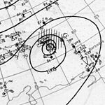
The 1899 Atlantic hurricane season featured the longest-lasting tropical cyclone in the Atlantic basin on record. There were nine tropical storms, of which five became hurricanes. Two of those strengthened into major hurricanes, which are Category 3 or higher on the modern day Saffir–Simpson hurricane wind scale. The first system was initially observed in the northeastern Gulf of Mexico on June 26. The tenth and final system dissipated near Bermuda on November 10. These dates fall within the period with the most tropical cyclone activity in the Atlantic. In post-season analysis, two tropical cyclones that existed in October were added to HURDAT – the official Atlantic hurricane database. At one point during the season, September 3 through the following day, a set of three tropical cyclones existed simultaneously.

<span class="mw-page-title-main">1878 Atlantic hurricane season</span> Hurricane season in the Atlantic Ocean

The 1878 Atlantic hurricane season lasted from the summer through much of the fall. Records show that 1878 featured a relatively active hurricane season. A total of twelve storms were observed during the year. There were twelve tropical storms, eight hurricanes and two major hurricanes. However, in the absence of modern satellite and other remote-sensing technologies, only storms that affected populated land areas or encountered ships at sea were recorded, so the actual total could be higher. An undercount bias of zero to six tropical cyclones per year between 1851 and 1885 and zero to four per year between 1886 and 1910 has been estimated. Of the known 1878 cyclones, both Hurricane Three and Hurricane Four were first documented in 1995 by Jose Fernandez-Partagas and Henry Diaz, who also proposed large changes to the known tracks of Hurricanes Two, Seven and Eight. Further analysis from 2000 onwards extended the duration of Hurricane Three by one day and identified major track changes for Hurricane Five.

<span class="mw-page-title-main">2020 Atlantic hurricane season</span> Hurricane season in the Atlantic Ocean

The 2020 Atlantic hurricane season featured a total of 31 tropical or subtropical cyclones, making it the most active Atlantic hurricane season on record. All but one cyclone became a named storm. Of the 30 named storms, 14 developed into hurricanes, and a record-tying seven further intensified into major hurricanes. It was the second and final season to use the Greek letter storm naming system, the first being 2005, the previous record. Of the 30 named storms, 11 of them made landfall in the contiguous United States, breaking the record of nine set in 1916. During the season, 27 tropical storms established a new record for earliest formation date by storm number. This season also featured a record 10 tropical cyclones that underwent rapid intensification, tying it with 1995, as well as holding the record for most Category 4 hurricanes in a singular season in the Atlantic Basin. This unprecedented activity was fueled by a La Niña that developed in the summer months of 2020 as it did, continue a stretch of above-average seasonal activity that began in 2016. Despite the record-high activity, this was the first season since 2015 in which no Category 5 hurricane formed.

References

  1. 1 2 3 Atlantic basin Comparison of Original and Revised HURDAT. Hurricane Research Division; Atlantic Oceanographic and Meteorological Laboratory (Report). Miami, Florida: National Oceanic and Atmospheric Administration. June 2019. Retrieved August 23, 2021.
  2. Christopher W. Landsea; et al. (February 1, 2012). "A Reanalysis of the 1921–30 Atlantic Hurricane Database" (PDF). Journal of Climate. Miami, Florida: National Oceanic and Atmospheric Administration. 25 (3): 869. Bibcode:2012JCli...25..865L. doi: 10.1175/JCLI-D-11-00026.1 . Retrieved September 6, 2021.
  3. 1 2 3 4 5 6 7 8 9 10 11 Christopher W. Landsea; et al. (December 2012). Documentation of Atlantic Tropical Cyclones Changes in HURDAT. Atlantic Oceanographic and Meteorological Laboratory (Report). Miami, Florida: National Oceanic and Atmospheric Administration. Retrieved June 6, 2015.
  4. 1 2 3 4 5 6 7 8 9 10 11 "Atlantic hurricane best track (HURDAT version 2)" (Database). United States National Hurricane Center. September 19, 2022. Retrieved March 25, 2023.PD-icon.svg This article incorporates text from this source, which is in the public domain .
  5. "Storm Curves Away; Florida to Miss Blow". Sarasota Herald-Tribune. Miami, Florida. Associated Press. August 6, 1928. p. 1. Retrieved March 21, 2013.
  6. "Heavy Sea on Cuban Coast". The Evening Independent. Havana, Cuba. Associated Press. August 8, 1928. p. 12. Retrieved March 22, 2013.
  7. "Tampa Isolated by Florida Storm". Painesville Telegraph. Jacksonville, Florida. Associated Press. August 9, 1928. p. 1. Retrieved March 23, 2013.
  8. "Hurricane Sweeps to Gulf". Rochester Evening Journal and the Post Express. Jacksonville, Florida. Associated Press. August 9, 1928. p. 2. Retrieved March 22, 2013.
  9. "Florida in Grip of Gale". Lewiston Evening Journal. Melbourne, Florida. Associated Press. August 8, 1928. p. 9. Retrieved March 22, 2013.
  10. "Roofs Off at Kissimmee". The Evening Independent. Tampa, Florida. Associated Press. August 9, 1928. p. 1. Retrieved March 23, 2013.
  11. R. W. Schoner; S. Molansky. "Rainfall Associated With Hurricanes (And Other Tropical Disturbances)" (PDF). United States Weather Bureau's National Hurricane Research Project. p. 84. Retrieved March 21, 2013.
  12. "Haiti Hurricane". The Observer . New York. September 8, 1928. p. 56. Retrieved September 4, 2015.
  13. 1 2 "Haiti Hurricane Leaves Death, Chaos In Wake". Chicago Tribune . Port-au-Prince, Haiti. Associated Press. August 19, 1928. p. 3. Retrieved September 4, 2015.
  14. "Pass-a-Grille Warned Against High Tides Today Following Tropical Gale Which Swept Entire West Coast but Caused Little Damage". St. Petersburg Times . August 14, 1928. pp. 1–2. Retrieved September 4, 2015.
  15. "Boats Wrecked, Hodges Reports". St. Petersburg Times. Tallahassee, Florida. Associated Press. August 16, 1928. p. 2. Retrieved September 4, 2015.
  16. United States Army Corps of Engineers (1945). Storm Total Rainfall In The United States. War Department. p. SA 2–13.
  17. 1 2 "Ten Die in Tropical Storm that Hits Southern States". Huntingdon Daily News. August 17, 1928.
  18. "Tropical Storm Passed Inland on Coast of Mexico". Corsicana Daily Sun . Brownsville, Texas. September 8, 1928. p. 1. Retrieved August 27, 2021 via Newspapers.com. Lock-green.svg
  19. Don R. Hoy (1961). Agricultural Land Use of Guadeloupe, Issue 12. Washington, D.C.: National Academies Press. p. 64. Retrieved March 15, 2014.
  20. 1 2 Edward N. Rappaport; Jose Fernandez-Partagas; Jack Beven (1995–1997). The Deadliest Atlantic Tropical Cyclones, 1492–1996. National Hurricane Center (Report). National Oceanic and Atmospheric Administration.
  21. 1 2 3 Wayne Neely (2014). The Great Okeechobee Hurricane of 1928. Bloomington, Indiana: iUniverse. ISBN   978-1-4917-5446-7 . Retrieved May 7, 2015.
  22. 1 2 Vincent K. Hubbard (2002). Swords, Ships & Sugar: History of Nevis. Corvallis, Oregon: Premiere Editions International.
  23. 1 2 Frank Mújica-Baker. Huracanes y Tormentas que han afectado a Puerto Rico (PDF) (in Spanish). Estado Libre Asociado de Puerto Rico, Agencia Estatal para el manejo de Emergencias y Administración de Desastres. pp. 4, 9, 10. Archived from the original (PDF) on September 24, 2015. Retrieved September 5, 2015.
  24. 1 2 Memorial Web Page for the 1928 Okeechobee hurricane. National Weather Service Miami, Florida (Report). Miami, Florida: National Oceanic and Atmospheric Administration. June 29, 2009. Retrieved August 27, 2021.