Central Florida is a region of the U.S. state of Florida. Different sources give different definitions for the region, but as its name implies it is usually said to comprise the central part of the state, including the Tampa Bay area and the Greater Orlando area, though in recent times the Tampa Bay area has often been described as its own region, with "Central Florida" becoming more synonymous with the Orlando area (most notably, this is what the local news channels in each respective metro area call their region).[1][2]
Between July 1, 2023 and July 1, 2024, the Orlando metropolitan statistical area, which lies in Central Florida, grew by 2.7%, adding about 75,969 new residents. This made it the fastest-growing large metro region in the United States by percentage during that year.[3]
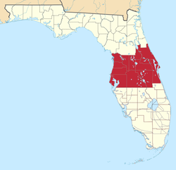
Like many vernacular regions, Central Florida's boundaries are not official or consistent, and are defined differently by different sources. A 2007 study of Florida's regions by geographers Ary Lamme and Raymond K. Oldakowski found that Floridians surveyed identified Central Florida as comprising a large swath of peninsular Florida.[4] This area encompassed the interior, including the Orlando metropolitan area, and coastal stretches from the Citrus County south to the Hillsborough County in the west and from Volusia County south to Sebastian in the east.
Central Florida is one of Florida's three most common directional regions, the others being North Florida and South Florida. Lamme and Oldakowski note that the directional region is more commonly used in the interior areas rather than on the coast.[5] In fact, while coastal areas often have their own regional vernacular identities such as the Space Coast and the Nature Coast, no vernacular regions were reported on the interior of the state other than Central Florida.[4]
Enterprise Florida, the state's economic development agency, identifies "Central Florida" as one of eight economic regions used by the agency and other state and outside entities, including the Florida Department of Transportation. This definition covers much of the same area as in Lamme and Oldakowski's survey, with some exceptions. The central region includes the Orlando metropolitan area (Orange, Lake, Osceola, and Seminole Counties), and Sumter, Polk counties in the interior, Citrus, Hernando, Hillsborough, Pasco, and Pinellas counties on the west coast and Volusia and Brevard Counties on the east coast.[6]
The central cities of both metropolitan areas (Orlando and Tampa) are in close proximity (85 miles (137km)), and as a result, their two metropolitan areas blend together in the area of Lakeland to make up a larger contiguous population center often referred to as the I-4 corridor.[7][8] This is a population concentration that stretches from Tampa Bay on the west coast to Daytona Beach and Cape Canaveral on the east coast of the state.
With the exception of hill terrain in Mount Dora, southern Lake County, Polk County (Lake Wales Ridge) Pasco County, and Hernando County (Brooksville Ridge). Central Florida is mostly flatland with significant amounts of open space and over 1,500 lakes and ponds. There is a mixture of wetlands, Cypress, Oak, Maple and Pine forests, pastures, prairies and coastline.[9]
Historic Cypress Gardens, (now Lego-Land) in central Florida.
Winters are dry and temperate with the average winter high temperature in Orlando being 71°F (22°C) and the average winter low temperature being 49°F (9°C).[11][12] Summers are hot and humid with high temperatures averaging 92°F (33°C) and low temperatures averaging 75°F (24°C). Peak summer heat generally arrives in early June and continues to early October.[13][14]
The combination of high temperatures, high humidity, and opposing sea breezes from both the Gulf and Atlantic coasts, results in significant thunderstorm activity from June to September for the interior counties. Central Florida records more lightning strikes per area than any other region in Florida, and Florida records more lightning strikes than any other state in the US. As a result, Florida, and more specifically, Central Florida, is often referred to as the "Thunderstorm capital of the USA",[15][16] or "Lightning Alley."[17]
These severe thunderstorms often make Central Florida prone to many tornadoes. However, they are usually small, short lived, and almost always rated as EF0 or EF1 size storms.
According to the Köppen climate classification, Central Florida has a subtropical climate. A climate that is typical for the majority of the state, except for South Florida, which has a tropical climate. Unlike South Florida, where temperatures below 32°F (0°C) practically never occur, Central Florida can see occasional freezing temperatures in the some winters (though brief). Consequently, most of Central Florida cannot accommodate the same tropical plants found in Southern Florida with the exception of coastal areas in the Tampa Bay area, Brevard county, and Indian River county due to maritime influences of the Gulf of Mexico and Atlantic Ocean.[18] However, winters are still warmer than most other areas of the United States in winter. Central Florida’s typical high temperatures in the winter are around 70°F (21°C). The low temperatures near 50 F.
Climate data for Orlando (Orlando International Airport), Florida (1991-2020 normals, extremes 1952–present)
The Yearling won Floridian Marjorie Kinnan Rawlings a Pulitzer Prize for her glimpse at life in central Florida.
At the end of the Civil War, aside from the cattle, cotton, and coastal lands, much of Central Florida was wetlands. It took a major drainage project financed by businessman Hamilton Disston in the 1880s to make these wetland areas available for settlement.
Sanford was incorporated in 1877 as a port city at the Lake Monroe intersection and the St. Johns River. It was envisioned as a transportation center; the city's founder, Henry S. Sanford, nicknamed it "the Gate City of South Florida". It became a hub for shipping agricultural products, which earned the city another nickname, "Celery City".
Kissimmee, originally named Allendale, after Confederate Major J.H. Allen, who operated the first cargo steamboat on the Kissimmee River, boomed in the 1880s. It was the headquarters of Hamilton Disston's drainage company. The city was an important regional steamship port, owing that status to its location on Lake Tohopekaliga. Expanding the railroads into Central Florida eliminated the need for Kissimmee's steamship industry.[21]
The Great Freeze of 1894-1895 ruined citrus crops, which had a detrimental ripple effect on the economy.[22]
The hard-packed sand of Volusia County's beaches lent itself to auto races beginning in 1903 before paved roads were common, leading to the area's reputation for cars and racing.[23] Ormond Beach was a popular spot for those who liked fast cars after the turn of the 20th century because the hard-packed beach was ideal for going fast. The same beach had led to the development of a tourist resort by Henry Flagler. It later attracted Flagler's former business partner John D. Rockefeller, who had a winter home in Ormond.
During and after World War II, the U.S. Army Air Forces (U.S. Air Force after 1947) and the U.S. Navy established several training facilities and operational bases in the region, mainly for aviation activities, followed by space exploration sites. In the late 1940s, the U.S. military established a missile testing facility on Merritt Island near Cape Canaveral. The land was largely undeveloped and the agreeable climate allowed for year-round operations. When NASA later searched for a long-term base in the 1960s to launch spacecraft, it chose the Merritt Island site next to Cape Canaveral for its access to the testing facility and nearby communities. NASA purchased over 100,000 acres (400km2) of land for the Kennedy Space Center.
Deltona was developed in 1962 as a planned retirement community. It is now the largest city in Volusia County.
Yulee Sugar Mill, located in the Central Florida town of Homosassa. The Florida State Park is the site of David Levy Yulee's 5,100-acre sugar plantation. The mill operated from 1851 to 1864 and served as a supplier of sugar products for Southern troops during the Civil War.Spanish Moss by Winslow Homer, Tampa Bay, a painting of Spanish Moss swaying from live oak limbs, a familiar scene in central Florida
The construction of the Walt Disney World Resort was a transforming event for greater Orlando. Walt Disney wanted a location with abundant available land that was more accessible for the residents of the eastern United States to visit. Not only was there ample land in Central Florida, but it was inexpensive, and the inland location offered some protection from hurricanes. Plans were announced in 1965, and the theme park opened to the public in 1971.[21]
Culture and attributes
Lamme and Oldakowski's survey identifies several demographic, political, and cultural elements that characterize Central Florida and distinguish it from other areas of the state. While people from all parts of the state associated their area as part of the South, people in the southern part of Central Florida did not typically identify their area as part of "Dixie", while people in northern Central Florida did. People from Central Florida usually did not consider their region part of the Bible Belt.[4]
Politically, while North Florida overwhelmingly was considered conservative and South Florida was considered more liberal, the majority of Central Florida residents (52%) considered their area moderate; 41% considered it conservative, and 7% liberal.[24] Lamme and Oldakowski's survey tracks with Barney Warf and Cynthia Waddell's studies of Florida's political geography during the 2000 Presidential election.[24][25] Central Florida's economy is very similar to that in South Florida. Compared to the more diversified North Florida economy, tourism is by far the most significant industry in Central and South Florida, along with a much smaller but significant agricultural industry.[26]
Central Florida cowboy culture, Silver Spurs Rodeo, Kissimmee
Lamme and Oldakowski's survey also found some cultural indicators that characterize Central Florida. In general, Central Florida was similar to North Florida and differed from South Florida in these measures. In Central and North Florida, American cuisine was the most popular food, in contrast to South Florida where ethnic foods were equally popular.[27] Additionally, while there was little geographical variation for most styles of music, there was regional variation for both country and Latin music. Country was popular in Central and North Florida, and less so in South Florida, while Latin was less popular in Central and North Florida, and more so in South Florida.[27]
Demographics
In 2009, the estimated total population of the Central Florida, including the populations of Orange, Seminole, Osceola, Brevard, Volusia, and Lake Counties region was 3.3 million people.[28] If the populations of Polk and Sumter counties were included, the estimated population would be 3.969 million people.[citation needed] Exponential growth has fueled Central Florida for the past thirty years. The U.S. Census Bureau reported that the Orlando–Kissimmee–Sanford metropolitan area ranked among the fastest-growing metros in the country during 2022 and 2023. This expansion aligns with a broader statewide trend in Florida, which has seen consistent population surges fueled by domestic migration, favorable business conditions, and infrastructure development (U.S. Census Bureau, 2024).[29] In 2024, Orlando’s 2.7% population growth surpassed Florida’s overall statewide growth rate of 2.0%. This indicates that Central Florida is expanding faster than nearly all other regions of the state, reinforcing its economic and cultural significance within Florida (ClickOrlando, 2025).[30]
As of 2007 there were 70,000 Asians in Central Florida according to the U.S. Census. There were almost 1,900 Japanese persons, making up 3% of the Asians.[31]
Recent Growth (2024)
During July 1, 2023, and July 1, 2024, the Orlando metropolitan statistical area—representing the core of Central Florida—experienced a population increase of approximately 2.7%, adding nearly 75,969 residents. This growth made it the largest percentage increase among major U.S. metropolitan areas that year, highlighting the region’s strong migration and housing trends (Hamilton, 2025).[32]
Cities
Selected cities in Central Florida arranged by population:
Agriculture has occupied a large portion of Central Florida's economy, with winter strawberries,[35] citrus, timber, vegetables,[36] and aquaculture[37] all making major contributions.
Orange groves, central Florida
Tourism is a large contributor to Central Florida's economy.
The Tampa Bay area has become a center of high-tech manufacturing and research,[40][41] while both Orlando and the Tampa Bay area are centers for the financial industry, especially insurers and back-end operations for large banking companies.
Ferris Groves Store in Floral City, one of many Old Florida style citrus stands found on the back roads of central Florida.Plant City Strawberry Festival, Congressman Putnam with wife Melissa and their daughters at the Strawberry Parade in Plant City, Florida,
The other major U.S. Government installations in Central Florida is the Kennedy Space Center, a NASA facility located adjacent to Cape Canaveral SFS, and the Department of Veterans Affairs (VA) Outpatient Clinic at Baldwin Park (former Orlando AFB Hospital / former Naval Hospital Orlando) and the VA Hospital at Lake Nona.
Triple Crown Growth
According to the Orlando Economic Partnership, Central Florida recently earned a “Triple Crown” distinction by simultaneously leading the United States in job growth, population growth, and gross domestic product (GDP) expansion. This achievement reflects the area’s thriving tourism, technology, and business service industries that continue to attract new companies and residents (Orlando Economic Partnership, n.d.).[42]
Attractions
Cracker Country Living History Museum, located at The Florida State Fairgrounds, Tampa, founded by Mr. and Mrs. Doyle Carlton Jr. to ensure future generations might better understand and appreciate Florida's rural heritageDaytona International Speedway on the day of the Daytona 500 in central Florida
The central Florida seafood industry is shown here with a photograph of shrimp, snapper, grouper, and stone crab fishing boats at Cortez, Florida.
Port Canaveral, located in Cape Canaveral 45 minutes east of Orlando, is a cruise, cargo, and naval port. It is one of the busiest ports in Florida and is economically tied to Orlando. Locally perceived to be Orlando's seaport, Port Canaveral is the closest port for tourists and Orlando residents alike to cruise on Disney Cruise Lines and Carnival Cruises. Future plans for the port include a rail and natural gas line running directly to Orlando International Airport.
Another major seaport of the region is Port Tampa Bay, which is one of the busiest in the state and is on the verge of a huge expansion which will allow it to compete on an international level.
The Dixie Highway is a historic route passing through the heart of central Florida. Before the interstate system, it connected motorists traveling to towns such as Orlando, Arcadia and Bartow.
A regional commuter rail network is being developed in Central Florida. The first of these initiatives, SunRail, is a commuter rail line that runs from DeLand south to Kissimmee. The first phase was completed in 2014 with the full system in place in 2015. Amtrak also serves Central Florida running on CSX Transportation's A line and stops at the Orlando Amtrak station. The Auto Train stops in Sanford, Florida, north of downtown Orlando.
As of 2022, a high speed rail between Orlando and Miami is currently being developed by Brightline, who plans to extend the rail to Tampa after completion.[44]
Central Florida is also recognized as a hub for innovation, anchored by the Central Florida Research Park located near the University of Central Florida. The park is the largest research complex in the state, hosting more than 120 defense, simulation, and high-tech companies that contribute to national research, modeling, and training initiatives (Central Florida Research Park, n.d.).[45]
↑ Tomlinson, Philip Barry (1980). The Biology of Trees Native to Tropical Florida. Allston, Massachusetts U.S.A.: Harvard University Printing Office. pp.1, 8–10. C.S. Sargent designated ...major "tree regions" of [North America] ...each distinguished by a complex of tree species... [The] smallest of these ...called "Tropical Florida" ...[in which] 87.5% have an otherwise tropical distribution; in Florida they are at [their] northern limit. ...The distribution of tropical tree species within south Florida is not known in any detail although the generalized distribution of all species is well summarized by Little (1978). A single latitudinal line does not separate the foras of south and central Florida... Since the factor limiting the distribution of tropical species in a northern direction is almost certainly minimum winter temperature, an approximate indication of the limits... is the 54-degF January isotherm for the state. Figure 5
Lamme, Ary J.; Oldakowski, Raymond K. (November 2007). "Spinning a new geography of vernacular regional identity: Florida in the twenty-first century". Southeastern Geographer. 47 (2): 320–340. doi:10.1353/sgo.2007.0029. S2CID129577530.
Warf, Barney; Waddell, Cynthia (January 2002). "Florida in the 2000 presidential election: historical precedents and contemporary landscapes". Political Geography. 21 (1): 85–90. doi:10.1016/S0962-6298(01)00063-4.
This page is based on this Wikipedia article Text is available under the CC BY-SA 4.0 license; additional terms may apply. Images, videos and audio are available under their respective licenses.