1936 Northeastern United States flood

Last updated

In Holyoke, Massachusetts, the Connecticut River overflowed its banks as a result of the flood. Connecticut River Overflowing Holyoke Dam during the Flood of 1936, view south from Hadley Falls, March 1936.jpg
In Holyoke, Massachusetts, the Connecticut River overflowed its banks as a result of the flood.

The 1936 Northeastern United States flood was a historic flood that occurred across the Northeastern United States, as well as the Mid-Atlantic region and Ohio, in March 1936. Record-setting flooding after a combination of a particularly precipitation-heavy winter and large amounts of rainfall in March caused severe damage across the region. [1]

Contents

Record heights were recorded in many rivers, including the Connecticut River, which peaked at 37.6 feet (11.5 m) in Hartford, the Merrimack River, the Pemigewasset River, and the Androscoggin River. [1]

The flood led to an estimated 150 to 200 deaths across the Northeast, and hundreds of millions of dollars in damage in 1936 dollars. [2] :2 $100 million in 1936 dollars is equivalent in purchasing power to about $2.2 billion dollars in 2023. [3]

Background

The winter of 1935–36 was particularly cold, and more snowfall than usual fell in the Northeast. [4] When March arrived, along with warmer temperatures, this snow began to melt, causing water levels in rivers to rise. This was aggravated by several precipitation-heavy storm systems, which hit the region back to back in early to mid March. The first of these storm systems hit the region starting on March 9, associated with a warm front which stalled over the area. Significant amounts of rain fell, with amounts as high as 5 inches (130 mm) reported in Northern New England. [1] A second storm system arrived around March 18, which produced even more rain than the previous one. Pinkham Notch in New Hampshire recorded 10 inches (250 mm) of rain between March 18 and 19. [1]

In its report on the flooding, the United States Geological Survey described March 1936 in no uncertain terms: "The depths of rainfall mark this period as one of the greatest concentrations of precipitation, in respect to time and magnitude of the area covered, of which there is record in this country." [2] :1

First flood

Starting on March 12, flooding was observed across the Northeast, from Maine to Pennsylvania. [5] [6] Significant damage was caused by ice jams on numerous rivers, including the Hudson River. Twenty people were confirmed dead from flooding on March 13. [7] The flooding was somewhat arrested by a freeze starting on March 13. [7]

Massachusetts

The Holyoke Dam had a 5,000-square-foot (460 m2) section ripped out by an ice jam. [1]

Connecticut

In what was hailed as the "worst Connecticut floods in years", major damage occurred to transportation links, industries, and homes alike. The New Haven Railroad and Central Vermont Railway both reported numerous washouts along their tracks, while houses were carried away along the flooded Housatonic River in the western part of the state. [6] Across the state, evacuations were ordered in low-lying areas near rivers, with some families being rescued from their homes by rowboats. [6]

Second flood

The stages and discharges of these great floods were notable, not only because they equaled or exceeded those of all previously recorded floods in many of the river basins but also because the floods occurred simultaneously over an extent of area that was unprecedented in the records or traditions of floods of the region, covering many years and even centuries.

— The USGS report on the 1936 flood. [2] :2

In the immediate aftermath of the March 18 storm, catastrophic flooding began. In addition to every state in the Northeast, flooding also occurred in Virginia, Maryland, Delaware, Washington, D.C., West Virginia, and Ohio. [2] :2 [8] Many of the rivers were filled with ice, which served to further increase the damage. Across New England, and especially in the northernmost states, ice jams and floating ice destroyed numerous bridges and caused damage to buildings. [2] :14 By the afternoon of March 19, more than 200,000 people were homeless as a result of the flood, a number which increased to 260,000 on March 21. [9] [10]

Maine

The Kennebec River was the scene of major flooding, resulting in multiple bridges being destroyed by floating ice. [2] :14 Damage along the Kennebec and Androscoggin Rivers was increased by ice jams. Similarly, six bridges along the Saco River were destroyed by the advancing ice. [2] :15

In total, the Maine State Highway Commission reported 81 highway bridges were destroyed or damaged seriously enough to require rebuilding. [2] :15

New Hampshire

Flooding in Keene, New Hampshire. Flood of 1936, Keene NH - Edwards Street (2593172720).jpg
Flooding in Keene, New Hampshire.

The Merrimack Valley experienced some of the worst flooding in all of New England. Hooksett, New Hampshire, was submerged by water as deep as 20 feet (6.1 m). [2] :17 The dam of the Amoskeag Manufacturing Company in Manchester was saved only by the use of more than 500,000 sandbags, though the company's facilities were severely damaged. [2] :17

In total, 87 municipalities in New Hampshire reported at least some level of flood damage. [11] :58

Massachusetts

In Massachusetts, the worst flooding occurred along the Connecticut River. By March 19, at least 15,000 residents in Springfield had been made homeless by the floodwaters. The National Guard was activated to assist in search and rescue, fight off looters, and help rebuild. The Guard and the Springfield Police Department patrolled the city by boat, as roads were impassible by vehicles. [4]

The same day, a dam broke in Uxbridge, causing a 15-foot (4.6 m) high wall of water to flow down the Blackstone Valley. [12]

The Merrimack River crested at a record 68.4 feet (20.8 m) in Lowell, while the Connecticut River reached a maximum depth of 49.2 feet (15.0 m) in Montague, records which both stand as of 2015. [1]

Connecticut

A man navigates the flooded streets of Hartford in a rowboat. 1936Flood HartfordCT03.jpg
A man navigates the flooded streets of Hartford in a rowboat.

Along the Connecticut River, many communities faced the worst flooding ever recorded. In Hartford, the river crested at 37.6 feet (11.5 m), a record which still stands as of 2015. [1] Twenty percent of downtown Hartford was navigable only by boat. [13] The city lost nearly all power and telephone communications, while more than 300 National Guardsmen deployed in the city to patrol the flooded streets and rescue those stranded by floodwaters. [14]

In Middletown, the entire city ground to a halt after power was knocked out by flooding. The bridge across the river to Portland was shut down, leaving the city "virtually isolated". [15]

Rhode Island

The Blackstone River rose dangerously high in Rhode Island, with major flooding observed in Woonsocket, where some streets became navigable only by boat. In Pawtucket, water rose nearly as high as the city's bridges across the river. [16]

Pennsylvania

Pennsylvania experienced particularly devastating floods in Pittsburgh and Johnstown. In Johnstown, site of an infamous flood in 1889, residents feared a repeat of the dam failure that caused the previous flood. Fortunately for the region, the dam survived the flooding, but this did not stop the city's rivers from overflowing their banks and covering much of Johnstown in 12–14 feet (3.7–4.3 m) of floodwaters. [11] :63

Transportation in Pittsburgh ceased, as the city's railroad yards were flooded. [10]

By March 21, over 80,000 people had been made homeless in Pennsylvania. [10]

West Virginia

Two bridges in Harpers Ferry were destroyed by floodwaters, along with another in Shepherdstown. Lower Town Harpers Ferry was particularly devastated, and practically ceased to exist. [17]

Maryland

Starting on March 17, Maryland was hit by severe flooding. The city of Cumberland, on the North Branch Potomac River, was particularly badly damaged, and the governor activated the Maryland National Guard to assist in relief efforts. In Cumberland alone, damage was estimated at over $50 million in today's dollars.[ when? ] [17]

The Potomac River crested at 47.6 feet (14.5 m) in Hancock, breaking the previous record set in 1889 by 7.9 feet (2.4 m). [18]

Virginia

The Potomac and James Rivers suffered severe flooding during mid-March 1936. [19] Great Falls experienced what were, as of July 2014, its highest floods on record. [20] Washington, D.C., saw its airport, Washington-Hoover Airport in Arlington, Virginia, flooded. [21]

Washington, D.C.

Flooding in the Washington Navy Yard. Anacostia River 1936 flood.jpg
Flooding in the Washington Navy Yard.

Flooding reached the nation's capital on March 20. The Potomac River crested at 18.5 feet (5.6 m) under Key Bridge, which was the only bridge connecting the district to Virginia to remain above the waters. [22] Large portions of the National Mall were flooded, but there was enough warning for the Capitol Park Service to protect the Washington Monument and the Lincoln Memorial by building a barrier of stone and sandbags, with the help of more than 3,000 men and multiple steam shovels. [9] [23] Hains Point was impossible to see due to flooding, which was as high as the tops of trees. [17] Despite the large extent of flooding, there were no fatalities in Washington, D.C. [22]

Delaware

Only minor flooding occurred in Delaware, mostly affecting farmland. The Indian River Inlet Bridge was slightly damaged by ice in the Delaware River. Damage was also reported to the jetties in Bethany Beach. [24]

Legacy

The massive scope of devastation led to monumental changes in the way the United States protected against flood damage. The Flood Control Act of 1936 was a direct result of the floods, and led to significant investment in flood protection, funding the construction of levees, dams, reservoirs, and other methods of mitigating or preventing floods. [11]

Related Research Articles

<span class="mw-page-title-main">Red River of the North</span> River in the United States and Canada

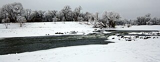
The Red River is a river in the north-central United States and central Canada. Originating at the confluence of the Bois de Sioux and Otter Tail rivers between the U.S. states of Minnesota and North Dakota, it flows northward through the Red River Valley, forming most of the border of Minnesota and North Dakota and continuing into Manitoba. It empties into Lake Winnipeg, whose waters join the Nelson River and ultimately flow into Hudson Bay.

<span class="mw-page-title-main">Hurricane Floyd</span> Category 4 Atlantic hurricane in 1999

Hurricane Floyd was a very powerful Cape Verde hurricane which struck the Bahamas and the East Coast of the United States. It was the sixth named storm, fourth hurricane, and third major hurricane in the 1999 Atlantic hurricane season. Floyd triggered the fourth largest evacuation in US history when 2.6 million coastal residents of five states were ordered from their homes as it approached. The hurricane formed off the coast of Africa and lasted from September 7 to 19, becoming extratropical after September 17, and peaked in strength as a very strong Category 4 hurricane. It was among the largest Atlantic hurricanes of its strength ever recorded, in terms of gale-force diameter.

<span class="mw-page-title-main">Hurricane Agnes</span> Category 1 Atlantic hurricane in 1972

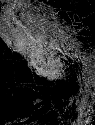
Hurricane Agnes was the costliest hurricane to hit the United States at the time, causing an estimated $2.1 billion in damage. The hurricane's death toll was 128. The effects of Agnes were widespread, from the Caribbean to Canada, with much of the east coast of the United States affected. Damage was heaviest in Pennsylvania, where Agnes was the state's wettest tropical cyclone. Due to the significant effects, the name Agnes was retired in the spring of 1973.

<span class="mw-page-title-main">1997 Red River flood</span> Major flood on the Red River of the North

The Red River flood of 1997 was a major flood that occurred in April and May 1997 along the Red River of the North in Minnesota, North Dakota, and southern Manitoba. It was the most severe flood of the river since 1826. The flood reached throughout the Red River Valley, affecting the cities of Fargo and Winnipeg, but none so greatly as Grand Forks and East Grand Forks, where floodwaters reached more than 3 miles (4.8 km) inland. They inundated virtually everything in the twin communities. Total damages for the Red River region were US$3.5 billion. The flood was the result of abundant snowfall and extreme temperatures.

<span class="mw-page-title-main">Hurricane Diane</span> Category 2 Atlantic hurricane in 1955

Hurricane Diane was the first Atlantic hurricane to cause more than an estimated $1 billion in damage, including direct costs and the loss of business and personal revenue. It formed on August 7 from a tropical wave between the Lesser Antilles and Cape Verde. Diane initially moved west-northwestward with little change in its intensity, but began to strengthen rapidly after turning to the north-northeast. On August 12, the hurricane reached peak sustained winds of 105 mph (165 km/h), making it a Category 2 hurricane. Gradually weakening after veering back west, Diane made landfall near Wilmington, North Carolina, as a strong tropical storm on August 17, just five days after Hurricane Connie struck near the same area. Diane weakened further after moving inland, at which point the United States Weather Bureau noted a decreased threat of further destruction. The storm turned to the northeast, and warm waters from the Atlantic Ocean helped produce record rainfall across the northeastern United States. On August 19, Diane emerged into the Atlantic Ocean southeast of New York City, becoming extratropical two days later and completely dissipating by August 23.

Livermore, Pennsylvania is an abandoned town that was located on the Conemaugh River between Blairsville and Saltsburg in Derry Township, Westmoreland County, Pennsylvania. The town was abandoned and partially razed in the early 1950s following authorization by the Flood Control Act of 1936 and Flood Control Act of 1938 for construction of the Conemaugh Dam and Lake to prevent flooding of Pittsburgh. Much of the former town site now lies under the reservoir and floodplains.

<span class="mw-page-title-main">Northeast U.S. flooding of October 2005</span>

In October 2005, remnants of Tropical Storm Tammy and Subtropical Depression Twenty-Two merged with incoming continental cold fronts to produce torrential rains over interior New England, as well as over parts of New Jersey and New York. Particularly hard hit was the state of New Hampshire, which saw roads and bridges wiped out, several reported deaths, and whole buildings destroyed. Rain lingered over some areas for several weeks. Rainfall from both rain events totaled well over 20 inches (510 mm) in some areas.

<span class="mw-page-title-main">Mill River (Northampton, Massachusetts)</span> Tributary of the Connecticut River in Hampshire County, Massachusetts, USA

The Mill River is a 13.5-mile-long (21.7 km) tributary of the Connecticut River arising in the western hilltowns of Hampshire County, Massachusetts. It is notable for dropping in elevation, along with its West Branch, more than 700 feet (210 m) over 15 miles (24 km).

<span class="mw-page-title-main">2006 Mid-Atlantic United States flood</span>

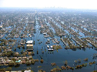
The Mid-Atlantic United States flood of 2006 was a significant flood that affected much of the Mid-Atlantic region of the eastern United States. The flooding was very widespread, affecting numerous rivers, lakes and communities from Upstate New York to North Carolina. It was widely considered to be the worst flooding in the region since Hurricane David in 1979. It was also one of the worst floodings in the United States since Hurricane Katrina in August 2005. At least 16 deaths were related to the flooding.

<span class="mw-page-title-main">Los Angeles flood of 1938</span> 1938 flood in Southern California, United States

The Los Angeles flood of 1938 was one of the largest floods in the history of Los Angeles, Orange, and Riverside Counties in southern California. The flood was caused by two Pacific storms that swept across the Los Angeles Basin in February-March 1938 and generated almost one year's worth of precipitation in just a few days. Between 113–115 people were killed by the flooding. The Los Angeles, San Gabriel, and Santa Ana Rivers burst their banks, inundating much of the coastal plain, the San Fernando and San Gabriel Valleys, and the Inland Empire. Flood control structures spared parts of Los Angeles County from destruction, while Orange and Riverside Counties experienced more damage.

Floods in the United States are generally caused by excessive rainfall, excessive snowmelt, and dam failure. Below is a list of flood events that were of significant impact to the country during the 20th century, from 1900 through 1999, inclusive.

<span class="mw-page-title-main">Ohio River flood of 1937</span> 1937 flood

The Ohio River flood of 1937 took place in late January and February 1937. With damage stretching from Pittsburgh to Cairo, Illinois, 385 people died, one million people were left homeless and property losses reached $500 million. Federal and state resources were strained to aid recovery as the disaster occurred during the depths of the Great Depression and a few years after the beginning of the Dust Bowl.

Floods in the United States before 1900 is a list of flood events that were of significant impact to the country, before 1900. Floods are generally caused by excessive rainfall, excessive snowmelt, and dam failure.

<span class="mw-page-title-main">Floods in the United States (2000–present)</span>

Floods in the United States (2000–present) is a list of flood events which were of significant impact to the country during the 21st century, since 2000. Floods are generally caused by excessive rainfall, excessive snowmelt, storm surge from hurricanes, and dam failure.

<span class="mw-page-title-main">Hartford–East Hartford railroad bridge</span> Railroad bridge in Hartford, Connecticut

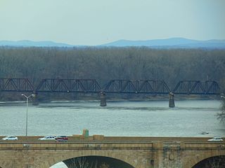
The Hartford–East Hartford railroad bridge is a 5-span truss bridge connecting Hartford and East Hartford, Connecticut, over the Connecticut River. The bridge is 1,240 feet in length and 18.3 feet in width and was built ca. 1873 by the Hartford, Providence and Fishkill Railroad. The bridge is currently owned and maintained by the Connecticut Southern Railroad and carries freight traffic.

<span class="mw-page-title-main">Great Flood of 1913</span> Natural disaster affecting the southern and eastern United States

The Great Flood of 1913 occurred between March 23 and March 26, after major rivers in the central and eastern United States flooded from runoff and several days of heavy rain. Related deaths and damage in the United States were widespread and extensive. While the exact number is not certain, flood-related deaths in Ohio, Indiana, and eleven other states are estimated at approximately 650. The official death toll range for Ohio falls between 422 and 470. Flood-related death estimates in Indiana range from 100 to 200. More than a quarter million people were left homeless. The death toll from the flood of 1913 places it second to the Johnstown Flood of 1889 as one of the deadliest floods in the United States. The flood remains Ohio's largest weather disaster. In the Midwestern United States, damage estimates exceeded a third of a billion dollars. Damage from the Great Dayton Flood at Dayton, Ohio, exceeded $73 million. Indiana's damages were estimated at $25 million. Further south, along the Mississippi River, damages exceeded $200 million. Devastation from the flood of 1913 and later floods along the Mississippi River eventually changed the country's management of its waterways and increased federal support for comprehensive flood prevention and funding for flood control projects. The Ohio Conservancy Act, which was signed by the governor of Ohio in 1914, became a model for other states to follow. The act allowed for the establishment of conservancy districts with the authority to implement flood control projects.

<span class="mw-page-title-main">1985 Election Day floods</span> Series of disastrous floods in the Mid-Atlantic States

The 1985 Election Day floods — also known as the Killer Floods of 1985 in West Virginia — produced the costliest floods in both West Virginia and Virginia in November 1985. The event occurred after Hurricane Juan, a tropical cyclone in the 1985 Atlantic hurricane season, meandered near the coast of Louisiana before striking just west of Pensacola, Florida late on October 31. Juan moved northward into Canada, but spawned another system that spread moderate rainfall across the Mid-Atlantic States, wetting soils. On November 3, a low pressure area developed south of Florida and moved northeastward along a cold front, bringing a plume of moisture influenced by Juan's previous track. The storm moved through the southeastern United States, stalling on November 5 west of Washington, D.C. before turning out to sea the next day. The event was known as the Election Day floods due to its concurrence with elections in Virginia.

<span class="mw-page-title-main">Effects of Hurricane Floyd in New Jersey</span>

Hurricane Floyd in 1999 was the costliest natural disaster in New Jersey's history, until it was surpassed by Hurricane Irene in 2011. Damage in the state totaled $250 million (1999 USD), much of it in Somerset and Bergen counties. Seven people died in New Jersey during Floyd's passage – six due to drowning, and one in a traffic accident. A police lieutenant took his life after coordinating floodwater rescues for nearly 48 hours.

<span class="mw-page-title-main">Pittsburgh flood of 1936</span> 1936 flooding in the Mid-Atlantic United States, most severely in Pittsburgh, Pennsylvania

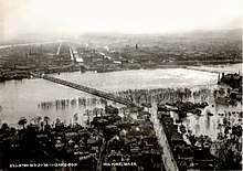
On March 17 and 18, 1936, the city of Pittsburgh, Pennsylvania, witnessed the worst flood in its history when flood levels peaked at 46 feet (14 m). This flood became known as The Great St. Patrick’s Day flood, and also affected other areas of the Mid-Atlantic on both sides of the Eastern Continental Divide.

<span class="mw-page-title-main">2019 Midwestern U.S. floods</span> 2019 disaster in the Midwestern United States

The Midwestern United States experienced major floods in the spring of 2019, primarily along the Missouri River and its tributaries in Nebraska, Missouri, South Dakota, Iowa, and Kansas. The Mississippi River also saw flooding, although starting later and ending earlier. The 2019 January-to-May period was the wettest on record for the U.S., with multiple severe weather outbreaks through May in the Midwest, High Plains, and South exacerbating the flooding and causing additional damage. Throughout late May and early June, rain in Iowa, Illinois, and Missouri caused every site on the Mississippi River to record a top-five crest. At least three people in Iowa and Nebraska died.

References

  1. 1 2 3 4 5 6 7 US Department of Commerce, NOAA. "Historic Flood March 1936". www.weather.gov. Retrieved October 6, 2021.
  2. 1 2 3 4 5 6 7 8 9 10 United States Geological Survey (1936). The Floods of March 1936 (PDF). Washington, D.C.: United States Government Printing Office.
  3. "Value of $100,000,000 from 1936 to 2023". www.in2013dollars.com. Retrieved March 18, 2023.
  4. 1 2 "The Flood of 1936". Springfield Museums. March 30, 2016. Retrieved October 6, 2021.
  5. "Nine Lose Lives As Floods Sweep East". Painesville Telegraph . March 13, 1936. Retrieved October 9, 2021.
  6. 1 2 3 Associated Press (March 12, 1936). "Worst Conn. Floods In Years Cause Widespread Destruction". The Day . Retrieved October 9, 2021.
  7. 1 2 "20 Dead in Floods; Cold Halts Menace". Rochester Journal . March 13, 1936. Retrieved October 9, 2021.
  8. Associated Press (March 20, 1936). "The Floods at a Glance". Pittsburgh Post-Gazette . Retrieved October 6, 2021.
  9. 1 2 United Press (March 19, 1936). "Flood Toll Mounting in Ohio Valley". The Bulletin . Retrieved October 6, 2021.
  10. 1 2 3 Associated Press (March 21, 1936). "Connecticut Towns Menaced By New Flood Crest". Spokane Daily Chronicle . Retrieved October 7, 2021.
  11. 1 2 3 Arnold, Joseph L. (1988). The Evolution of the 1936 Flood Control Act (PDF). Washington, D.C.: United States Government Printing Office.
  12. United Press (March 19, 2021). "Loss Mounts as Dam Gives Way". Berkeley Daily Gazette . Retrieved October 6, 2021.
  13. "Floods Claim 143 Lives!". Oxnard Daily Courier . March 20, 1936. Retrieved October 6, 2021.
  14. Associated Press (March 20, 1936). "15% of Hartford Flooded, All Business May Suspend; 2 More Feet of Water Will Cripple Main Power Plant". Meriden Daily Journal . Retrieved October 7, 2021.
  15. Associated Press (March 20, 1936). "Middletown Industries Close As Power Fails". Meriden Daily Journal . Retrieved October 7, 2021.
  16. "Photos: Rhode Island disasters". providencejournal.com. Retrieved October 6, 2021.
  17. 1 2 3 US Department of Commerce, NOAA. "1936 Flood Retrospective". www.weather.gov. Retrieved October 7, 2021.
  18. Associated Press (March 20, 1936). "Weatherman Explains How "Perfect Storm" Caused Flood Of The Century". Meriden Daily Journal . Retrieved October 7, 2021.
  19. Nathan C. Grover; Stephen Lichtblau (1937). The Floods of March 1936. Part 3. Potomac, James, and Upper OHIO RIVERS (PDF) (Report). United States Geological Survey . Retrieved July 18, 2014.
  20. "Floods". Great Falls Park . National Park Service. June 24, 2014. Retrieved July 18, 2014.
  21. Grover and Lichtblau, The Floods of March 1936, Photographic Plate 2 (between pp. 34–35)
  22. 1 2 Bloom, Chester A. (March 30, 1936). "The Flood Stole the Show". Saskatoon Star-Phoenix . Retrieved October 6, 2021.
  23. "Flood of 1936". National Archives at College Park. March 20, 1936. Archived from the original on May 21, 2015. Retrieved October 6, 2021.
  24. "State Escapes Havoc of Flood Waters". The Sunday Morning Star . March 29, 1936. Retrieved October 6, 2021.