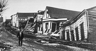
The 1960 Valdivia earthquake and tsunami or the Great Chilean earthquake on 22 May 1960 was the most powerful earthquake ever recorded. Various studies have placed it at 9.4–9.6 on the moment magnitude scale. It occurred in the afternoon, and lasted for approximately 10 minutes. The resulting tsunamis affected southern Chile, Hawaii, Japan, the Philippines, eastern New Zealand, southeast Australia, and the Aleutian Islands.
The 2006 Mendoza earthquake was a medium-intensity seismic movement in the province of Mendoza, Argentina. It took place at 11:03 AM (UTC-3) on 5 August 2006, and had a magnitude of 5.6 in the Richter scale. Its hypocenter was centered 23 km west southwest of San Martin, exactly at the town of Ugarteche, Luján de Cuyo, and at a depth of 25 km.
The 1985 Mendoza earthquake occurred with medium intensity in the province of Mendoza, Argentina. It took place 7 minutes after midnight on 26 January 1985, and had a magnitude of 6.2 in the Richter scale. Its epicenter was located about 45 km southwest of Mendoza, the provincial capital, at the southern end of the region's pre-Andes range, and at a depth of 5 km. It was felt as grade VIII in the Mercalli intensity scale.

The 1977 San Juan earthquake, also known as Caucete earthquake, took place in the province of San Juan, Argentina, on 23 November at 06:26:26 AM. It measured 7.4 on the surface wave magnitude scale, and had a maximum perceived intensity of X (Extreme) on the Mercalli intensity scale.
The 1894 San Juan earthquake took place in the province of San Juan, Argentina, on 27 October 1894, at about 07:30 PM. It was the most powerful earthquake recorded in Argentina, with magnitude 7.5 on the surface wave magnitude scale. Its epicenter was located to the northwest of San Juan, approximately at 29°48′S69°00′W, and at a depth of 30 km.
The 1952 San Juan earthquake took place on 11 June at 00:31:43 UTC in the province of San Juan, Argentina. It measured 6.8 on the moment magnitude scale with a depth of 30 kilometers (19 mi). The earthquake was felt in San Juan with a maximum of VIII (Severe) on the Mercalli intensity scale. It caused damage in some locations in the south and west of the province, and a small number of casualties.
Averías is a municipality and village in the General Taboada department, province of Santiago del Estero Province in Argentina. It is located approximately 229 km from the provincial capital city of Santiago del Estero.
San Carlos is a head village of the department of San Carlos, Province of Salta, Argentina. San Carlos is a historic village in Calchaquíes Valleys located at the National Route 40, 27 km from Cafayate.
The 1787 Boricua earthquake struck offshore of the island of Puerto Rico on May 2. The magnitude of the earthquake was believed to have been around 8.0–8.25, however there is evidence that it was only about 6.9. The epicenter is thought to have been somewhere north of Puerto Rico, probably on the Puerto Rico Trench. Puerto Rican geomorphologist José Molinelli considers it "the strongest" in the seismic history of the country.
The 2011 Guerrero earthquake struck with a moment magnitude of 5.7 in southern Mexico at on 5 May. It was positioned west of Ometepec, Guerrero, with a focal depth of 24 km (14.9 mi), and was lightly felt in many adjacent areas.
The 2003 Puerto Armuelles earthquake occurred on December 25 at 02:11 local time. The epicenter was located in Panama, at about 7 km east of Puerto Armuelles, near the Panama-Costa Rica border. The earthquake had a magnitude of 6.5. Two people were reported dead in Puerto Armuelles. There was building damage in Panama and Costa Rica. Power outage lasted for about four hours in Puerto Armuelles. The maximal intensity was MM VIII in Finca Naranjo, Costa Rica. The intensity was MM VII in Armuelles, Panama, and MM IV in Limón and the Central Valley, Costa Rica, including San José. This earthquake could also be felt in Panama City.
The 1927 Mendoza earthquake took place in Mendoza Province, in the Republic of Argentina, on 14 April at 06:23:28 UTC. It registered a magnitude of 7.1 on the Richter magnitude scale. The earthquake was located at a depth of 110 kilometres (68 mi).
The department of Tafí Viejo is a department of the province of Tucumán (Argentina), created in 1907 by the reform of the provincial constitution, which divided the old department Tafí. Its head is the homonymous city. Bordered on the north by the department Trancas, east to Burruyacú and Cruz Alta, south of Capital, Yerba Buena and Lules, and west to Tafí del Valle.

The 2017 Puebla earthquake, also known as 19S, struck at 13:14 CDT on 19 September 2017 with an estimated magnitude of 7.1 and strong shaking for about 20 seconds. Its epicenter was about 55 km (34 mi) south of the city of Puebla, Mexico. The earthquake caused damage in the Mexican states of Puebla and Morelos and in the Greater Mexico City area, including the collapse of more than 40 buildings. 370 people were killed by the earthquake and related building collapses, including 228 in Mexico City, and more than 6,000 were injured.
Starting on December 28, 2019, and progressing into 2020, the southwestern part of the island of Puerto Rico was struck by an earthquake swarm, including 11 that were of magnitude 5 or greater. The largest and most damaging of this sequence was a magnitude 6.4 , which occurred on January 7 at 04:24 AST (08:24 UTC), with a maximum felt intensity of VIII (Severe) on the Modified Mercalli intensity scale. At least one person was killed, and several others were injured.
The 1900 Venezuelan earthquake, occurred on October 28 at between 4:30 and 4:45 am local time. This earthquake had an epicenter off Miranda State or near the Venezuelan capital Caracas, in the Cariaco Basin. It had an estimated moment magnitude of 7.6–7.7 and a surface-wave magnitude of 7.7–8.4. It had a maximum Mercalli intensity assigned VIII–X, causing landslides and liquefaction events. Many buildings were severely damaged or collapsed during the earthquake. It is thought to be the last great earthquake of the 19th century and the largest instrumentally recorded in the republic, having been felt throughout.
Villa Ibáñez is a locality located in the south-central province of San Juan, west of the agricultural oasis of Ullúm, northwest of the city of San Juan, Argentina. It is the seat of the Ullúm Department. Today, the town is the nucleus of an important wine, fruit and olive region par excellence of the aforementioned province.
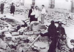
The 1910 Costa Rica earthquakes were a series of destructive seismic events that affected Cartago, Costa Rica from 13 April to 4 May. The sequence began with a Ms 5.8 earthquake. The largest and most destructive in the sequence occurred on 4 May, measuring Ms 6.4. A total of 2,450 people were killed and the city of Cartago was severely affected.


