The 1972 Pacific typhoon season was an above average season, producing 31 tropical storms, 24 typhoons and 2 intense typhoons. It has no official bounds; it ran year-round in 1972, but most tropical cyclones tend to form in the northwestern Pacific Ocean between June and December. These dates conventionally delimit the period of each year when most tropical cyclones form in the northwestern Pacific Ocean.
The scope of this article is limited to the Pacific Ocean, north of the equator and west of the International Date Line. Storms that form east of the date line and north of the equator are called hurricanes; see 1972 Pacific hurricane season. Tropical Storms formed in the entire west Pacific basin were assigned a name by the Joint Typhoon Warning Center. Tropical depressions in this basin have the "W" suffix added to their number. Tropical depressions that enter or form in the Philippine area of responsibility are assigned a name by PAGASA (the Philippine Atmospheric, Geophysical and Astronomical Services Administration. This can often result in the same storm having two names.
Systems
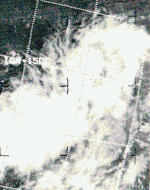
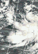
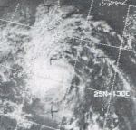
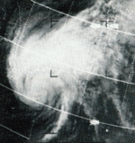
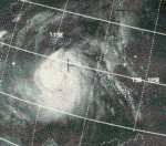
This ESSA 9 weather satellite mosaic image captures Tropical Cyclones Susan (A), Rita (B), Phyllis (C), and Tess (D) across the northwest Pacific Ocean on July 13, 1972
A total of 36tropical depressions formed this year in the Western Pacific, of which 30 became tropical storms. Twenty-two storms reached typhoon intensity, of which two reached super typhoon strength.[1]
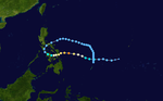
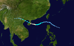
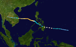
A tropical disturbance generated by an upper tropospheric low in the mid-Pacific trough moved westward through the Caroline Islands, slowly organizing into Tropical Depression 1W on January 5. The depression quickly strengthened, reaching tropical storm status later that day and becoming a typhoon on the 6th as it neared the Philippines. Kit rapidly intensified on the 6th and 7th to a 140mph (230km/h) typhoon, the strongest ever in January, but its inflow was cut off to the west, weakening the typhoon as it continued westward. Kit hit the eastern Philippines as a 100mph (200km/h) typhoon on January 7, and turned north through the archipelago in response to a break in the subtropical ridge. This brought Kit eastward then southward, where after completing its large loop it dissipated on January 15, just 170 nautical miles (310km) from its starting location.[2]
This unusual, unexpected, and unseasonably strong typhoon killed 204 people and caused nearly $23million in damage (1972USD) in the Philippines. The destruction was mostly due to rains and flooding.[2]
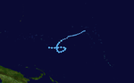
The northern hemisphere part of a "cyclone twin" developed into a tropical depression west of Kwajalein on May 29. It headed west and slowly strengthened. As it turned to the northwest and then the north northeast, it reached its maximum intensity on June 5. It continued heading north northeast, steadily weakened, and went extratropical on June 7.[3]
Lola passed close enough to some of the islands in Micronesia to cause damage. Two fishermen were reported missing. Wind and waves caused $18thousand (1972 USD) in damage to Pohnpei and nearby atolls. They also destroyed the fresh water system, causing a shortage of drinking water. On Pingelap and Mokil, sixty houses were destroyed.[3]
Tropical Storm Nina formed as a disturbance heading westwards. It briefly became a tropical depression south of Guam, but it weakened back to a disturbance as it turned back eastwards. As it traveled eastwards, it reintensified, becoming a tropical storm late on the 3rd while far east-southeast of Guam. It did not last, though, weakening back to a disturbance on the 4th and dissipating on the 5th.
Tropical Storm Mamie formed as a disturbance over the Philippines. It traveled westwards, becoming a tropical depression over the South China Sea, and then becoming a tropical storm on the 1st. The tropical storm made landfall in Vietnam late on the 3rd. It weakened to a tropical depression over land, and it became non-tropical as it went offshore. The extratropical remnants of Mamie traveled northeastwards along the Chinese coast, finally dissipating over Hokkaido.
Typhoon Ora, which formed on June 22, crossed the northern Philippines on the 24th and 25th as an 85mph (137km/h) typhoon. It weakened over land, but restrengthened in the South China Sea to a 90mph (140km/h) typhoon before hitting southern China on June 27. An unusual feature about Ora was while crossing the South China Sea, it never featured a wall cloud, even though it had winds of typhoon strength.[4]
Ora caused heavy damage to the Manila area in the Philippines. It killed 131 people, including four who died when a ferry in the Bicol region capsized. In Manila Harbor, several ships were blown ashore. All in all, Ora left 385 thousand people homeless and caused $15million (1972USD) in damage.[4]
Tropical Storm Phyllis, which formed on July 5, quickly intensified from late on July 9 to early July 11 to a 140mph (230km/h) typhoon. The typhoon turned to the northwest, steadily weakening as it approached Japan. Phyllis struck southeastern Japan on July 15 as a tropical storm, and became extratropical that night.[5]
In Japan, Phyllis caused 3 deaths, more than 300 landslides, and flooded more than 6000 homes. Overall damage was moderate.[5]
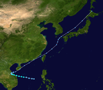
The near-equatorial trough spawned four tropical cyclones on July 5, one of which would become Super Typhoon Rita. Having originated over the open Western Pacific, the depression tracked westward, becoming a tropical storm on July 7 and a typhoon the next day. Rita quickly intensified, reaching super typhoon strength on July 10 and a peak of 165mph (266km/h) on July 11. The typhoon stalled and weakened over the next two days as it headed to the northeast. On the July 15 and July 16, Rita again stalled, weakening down to 75mph (121km/h), as Tropical Storm Phyllis swung around its circulation and struck Japan. Rita then turned to the north, where it was able to restrengthen. Typhoon Tess at that time was just located some 800nm east of Rita. A Fujiwhara interaction took place, forcing Rita executed a large loop from July 21 to July 25. In that loop the Rita caught USS Alamo and USS Juneau as they sought to evade to the south after dropping of US Marines and equipment in Okinawa. Both ships weathered the storm but Alamo sustained minor damage in the plunging seas. After looping and passing Okinawa, she continued to the northwest and began to accelerate as she entered a confluent zone created by a trough over Manchuria and a building ridge over the Sea of Japan. She passed by western South Korea, made landfall at Shidao port, Shandong and then weakened into a tropical storm. Rita entered the Bohai Sea, hit northeastern China, and dissipated over the Yanshan mountain northwest of Peking, China on the night of July 27.[6]
Rita's large size and long life caused heavy rains throughout the areas it hit.[6] Rita and Tropical Storm Susan's presence strengthened the southwest monsoon flow over Luzon, where torrential rains occurring between July 17 and July 21 lead to disastrous flooding which killed 214 and with over $150million in damage.[7] Near Guam, on July 8, the typhoon caused an Air Force Boeing B-52 to crash into the ocean, killing one member of its six-man crew. The remaining crew members were rescued by a US Navy nuclear attack submarine which surfaced in the roiling seas and literally fished the men out by using a line attached to a periscope and reeling them in as the boat rolled in the seas. In Taiwan, heavy rains caused landslides, one of which derailed a train, killing three. In Korea, eight people were killed, more fifty small vessels were lost, and more than two hundred buildings were destroyed. In the Ryukyu Islands, three people were killed. Crop damage was heavy, numerous boats were sunk, and several highways were blocked by mudslides.[6]
Rita killed 229 people, making it this season's deadliest typhoon.[1]
A disturbance in the ITCZ became a tropical depression on July 5. It headed northwest over the Philippines. It intensified into a tropical storm almost immediately after entering the South China Sea on July 8. It then turned north, and erratically drifted and looped for four days. On July 11, Susan became a typhoon. On July 14, Susan moved close to the Taiwan Strait. It made landfall on the coast of Fujian province, and dissipated inland on July 15.[8]
Susan caused heavy waves on the western coast of Luzon. Along with Super Typhoon Rita, Susan altered the monsoon winds over the Philippines,[8] which caused flooding that killed 214 people;[7] however, as Rita was primarily responsible for these conditions,[8] the Joint Typhoon Warning Center attributes these deaths to the former system.[1] By itself, Susan killed four people in Taiwan.[8] Typhoon Susan sank the SS Oriental Falcon on 12 July 1972 after it ran aground in South China.
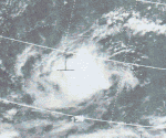
The same near-equatorial trough that developed Rita also developed Typhoon Tess. Tess, having developed on July 7 near the Marshall Islands, tracked westward, reaching typhoon status on July 12. Over the next two days, as Tess turned to the northwest, it rapidly intensified to a 145mph (233km/h) typhoon. Steadily weakening as it continued northwestward, Tess bent back to the west in response to the building of a high pressure cell over Japan. The Fujiwhara effect between Tess and Rita brought 75mph (121km/h) Typhoon Tess into Japan on July 23. After dissipating over Sea of Japan, Tess continued northward, and merged with a front south of Vladivostok on July 25.[9]
In Japan, Tess caused strong flooding and strong surf. This killed 29 people, with 20 missing. These casualties were mostly swimmers caught in the surf.[9]
Typhoon Viola (classified as a tropical storm by the JTWC) spent its entire life far offshore. Its precursor disturbance formed south of Wake Island on the 21st, and it traveled westwards then northwards at around 160 degrees west, before turning back eastwards on the 24th and eventually becoming extratropical on the 26th.
Tropical Storm Winnie formed as a disturbance far east of the Philippines. The disturbance did a small loop, then headed northwestwards, intensifying into a tropical storm at midnight on the 30th. It continued, traveling north of the island of Taiwan before making landfall in China on the 1st of August. The storm quickly weakened into a disturbance, which traveled slowly inland before dissipating.
A tropical disturbance emerged from the ITCZ on July 29 and passed through the Marshalls. It became a tropical depression on July 30 and a tropical storm the next day. It and headed in the direction of Japan. Alice became a typhoon on August 2 and reached its maximum intensity on August 4 while southwest of Marcus. As Alice continued approaching Japan, it steadily weakened. It recurved, brushed Honshu, and went extratropical on August 8. It never made landfall.[10]
Waves generated by Alice's storm surge caused a river to overflow in Iwaki, which affected three hundred houses. No one was killed.[10]
A tropical depression formed near the Caroline Islands on August 8. It passed through the Marianas Islands after becoming a tropical storm. Betty turned to the west and peaked as a super typhoon on August 15. It turned to more to the west northwest, passed over the southern Ryukyus and just north of Taiwan, and made landfall on the coast China on August 17. It rapidly weakened inland, and dissipated the next day.[11]
Betty had minimal effects in the Ryukyu Islands. In the Philippines, it enhanced monsoon rains. This caused flooding, which killed seven people in Ilocos Sur. Four other people were presumed dead after a light aircraft went missing. In Taiwan, rains were heavy. The resulting floods in Sanchong District stranded 300thousand people, and washed out roads and railways. More than 220 houses were totally destroyed, with at least another 130 badly damaged. Betty killed eighteen people in Taiwan, and twenty-nine overall. The total cost of damage is unknown.[11]
A disturbance west of Luzon became a tropical depression on August 22. It headed into the South China Sea and strengthened into a tropical storm. As it approached Hainan, it became only the fourth August tropical cyclone to intensify into a typhoon in the South China Sea since 1945. It made landfall on Hainan on August 28, emerged into the Gulf of Tonkin, and made a second landfall north of Haiphong. Cora had dissipated inland by August 29.[12]
No damage was reported, and no one was killed.[13]
Tropical Storm Doris stayed far from land. It formed far north of Wake Island and traveled north, becoming a tropical storm on the 26th, but it became extratropical on the 29th and dissipated shortly thereafter.
West of Leyte Gulf, a tropical depression formed on August 30. It intensified into a tropical storm after entering the South China Sea. It strengthened into a typhoon on September 1 and slowed down. It made landfall in northern South Vietnam on September 4. It rapidly weakened inland but kept its identity. It transited the Indochina Peninsula[13] and emerged into the Bay of Bengal on September 7, becoming Tropical Cyclone 24-72 of the 1972 North Indian Ocean cyclone season. Ex-Elsie gradually restrengthened as it crossed the Bay of Bengal. It made landfall on the coast of India on September 10 and rapidly dissipated inland.[14]
While crossing Thailand, Elsie caused heavy flooding.[12] No other impact was reported to the JTWC.[1][14]
Typhoon Flossie formed as a disturbance west of Guam late on the 5th of September. The system intensified into a tropical storm just before landfall on Luzon. The cyclone then traveled slowly across the South China Sea, becoming a low-level typhoon before making landfall in Vietnam on the 16th. It weakened to a tropical depression as it crossed Vietnam, but it reintensified after entering the Bay of Bengal as Tropical Cyclone 25-72.[15]
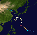
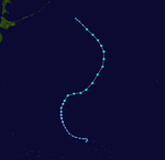
Typhoon Helen was the most destructive tropical cyclone to strike Japan during the 1972 Pacific typhoon season. Originating from a tropical disturbance on September11 near the Northern Mariana Islands, Helen gradually intensified as it moved northwestward. By September14, it reached typhoon strength and soon turned northeast towards Japan. Accelerating due to a trough over the East China Sea, Helen rapidly approached the country and made landfall near Cape Kushimoto as a Category3-equivalent typhoon on the Saffir–Simpson hurricane scale. Later that day, a weakened Helen emerged into the Sea of Japan. After merging with an upper-level low, the storm transitioned into an extratropical cyclone on September19 and was last noted two days later after moving through southern Hokkaido.
In Japan, Typhoon Helen produced torrential rain, peaking at 790mm (31in) in Hokkaido, and damaging winds that caused widespread damage. A total of 4,213 homes were destroyed and another 146,547 were damaged as a result of flash flooding and landslides. Numerous vessels ran aground due to rough seas associated with the storm, including several thousand ton cargo freighters. In all, 87 fatalities and $102million in damage was attributed to Typhoon Helen.
Typhoon Marie formed on October 4 and tracked westwards, while it intensified into a category 4 typhoon. Soon after reaching peak intensity, Marie weakened and turned northward and affected the northern Soviet Union and Japan until it transitioned into an extratropical cyclone on October 16. Marie did not inflict much damage during its 12-day duration.
On November 30, a low-pressure area formed near Borneo, before moving westwards towards the Gulf Of Thailand and eventually becoming Typhoon Sally. Typhoon Sally made landfall near the Surat Thani province of Thailand and gradually weakened to a remnant low in the Bay of Bengal on December 2, dissipating in the same area.
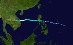
Typhoon Therese, having developed on November 30, struck the Philippines on December 3. After crossing the islands, the typhoon reached a peak of 120mph (190km/h) winds in the South China Sea, a rare event for December. Therese's intensity fluctuated as it continued westward, and hit eastern South Vietnam on the 9th as a 115mph (185km/h) typhoon. Therese dissipated on the 12th, after causing 90 deaths and extensive damage on its path.
During the season 29 named tropical cyclones developed in the Western Pacific and were named by the Joint Typhoon Warning Center, when it was determined that they had become tropical storms. These names were contributed to a revised list from late 1950.
Two Central Pacific system developed, Tropical Storms June and Ruby. The naming policy at the time was to use Western Pacific names the Central Pacific.
The Philippine Atmospheric, Geophysical and Astronomical Services Administration uses its own naming scheme for tropical cyclones in their area of responsibility. PAGASA assigns names to tropical depressions that form within their area of responsibility and any tropical cyclone that might move into their area of responsibility. Should the list of names for a given year prove to be insufficient, names are taken from an auxiliary list, the first 6 of which are published each year before the season starts. Names not retired from this list will be used again in the 1976 season. This is the same list used for the 1968 season. PAGASA uses its own naming scheme that starts in the Filipino alphabet, with names of Filipino female names ending with "ng" (A, B, K, D, etc.). Names that were not assigned/going to use are marked in gray.
Season effects
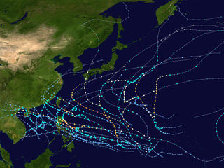
This table will list all the storms that developed in the northwestern Pacific Ocean west of the International Date Line and north of the equator during 1972. It will include their intensity, duration, name, areas affected, deaths, missing persons (in parentheses), and damage totals. Classification and intensity values will be based on estimations conducted by the JMA, however due to lack of information around this time sustained winds were recorded by the JTWC. All damage figures will be in 1972USD. Damages and deaths from a storm will include when the storm was a precursor wave or an extratropical low.
South-West Indian Ocean cyclone seasons: 1971–72, 1972–73
Related Research Articles
The 2005 Pacific typhoon season was the least active typhoon season since 2000, producing 23 named storms, of which 13 became typhoons. It was an event in the annual cycle of tropical cyclone formation, in which tropical cyclones form in the western Pacific Ocean. The season ran throughout 2005, though most tropical cyclones typically develop between May and October. The season's first named storm, Kulap, developed on January 13, while the season's last named storm, Bolaven, dissipated on November 20. The season's first typhoon, Haitang, reached typhoon status on July 13, and became the first super typhoon of the year three days later.
The 2004 Pacific typhoon season was an extremely active season that featured the second-highest ACE ever recorded in a single season, second only to 1997, which featured 29 named storms, nineteen typhoons, and six super typhoons. It was an event in the annual cycle of tropical cyclone formation, in which tropical cyclones form in the western Pacific Ocean. The season ran throughout 2004, though most tropical cyclones typically develop between May and October. The season's first named storm and also the first typhoon, Sudal, developed on April 4, later was reached typhoon status two days later, and became the first super typhoon of the year three days later. The season's last named storm, Noru, dissipated on December 21.
The 1999 Pacific typhoon season was the last Pacific typhoon season to use English names as storm names. It also featured the lowest number of typhoons on record, with only five reaching this intensity. This was mainly due to a strong La Niña which persisted from last year. The season was also below-average in named storms, with only 20 of such spawning. It had no official bounds; it ran year-round in 1999, but most tropical cyclones tend to form in the northwestern Pacific Ocean between May and November. These dates conventionally delimit the period of each year when most tropical cyclones form in the northwestern Pacific Ocean. The first named storm, Hilda, developed on January 6, while the last named storm, Gloria, dissipated on November 16.
The 1998 Pacific typhoon season was the least active Pacific typhoon season on record, until it was surpassed 12 years later. It would produce 16 tropical storms, 8 strengthening into typhoons. The scope of this article is limited to the Pacific Ocean, north of the equator and west of the international date line. Storms that form east of the date line and north of the equator are called hurricanes; see 1998 Pacific hurricane season. Tropical Storms formed in the entire west Pacific basin were assigned a name by the Joint Typhoon Warning Center. Tropical depressions in this basin have the "W" suffix added to their number. Tropical depressions that enter or form in the Philippine area of responsibility are assigned a name by the Philippine Atmospheric, Geophysical and Astronomical Services Administration or PAGASA. This can often result in the same storm having two names.
The 1997 Pacific typhoon season was a record-breaking season featuring 11 tropical cyclones reaching super typhoon intensity, tying the record with 1965 with the most violent tropical cyclones globally, and was the ninth and last consecutive year of above-average tropical cyclone activity that started in 1989. Its extremely high activity produced a total of 570 ACE index, which is the highest ever index recorded in a single tropical cyclone season. In addition, this season had 10 Saffir-Simpson Category 5-equivalent tropical cyclones, the most ever recorded, even greater than the 2005 Atlantic hurricane season, which had nearly half of the amount. The 1997–98 El Niño event was a contributing factor to this unusually high activity. Despite this, the season produced an average number of tropical storms, spawning 29 tropical storms.
The 1994 Pacific typhoon season was an extremely active season in the annual cycle of tropical cyclone formation in the Western North Pacific, being the second most active season in the basin, only behind 1964. With a total of 36 tropical storms, where 20 of them reached typhoon strength and 6 further strengthening into super typhoons, during the course of the season, much like the Pacific hurricane season. The season had no official bounds and it ran year-round in 1994, but most tropical cyclones tend to form in the northwestern Pacific Ocean between May and November. Tropical storms that formed west of the date line were assigned a name by the Joint Typhoon Warning Center. The World Meteorological Organization-designated Regional Specialized Meteorological Centre for tropical cyclones for the region is the Japan Meteorological Agency. Tropical depressions that entered or formed in the Philippine area of responsibility were assigned a name by the Philippine Atmospheric, Geophysical and Astronomical Services Administration or PAGASA. This can result in some storms having two names.
The 1992 Pacific typhoon season is the fourth consecutive above-average season, producing 31 tropical storms, 16 typhoons and five super typhoons. It had no official bounds; it ran year-round in 1992. Despite this, most tropical cyclones tend to form in the northwestern Pacific Ocean between May and November. These dates conventionally delimit the period of each year when most tropical cyclones form in the northwestern Pacific Ocean.
The 1991 Pacific typhoon season was a slightly above-average season with 29 tropical storms, 17 typhoons and five super typhoons forming. It was quite a catastrophic season – Typhoon Yunya impacted the Philippines in mid June while in the same time experiencing a volcanic eruption, Typhoon Mireille severely impacting Japan, which became known for being the costliest typhoon on record with US$10 billion worths of damages, and Tropical Storm Thelma on November which became one of the deadliest storms to strike the Philippines, killing at least over 5,000 people.
The 1990 Pacific typhoon season was another active season. It has no official bounds; it ran year-round in 1990, but most tropical cyclones tend to form in the northwestern Pacific Ocean between May and November. These dates conventionally delimit the period of each year when most tropical cyclones form in the northwestern Pacific Ocean.
The 1988 Pacific typhoon season was a very active season in terms of named storms, though it only featured 11 typhoons and 1 super typhoon. It had no official bounds; it ran year-round in 1988, but most tropical cyclones formed between May and November. Tropical storms that formed in the entire west Pacific basin were assigned a name by the Joint Typhoon Warning Center. Tropical depressions that enter or form in the Philippine area of responsibility are assigned a name by the Philippine Atmospheric, Geophysical and Astronomical Services Administration or PAGASA. This can often result in the same storm having two names.
The 1985 Pacific typhoon season was a slightly above average season in terms of named storms, though most storms were weak and short-lived. The season had 28 named storms, 15 typhoons and 1 super typhoon. It ran year-round, thus ending the two-season run which began in 1983 that only had tropical cyclones forming between June and December. These dates conventionally delimit the period of each year when most tropical cyclones form in the northwestern Pacific Ocean. A total of 57 tropical depressions formed this year, of which only 28 became tropical storms and were assigned a name by the Joint Typhoon Warning Center. This made the season well above average. Additionally, tropical depressions that enter or form in the Philippine area of responsibility were assigned a name by the Philippine Atmospheric, Geophysical and Astronomical Services Administration or PAGASA. This can often result in the same storm having two names. This year, a total of 17 storms were named this way.
The 1980 Pacific typhoon season was a slightly-below average season when compared to the long-term average, though it featured several intense storms. It ran year-round in 1980, but most tropical cyclones formed between June and December. These dates conventionally delimit the period of each year when most tropical cyclones form in the northwestern Pacific Ocean. A total of 28 tropical depressions formed this year in the Western Pacific, of which 24 became tropical storms and were assigned a name by the Joint Typhoon Warning Center. Beginning in March, tropical cyclones formed in each subsequent month through December. Of the 24 named storms, 15 storms reached typhoon intensity, of which 2 reached super typhoon strength.
The 1979 Pacific typhoon season featured the largest and most intense tropical cyclone recorded globally, Typhoon Tip. The season also used both male and female names as tropical cyclone names for the first time. Additionally, the season was slightly below-average in terms of tropical cyclone activity, with only 24 storms, 12 typhoons, and 4 super typhoons developing. The season had no official bounds; it ran year-round in 1979, but most tropical cyclones tend to form in the northwestern Pacific Ocean between June and December. These dates conventionally delimit the period of each year when most tropical cyclones form in the northwestern Pacific Ocean.
The 1978 Pacific typhoon season was a very active season that produced 31 tropical storms, 16 typhoons and one intense typhoon. It ran year-round in 1978, but most tropical cyclones tend to form in the northwestern Pacific Ocean between June and December. These dates conventionally delimit the period of each year when most tropical cyclones form in the northwestern Pacific Ocean.
The 1970 Pacific typhoon season has no official bounds; it ran year-round in 1970, but most tropical cyclones tend to form in the northwestern Pacific Ocean between June and December. These dates conventionally delimit the period of each year when most tropical cyclones form in the northwestern Pacific Ocean.
The 1975 Pacific typhoon season was one of the deadliest tropical cyclone seasons on record, with nearly 229,000 fatalities occurring during the season. It had no official bounds; it ran year-round in 1975, but most tropical cyclones tend to form in the northwestern Pacific Ocean between June and December. These dates conventionally delimit the period of each year when most tropical cyclones form in the northwestern Pacific Ocean.
The 1974 Pacific typhoon season was the first season on record to not feature a Category 5 equivalent super typhoon; a feat later repeated by the 1977 and 2017 seasons. Even so, the season was overly active, with 32 tropical storms and 16 typhoons being developed this year. It has no official bounds; it ran year-round in 1974, but most tropical cyclones tend to form in the northwestern Pacific Ocean between June and December. These dates conventionally delimit the period of each year when most tropical cyclones form in the northwestern Pacific Ocean.
The 1971 Pacific typhoon season was an extremely active season that featured the second highest typhoon count on record. It has no official bounds; it ran year-round in 1971, but most tropical cyclones tend to form in the northwestern Pacific Ocean between June and December. These dates conventionally delimit the period of each year when most tropical cyclones form in the northwestern Pacific Ocean.
The 1962 Pacific typhoon season had no official bounds; there was activity in every month but January, March, and June, but most tropical cyclones form in the northwestern Pacific Ocean between May and November and this conventionally delimits the season.
The 1957 Pacific typhoon season has no official bounds; it ran year-round in 1957, but most tropical cyclones tend to form in the northwestern Pacific Ocean between June and December. These dates conventionally delimit the period of each year when most tropical cyclones form in the northwestern Pacific Ocean.
This page is based on this Wikipedia article Text is available under the CC BY-SA 4.0 license; additional terms may apply. Images, videos and audio are available under their respective licenses.