An earthquake is the shaking of the surface of the Earth resulting from a sudden release of energy in the Earth's lithosphere that creates seismic waves. Earthquakes can range in intensity, from those that are so weak that they cannot be felt, to those violent enough to propel objects and people into the air and wreak destruction across entire cities. The seismicity, or seismic activity, of an area is the frequency, type, and size of earthquakes experienced over a particular time period. The word tremor is also used for non-earthquake seismic rumbling.

The New Madrid Seismic Zone, sometimes called the New Madrid Fault Line, is a major seismic zone and a prolific source of intraplate earthquakes in the Southern and Midwestern United States, stretching to the southwest from New Madrid, Missouri.
The 1950 Assam–Tibet earthquake, also known as the Assam earthquake, occurred on 15 August and had a moment magnitude of 8.6. The epicentre was located in the Mishmi Hills in India, known in Chinese as the Qilinggong Mountains (祁灵公山), south of the Kangri Karpo and just east of the Himalayas in the North-East Frontier Agency part of Assam, India. This area, south of the McMahon Line and now known as Arunachal Pradesh, is today disputed between China and India. It is the strongest earthquake ever recorded on land.
The 2002 Bou'in-Zahra earthquake occurred on 22 June 2002. The epicenter was near the city of Bou'in-Zahra in Qazvin Province, a region of northwestern Iran which is crossed by several major faults that is known for destructive earthquakes. The shock measured 6.5 on the scale, had a maximum Mercalli intensity of VIII (Severe), and was followed by more than 20 aftershocks. At least 230 people were killed and 1,500 more were injured.

The 2010 Chile earthquake and tsunami occurred off the coast of central Chile on Saturday, 27 February at 03:34 local time, having a magnitude of 8.8 on the moment magnitude scale, with intense shaking lasting for about three minutes. It was felt strongly in six Chilean regions, that together make up about 80 percent of the country's population. According to the United States Geological Survey (USGS) the cities experiencing the strongest shaking—VIII (Severe) on the Mercalli intensity scale (MM)—were Concepción, Arauco, and Coronel. According to Chile's Seismological Service Concepción experienced the strongest shaking at MM IX (Violent). The earthquake was felt in the capital Santiago at MM VII or MM VIII. Tremors were felt in many Argentine cities, including Buenos Aires, Córdoba, Mendoza, and La Rioja. Tremors were felt as far north as the city of Ica in southern Peru.
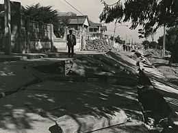
The 1985 Rapel Lake earthquake occurred on 8 April at with a moment magnitude of 7.5 and a maximum perceived intensity of VI (Strong). The shock was centered 75 kilometres (47 mi) southwest of Santiago, Chile, with a focal depth of 37.8 km (23 mi).

The 2010 Pichilemu earthquakes, also known as the Libertador O'Higgins earthquakes, were a pair of intraplate earthquakes measuring 6.9 and 7.0 that struck Chile's O'Higgins Region on 11 March 2010 about 16 minutes apart. The earthquakes were centred 15 kilometres (9.3 mi) northwest of the city of Pichilemu.
The 1982 Flores earthquake struck the island of Flores in Indonesia on December 25. Registering a moment magnitude of 5.9, according to the International Seismological Centre, it created landslides and was reportedly accompanied by a tsunami. The earthquake killed thirteen people and left 390 injured, also destroying 1,875 houses and 121 other buildings. The villages of Layahong and Oyong Barang were damaged by seven seconds of shaking.
The 1932 Jalisco earthquakes began on June 3 at 10:36 UTC with a megathrust event that registered 8.1 on the moment magnitude scale. With a maximum perceived intensity of X (Extreme) on the Mercalli intensity scale, at least 400 deaths were caused in Mexico and neighboring Guatemala. It was the first of a series of seismic events that affected parts of western Mexico during the month of June 1932, all reaching magnitude 7 or greater.

The 2013 Bushehr earthquake occurred with a moment magnitude of 6.3 on April 9 in Iran. The shock's epicenter was in the province of Bushehr, near the city of Khvormuj and the towns of Kaki and Shonbeh. At least 37 people were killed, mostly from the town of Shonbeh and villages of Shonbeh-Tasuj district, and an estimated 850 people were injured.
The 1954 Chlef earthquake struck Chlef Province in Algeria on September 9 at . The shock measured 6.7 on the moment magnitude scale and had a maximum Mercalli intensity of XI (Extreme). It destroyed Chlef, then named Orléansville, leaving over 1,243 people dead and 5,000 injured. Damage was estimated at $6 million. It was followed by multiple aftershocks. Algeria faces annual earthquakes and has undergone several changes to its earthquake building codes since its first earthquake engineering regulations from 1717.
The 1992 Murindó earthquake occurred on October 18 at 15:11 UTC with an epicenter in the Department of Chocó, northern Colombia. The shallow magnitude 7.2 earthquake struck northwest of the town of Murindó, killing ten and injured more than a hundred. Thirty-three municipalities were severely damaged.
The 1965 Valparaíso earthquake struck near the city of La Ligua in the Valparaíso Region, Chile, about 140 km from the capital Santiago on Sunday, March 28 at 12:33 p.m. (UTC−03:00). The moment magnitude Mw 7.4–7.6 temblor killed an approximate 500 people and caused damages amounting to some US$1 billion. Many of the deaths were from El Cobre, a mining location that was wiped out after a series of dam failures caused by the earthquake spilled mineral waste onto the area, burying hundreds of residents. The shock was so powerful that it could be felt throughout the country and even across the continent to the Atlantic coast of Argentina.
The 1920 Xalapa earthquake rocked the gulf coast of Mexico on January 4, causing major damage in the states of Veracruz and Puebla. The epicenter was located somewhere in mountainous region of the eastern Trans-Mexican Volcanic Belt which triggered massive mudflows and landslides which claimed anywhere between 700 and 4,000 lives. The event produced extreme ground motions reaching causing severe ground effects. The epicentral region of this earthquake was allocated XI (Extreme) on the Modified Mercalli intensity scale. It would remain the deadliest earthquake in Mexico until the 1985 Mexico City earthquake.
The 1995 Menglian earthquake or 1995 Myanmar–China earthquake occurred on 12 July at 05:46:43 local time in the Myanmar–China border region. The earthquake had an epicenter on the Myanmar side of the border, located in the mountainous region of Shan State. It registered 7.3 on the Chinese surface wave magnitude scale (Ms ) and 6.8 on the moment magnitude scale (Mw ). With a maximum Mercalli intensity assigned at VIII, the quake killed eleven people and left another 136 injured. Over 100,000 homes in both countries were destroyed and 42,000 seriously damaged. Some damage to structures were also reported in Chiang Mai and Chiang Rai, Thailand. The low death toll from this earthquake was attributed to an early warning issued prior to it happening. Precursor events including foreshocks and some seismic anomalies led to an evacuation of the area before the mainshock struck. It is thought to be one of the few successfully predicted earthquakes in history.
The 1941 Sa'dah earthquake or the Jabal Razih earthquake occurred on January 11 in the Razih District of Yemen. The earthquake had a surface wave magnitude of 5.8–6.5 and a shallow focal depth. Despite the moderate size of this earthquake, an estimated 1,200 people perished and at least 200 injured. With a maximum MSK-64 intensity assigned at VIII, it destroyed many villages and collapsed homes in the region of North Yemen.
The 1990 Carlentini earthquake occurred off the Sicilian coast, 20 km east northeast from the town of Augusta, Sicily on 13 December at 01:24 local time. The moderately-sized earthquake measuring 5.6 on the moment magnitude scale (Mw ) resulted in the deaths of 19 people and caused at least 200 injuries. It also inflicted significant damage in the region, leaving 2,500 homeless.
The 1979 Petatlán earthquake, also known as the IBERO earthquake occurred on March 14 at 05:07 local time in the Mexican state of Guerrero. The earthquake had a surface wave magnitude of Ms 7.6 or moment magnitude of Mw 7.4 and maximum Modified Mercalli intensity of VIII (Severe). The epicenter, onshore, was located 12 km south southeast of Vallecitos de Zaragoza.
The 1915 Imperial Valley earthquakes were two destructive shocks centered near El Centro, California on June 22. The earthquakes measured 6.25 and occurred nearly one hour apart at 19:59 and 20:57 PST. Both shocks were assigned VIII (Severe) on the Modified Mercalli intensity scale. Heavy damage occurred in the areas of Mexicali and El Centro, amounting to $900,000. At least six people were killed in the earthquakes.