List of earthquakes in 1985

Last updated

Earthquakes in 1985
World location map (equirectangular 180).svg
Approximate epicenters of the earthquakes in 1985
Strongest magnitude8.1 Mw Flag of Mexico.svg Mexico
Deadliest8.1 Mw Flag of Mexico.svg Mexico
10,000+ deaths
Total fatalities10,000+
Number by magnitude
9.0+0
  1984
1986  

This is a list of earthquakes in 1985. Only earthquakes of magnitude 6 or above are included, unless they result in damage or casualties, or are notable for some other reason. All dates are listed according to UTC time.

Contents

By death toll

RankDeath tollMagnitudeLocation MMI Depth (km)Date
110,000+8.1 Flag of Mexico.svg Mexico, Michoacan offshoreIX (Violent) 20.0September 19
21778.0 Flag of Chile.svg Chile, Valparaiso offshoreVIII (Severe) 33.0March 3
3717.0 Flag of the People's Republic of China.svg China, Xinjiang VII (Very strong) 6.8August 23
4295.8 Flag of the Soviet Union.svg Soviet Union, Tajik Soviet Socialist Republic IX (Violent) 16.0August 13
5235.8 Flag of the People's Republic of China.svg China, Yunnan VII (Very strong) 5.0April 18

By magnitude

RankMagnitudeDeath tollLocation MMI Depth (km)Date
18.110,000+ Flag of Mexico.svg Mexico, Michoacan offshoreIX (Violent) 20.0September 19
18.0177 Flag of Chile.svg Chile, Valparaiso offshoreVIII (Severe) 33.0March 3
37.60 Flag of Mexico.svg Mexico, Michoacan offshoreVI (Strong) 30.8September 21
47.40 Flag of Chile.svg Chile, Valparaiso offshoreVIII (Severe) 33.0March 4
47.45 Flag of Afghanistan (1980-1987).svg Afghanistan, Badakhshan VIII (Severe) 98.7July 29
67.30 Flag of Papua New Guinea.svg Papua New Guinea, New Ireland VII (Very strong) 33.0July 3
77.21 Flag of Papua New Guinea.svg Papua New Guinea, West New Britain VIII (Severe) 26.7May 10
77.22 Flag of Chile.svg Chile, O'Higgins VI (Strong) 37.8April 9
97.10 Flag of Vanuatu.svg Vanuatu, Torba VI (Strong) 43.0December 21
97.10 Flag of Indonesia.svg Indonesia, Papua VI (Strong) 10.0November 17
117.00 Flag of Vanuatu.svg Vanuatu, Torba offshoreVI (Strong) 33.0November 28
117.00 Flag of Vanuatu.svg Vanuatu, Torba offshoreV (Moderate) 33.0November 28
117.071 Flag of the People's Republic of China.svg China, Xinjiang VII (Very strong) 6.8August 23
117.00 Flag of the Philippines.svg Philippines, Central Luzon V (Moderate) 188.4April 23
117.00 Flag of Indonesia.svg Indonesia, Molucca Sea offshoreVII (Very strong) 50.7April 13

By month

January

January
Strongest magnitude6.9 Mw Flag of Indonesia.svg  Indonesia
Deadliest6.1 Mw Flag of Argentina.svg  Argentina
6 deaths
Total fatalities6
Number by magnitude
9.0+0
8.0–8.90
7.0–7.90
6.0–6.911

February

January
Strongest magnitude6.3 Mw Flag of the Solomon Islands.svg  Solomon Islands
Deadliest5.3 Mw Flag of Iran.svg  Iran
1 death
Total fatalities1
Number by magnitude
9.0+0
8.0–8.90
7.0–7.90
6.0–6.94

March

Santa Cruz was amongst the cities damaged by the March 3 Santiago earthquake. Church of Santa Cruz pictured in 2009. Church, Santa Cruz, Chile, 2010.jpg
Santa Cruz was amongst the cities damaged by the March 3 Santiago earthquake. Church of Santa Cruz pictured in 2009.

April

May

June

July

August

Map showing the location of the epicenter of August 23 China earthquake. 1985 Wuqia earthquake.png
Map showing the location of the epicenter of August 23 China earthquake.

September

Damage provoked by the September 19 Mexico earthquake. MexCity85quake.jpg
Damage provoked by the September 19 Mexico earthquake.

October

November

December

Epicenter location of the December 23 Canada earthquake. 1985 Nahanni earthquakes.png
Epicenter location of the December 23 Canada earthquake.

Related Research Articles

<span class="mw-page-title-main">Aleutian Trench</span> An oceanic trench along the southern coastline of Alaska and the Aleutian islands

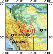
The Aleutian Trench is an oceanic trench along a convergent plate boundary which runs along the southern coastline of Alaska and the Aleutian islands. The trench extends for 3,400 kilometres (2,100 mi) from a triple junction in the west with the Ulakhan Fault and the northern end of the Kuril–Kamchatka Trench, to a junction with the northern end of the Queen Charlotte Fault system in the east. It is classified as a "marginal trench" in the east as it runs along the margin of the continent. The subduction along the trench gives rise to the Aleutian Arc, a volcanic island arc, where it runs through the open sea west of the Alaska Peninsula. As a convergent plate boundary, the trench forms part of the boundary between two tectonic plates. Here, the Pacific Plate is being subducted under the North American Plate at a dip angle of nearly 45°. The rate of closure is 7.5 centimetres (3 in) per year.

<span class="mw-page-title-main">2001 southern Peru earthquake</span> 2001 severe earthquake centered in Arequipa Region, Peru

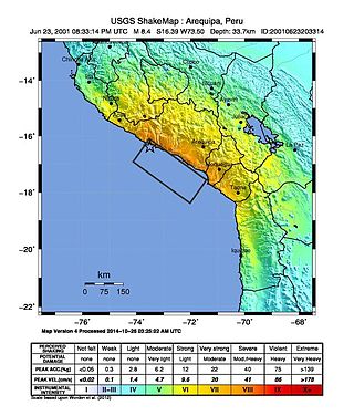
The 2001 southern Peru earthquake occurred at 20:33:15 UTC on June 23 with a moment magnitude of 8.4 and a maximum Mercalli intensity of VIII (Severe). The quake affected the Peruvian regions of Arequipa, Moquegua and Tacna. It was the most devastating earthquake in Peru since the catastrophic 1970 Ancash earthquake and globally the largest earthquake since the 1965 Rat Islands earthquake.

<span class="mw-page-title-main">2010 Chile earthquake</span> Magnitude 8.8 earthquake in Chile on 27 February 2010

The 2010 Chile earthquake and tsunami occurred off the coast of central Chile on Saturday, 27 February at 03:34 local time, having a magnitude of 8.8 on the moment magnitude scale, with intense shaking lasting for about three minutes. It was felt strongly in six Chilean regions that together make up about 80 percent of the country's population. According to the United States Geological Survey (USGS) the cities experiencing the strongest shaking—VIII (Severe) on the Mercalli intensity scale (MM)—were Concepción, Arauco, and Coronel. According to Chile's Seismological Service, Concepción experienced the strongest shaking at MM IX (Violent). The earthquake was felt in the capital Santiago at MM VII or MM VIII. Tremors were felt in many Argentine cities, including Buenos Aires, Córdoba, Mendoza, and La Rioja. Tremors were felt as far north as the city of Ica in southern Peru.

The 2014 Iquique earthquake struck off the coast of Chile on 1 April, with a moment magnitude of 8.2, at 20:46 local time. The epicenter of the earthquake was approximately 95 kilometres (59 mi) northwest of Iquique. The mainshock was preceded by a number of moderate to large shocks and was followed by a large number of moderate to very large aftershocks, including a M7.7 event on 3 April. The megathrust earthquake triggered a tsunami of up to 2.11 metres (6.9 ft) that hit Iquique at 21:05 local time. Similar-sized tsunamis were also reported to have hit the coasts of Pisagua and Arica.

The 2021 Kermadec Islands earthquakes were a series of earthquakes with magnitudes of 8.1 and 7.4 that occurred at 19:28:31 UTC on 4 March 2021. The epicentres were located southeast of Raoul Island in the Kermadec Islands, part of the New Zealand outlying islands. The main magnitude 8.1 earthquake was preceded by a magnitude 7.4 foreshock and followed by a magnitude 6.1 aftershock. A separate, unrelated magnitude 7.3 earthquake occurred off the coast of the North Island of New Zealand, approximately 900 km to the south, several hours before the main quakes. More than a dozen aftershocks exceeded magnitude 6.

<span class="mw-page-title-main">2022 Michoacán earthquake</span> 2022 earthquake in Mexico

On 19 September 2022, a moment magnitude 7.6-7.7 earthquake struck between the Mexican states of Michoacán and Colima at 13:05:06 local time. The earthquake had a depth of 26.9 km (16.7 mi), resulting in a maximum intensity of VIII (Severe) on the Modified Mercalli intensity scale. The USGS reported the epicentre was 35 km (22 mi) southwest of the town of Aquila. Two people were killed and at least 35 others were injured across several states. A magnitude 6.8 aftershock struck on 22 September, causing three more deaths.

References