List of earthquakes in 2023

Last updated

Earthquakes in 2023
World location map (equirectangular 180).svg
Green pog.svg
Green pog.svg
Green pog.svg
Green pog.svg
Green pog.svg
Green pog.svg
Green pog.svg
Green pog.svg
Green pog.svg
Green pog.svg
Green pog.svg
Green pog.svg
Green pog.svg
Green pog.svg
Green pog.svg
Green pog.svg
Green pog.svg
Green pog.svg
Green pog.svg
Green pog.svg
Green pog.svg
Green pog.svg
Green pog.svg
Green pog.svg
Green pog.svg
Green pog.svg
Green pog.svg
Green pog.svg
Green pog.svg
Green pog.svg
Green pog.svg
Green pog.svg
Green pog.svg
Green pog.svg
Green pog.svg
Green pog.svg
Green pog.svg
Green pog.svg
Green pog.svg
Green pog.svg
Green pog.svg
Green pog.svg
Green pog.svg
Green pog.svg
Green pog.svg
Green pog.svg
Green pog.svg
Green pog.svg
Green pog.svg
Green pog.svg
Green pog.svg
Green pog.svg
Green pog.svg
Green pog.svg
Green pog.svg
Green pog.svg
Green pog.svg
Green pog.svg
Green pog.svg
Green pog.svg
Green pog.svg
Green pog.svg
Green pog.svg
Green pog.svg
Green pog.svg
Green pog.svg
Green pog.svg
Green pog.svg
Green pog.svg
Green pog.svg
Green pog.svg
Green pog.svg
Green pog.svg
Green pog.svg
Green pog.svg
Green pog.svg
Green pog.svg
Green pog.svg
Green pog.svg
Green pog.svg
Green pog.svg
Green pog.svg
Green pog.svg
Green pog.svg
Green pog.svg
Green pog.svg
Green pog.svg
Green pog.svg
Green pog.svg
Green pog.svg
Green pog.svg
Green pog.svg
Green pog.svg
Green pog.svg
Green pog.svg
Green pog.svg
Green pog.svg
Green pog.svg
Green pog.svg
Green pog.svg
Green pog.svg
Green pog.svg
Green pog.svg
Green pog.svg
Green pog.svg
Green pog.svg
Green pog.svg
Green pog.svg
Green pog.svg
Green pog.svg
Green pog.svg
Green pog.svg
Yellow pog.svg
Yellow pog.svg
Yellow pog.svg
Yellow pog.svg
Yellow pog.svg
Yellow pog.svg
Yellow pog.svg
Yellow pog.svg
Yellow pog.svg
Yellow pog.svg
Yellow pog.svg
Yellow pog.svg
Yellow pog.svg
Yellow pog.svg
Yellow pog.svg
Yellow pog.svg
Yellow pog.svg
Yellow pog.svg
Yellow pog.svg
Yellow pog.svg
Yellow pog.svg
Yellow pog.svg
Yellow pog.svg
Yellow pog.svg
Yellow pog.svg
Yellow pog.svg
Yellow pog.svg
Yellow pog.svg
Yellow pog.svg
Yellow pog.svg
Yellow pog.svg
Yellow pog.svg
Yellow pog.svg
Yellow pog.svg
Yellow pog.svg
Yellow pog.svg
Yellow pog.svg
Yellow pog.svg
Yellow pog.svg
Yellow pog.svg
Yellow pog.svg
Yellow pog.svg
Yellow pog.svg
Yellow pog.svg
Yellow pog.svg
Yellow pog.svg
Yellow pog.svg
Yellow pog.svg
Yellow pog.svg
Yellow pog.svg
Yellow pog.svg
Yellow pog.svg
Yellow pog.svg
Yellow pog.svg
Yellow pog.svg
Yellow pog.svg
Yellow pog.svg
Yellow pog.svg
Yellow pog.svg
Yellow pog.svg
Yellow pog.svg
Yellow pog.svg
Yellow pog.svg
Yellow pog.svg
Yellow pog.svg
Yellow pog.svg
Yellow pog.svg
Yellow pog.svg
Yellow pog.svg
Yellow pog.svg
Yellow pog.svg
Yellow pog.svg
Yellow pog.svg
Yellow pog.svg
Yellow pog.svg
Yellow pog.svg
Yellow pog.svg
Yellow pog.svg
Yellow pog.svg
Yellow pog.svg
Yellow pog.svg
Yellow pog.svg
Yellow pog.svg
Yellow pog.svg
Yellow pog.svg
Yellow pog.svg
Yellow pog.svg
Orange pog.svg
Orange pog.svg
Orange pog.svg
Orange pog.svg
Orange pog.svg
Orange pog.svg
Orange pog.svg
Orange pog.svg
Orange pog.svg
Orange pog.svg
Orange pog.svg
Orange pog.svg
Orange pog.svg
Orange pog.svg
Orange pog.svg
Orange pog.svg
Approximate epicenters of the earthquakes in 2023
Strongest magnitude7.8 Mw Flag of Turkey.svg  Turkey
Deadliest7.8 Mw Flag of Turkey.svg  Turkey
59,488–62,013 deaths
Total fatalities64,347–66,872
Number by magnitude
9.0+0
8.0–8.90
7.0–7.919
6.0–6.9128
5.0–5.91,637
4.0–4.913,816
  2022
2024  

This is a list of earthquakes in 2023. Only earthquakes of magnitude 6 or above are included, unless they result in a significant impact due to major damage, deaths or serious injuries. All dates are listed according to UTC time. The maximum intensities are based on the Modified Mercalli intensity scale. Earthquake magnitudes are based on data from the USGS. Nineteen earthquakes ≥M7 occurred within the year, and no ≥M8 earthquakes recorded for the second consecutive year.

Contents

Up to 66,900 people died from earthquakes in 2023, the highest death toll for earthquakes since 2010. At least 59,488 people died in the Turkey–Syria doublets of February, which dominated world headlines because of its extensive devastation; the first mainshock was also the largest earthquake of the year at Mw7.8. In September, Morocco suffered its largest earthquake in centuries; the Mw6.8 shock killed nearly 3,000 people. In October, four Mw6.3 earthquakes struck Afghanistan's Herat Province, killing over 1,400 people. A moderate shock in western Nepal also killed 153 people in November. In December, another tremor in northern China killed 151; the nation's deadliest since 2014. Other deadly earthquakes occurred in Ecuador, Pakistan and the Philippines.

Compared to other years

Number of earthquakes worldwide for 2013–2023
Magnitude 2013 2014 2015 2016 2017 2018 2019 2020 2021 2022 2023
8.0–9.921101110300
7.0–7.91711181661699161119
6.0–6.9123143127131104118135111141117128
5.0–5.91,4601,5801,4131,5501,4471,6711,4841,3152,0461,6031,637
4.0–4.911,87715,81713,77713,70010,54412,78211,89712,13514,64313,70713,816
Total13,48017,55215,33615,39712,10214,58913,53013,57216,84915,43815,600
List of earthquakes in 2023
Map of earthquakes in 2023 - M 5.0 or greater (map data)

By death toll

RankDeath tollMagnitudeLocation MMI Depth (km)DateEvent
159,488–62,0137.8Flag of Turkey.svg  Turkey, Kahramanmaraş XII (Extreme)10.0February 6 2023 Turkey–Syria earthquakes
7.5X (Extreme)7.4
22,9606.8Flag of Morocco.svg  Morocco, Al Haouz IX (Violent)19.0September 8 2023 Al Haouz earthquake
31,4826.3Flag of the Taliban.svg  Afghanistan, Herat VIII (Severe)14.0October 7 2023 Herat earthquakes
41535.7Flag of Nepal.svg    Nepal, Karnali VIII (Severe)16.5November 3 2023 Nepal earthquake
51515.9Flag of the People's Republic of China.svg  China, Gansu IX (Violent)10.0December 18 2023 Jishishan earthquake
6216.5Flag of the Taliban.svg  Afghanistan, Badakhshan V (Moderate)187.6March 21 2023 Badakhshan earthquake
7186.8Flag of Ecuador.svg  Ecuador, Guayas offshoreVII (Very Strong)65.8March 18 2023 Guayas earthquake
8136.3Flag of Turkey.svg  Turkey, Hatay IX (Violent)16.0February 20 2023 Turkey–Syria earthquakes
9116.7Flag of the Philippines.svg  Philippines, Soccsksargen offshoreVIII (Severe)52.0November 17 November 2023 Mindanao earthquake

Listed are earthquakes with at least 10 dead.

By magnitude

RankMagnitudeDeath tollLocation MMI Depth (km)DateEvent
17.859,488–62,013Flag of Turkey.svg  Turkey, Kahramanmaraş XII (Extreme)10.0February 6 2023 Turkey–Syria earthquakes
27.70Flags of New Caledonia.svg  New Caledonia, Loyalty Islands offshoreIV (Light)18.0May 19-
37.63Flag of the Philippines.svg  Philippines, Caraga offshoreVII (Very Strong)40.0December 2 December 2023 Mindanao earthquake
37.60Flag of Indonesia.svg  Indonesia, Maluku offshoreVI (Strong)105.2January 9-
37.60Flag of Tonga.svg  Tonga, Niuatoputapu offshoreVI (Strong)210.1May 10-
67.5-Flag of Turkey.svg  Turkey, Kahramanmaraş X (Extreme)7.4February 6 2023 Turkey–Syria earthquakes
77.20Flag of Tonga.svg  Tonga, Tongatapu offshoreVI (Strong)167.4June 15-
77.20Flag of the United States.svg  United States, Alaska offshoreVII (Very Strong)25.0July 16-
97.10Flag of Indonesia.svg  Indonesia, North Sumatra offshoreVIII (Severe)34.0April 24-
97.10Flag of New Zealand.svg  New Zealand, Kermadec Islands offshoreVII (Very Strong)46.8April 24-
97.10Flag of Indonesia.svg  Indonesia, Banda Sea offshoreVI (Strong)10.0November 8-
97.10Flag of Vanuatu.svg  Vanuatu, Tafea offshoreVI (Strong)48.4December 7-
97.10Flags of New Caledonia.svg  New Caledonia, Loyalty Islands offshoreIV (Light)36.0May 20-
97.10Flag of Indonesia.svg  Indonesia, East Java offshoreIV (Light)513.5August 28-
157.00Flag of Vanuatu.svg  Vanuatu, Sanma offshoreVII (Very strong)29.0January 8-
157.08Flag of Papua New Guinea.svg  Papua New Guinea, East Sepik VII (Very strong)70.0April 2 2023 Papua New Guinea earthquake
157.00Flag of Indonesia.svg  Indonesia, North Maluku offshoreV (Moderate)28.6January 18-
157.01Flag of Indonesia.svg  Indonesia, East Java offshoreV (Moderate)597.0April 14-
157.00Flag of New Zealand.svg  New Zealand, Kermadec Islands offshoreIV (Light)10.0March 16-

Listed are earthquakes with at least 7.0 magnitude.

By month

January

January
Strongest magnitude7.6 Mw Flag of Indonesia.svg  Indonesia
Deadliest5.4 Mw Flag of Nepal.svg    Nepal
4 deaths
Total fatalities8
Number by magnitude
9.0+0
8.0–8.90
7.0–7.93
6.0–6.98
5.0–5.9126
4.0–4.91,248
DateCountry and locationMwDepth (km) MMI NotesCasualties
DeadInjured
1 [1] Flag of Indonesia.svg  Indonesia, Papua offshore, 9 km (5.6 mi) east southeast of Jayapura 5.530.8VThe wall of a hospital and a hotel partially collapsed and a shopping mall damaged in Jayapura. One hotel damaged in Abepura. [2] --
1 [3] Flag of the United States.svg  United States, California, 15 km (9.3 mi) southeast of Rio Dell 5.430.6VIIAftershock of the 2022 Ferndale earthquake. [4] Some houses damaged or destroyed and power outages in Humboldt County. [5] --
3 [6] Flag of New Zealand.svg  New Zealand, Waikato, 20 km (12 mi) north northwest of Matamata 5.010.0VIOver 100 homes damaged. [7] It is the largest earthquake in the area since 1972. [8] --
4 [9] Flag of Greece.svg  Greece, Central Greece offshore, 13 km (8.1 mi) east of Mantoudi 4.49.9VIOne house collapsed and several others damaged in Kontodespoti. [10] --
5 [11] Flag of the Taliban.svg  Afghanistan, Badakhshan, 45 km (28 mi) south of Jurm 6.0205.3IV---
8 [12] Flag of Vanuatu.svg  Vanuatu, Sanma offshore, 23 km (14 mi) west northwest of Port Olry 7.029.0VIIDozens of houses collapsed and some others damaged in Hog Harbour. [13] [14] --
9 [15] Flag of Indonesia.svg  Indonesia, Maluku offshore, 339 km west southwest of Tual 7.6105.0VI [16] Eleven people injured, [17] 15 houses collapsed, and 523 others sustained light to heavy damage in the Tanimbar Islands. [18] [19] [20] [21] -11
10 [22] Flag of Turkey.svg  Turkey, Çanakkale offshore, 6 km (3.7 mi) southwest of Behram 4.910.0IIIAt least 145 houses, four schools, and two hotels damaged in Lesbos, Greece. [23] --
12 [24] Flag of the Czech Republic.svg  Czech Republic, Moravian-Silesian, 2 km (1.2 mi) east northeast of Karviná 2.85.0IIIOne person killed and eleven others injured in a mine collapse near Stonava. [25] 111
15 [26] Flag of the Philippines.svg  Philippines, Eastern Visayas offshore, 10 km (6.2 mi) southeast of Bunga 4.810.0VFifteen people injured, thirteen houses collapsed and 352 others, some churches and roads damaged. [27] [28] [29] -15
15 [30] Flag of Albania.svg  Albania, Tirana, 10 km (6.2 mi) southwest of Klos 4.717.4IVAt least 180 buildings damaged in Tirana. [31] --
15 [32] Flag of Indonesia.svg  Indonesia, Aceh offshore, 40 km (25 mi) southeast of Singkil 6.137.0V---
15 [33] Flag of El Salvador.svg  El Salvador, Ahuachapán, 9 km (5.6 mi) northwest of Atiquizaya 5.210.0VIILargest in a swarm of 219 tremors affecting the area in one day. [34] Four people injured, [35] 713 houses destroyed and 415 others damaged in El Salvador. [36] At least 55 houses destroyed and 161 others damaged in Guatemala. [37] -4
16 [38] Flag of Japan.svg  Japan, Bonin Islands offshore6.3405.0III---
17 [39] Flag of Iran.svg  Iran, Mazandaran, 14 km (8.7 mi) south of Juybar 4.510.0IVThree people injured and four buildings damaged in Sari-Juybar area. [40] [41] -3
18 [42] Flag of Indonesia.svg  Indonesia, Gorontalo offshore, 61 km (38 mi) south southeast of Gorontalo 6.0152.5IVOne mosque damaged in Bone Bolango Regency. [43] --
18 [44] Flag of Indonesia.svg  Indonesia, North Maluku offshore, 153 km (95 mi) northwest of Tobelo 7.028.6VTwo houses collapsed in Morotai. [45] Eighteen homes damaged and tidal flooding in North Halmahera Regency. [46] [47] --
18 [48] Flag of Iran.svg  Iran, West Azerbaijan, 12 km (7.5 mi) south of Khoy 5.719.1VI-252
20 [49] Flag of France (lighter variant).svg  France, Guadeloupe offshore, 40 km (25 mi) west southwest of Pointe-Noire 6.1162.0IV---
20 [50] Flag of Argentina.svg  Argentina, Santiago del Estero, 24 km (15 mi) southwest of Campo Gallo 6.8596.8III---
23 [51] Flag of Indonesia.svg  Indonesia, West Java, 9 km (5.6 mi) north northeast of Sukabumi 4.511.1IV [52] Aftershock of the 2022 West Java earthquake. Ten people injured, some previously damaged homes collapsed, [53] and ten others damaged in Cianjur. [54] [55] -10
24 [56] Flag of Nepal.svg    Nepal, Sudurpashchim, 62 km (39 mi) northwest of Jumla 5.420.3VOne person killed by rockfalls, four others injured, [57] 60 homes collapsed and over 400 others, several hotels, schools, hospitals and a temple damaged in Bajura and Bajhang districts, Nepal. [58] [59] [57] Three people killed and 11 others injured [60] [61] after a building damaged by the earthquake collapsed in Lucknow, India. [62] 415
24 [63] Flag of Argentina.svg  Argentina, Santiago del Estero, 38 km (24 mi) southwest of Campo Gallo 6.4580.0IIAftershock of the 6.8 earthquake four days prior.--
25 [64] Flag of the People's Republic of China.svg  China, Sichuan, 30 km (19 mi) south of Kangding 5.44.0VI Aftershock of the 2022 Luding earthquake. [65] Some previously damaged homes destroyed, [66] and landslides in Luding County. [67] --
26 [68] Flag of New Zealand.svg  New Zealand, Kermadec Islands offshore6.0135.7IV---
27 [69] Flag of Indonesia.svg  Indonesia, West Java, 9 km (5.6 mi) northeast of Cileunyi 4.211.6-At least 49 houses damaged, [70] and some collapsed in Bandung Regency. [71] --
28 [72] Flag of Iran.svg  Iran, West Azerbaijan, 14 km (8.7 mi) southwest of Khoy 5.916.0VII31,750
30 [73] Flag of Costa Rica.svg  Costa Rica, Puntarenas, 9 km (5.6 mi) east southeast of Jacó 4.536.8IVFive houses destroyed and three others damaged due to a landslide in Jacó. [74] --

February

February
Strongest magnitude7.8 Mw Flag of Turkey.svg  Turkey
Deadliest7.8 Mw Flag of Turkey.svg  Turkey
59,488–62,013 deaths
Total fatalities59,507–62,032
Number by magnitude
9.0+0
8.0–8.90
7.0–7.92
6.0–6.912
5.0–5.9142
4.0–4.91,368
A collapsed building in Hatay, Turkey. Hatay in the 2023 Gaziantep-Kahramanmaras earthquakes 03.jpg
A collapsed building in Hatay, Turkey.
DateCountry and locationMwDepth (km) MMI NotesCasualties
DeadInjured
1 [75] Flag of the Philippines.svg  Philippines, Davao, 2 km (1.2 mi) northwest of Babag 6.019.0VIISixteen people injured; [76] eight houses collapsed, [77] 543 houses, 203 buildings, [78] including 38 schools, [79] a supermarket and hospital damaged in Montevista, New Bataan and Nabunturan. [80] Landslides also occurred. [81] -16
1 [82] Flag of Indonesia.svg  Indonesia, West Java, 24 km (15 mi) east southeast of Banjar 4.510.0IIIOne person injured; 495 houses and eight schools damaged in Garut Regency. [83] [84] [85] -1
4 [86] Flag of Iran.svg  Iran, Kermanshah, 19 km (12 mi) southwest of Sarpol-e Zahab 4.710.0VFour people injured due to panic in Qasr-e Shirin. [87] -4
6 [88] Flag of Turkey.svg  Turkey, Kahramanmaraş, 26 km (16 mi) east of Nurdağı 7.810.0XII [89] 59,488–62,013121,704
6 [90] Flag of Turkey.svg  Turkey, Gaziantep, 18 km (11 mi) east southeast of Nurdağı 6.79.8VIII
6 [91] Flag of Turkey.svg  Turkey, Kahramanmaraş, 4 km (2.5 mi) south southeast of Ekinözü 7.57.4X [92]
6 [93] Flag of Turkey.svg  Turkey, Malatya, 10 km (6.2 mi) southeast of Doğanşehir 6.020.1VII
6 [94] Flag of Turkey.svg  Turkey, Kahramanmaraş, 5 km (3.1 mi) northeast of Göksun 6.08.5VIII
7 [95] Flag of the Philippines.svg  Philippines, Bicol offshore, 20 km (12 mi) north northeast of Sabang Indan 4.810.0IVTwenty-one buildings and two houses damaged in Camarines Norte. [96] --
8 [97] Flag of Peru.svg  Peru, Huancavelica, 15 km (9.3 mi) west southwest of Vilca 3.410.0-Seventy houses and a church damaged in Huasicancha. [98] --
8 [99] Flag of Lebanon.svg  Lebanon, Baalbek-Hermel, 19 km (12 mi) east northeast of Bcharré 4.110.0IIIOne person killed and another missing after a building collapsed in Harasta, Syria. [100] [101] 1-
9 [102] Flag of Indonesia.svg  Indonesia, Papua offshore, 9 km (5.6 mi) west southwest of Abepura 5.122.0V [103] Four people killed when a restaurant collapsed, five others were injured, [104] 15 houses collapsed, 29 others, five office buildings, and several other buildings damaged in Jayapura. [105] 45
13 [106] Flag of New Zealand.svg  New Zealand, Kermadec Islands offshore6.1374.0III---
14 [107] Flag of Romania.svg  Romania, Gorj, 2 km northwest of Lelești 5.610.0VIIAt least 484 houses and two churches damaged in Gorj County; [108] [109] 19 other buildings affected in Dolj, Hunedoara and Mehedinți counties. [110] [111] Rockslides in the Defileul Jiului National Park. [112] Nineteen people injured; four from fleeing in panic or falling debris, [113] and the other 15 treated for panic attacks. [114] -19
15 [115] Flag of the Philippines.svg  Philippines, Bicol offshore, 10 km (6.2 mi) north northeast of Miaga 6.18.0VIIOne person injured, [116] eight houses collapsed and 570 structures, including an auditorium damaged. Power outages in Masbate and Ticao. [117] [118] -1
16 [119] Flag of the Taliban.svg  Afghanistan, Badakhshan, 21 km (13 mi) north northwest of Fayzabad 4.656.2IISeventy-five houses collapsed in Fayzabad, trapping one child under the rubble. [120] --
17 [121] Flag of Indonesia.svg  Indonesia, Maluku offshore, 130 km (81 mi) southwest of Tual 6.139.7V---
20 [122] Flag of Turkey.svg  Turkey, Hatay, 3 km (1.9 mi) south southwest of Uzunbağ 6.316.0IX [123] 131,062
22 [124] Flag of Nepal.svg    Nepal, Sudurpashchim, 69 km (43 mi) northwest of Jumla 4.827.3IVTwo houses and a school destroyed; two hospitals and eight homes damaged in Bichhiya. [125] --
23 [126] Flag of Tajikistan.svg  Tajikistan, Gorno-Badakhshan, 65 km (40 mi) west southwest of Murghob 6.99.0VII---
23 [127] Flag of Turkey.svg  Turkey, Adana, 13 km (8.1 mi) northeast of Saimbeyli 3.55.0-One person killed due to damage at a zinc mine in Kısacıklı. [128] 1-
23 [129] Flag of Indonesia.svg  Indonesia, North Maluku offshore, 177 km (110 mi) north of Tobelo 6.397.1V---
25 [130] Flag of Turkey.svg  Turkey, Niğde, 19 km (12 mi) east northeast of Emirgazi 5.216.5VIIMany houses and a mosque damaged in Ereğli, some of them severely. [131] --
25 [132] Flag of Japan.svg  Japan, Hokkaido offshore, 27 km (17 mi) south southeast of Akkeshi 6.055.0VOne person in Hamanaka injured after a fall. Cracked floors in supermarkets at Kushiro. [133] -1
25 [134] Flag of Papua New Guinea.svg  Papua New Guinea, West New Britain, 31 km (19 mi) east northeast of Kandrian 6.237.2VI---
27 [135] Flag of Turkey.svg  Turkey, Malatya, 8 km (5.0 mi) south southeast of Yeşilyurt 5.210.0VIIAftershock of the 2023 Turkey-Syria earthquakes. About 30 buildings collapsed, [136] two people killed, and 140 others injured. [137] 2140

March

March
Strongest magnitude7.0 Mw Flag of New Zealand.svg  New Zealand
Deadliest6.5 Mw Flag of the Taliban.svg  Afghanistan
21 deaths
Total fatalities42
Number by magnitude
9.0+0
8.0–8.90
7.0–7.91
6.0–6.910
5.0–5.9109
4.0–4.91,119
DateCountry and locationMwDepth (km) MMI NotesCasualties
DeadInjured
1 [138] Flag of Papua New Guinea.svg  Papua New Guinea, West New Britain offshore, 106 km (66 mi) northwest of Kimbe 6.6600.9II---
2 [139] Flag of Vanuatu.svg  Vanuatu, Sanma offshore, 83 km (52 mi) west southwest of Port Olry 6.517.0VI---
4 [140] Flag of New Zealand.svg  New Zealand, Kermadec Islands offshore6.9211.0V---
5 [141] Flag of the Philippines.svg  Philippines, Davao, 9 km (5.6 mi) south southeast of Bantacan 5.410.0VI Foreshock of the magnitude 5.9 earthquake on 7 March. Some houses damaged in Maragusan. In Nabunturan the ceiling of a school collapsed. Severe damage to a road located between New Bataan and Maragusan. [142] --
7 [143] Flag of the Philippines.svg  Philippines, Davao, 4 km (2.5 mi) east southeast of San Mariano 5.916.1VIISixty people were injured or fainted in panic. [144] At least 950 houses destroyed and 4,840 others damaged in the epicentral area. [144] -60
9 [145] Flag of Italy.svg  Italy, Umbria, 2 km (1.2 mi) southwest of Umbertide 4.34.4IVThirteen people injured [146] and many buildings damaged in Umbertide, including 90 percent of structures in Pierantonio. [147] Around 500 people were homeless. [148] -13
9 [149] Flag of Italy.svg  Italy, Umbria, 2 km (1.2 mi) south of Umbertide 4.510.0VII
10 [150] Flag of Colombia.svg  Colombia, Santander, 3 km (1.9 mi) northwest of Aratoca 5.4160.2IVOver 20 houses damaged in several municipalities. [151] Two houses badly affected and had to be evacuated in San Gil. [152] --
14 [153] Flag of Papua New Guinea.svg  Papua New Guinea, Madang offshore, 119 km (74 mi) east of Madang 6.3213.0IV---
16 [154] Flag of New Zealand.svg  New Zealand, Kermadec Islands offshore7.010.0IVA tsunami with heights of 11 cm (0.36 ft) was observed on Raoul Island. [155] --
18 [156] Flag of Ecuador.svg  Ecuador, Guayas offshore, 6 km (3.7 mi) north northwest of Balao 6.868.0VII18495
21 [157] Flag of the Taliban.svg  Afghanistan, Badakhshan, 40 km (25 mi) south southeast of Jurm 6.5192.0V21424
22 [158] Flag of Argentina.svg  Argentina, Jujuy, 86 km (53 mi) west southwest of El Aguilar 6.4228.0IV---
22 [159] Flag of Tajikistan.svg  Tajikistan, Sughd, 47 km (29 mi) north northwest of Navobod 5.811.6VIIThree people injured, [160] 72 houses destroyed, and 650 others damaged in six villages near the epicenter. Some barns collapsed, killing dozens of livestock. [161] [162] A school was also damaged in Leilek, Kyrgyzstan. [163] -3
24 [164] Flag of Iran.svg  Iran, West Azerbaijan, 13 km (8.1 mi) southwest of Khoy 5.611.0VIIAftershock of the 2022–23 West Azerbaijan earthquakes. At least 165 people injured, two houses collapsed and 78 others damaged in 10 villages in Khoy and Salmas. [165] -165
27 [166] Flag of the Solomon Islands.svg  Solomon Islands, Isabel offshore, 75 km (47 mi) west of Buala 6.279.0V---
28 [167] Flag of Japan.svg  Japan, Hokkaido offshore, 129 km (80 mi) east northeast of Misawa 6.137.0IV---
29 [168] Flag of Indonesia.svg  Indonesia, West Java, 16 km (9.9 mi) northeast of Sukabumi 4.010.8IV [169] One house collapsed [170] and several others damaged in Cianjur, [169] two of them due to landslides in Cugenang District. [171] --
30 [172] Flag of Chile.svg  Chile, Maule offshore, 105 km (65 mi) west southwest of Constitución 6.326.0V---
31 [173] Flag of Pakistan.svg  Pakistan, Balochistan, 29 km (18 mi) northwest of Kot Malik Barkhudhar 3.410.0VThree children killed and five injured. Two houses collapsed and several others damaged in Chaman. [174] [175] 35

April

April
Strongest magnitude7.1 Mw Flag of Indonesia.svg  Indonesia
7.1 Mw Flag of New Zealand.svg  New Zealand
Deadliest7.0 Mw Flag of Papua New Guinea.svg  Papua New Guinea
8 deaths
Total fatalities9
Number by magnitude
9.0+0
8.0–8.90
7.0–7.94
6.0–6.910
5.0–5.9116
4.0–4.91,044
DateCountry and locationMwDepth (km) MMI NotesCasualties
DeadInjured
2 [176] Flag of Papua New Guinea.svg  Papua New Guinea, East Sepik, 39 km (24 mi) east southeast of Ambunti 7.070.0VII8"many"
3 [177] Flag of Russia.svg  Russia, Kamchatka Krai, 17 km (11 mi) south southeast of Vilyuchinsk 6.5101.1VISlight damage in Petropavlovsk-Kamchatsky. [178] [179] The Mutnovskaya Power Station was temporarily shut down, causing power outages. [180] --
3 [181] Flag of Indonesia.svg  Indonesia, North Sumatra offshore, 72 km (45 mi) southwest of Padangsidempuan 6.184.0VSome houses and a government building damaged in Mandailing Natal Regency. [182] --
4 [183] Flag of the Philippines.svg  Philippines, Bicol offshore, 124 km (77 mi) east of Gigmoto 6.215.0IV---
4 [184] Flag of Panama.svg  Panama, Chiriquí offshore, 71 km (44 mi) south of Boca Chica 6.316.0VSome houses, a school and a hospital slightly damaged in the provinces of Chiriquí, Veraguas and Coclé. [185] [186] --
13 [187] Flag of Canada (Pantone).svg  Canada, British Columbia offshore, 238 km (148 mi) southwest of Port McNeill 6.07.0III---
14 [188] Flag of Indonesia.svg  Indonesia, East Java offshore, 96 km (60 mi) north of Tuban 7.0597.0V [189] One house destroyed and three others damaged in West Java and East Java provinces. [190] In Tabanan, Bali, a 5-year-old boy died after fleeing in panic. [191] 1-
18 [192] South of the Fiji Islands 6.7580.0III---
19 [193] Flag of Papua New Guinea.svg  Papua New Guinea, West New Britain, 23 km (14 mi) north northeast of Kandrian 6.340.0VI---
21 [194] Flag of Indonesia.svg  Indonesia, Southeast Sulawesi offshore, 321 km (199 mi) east of Katobu 6.24.0IV---
24 [195] Flag of New Zealand.svg  New Zealand, Kermadec Islands offshore7.146.8VIIAn 11 cm (0.36 ft) high tsunami was observed in Fishing Rock, Raoul Island. [196] --
24 [197] Flag of Indonesia.svg  Indonesia, North Sumatra offshore, 170 km (110 mi) south southeast of Teluk Dalam 7.134.0VIIIOne house collapsed [198] and another was damaged in North Sumatra Province, while another house, two hospitals and one school damaged in Mentawai Islands Regency. [199] [200] [201] [202] Power outages affected more than 89,000 homes in West Sumatra and North Sumatra provinces. [203] In Tanahbala Island, South Nias Regency, a tsunami was observed with heights of 11 cm (0.36 ft). [204] --
27 [205] Flag of Nepal.svg    Nepal, Sudurpashchim, 72 km (45 mi) northeast of Dipayal 5.110.0VIAt least 23 houses badly damaged in Bajura District. [206] --
28 [207] South of the Fiji Islands 6.0587.8IIForeshock of the 6.6 event seven seconds later.--
28 [208] South of the Fiji Islands 6.6563.0II---

May

May
Strongest magnitude7.7 Mw Flags of New Caledonia.svg  New Caledonia
Deadliest6.2 Mw Flag of Japan.svg  Japan
1 death
5.3 Mw Flag of the Taliban.svg  Afghanistan
1 death
Total fatalities2
Number by magnitude
9.0+0
8.0–8.90
7.0–7.93
6.0–6.912
5.0–5.9159
4.0–4.91,270
A collapsed house in Ishikawa, Japan. Damage of 2023 Noto earthquake swarm 01.jpg
A collapsed house in Ishikawa, Japan.
DateCountry and locationMwDepth (km) MMI NotesCasualties
DeadInjured
2 [209] Flag of the People's Republic of China.svg  China, Yunnan, 29 km (18 mi) north northeast of Baoshan 5.317.9VIITen people injured. [210] Several homes collapsed; [211] 2,805 others and a hospital damaged. Power outages occurred in Baoshan. [212] [213] [210] Rockslides at Wayao. [214] -10
4 [215] Flag of the People's Republic of China.svg  China, Sichuan, 22 km (14 mi) west southwest of Xuyong 4.829.3VIAt least 748 houses damaged. [216] --
5 [217] Flag of Japan.svg  Japan, Ishikawa offshore, 49 km (30 mi) northeast of Anamizu 6.210.0VIII149
5 [218] Flag of Japan.svg  Japan, Ishikawa, 44 km (27 mi) northeast of Anamizu 5.68.2VII Aftershock of the 2023 Noto earthquake. A landslide damaged a house and a barn collapsed in Suzu. [219] --
10 [220] Flag of Tonga.svg  Tonga, Niuatoputapu offshore, 95 km (59 mi) west northwest of Hihifo 7.6210.1VI---
10 [221] Flag of Japan.svg  Japan, Chiba offshore, 9 km (5.6 mi) west southwest of Katsuura 5.235.9VISix people injured in Chiba and three in Kanagawa. [222] [223] At least 23 buildings damaged in the epicentral area. [224] [223] -9
17 [225] Flag of Guatemala.svg  Guatemala, Quiché, 4 km (2.5 mi) south of Canillá 6.4252.0IV---
18 [226] Flag of Greece.svg  Greece, Crete, 7 km (4.3 mi) south southwest of Moires 5.19.8VISeveral houses damaged in Messara. [227] In Heraklion, the balcony and the roof of a house collapsed. [228] --
19 [229] Flags of New Caledonia.svg  New Caledonia, Loyalty Islands offshore, 339 km (211 mi) east of Vao 7.718.0IVA 61 cm (2.00 ft) tsunami observed at Lenakel, Vanuatu; 21 cm (0.69 ft) at North Cape, New Zealand; 20 cm (0.66 ft) at Port Kembla, Australia; and 19 cm (0.62 ft) at Ouinne, New Caledonia. [230] [231] Tsunami debris covered the waterfront of Ahipara, New Zealand. [232] --
20 [233] Flag of the Philippines.svg  Philippines, Mimaropa offshore, 8 km (5.0 mi) west of Libertad 4.810.0VSeveral people injured. [234] Fifteen buildings damaged and landslides occurred in Romblon. [235] One school partially collapsed and another damaged at Odiongan. [236] -Several
20 [237] Flags of New Caledonia.svg  New Caledonia, Loyalty Islands offshore, 306 km (190 mi) east of Vao 7.136.0IV Aftershock of the magnitude 7.7 earthquake on 19 May. A tsunami measured 14 cm (0.46 ft) at Ouinne. [238] --
20 [239] Flags of New Caledonia.svg  New Caledonia, Loyalty Islands offshore, 307 km (191 mi) east of Vao 6.510.0VAftershock of the magnitude 7.7 and 7.1 earthquakes on 19 and 20 May.--
21 [240] Flag of South Africa.svg  South Africa offshore, Prince Edward Islands region6.810.0----
21 [241] Flag of the Solomon Islands.svg  Solomon Islands, Makira, 55 km (34 mi) west northwest of Kirakira 6.177.8V---
22 [242] Flag of Iran.svg  Iran, East Azerbaijan, 49 km (30 mi) east of Hashtrud 4.510.0VEighteen people injured. [243] Three houses collapsed; 439 others damaged in 59 villages around Sarab and Mianeh. [244] -18
23 [245] Flags of New Caledonia.svg  New Caledonia, Loyalty Islands offshore, 288 km (179 mi) east of Vao 6.112.1VIAftershock of the magnitude 7.7 and 7.1 earthquakes on 19 and 20 May.--
24 [246] Flag of Indonesia.svg  Indonesia, Maluku offshore, 328 km (204 mi) east northeast of Lospalos, East Timor 6.2166.5IV---
25 [247] Flag of Colombia.svg  Colombia, Chocó offshore, 46 km (29 mi) northeast of Puerto Obaldía, Panama 6.513.0VITwo hotels and several homes collapsed and some others damaged in Acandí. Some houses and the municipal hall damaged in Necoclí. Ground cracks occurred in Las Changas village and Puerto Escondido. [248] [249] Items knocked from shelves in Las Minas, Panama. [250] --
26 [251] Flag of Japan.svg  Japan, Chiba offshore, 13 km (8.1 mi) southeast of Narutō 6.144.5VOne person injured in Mito. [252] Minor damage to a building in Asahi. [253] -1
26 [254] West Chile Rise 6.010.0----
27 [255] Flag of Tonga.svg  Tonga, Vavaʻu offshore, 127 km (79 mi) west of Neiafu 6.0223.9IV---
28 [256] Flag of the Taliban.svg  Afghanistan, Badakhshan, 35 km (22 mi) southeast of Jurm 5.3223.8VOne person killed in Upper Kohistan District, Pakistan. [257] Three people injured when a livestock shed collapsed in Battagram District. [258] 13
31 [259] Flag of New Zealand.svg  New Zealand, Auckland Islands offshore6.39.8II---
31 [260] Flag of Myanmar.svg  Myanmar, Kachin, 121 km (75 mi) west southwest of Myitkyina 5.910.0VIIIMany houses, buildings, schools and some pagodas damaged in Hopin. [261] Ground cracks and liquefaction occurred at Indawgyi. [262] --

June

June
Strongest magnitude7.2 Mw Flag of Tonga.svg  Tonga
Deadliest4.9 Mw Flag of Haiti.svg  Haiti
4 deaths
Total fatalities8
Number by magnitude
9.0+0
8.0–8.90
7.0–7.91
6.0–6.99
5.0–5.9121
4.0–4.91,121
DateCountry and locationMwDepth (km) MMI NotesCasualties
DeadInjured
3 [263] Flag of Peru.svg  Peru, Arequipa, 3 km (1.9 mi) south southeast of Chivay 5.410.0VIFive buildings collapsed; over 800 homes and 18 buildings damaged in Caylloma. [264] Rockslides blocked roads near the epicenter. [265] --
6 [266] Flag of Haiti.svg  Haiti, Grand'Anse offshore, 9 km (5.6 mi) northeast of Les Abricots 4.910.0VIIFour people killed and 37 others injured. [267] [268] Some homes collapsed and many damaged in Jérémie. [269] 437
6 [270] Flag of Romania.svg  Romania, Arad, 6 km (3.7 mi) southwest of Fântânele 4.75.8VII [271] Over 100 buildings damaged in Arad County. [272] --
7 [273] Flag of Myanmar.svg  Myanmar, Ayeyarwady, 20 km (12 mi) south southwest of Nyaungdon 4.810.0VIThree people killed and several others injured in Maubin. [274] [275] Some buildings destroyed; several more buildings, a school and pagoda damaged. [276] 3Several
7 [277] Flag of Bulgaria.svg  Bulgaria, Plovdiv, 3 km (1.9 mi) southeast of Asenovgrad 4.610.0VIIIn Krumovo, many brick walls and chimneys collapsed. [278] Four schools in Asenovgrad and Radovo damaged. [279] --
8 [280] Flag of Greece.svg  Greece, Central Greece, 6 km (3.7 mi) southwest of Atalanti 4.810.0VAt least 32 houses, six churches and three schools damaged at Atalanti. [281] In Exarchos, the roofs of some houses collapsed. [282] A landslide occurred in Tragána  [ el ]. [283] Subsidence at a beach in northern Evia. [284] --
10 [285] Flag of the Republic of China.svg  Taiwan, Tainan, 37 km (23 mi) south southeast of Yujing 4.926.6IVOne home collapsed in Madou District. [286] --
11 [287] Flag of South Africa.svg  South Africa, Gauteng, 6 km (3.7 mi) south southeast of Alberton 4.910.0VISome buildings damaged in Gauteng. [288] In Ekurhuleni, the ceiling of a building collapsed. [289] --
11 [290] Flag of Indonesia.svg  Indonesia, West Java, 16 km (9.9 mi) northeast of Sukabumi 3.310.0-Two people injured and two homes damaged in Bogor Regency. [291] Dozens of houses damaged in Cianjur Regency. [292] -2
11 [293] Flag of Japan.svg  Japan, Hokkaido offshore, 18 km (11 mi) west southwest of Biratori 6.2121.0VOne woman injured at Muroran. Broken windows reported in Obihiro and Abira and the ceiling of a gymnasium collapsed in Biratori. [294] -1
13 [295] Flag of India.svg  India, Jammu and Kashmir, 22 km (14 mi) northeast of Bhadarwāh 5.210.0VIISix people injured. [296] 56 buildings collapsed and 369 others damaged in Kishtwar. [297] Dozens of buildings including a hospital damaged in Bhaderwah [298] and Doda. [299] -6
15 [300] Flag of the Philippines.svg  Philippines, Calabarzon offshore, 11 km (6.8 mi) south southeast of Hukay 6.2112.0VForty-two people injured in Laguna and Batangas provinces. [301] [302] One hundred and sixteen buildings damaged throughout Calabarzon and Mimaropa regions. [302] [303] Two stations of Metro Rail Transit Line 3 affected. [304] -42
15 [305] Flag of Tonga.svg  Tonga, Tongatapu offshore, 280 km (170 mi) southwest of Houma 7.2175.0VI---
16 [306] Flag of Tonga.svg  Tonga, ʻAta offshore, 265 km (165 mi) south southwest of 'Ohonua 6.022.0- Foreshock of the magnitude 6.2 earthquake that same day.--
16 [307] Flag of France.svg  France, Nouvelle-Aquitaine, 5 km (3.1 mi) south southeast of Mauzé-sur-le-Mignon 4.85.0VITwo people injured. [308] More than 100 buildings destroyed and more than 5,000 others damaged, [309] rockslides and power outages occurred in Deux-Sèvres, [308] Charente-Maritime, [310] and Vendee departments. [311] -2
16 [312] Flag of Tonga.svg  Tonga, ʻAta offshore, 251 km (156 mi) south southwest of 'Ohonua 6.220.5----
17 [313] Flag of Tonga.svg  Tonga, ʻAta offshore, 237 km (147 mi) south southwest of 'Ohonua 6.035.0----
17 [314] Flag of Iran.svg  Iran, West Azerbaijan, 10 km (6.2 mi) south southwest of Khowy 4.510.0VThirty-five people injured in Khoy. [315] -35
18 [316] Flag of Ecuador.svg  Ecuador, Napo, 36 km (22 mi) northeast of Archidona 5.130.3VOne person injured by broken glass in Archidona. [317] -1
18 [318] Flag of Mexico.svg  Mexico, Baja California Sur offshore, 105 km (65 mi) east southeast of La Rivera 6.410.0V---
18 [319] South of Africa 6.010.0----
19 [320] Flag of Papua New Guinea.svg  Papua New Guinea, East Sepik Province, 96 km (60 mi) east southeast of Angoram 6.223.8VII---
25 [321] Flag of Tonga.svg  Tonga, ʻEua offshore, 307 km (191 mi) south southwest of 'Ohonua 6.29.0----
27 [322] Flag of Ecuador.svg  Ecuador, Esmeraldas, 5 km (3.1 mi) east of Muisne 5.035.0VIOne person injured; 20 buildings and a road damaged; power outages in Muisne. [323] [324] -1
28 [325] Flag of Thailand.svg  Thailand, Kamphaeng Phet, 26 km (16 mi) northwest of Bueng Na Rang 4.110.1VOne house partially collapsed [326] and more than 66 buildings damaged in Mueang Phichit and Bang Krathum districts. [327] [328] --
28 [329] Flag of Iran.svg  Iran, Ilam, 14 km (8.7 mi) southeast of Dehloran 4.615.5IVOne person injured in Dehloran. [330] -1
30 [331] Flag of Indonesia.svg  Indonesia, Yogyakarta offshore, 83 km (52 mi) south southwest of Srandakan 5.971.0IVOne woman died of a heart attack [332] and 23 others injured. More than 22 buildings collapsed and 696 others damaged in Central Java, East Java and the Special Region of Yogyakarta. [333] 123

July

July
Strongest magnitude7.2 Mw Flag of the United States.svg  United States
Total fatalities0
Number by magnitude
9.0+0
8.0–8.90
7.0–7.91
6.0–6.97
5.0–5.9100
4.0–4.91,008
DateCountry and locationMwDepth (km) MMI NotesCasualties
DeadInjured
2 [334] Flag of Tonga.svg  Tonga, Vavaʻu offshore, 134 km (83 mi) northwest of Neiafu 6.9225.0IV---
6 [335] Flag of Poland.svg  Poland, Lower Silesia, 2 km (1.2 mi) east southeast of Polkowice 4.52.7IVSeven people injured in the Lubin mine. [336] -7
10 [337] Flag of Antigua and Barbuda.svg  Antigua and Barbuda, Barbuda offshore, 277 km (172 mi) north northeast of Codrington 6.610.0IV---
14 [338] Flag of Mexico.svg  Mexico, Chiapas offshore, 87 km (54 mi) southwest of El Palmarcito 6.335.0IV---
15 [339] Flag of Ecuador.svg  Ecuador, Pichincha, 5 km (3.1 mi) west northwest of Oyambarillo 4.512.7IVFour people injured, nine buildings damaged and landslides in Quito. [340] -4
16 [341] Flag of the United States.svg  United States, Alaska offshore, 98 km (61 mi) south of Sand Point 7.225.0VIIA tsunami was observed with heights of 15 cm (0.49 ft) in Sand Point and King Cove. [342] --
17 [343] Flag of Argentina.svg  Argentina, Neuquén, 18 km (11 mi) southeast of Loncopué 6.6186.0VII [344] Communications disrupted in parts of Chile. [344] --
17 [345] Flag of Peru.svg  Peru, Huanuco, 15 km (9.3 mi) southeast of Tingo María 4.832.6VOne home collapsed and eight others damaged in Pillco Marca District. [346] --
19 [347] Flag of El Salvador.svg  El Salvador, La Unión offshore, 43 km (27 mi) south of Intipucá 6.569.7VITwo people injured. [348] [349] At least 13 buildings including a hospital damaged in the departments of San Miguel, Usulután and Sonsonate. [350] Electricity and telephone lines disrupted. [351] Landslides occurred in several areas, including one which blocked a portion of the Pan-American Highway. [352] -2
20 [353] Flag of India.svg  India, Rajasthan, 11 km (6.8 mi) east southeast of Jaipur 4.310.0VIIAt least 15 people injured [354] and minor damage in Jaipur. [355] -15
24 [356] South of the Fiji Islands 6.0546.0II---
24 [357] Flag of Chile.svg  Chile, O'Higgins, 25 km (16 mi) east northeast of Machalí 4.31.4-At least 17 people injured due to a mine collapse at the El Teniente mine. [358] -17
25 [359] Flag of Turkey.svg  Turkey, Adana, 18 km (11 mi) northeast of Kozan 5.511.6VI Aftershock of the 2023 Turkey–Syria earthquakes. At least 63 people injured in Adana and Osmaniye Provinces; at least eight hospitalized. [360] [361] One home collapsed; 18 buildings damaged in Kozan. [362] One home damaged by rockfalls in Sumbas. [363] -63
26 [364] Flag of Vanuatu.svg  Vanuatu, Penama offshore, 95 km (59 mi) east northeast of Port Olry 6.413.0VISome homes damaged by landslides in Merelava. [365] --
30 [366] Flag of Colombia.svg  Colombia, Antioquia offshore, 28 km (17 mi) northwest of Arboletes 5.356.3VIIOne homes collapsed in Puerto Escondido. [367] --

August

August
Strongest magnitude7.1 Mw Flag of Indonesia.svg  Indonesia
Deadliest6.1 Mw Flag of Colombia.svg  Colombia
2 deaths
Total fatalities2
Number by magnitude
9.0+0
8.0–8.90
7.0–7.91
6.0–6.98
5.0–5.997
4.0–4.9991
DateCountry and locationMwDepth (km) MMI NotesCasualties
DeadInjured
1 [368] Flag of Eritrea.svg  Eritrea, Debub, 43 km (27 mi) north northeast of Adi Keyh 5.610.0VIIFive homes collapsed in Senafe. [369] --
4 [370] Flag of Indonesia.svg  Indonesia, Riau, 59 km (37 mi) north northeast of Sijunjung 4.310.0-One house collapsed [371] and more than 51 others, a hospital, and a school damaged in Kuantan Singingi Regency. [372] --
5 [373] Flag of Argentina.svg  Argentina, Santiago del Estero, 39 km (24 mi) southeast of Suncho Corral 6.2597.7II---
5 [374] Flag of the People's Republic of China.svg  China, Shandong, 26 km (16 mi) south of Dezhou 5.410.0VIITwenty-four people injured [375] and 213 buildings damaged in the Dezhou-Liaocheng area. [376] -24
5 [377] Flag of Australia (converted).svg  Australia, Western Australia, 69 km (43 mi) east of Katanning 5.210.0VIIOne building destroyed [378] and another damaged in Gnowangerup. [379] --
6 [380] Flag of Indonesia.svg  Indonesia, Central Sulawesi, 48 km (30 mi) east southeast of Palu 5.310.0VOne person injured, 14 homes destroyed, at least 281 others, three schools and two churches damaged [381] and landslides in Sigi Regency. [382] -1
9 [383] Flag of Tonga.svg  Tonga, Niuas offshore, 108 km (67 mi) northeast of Hihifo 6.142.0IV---
10 [384] Flag of Turkey.svg  Turkey, Malatya, 3 km (1.9 mi) southwest of Yeşilyurt 5.210.0VI Aftershock of the 2023 Turkey–Syria earthquakes. At least 22 people injured in Malatya and one injured in Adıyaman. [385] One building collapsed and two heavily damaged in Malatya. [386] -23
13 [387] Flag of Greece.svg  Greece, Crete, 17 km (11 mi) east northeast of Palaióchora 5.110.0IVOne person injured by rockfalls while hiking at the Samariá Gorge. [388] -1
14 [389] Flag of South Africa.svg  South Africa offshore, Prince Edward Islands region6.010.0----
14 [390] Flag of the Northern Mariana Islands.svg  Northern Mariana Islands, Tinian offshore, 271 km (168 mi) southeast of San Jose Village 6.110.0III---
15 [391] Flag of India.svg  India, Rajasthan, 19 km (12 mi) east northeast of Gulabpura 3.610.0-One home collapsed and many others damaged in Bhinai. [392] --
16 [393] Flag of Turkmenistan.svg  Turkmenistan, Balkan, 30 km (19 mi) north northeast of Türkmenbaşy 5.153.6IVTwenty buildings severely damaged in Gyzylsuw; some buildings damaged in Türkmenbaşy. [394] --
16 [395] Flag of Vanuatu.svg  Vanuatu, Torba offshore, 42 km (26 mi) west of Sola 6.5193.0IV---
17 [396] Flag of Indonesia.svg  Indonesia, West Java offshore, 124 km (77 mi) west southwest of Palabuhanratu 5.454.8IVOne person injured by falling bricks and three homes damaged in Bogor Regency. [397] One house destroyed in West Bandung Regency. [398] -1
17 [399] central Mid-Atlantic Ridge 6.010.0----
17 [400] Flag of Colombia.svg  Colombia, Meta, 10 km (6.2 mi) north northwest of Restrepo 6.110.0VII250
17 [401] Flag of Colombia.svg  Colombia, Meta, 2 km (1.2 mi) east of Restrepo 5.610.0VIII
18 [402] Flag of Iran.svg  Iran, Fars, 29 km (18 mi) northwest of Gerash 4.810.0VIISixteen people injured and more than 300 homes damaged or destroyed in Evaz. [403] -16
22 [404] Flag of Azerbaijan.svg  Azerbaijan, Masally, 4 km (2.5 mi) east southeast of Masally 4.855.2VOne home destroyed and several damaged in Masallı. [405] --
23 [406] Flag of the People's Republic of China.svg  China, Liaoning, 15 km (9.3 mi) east of Pulandian 4.710.0VOne home destroyed and 15 damaged in Pulandian. [407] --
23 [408] Flag of Argentina.svg  Argentina, Santiago del Estero, 16 km (9.9 mi) southeast of El Hoyo 6.2568.8II---
24 [409] Flag of Turkey.svg  Turkey, Malatya, 11 km (6.8 mi) southwest of Yeşilyurt 4.810.0VAftershock of the 2023 Turkey–Syria earthquakes. One person injured and one building damaged in Malatya. [410] -1
25 [411] Flag of the Philippines.svg  Philippines, Soccsksargen, 4 km (2.5 mi) east northeast of Lake Sebu 5.015.0VIOne person injured, one bridge destroyed, two homes, the municipal hall, and some roads damaged and landslides in T'Boli. [412] [413] [414] -1
28 [415] Flag of Indonesia.svg  Indonesia, East Java offshore, 171 km (106 mi) east northeast of Gili Air 7.1513.5IV---
29 [416] Flag of Turkey.svg  Turkey, Konya, 19 km (12 mi) southwest of Kulu 4.86.5IVOne chimney collapsed; one home, a mosque and three schools damaged in Kulu. [417] [418] --
31 [419] Flag of Angola.svg  Angola, Bié, 109 km (68 mi) south of Cuíto 4.310.0IVThree people injured in Cuíto. [420] -3

September

September
Strongest magnitude6.8 Mw Flag of Morocco.svg  Morocco
Deadliest6.8 Mw Flag of Morocco.svg  Morocco
2,960 deaths
Total fatalities2,961
Number by magnitude
9.0+0
8.0–8.90
7.0–7.90
6.0–6.911
5.0–5.9106
4.0–4.9994
Destroyed house in Marrakesh, Morocco. Damages in Marrakesh 1.jpg
Destroyed house in Marrakesh, Morocco.
DateCountry and locationMwDepth (km) MMI NotesCasualties
DeadInjured
1 [421] Flag of Russia.svg  Russia, Kuril Islands offshore, 11 km (6.8 mi) east northeast of Severo-Kurilsk 6.1146.0IV---
3 [422] Flag of Azerbaijan.svg  Azerbaijan, Central Aran, 7 km (4.3 mi) east southeast of Kurdamir 4.968.3VISome buildings destroyed and 100 others damaged in Kurdamir District. [423] --
4 [424] Flag of Iran.svg  Iran, Bushehr, 87 km (54 mi) west northwest of Mohr 4.310.0-Four people injured in Bandar-e Deyr. [425] -4
5 [426] Flag of the Republic of China.svg  Taiwan, Chiayi, 15 km (9.3 mi) west northwest of Pizitou 4.911.7VOne home destroyed in Minxiong; two schools destroyed and eight others damaged in Xingang. [427] [428] --
6 [429] Flag of the Philippines.svg  Philippines, Davao, 4 km (2.5 mi) east-southeast of Bato 4.910.6IVAt least 125 people injured due to panic. Three homes severely damaged and eight others and five schools damaged in Davao City. [430] -125
6 [431] Flag of Chile.svg  Chile, Coquimbo offshore, 38 km (24 mi) south southwest of Coquimbo 6.336.0VISome buildings and a factory damaged and power outages in Coquimbo. [432] --
8 [433] Flag of New Zealand.svg  New Zealand, south of the Kermadec Islands 6.689.8VI---
8 [434] Flag of Argentina.svg  Argentina, Neuquén, 2 km (1.2 mi) southwest of Cutral Có 4.210.0-Some homes collapsed, some others damaged and rockfalls in Sauzal Bonito. [435] --
8 [436] Flag of Morocco.svg  Morocco, Al Haouz, 56 km (35 mi) west of Oukaïmedene 6.819.0IX2,9605,674
9 [437] Flag of Indonesia.svg  Indonesia, Central Sulawesi offshore, 101 km (63 mi) north of Palu 6.09.9VIIThree homes damaged in Donggala Regency. [438] --
11 [439] Flag of Indonesia.svg  Indonesia, North Maluku, 38 km (24 mi) north northeast of Ternate 6.0162.5IVOne building destroyed in Manado. [440] --
11 [441] Flag of Indonesia.svg  Indonesia, West Java, 21 km (13 mi) northeast of Sukabumi 3.110.0-The walls of several homes collapsed in Cianjur Regency. [442] --
12 [443] Flag of the Philippines.svg  Philippines, Cagayan Valley offshore, 69 km (43 mi) north of Namuac 6.231.1VIFive people injured, two homes destroyed and three schools damaged in Calayan. [444] [445] -5
13 [446] Flag of Chile.svg West Chile Rise 6.110.0----
13 [447] Flag of Morocco.svg  Morocco, Al Haouz, 58 km (36 mi) west northwest of Oukaïmedene 4.210.0-Aftershock of the 2023 Al Haouz earthquake. [448] One person injured by rockfalls in Imi N'Tala. [449] -1
18 [450] Flag of Italy.svg  Italy, Tuscany, 5 km (3.1 mi) southeast of Marradi 5.110.0VIOne person killed in Modigliana and another injured in Tredozio. [451] [452] Six buildings severely damaged and many others affected in Portico e San Benedetto, Rocca San Casciano, Marradi and Tredozio. [453] 11
18 [454] Flag of Japan.svg  Japan, Okinawa offshore, 181 km (112 mi) north of Hirara 6.3183.5IV---
21 [455] Flag of Vanuatu.svg  Vanuatu, Torba offshore, 41 km (25 mi) west southwest of Sola 6.1188.4IV---
23 [456] Flag of Myanmar.svg  Myanmar, Yangon, 39 km (24 mi) north of Yangon 4.810.0VOne building destroyed in Bago; one building destroyed and two damaged in Hmawbi. [457] --
24 [458] Flag of Rwanda.svg  Rwanda, Southern, 11 km (6.8 mi) north of Nzega 4.510.0VTwo people injured; 11 homes and two schools affected in Karongi District. [459] -2
24 [460] Flag of Peru.svg  Peru, Ayacucho, 20 km (12 mi) southwest of Ayna 4.310.0IIIOne person injured by rockfalls in Huamanguilla District and one building damaged in Uchuraccay. [461] -1
28 [462] Flag of Vanuatu.svg  Vanuatu, Penama offshore, 60 km (37 mi) east of Luganville 6.1127.5IV---

October

October
Strongest magnitude6.9 Mw Flag of Papua New Guinea.svg  Papua New Guinea
Deadliest6.3 Mw Flag of the Taliban.svg  Afghanistan
1,482 deaths
Total fatalities1,491
Number by magnitude
9.0+0
8.0–8.90
7.0–7.90
6.0–6.917
5.0–5.9162
4.0–4.91,211
Destroyed village in Herat Province, Afghanistan. 2023 Herat earthquakes damage 2.png
Destroyed village in Herat Province, Afghanistan.
DateCountry and locationMwDepth (km) MMI NotesCasualties
DeadInjured
1 [463] Flag of Indonesia.svg  Indonesia, West Java, 12 km (7.5 mi) south of Cicurug 5.3109.9IIITwo homes collapsed and another damaged in Sukabumi Regency. [464] Three homes destroyed; five others damaged in Caringin  [ id ]. [465] --
2 [466] Flag of Bosnia and Herzegovina.svg  Bosnia and Herzegovina, West Herzegovina, 3 km (1.9 mi) southwest of Grude 4.510.0VOne home severely damaged by rockfalls in Sovići and several others damaged in Grude. [467] --
2 [468] Flag of Italy.svg  Italy, Campania, 10 km (6.2 mi) west southwest of Naples 4.03.0-Dozens of buildings including a school affected in Agnano and Bagnoli. [469] [470] --
3 [471] Flag of Nepal.svg    Nepal, Sudurpashchim, 40 km (25 mi) northeast of Dipayal 5.720.1VIIOne woman killed by a landslide [472] and 27 people injured. [473] At least 1,567 houses destroyed, 5,601 others damaged, landslides and power outages in Achham, Baitadi, Bajhang and Bajura districts. [474] [475] [476] One home collapsed in Someshwar [477] and many others damaged in Pithoragarh, India. [478] 127
3 [479] Flag of Japan.svg  Japan, Izu Islands offshore6.010.0IV---
4 [480] Flag of the Philippines.svg  Philippines, Cagayan Valley offshore, 65 km (40 mi) north of Namuac 5.727.0VTwo people injured in Calayan. [481] -2
4 [482] Flag of the Philippines.svg  Philippines, Davao offshore, 66 km (41 mi) east of Sarangani 6.4121.7VThirteen people injured and 21 buildings damaged in Davao City. [483] Three buildings damaged in Malita, one home and a church damaged in Sarangani, and minor damage to stores in General Santos. Power outages in Mati. [484] [485] -13
5 [486] Flag of Japan.svg  Japan, Izu Islands offshore6.110.0IVA tsunami with a height of 30 cm (12 in) observed in Hachijō-jima. [487] --
6 [488] Flag of Japan.svg  Japan, Izu Islands offshore6.110.0IV---
7 [489] Flag of Mexico.svg  Mexico, Oaxaca, 8 km (5.0 mi) west of Cuauhtémoc 5.9108.4VMany buildings, a church, a hospital, and some historic buildings affected, landslides and power outages in Oaxaca and other areas near the epicenter. [490] [491] [492] --
7 [493] Flag of Nepal.svg    Nepal, Sudurpashchim, 38 km (24 mi) northeast of Dipayal 5.024.5VOne person injured and one home partially collapsed in Masta Rural Municipality. [494] -1
7 [495] Flag of the Taliban.svg  Afghanistan, Herat, 35 km (22 mi) north northeast of Zindah Jan 6.310.0VIII1,4822,102
7 [496] Flag of the Taliban.svg  Afghanistan, Herat, 26 km (16 mi) north northeast of Zindah Jan 6.310.0VIII
7 [497] Flag of Papua New Guinea.svg  Papua New Guinea, Madang, 56 km (35 mi) southeast of Madang 6.753.5VIOne person killed, nine others injured, [498] [499] 200 houses destroyed, [500] damage to the runway of Madang Airport, [501] power outages and an oil pipeline ruptured in Madang and Rai Coast District. [502] [501] 19
7 [503] Flag of Papua New Guinea.svg  Papua New Guinea, Madang offshore, 52 km (32 mi) southeast of Madang 6.974.0VI
9 [504] Flag of Slovakia.svg  Slovakia, Prešov, 16 km (9.9 mi) south southeast of Stropkov 5.08.3VIIILargest earthquake in the area since 1930. [505] Sixteen houses destroyed, [506] over 1,000 others damaged and power outages in Humenné, Michalovce, Girovce, and Ďapalovce. [507] [506] [508] --
10 [509] Flag of Argentina.svg  Argentina, Jujuy, 57 km (35 mi) west southwest of Abra Pampa 6.0247.3IV---
11 [510] Flag of the Taliban.svg  Afghanistan, Herat, 27 km (17 mi) north northwest of Herat 6.39.0VIII3169
11 [511] Flag of Australia (converted).svg  Australia, Macquarie Island offshore6.34.8----
12 [512] Flag of Honduras.svg  Honduras, Comayagua, 13 km (8.1 mi) north northeast of La Libertad 4.610.0VOne home in Comayagua [513] and eight others in La Libertad destroyed [514] and 38 others affected to some extent in Las Lajas. [515] --
15 [516] Flag of the Taliban.svg  Afghanistan, Herat, 30 km (19 mi) north northwest of Herat 6.36.3VIII4162
15 [517] Flag of Iran.svg  Iran, Khuzestan, 21 km (13 mi) south southwest of Ramhormoz 5.310.0VIOne school collapsed [518] and several homes damaged in Ramshir. [519] --
16 [520] Flag of the United States.svg  United States, Alaska offshore, 65 km (40 mi) north northwest of Adak 6.4187.4IV---
19 [521] Flag of Indonesia.svg  Indonesia, West Java offshore, 78 km (48 mi) south southwest of Banjar 5.259.7VOne home collapsed in Pangandaran Regency and another damaged in Garut. [522] [523] --
19 [524] Flag of Iran.svg  Iran, Fars, 40 km (25 mi) east of Kazerun 4.810.0IVSeven people injured and several homes damaged in Khaneh Zenyan. [525] [526] -7
21 [527] Flag of Australia (converted).svg  Australia, Victoria, 15 km (9.3 mi) west-northwest of Apollo Bay 4.810.0VIOne wall partially fell in Brighton [528] and two homes damaged in Colac. [529] --
22 [530] Flag of Nepal.svg    Nepal, Bagmati, 35 km (22 mi) northeast of Bharatpur 5.224.7VOne person injured in Gorkha. [531] At least 20 homes destroyed, 75 others damaged and landslides in Dhading District. [532] [533] -1
23 [534] Flag of New Zealand.svg  New Zealand, Kermadec Islands offshore6.023.1IV---
28 [535] Flag of the Taliban.svg  Afghanistan, Herat, 24 km (15 mi) north northwest of Herat 5.010.0VIPart of the 2023 Herat earthquake sequence: Thirteen people injured, [536] several previously damaged homes collapsed and minor damage in Herat. [537] [538] -13
29 [539] Flag of Vanuatu.svg  Vanuatu, Tafea offshore, 55 km (34 mi) west northwest of Isangel 6.079.9V---
30 [540] Flag of Jamaica.svg  Jamaica, Portland, 4 km (2.5 mi) west northwest of Hope Bay 5.410.0VIIForty-one people injured or hospitalized. [541] [542] One building destroyed, many others including a factory damaged and power outages in Kingston. [543] [544] [545] One building collapsed in Hope Bay. [546] [547] -41
30 [548] Flag of Cape Verde.svg  Cape Verde, Brava offshore4.84.5-One person injured and four homes damaged in Brava. [549] One home collapsed in Ribeira da Garça and several others damaged in Nova Sintra. [548] -1
31 [550] Flag of Fiji.svg  Fiji, Eastern offshore, 187 km (116 mi) east northeast of Levuka 6.5549.8III---
31 [551] Flag of Chile.svg  Chile, Atacama offshore, 81 km (50 mi) west southwest of Vallenar 6.634.0VIIOne home destroyed by rockfalls in Las Breas, six others damaged in Vallenar, minor damage in San Félix and Freirina, and power outages in La Serena. [552] [553] Some landslides in the epicentral area. [554] --

November

November
Strongest magnitude7.1 Mw Flag of Indonesia.svg  Indonesia
Deadliest5.7 Mw Flag of Nepal.svg    Nepal
153 deaths
Total fatalities165
Number by magnitude
9.0+0
8.0–8.90
7.0–7.91
6.0–6.911
5.0–5.9135
4.0–4.91,236
Collapsed house in Sarangani, Philippines. Earthquake Damage in Malapatan, Sarangani.jpg
Collapsed house in Sarangani, Philippines.
DateCountry and locationMwDepth (km) MMI NotesCasualties
DeadInjured
1 [555] Flag of Iran.svg  Iran, South Khorasan, 99 km (62 mi) south southeast of Birjand 4.710.0VOne person injured, one home destroyed and several others and some mosques damaged. [556] [557] -1
1 [558] Flag of Indonesia.svg  Indonesia, East Nusa Tenggara, 22 km (14 mi) northeast of Kupang 6.136.1VIAt least 145 structures damaged in Kupang Regency, 24 in Kupang, and one in South Central Timor Regency. [559] [560] --
3 [561] Flag of Greece.svg  Greece, Central Greece, 8 km (5.0 mi) southeast of Prokopi 5.19.9IVSeveral buildings and stores damaged in Prokopi. [562] In Mantoudi, the ceiling of a school collapsed. [563] --
3 [564] Flag of Nepal.svg    Nepal, Karnali, 46 km (29 mi) east of Dailekh 5.716.5VIII153375
6 [565] Flag of Nepal.svg    Nepal, Karnali, 37 km (23 mi) east northeast of Dailekh 5.310.0IVAftershock of the 2023 Nepal earthquake. Sixteen people injured and three houses collapsed in West Rukum and Jajarkot districts. [566] [567] -16
7 [568] Flag of Ecuador.svg  Ecuador, Cotopaxi, 7 km (4.3 mi) northwest of La Maná 5.018.9VFour people injured, several homes and a health center damaged and power outages in Valencia. Six homes damaged in La Maná. One house collapsed and several others damaged in Buena Fe. [569] [570] [571] -4
8 [572] Flag of Indonesia.svg  Indonesia, Banda Sea offshore6.710.0VI Foreshock of the magnitude 7.1 event a minute later.--
8 [573] Flag of Indonesia.svg  Indonesia, Banda Sea offshore7.110.0VIA tsunami was observed with wave heights of 39 cm (15 in) at Damar. [574] --
8 [575] Flag of Iran.svg  Iran, Ardabil, 13 km (8.1 mi) west of Bileh Savar 4.852.6IVFive people injured and minor damage in Bileh Savar. [576] [577] -5
8 [578] Flag of the United States.svg  United States, Texas, 37 km (23 mi) west southwest of Mentone 5.27.4VISome injuries in Mentone and in other areas near the epicenter. [579] -Some
8 [580] Flag of Indonesia.svg  Indonesia, Banda Sea offshore6.710.0VI Aftershock of the magnitude 7.1 event a few hours earlier.--
10 [581] Flag of the Dominican Republic.svg  Dominican Republic, Monte Cristi, 7 km (4.3 mi) west northwest of Las Matas de Santa Cruz 5.019.0VIOne store destroyed, many buildings including two schools, a hospital, several malls and a police station damaged in Villa Vásquez and Santiago. [582] [583] [584] --
10 [585] Flag of Iceland.svg  Iceland, Southern Peninsula offshore, 5 km (3.1 mi) west northwest of Grindavík 5.210.0IV--
10 [586] Flag of Iceland.svg  Iceland, Southern Peninsula offshore, 2 km (1.2 mi) north of Vogar 5.310.0VIII
10 [587] Flag of Indonesia.svg  Indonesia, Banda Sea offshore6.110.7VI Aftershock of the magnitude 7.1 event two days earlier.--
13 [588] Flag of Papua New Guinea.svg  Papua New Guinea, New Ireland offshore, 135 km (84 mi) west northwest of Rabaul 6.110.0IV---
13 [589] Flag of Iran.svg  Iran, West Azerbaijan, 24 km (15 mi) southwest of Sharur, Azerbaijan 4.317.0IVFive people injured in Showt. [590] -5
14 [591] South Indian Ocean 6.110.0----
17 [592] Flag of Myanmar.svg  Myanmar, Shan, 76 km (47 mi) southwest of Keng Tung 5.710.4VIISome homes damaged in Keng Tung. [593] One person injured, two homes, 16 hospitals, and 28 schools damaged in Chiang Rai, Chiang Mai, and Sakon Nakhon provinces, Thailand. [594] [595] [596] [597] -1
17 [598] Flag of the Philippines.svg  Philippines, Soccsksargen offshore, 26 km (16 mi) west southwest of Burias 6.752.0VIII11730
17 [599] Flag of Indonesia.svg  Indonesia, West Java offshore, 48 km (30 mi) south southwest of Banjar 4.963.3IIIOne house collapsed in Sukabumi Regency. [600] --
20 [601] Flag of Iran.svg  Iran, Sistan and Baluchistan, 19 km (12 mi) east southeast of Zahedan 4.610.0VSeventy-one people injured in Zahedan. [602] -71
21 [603] Flag of Poland.svg  Poland, Silesia, near Myslowice 1.90.7-Two people injured at a mine near Myslowice. [603] [604] -2
22 [605] Flag of Indonesia.svg  Indonesia, North Maluku offshore, 93 km (58 mi) west of Tobelo 6.0119.2VOne person died in Ternate due to panic. [606] 1-
22 [607] Flag of Vanuatu.svg  Vanuatu, Penama offshore, 96 km (60 mi) east of Port-Olry 6.713.0VIIA tsunami with a height of 3 cm (1.2 in) was recorded at Litzlitz. [608] --
24 [609] Flag of the Northern Mariana Islands.svg  Northern Mariana Islands, Maug Islands offshore6.916.0VI---
27 [610] Flag of Papua New Guinea.svg  Papua New Guinea, East Sepik offshore, 45 km (28 mi) east of Wewak 6.58.0VII---

December

December
Strongest magnitude7.6 Mw Flag of the Philippines.svg  Philippines
Deadliest5.9 Mw Flag of the People's Republic of China.svg  China
151 deaths
Total fatalities154
Number by magnitude
9.0+0
8.0–8.90
7.0–7.92
6.0–6.912
5.0–5.9256
4.0–4.91,114
Damaged PAGASA Doppler weather radar station in Hinatuan, Philippines. 2023 Earthquake Damage Hinatuan Pagasa Doppler Radar Station.jpg
Damaged PAGASA Doppler weather radar station in Hinatuan, Philippines.
Earthquake aftermath in Jishishan County, China. 2023 Jishishan Earthquake aftermath CNS screenshot.jpg
Earthquake aftermath in Jishishan County, China.
DateCountry and locationMwDepth (km) MMI NotesCasualties
DeadInjured
1 [611] Flag of the People's Republic of China.svg  China, Yunnan, 16 km (9.9 mi) west of Zhefang 5.021.4VDamage to 144 homes in Xishan Township. [612] --
2 [613] Flag of Bangladesh.svg  Bangladesh, Chittagong, 10 km (6.2 mi) east northeast of Ramganj 5.538.5VTwo-hundred people injured and one mosque damaged in Comilla. [614] [615] Ten people injured in Chandpur, [616] two others in Nangalkot, [617] another injured and one building damaged in Dhaka, [618] [619] and one house damaged in Senbagh. [620] One house destroyed and 11 others damaged in Tripura, India. [621] -213
2 [622] Flag of the Philippines.svg  Philippines, Caraga, 12 km (7.5 mi) north of Hinatuan 7.640.0VII379
2 [623] Flag of the Philippines.svg  Philippines, Caraga offshore, 40 km (25 mi) north of Hinatuan 6.435.0VIAftershocks of the 7.6 event.--
2 [624] Flag of the Philippines.svg  Philippines, Caraga offshore, 42 km (26 mi) northeast of Barcelona 6.150.6V--
2 [625] Flag of the Philippines.svg  Philippines, Caraga offshore, 47 km (29 mi) east northeast of Barcelona 6.09.0V--
2 [626] Flag of the Philippines.svg  Philippines, Caraga offshore, 62 km (39 mi) east northeast of Barcelona 6.254.9V--
3 [627] Flag of the Philippines.svg  Philippines, Caraga offshore, 43 km (27 mi) east northeast of Hinatuan 6.656.2VI--
3 [628] Flag of the Philippines.svg  Philippines, Caraga offshore, 35 km (22 mi) east northeast of Aras-asan 6.930.5VI--
4 [629] Flag of Pakistan.svg  Pakistan, Balochistan, 65 km (40 mi) south southwest of Khuzdar 5.210.0IXOne person injured and many homes severely damaged in the Khuzdar area. [630] -1
7 [631] Flag of Vanuatu.svg  Vanuatu, Tafea offshore, 123 km (76 mi) south of Isangel 7.148.4VIAn 8 cm (0.26 ft) high tsunami was observed in Lenakel. [632] --
7 [633] Flag of Indonesia.svg  Indonesia, West Java offshore, 2 km (1.2 mi) west of Pelabuhanratu 3.99.5VIFourteen homes collapsed, 256 others and six buildings damaged, and ground cracks appeared in Sukabumi and Bogor regencies. [634] [635] [636] --
7 [637] Flag of Mexico.svg  Mexico, Puebla, 8 km (5.0 mi) south southeast of Buenavista de Benito Juárez 5.751.2VOne person injured in Taxco. [638] Two buildings destroyed [639] and many others damaged in Puebla. [640] -1
11 [641] Flag of Tonga.svg  Tonga, Vava'u offshore, 158 km (98 mi) west of Neiafu 6.1238.4IV---
13 [642] Flag of Indonesia.svg  Indonesia, West Java, 14 km (8.7 mi) north northwest of Pelabuhanratu 4.510.4VTwo people injured, [643] 48 homes collapsed, 1,076 others and nine buildings damaged in the Bogor-Sukabumi area. [644] -2
15 [645] Flag of Indonesia.svg  Indonesia, Central Java, 20 km (12 mi) north northeast of Majenang 4.29.2VOne home collapsed [646] and 23 others damaged in Brebes Regency. [647] --
16 [648] Flag of Indonesia.svg  Indonesia, West Sumatra offshore, 144 km (89 mi) west northwest of Pariaman 5.052.4IVOne home destroyed by a landslide in Lima Puluh Kota Regency. [649] --
18 [650] Flag of the People's Republic of China.svg  China, Gansu, 37 km (23 mi) west northwest of Linxia Chengguanzhen 5.910.0IX [651] 151982
20 [652] Flag of Peru.svg  Peru, Arequipa, 11 km (6.8 mi) south southeast of Iray 6.293.4VSome homes collapsed, 30 others damaged, and landslides blocked roads in the Aplao area. [653] [654] --
21 [655] Flag of the United States.svg  United States, Alaska offshore, 107 km (66 mi) southeast of Adak 6.130.1IV---
22 [656] south of Africa 6.110.0----
27 [657] Flag of Indonesia.svg  Indonesia, West Java offshore, 52 km (32 mi) south southwest of Singaparna 5.171.6IIITwo buildings collapsed and one home damaged in Tasikmalaya. [658] [659] One home collapsed in Garut and another in Sukabumi. [660] [661] --
28 [662] Flag of Russia.svg  Russia, Kuril Islands offshore, 113 km (70 mi) southeast of Kuril'sk 6.523.8V---
30 [663] Flag of Indonesia.svg  Indonesia, Papua, 147 km (91 mi) west southwest of Abepura 6.339.1VI---
30 [664] Flag of Bosnia and Herzegovina.svg  Bosnia and Herzegovina, Zenica-Doboj, 9 km (5.6 mi) south southwest of Željezno Polje 4.710.5VIFive people injured, one home collapsed and many others severely damaged, landslides and power outages occurred in the Zenica-Ljubetovo area. [665] [666] [667] [668] -5
31 [669] Flag of Indonesia.svg  Indonesia, West Java, 16 km (9.9 mi) northwest of Sumedang Utara 4.811.4VEleven people injured, 81 homes collapsed and 1,441 structures damaged in the Sumedang area. [670] [671] -11

See also

Related Research Articles

<span class="mw-page-title-main">2018 West Java earthquake</span> Earthquake in Indonesia

On 23 January 2018, at 13:34:50 Western Indonesian Time, an earthquake struck the Indonesian island of Java near the regency of Lebak. The earthquake, measured 5.9 on the Mww, occurred approximately 40 kilometres south of the village of Binuangeun at a depth of 43.9 kilometres. The earthquake was categorized as a strong and shallow earthquake.

<span class="mw-page-title-main">July 2018 Lombok earthquake</span> Earthquake that occurred in July 2018 in Indonesia

A Mw 6.4 earthquake struck the island of Lombok on the morning of 29 July 2018 at a shallow depth of 14 km (8.7 mi). Widespread damage was reported in the area, and authorities confirmed that 20 people were killed in the earthquake while hundreds were injured.

<span class="mw-page-title-main">2018 East Java earthquake</span> Earthquake affecting Indonesia

On 11 October 2018, an earthquake struck off the coast of East Java, Indonesia, with the epicentre located off the coast of Situbondo Regency. The earthquake, which struck at dawn, killing four people in addition to destroying or damaging hundreds of houses, mostly on the small island of Sapudi.

On 17 March 2019, an earthquake measuring Mw  5.6 struck the island of Lombok in West Nusa Tenggara, Indonesia. The earthquake triggered a landslide, killing six and injuring nearly 200 others.

<span class="mw-page-title-main">2019 North Maluku earthquake</span> July 14, 2019, earthquake in Indonesia

The 2019 North Maluku earthquake, a shallow 7.2 magnitude earthquake, struck the island of Halmahera, North Maluku, Indonesia on 14 July 2019 at 18:10 local time with its epicentre located at South Halmahera. It struck at a shallow depth of 10 km (6.2 mi) near Labuha, a small port town located in Bacan Island. The earthquake produced a non-destructive 20 cm tsunami, which struck Labuha just minutes after the shaking started. 14 people were killed by the earthquake while 129 people were injured, and more than 50,000 people were displaced. The earthquake inflicted a total damage of Rp 238 billion.

<span class="mw-page-title-main">2019 Sunda Strait earthquake</span> 2 August 2019, earthquake in Indonesia

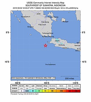
The 2019 Sunda Strait earthquake occurred on the night of 2 August 2019, when a magnitude 6.9 earthquake rattled Sunda Strait at a moderate depth of 52.8 kilometres. The epicentre was located 214 km from Bandar Lampung, the capital of Lampung and 147 km west of Sumur, Pandeglang Regency. The earthquake struck with a maximum intensity of VI (Strong). The earthquake prompted a tsunami warning in the area, with authorities urging coastal residents to immediately evacuate to higher grounds.

<span class="mw-page-title-main">2019 Ambon earthquake</span> Earthquake affecting Maluku, Indonesia

On 26 September 2019, a strong magnitude 6.5 earthquake struck Seram Island in Maluku, Indonesia, near the provincial capital of Ambon. The earthquake struck at 07:46:44 Eastern Indonesia Time with a shallow depth of 18 km. The tremor could be felt throughout the island, with an intensity of very strong (VII) reportedly felt in the provincial capital of Ambon.

A moment magnitude 6.2 earthquake struck Majene Regency in West Sulawesi, Indonesia, on 15 January 2021, at 02:28 WITA. The reverse faulting shock initiated at 18.0 km (11.2 mi) depth with an epicenter inland, located 32 km (20 mi) south of Mamuju. It was preceded by a Mw  5.7 foreshock several hours prior. Shaking from the mainshock was assigned a maximum Modified Mercalli intensity of VI (Strong) in Majene and Mamuju. Four of the five regencies in West Sulawesi were affected. More than 6,000 structures were damaged or destroyed; damage was estimated at Rp829.1 billion rupiah. At least 105 people were confirmed dead; more than 3,300 were injured and thousands were displaced.

<span class="mw-page-title-main">2021 Flores earthquake</span> Earthquake in Indonesia

An earthquake occurred 112 km, offshore, north of Maumere in the Flores Sea on 14 December. The quake had a moment magnitude of 7.3 according to the United States Geological Survey (USGS). One person was killed and 173 others suffered injuries.

<span class="mw-page-title-main">2022 Sumatra earthquake</span> Earthquake in Indonesia

On 25 February 2022 at 08:39 WIB, a moment magnitude (Mw ) 6.2 earthquake struck West Sumatra, Indonesia at a depth of 4.0 km (2.5 mi). Preceded by one foreshock and followed by over 200 aftershocks, the mainshock had an epicenter at the foot of Mount Talakmau in Pasaman Regency. The mainshock was the result of strike-slip faulting along a previously unidentified segment of the Great Sumatran Fault. At least 27 people died, 457 were injured, and 19,221 others were displaced. It inflicted 780 million Indonesian rupiahs (Rp) worth of damage. The heaviest damage was recorded at three villages around Mount Talakmau. Landslides and flash floods caused additional damage and casualties.

<span class="mw-page-title-main">2022 West Java earthquake</span> Earthquake in Indonesia

On 21 November 2022, at 13:21 WIB (UTC+07:00), a Mww 5.6 earthquake struck near Cianjur in West Java, Indonesia. The strike-slip earthquake occurred with a focal depth of 11 km (6.8 mi). Between 335 and 635 people died, 7,729 were injured and five remain missing. More than 62,628 homes were damaged across 16 districts in Cianjur Regency and the surrounding region. It is the deadliest earthquake to hit Indonesia since the 2018 Sulawesi earthquake. Damage evaluated after the event earned it a maximum Modified Mercalli intensity of VIII (Severe).

References

  1. National Earthquake Information Center (1 January 2023). "M 5.5 - 9 km ESE of Jayapura, Indonesia". United States Geological Survey. Archived from the original on 1 January 2023. Retrieved 4 January 2023.
  2. "BMKG catat 145 kali gempa susulan di Jayapura Papua". Antara (in Indonesian). 2 January 2022. Archived from the original on 4 January 2023. Retrieved 4 January 2023.
  3. National Earthquake Information Center (1 January 2023). "M 5.4 - 15km SE of Rio Dell, CA". United States Geological Survey. Archived from the original on 2 January 2023. Retrieved 2 January 2023.
  4. Hillary Andrews (2 January 2023). "Strong 5.4 aftershock wakes up northern Californians on New Year's Day". Fox News . Archived from the original on 4 January 2023. Retrieved 4 January 2023.
  5. "Earthquake: Magnitude 5.4 quake hits Northern California days after deadly temblor". The Los Angeles Times . 1 January 2023. Archived from the original on 1 January 2023. Retrieved 2 January 2023.
  6. National Earthquake Information Center (3 January 2023). "M 5.0 - 20 km NNW of Matamata, New Zealand". United States Geological Survey. Archived from the original on 3 January 2023. Retrieved 23 January 2023.
  7. "Over 100 insurance claims following north Waikato quake". Radio New Zealand . 14 January 2023. Archived from the original on 23 January 2023. Retrieved 23 January 2023.
  8. "Morning quake: Area last had strong shake in 1972". Sunlive.co.nz. 4 January 2023. Archived from the original on 26 January 2023. Retrieved 26 January 2023.
  9. National Earthquake Information Center (4 January 2023). "M 4.4 - 13 km E of Mantoúdi, Greece". United States Geological Survey. Archived from the original on 23 January 2023. Retrieved 23 January 2023.
  10. "Σεισμός στην Εύβοια: Έπεσαν παλιά κτήρια και γέμισαν τα σπίτια με ρωγμές" [Earthquake in Evia: Old buildings fell and houses were filled with cracks]. evima.gr (in Greek). 6 January 2023. Archived from the original on 23 January 2023. Retrieved 23 January 2023.
  11. National Earthquake Information Center (5 January 2023). "M 6.0 - 45 km S of Jurm, Afghanistan". United States Geological Survey. Archived from the original on 19 February 2023. Retrieved 1 February 2023.
  12. National Earthquake Information Center (8 January 2023). "M 7.0 - 23 km WNW of Port-Olry, Vanuatu". United States Geological Survey. Archived from the original on 8 January 2023. Retrieved 8 January 2023.
  13. "Se registra terremoto de magnitud 7.0 en Vanuatu; no se reportaron víctimas" [7.0 magnitude earthquake recorded in Vanuatu; no casualties were reported]. El Mañana (in Spanish). 8 January 2023. Archived from the original on 9 January 2023. Retrieved 9 January 2023.
  14. Lydia Lewis (9 January 2023). "'Earth is trembling': Vanuatu residents describe earthquake". RNZ Pacific . Archived from the original on 8 January 2023. Retrieved 8 January 2023.
  15. National Earthquake Information Center (9 January 2023). "M 7.6 - Kepulauan Tanimbar, Indonesia". United States Geological Survey. Archived from the original on 9 January 2023. Retrieved 9 January 2023.
  16. "Peta Isoseismal Gempabumi Maluku Tenggara Barat, 10 Januari 2022". BMKG (in Indonesian). 10 January 2023. Archived from the original on 10 January 2023. Retrieved 10 January 2023.
  17. "11 Orang Luka Akibat Gempa" (in Indonesian). 11 January 2023.
  18. "689 Rumah Rusak akibat Gempa M 7,5 di Maluku, Paling Banyak di Kepulauan Tanimbar" (in Indonesian). Kompas.com. 18 January 2023.
  19. "Catat! Ini Data Kerusakan Akibat Gempa M 7,9 di Tanimbar" [Note it! This is Damage Data from the M 7.9 Earthquake in Tanimbar] (in Indonesian). Maluku Terkini. 10 January 2023. Retrieved 22 March 2024.
  20. "290 Rumah di Maluku Rusak akibat Gempa M 7,5, Paling Banyak di Tanimbar" [290 houses in Maluku were damaged by the M 7.5 earthquake, mostly in Tanimbar] (in Indonesian). Kompas.com. 11 January 2023. Retrieved 22 March 2024.
  21. "Update Dampak Gempa M 7,5 Maluku: 359 Rumah Rusak, 8 Korban Luka, 400 Warga Mengungsi" [Update on the Impact of the M 7.5 Maluku Earthquake: 359 Damaged Houses, 8 Injured Victims, 400 Refugees] (in Indonesian). Kompas.com. 11 January 2023. Retrieved 22 March 2024.
  22. National Earthquake Information Center (10 January 2023). "M 4.9 - 6 km SW of Behram, Turkey". United States Geological Survey. Archived from the original on 11 January 2023. Retrieved 23 January 2023.
  23. "Λέσβος: 19 "κίτρινα" κτήρια σε 109 ελέγχους – Ζημίες και σε σχολεία". thestival.gr (in Greek). 10 January 2023. Archived from the original on 20 February 2023. Retrieved 23 January 2023.
  24. National Earthquake Information Center (12 January 2023). "M 2.8 - 2 km ENE of Karviná, Czechia". United States Geological Survey. Archived from the original on 23 February 2023. Retrieved 23 February 2023.
  25. "Při otřesu v Dole ČSM-Jih na Karvinsku zemřel horník, 11 je zraněných". České Noviny (in Czech). 12 January 2023. Archived from the original on 11 February 2023. Retrieved 11 February 2023.
  26. National Earthquake Information Center (15 January 2023). "M 4.8 - 9 km SE of Bunga, Philippines". United States Geological Survey. Archived from the original on 16 January 2023. Retrieved 16 January 2023.
  27. "Halaga ng pinsalang dulot ng lindol sa Leyte, umabot sa higit P30 milyon" (in Tagalog). 17 January 2023. Archived from the original on 17 January 2023. Retrieved 17 January 2023.
  28. "8 injured, structures damaged after quake hits Leyte". CNN Philippines . 16 January 2023. Archived from the original on 16 January 2023. Retrieved 16 January 2023.
  29. "DSWD DROMIC Report #4 on the Ms 5.3 Earthquake Incident in Leyte (Leyte) as of 26 January 2023, 6PM". Department of Social Welfare and Development (Report). ReliefWeb. 26 January 2023. Archived from the original on 29 January 2023. Retrieved 27 January 2023.
  30. National Earthquake Information Center (15 January 2023). "M 4.7 - Albania". United States Geological Survey. Archived from the original on 16 January 2023. Retrieved 23 January 2023.
  31. "Tërmeti i la në qiell të hapur; banorët e prekur nga tërmeti duan ndihmë". Vizion Plus (in Albanian). 17 January 2023. Archived from the original on 23 January 2023. Retrieved 23 January 2023.
  32. National Earthquake Information Center (15 January 2023). "M 6.1 - Nias region, Indonesia". United States Geological Survey. Archived from the original on 15 January 2023. Retrieved 15 January 2023.
  33. National Earthquake Information Center (15 January 2023). "M 5.2 - 9 km NW of Atiquizaya, El Salvador". United States Geological Survey. Archived from the original on 16 January 2023. Retrieved 16 January 2023.
  34. "Ελ Σαλβαδόρ: "Ταρακουνήθηκε" από 219 σεισμούς - Ζημιές σε τουλάχιστον 130 σπίτια" (in Greek). 17 January 2023. Archived from the original on 17 January 2023. Retrieved 17 January 2023.
  35. "Reporte de viviendas dañadas por sismos sube a 220 en Ahuachapán". EnlaMira (in Spanish). 17 January 2023. Archived from the original on 31 January 2023. Retrieved 18 January 2023.
  36. "Ahuachapán: 1,100 viviendas afectadas tras casi 15 días de sismos" (in Spanish). La Prensa Grafica. 31 January 2023. Archived from the original on 30 January 2023. Retrieved 5 February 2023.
  37. "Reporta 216 viviendas afectadas por los sismos recientes en el suroriente". La Hora (in Spanish). 18 January 2023. Archived from the original on 19 January 2023. Retrieved 19 January 2023.
  38. National Earthquake Information Center (16 January 2023). "M 6.3 - Bonin Islands, Japan region". United States Geological Survey. Archived from the original on 16 January 2023. Retrieved 16 January 2023.
  39. National Earthquake Information Center (17 January 2023). "M 4.5 - 14 km S of Jūybār, Iran". United States Geological Survey. Archived from the original on 17 January 2023. Retrieved 17 January 2023.
  40. "۴ ساختمان براثر زلزله در ساری دچار خسارت شد". Tahlilbazaar (in Persian). 17 January 2023. Archived from the original on 2 February 2023. Retrieved 18 January 2023.
  41. "مدیرکل مدیریت بحران مازندران: زلزله ۴.۲ ریشتری تاکنون خسارت جانی و مالی نداشته است". Sahebkhabar (in Persian). 17 January 2023. Archived from the original on 17 January 2023. Retrieved 17 January 2023.
  42. National Earthquake Information Center (18 January 2023). "M 6.0 - Sulawesi, Indonesia". United States Geological Survey. Archived from the original on 18 January 2023. Retrieved 18 January 2023.
  43. "Gempa Terkini M 6,3 Bone Bolango, Plafon Musala di Kecamatan Limboto Roboh". Liputan 6 (in Indonesian). 18 January 2023. Archived from the original on 19 January 2023. Retrieved 19 January 2023.
  44. National Earthquake Information Center (18 January 2023). "M 7.0 - 153 km NW of Tobelo, Indonesia". United States Geological Survey. Archived from the original on 18 January 2023. Retrieved 18 January 2023.
  45. "Gempa Merusak 2 Rumah di Morotai". HalmaheraPost.com (in Indonesian). 18 January 2023. Archived from the original on 2 February 2023. Retrieved 18 January 2023.
  46. "Kerusakan Rumah di Tobelo, Halmahera Utara Bertambah". HalmaheraPost.com (in Indonesian). 18 January 2023. Archived from the original on 2 February 2023. Retrieved 18 January 2023.
  47. "Indonesia says magnitude 7 quake off Sulawesi, residents flee buildings". Reuters. 18 January 2023. Archived from the original on 22 January 2023. Retrieved 22 January 2023.
  48. National Earthquake Information Center (18 January 2023). "M 5.7 - 12 km S of Khowy, Iran". United States Geological Survey. Archived from the original on 18 January 2023. Retrieved 18 January 2023.
  49. National Earthquake Information Center (20 January 2023). "M 6.1 - Guadeloupe region, Leeward Islands". United States Geological Survey. Archived from the original on 20 January 2023. Retrieved 20 January 2023.
  50. National Earthquake Information Center (20 January 2023). "M 6.8 - Santiago del Estero, Argentina". United States Geological Survey. Archived from the original on 20 January 2023. Retrieved 20 January 2023.
  51. National Earthquake Information Center (23 January 2023). "M 4.5 - 9 km NNE of Sukabumi, Indonesia". United States Geological Survey. Archived from the original on 23 February 2023. Retrieved 23 February 2023.
  52. "8 Orang Luka-luka Usai Gempa 4,3 Magnitudo di Cianjur". kumparan.com (in Indonesian). 24 January 2023. Archived from the original on 4 March 2023. Retrieved 24 January 2023.
  53. "Gempa M 4,3 Guncang Cianjur Dini Hari, Warga Berhamburan, Sejumlah Rumah Rusak". kompas.tv. 25 January 2023.
  54. "Increasingly, Cianjur Earthquake Injured Victims to 10 People". medcom.id. 25 January 2023. Archived from the original on 25 January 2023. Retrieved 25 January 2023.
  55. "Dampak Gempa M 4,3 Cianjur Selasa Dini Hari, 10 Rumah Rusak, Warga Dirikan Tenda Tak Berani Masuk Rumah". Kompas (in Indonesian). 24 January 2023. Archived from the original on 26 January 2023. Retrieved 26 January 2023.
  56. National Earthquake Information Center (24 January 2023). "M 5.4 - Nepal". United States Geological Survey. Archived from the original on 24 January 2023. Retrieved 24 January 2023.
  57. 1 2 "भूकम्पबाट पश्चिम नेपालका ६ जिल्लाका १५२ घर भत्किए, बुधबारसम्म पनि पराकम्प जारी". nagariknews.nagariknetwork.com. 25 January 2023. Archived from the original on 26 January 2023. Retrieved 26 January 2023.
  58. "धामीले फैलाए भूकम्पको हल्ला, नागरिक रातभर घरबाहिरै (तस्बिर)". nepalkhabar.com (in Nepali). 30 January 2023. Archived from the original on 3 February 2023. Retrieved 3 February 2023.
  59. "Quake destruction details yet to be collected". The Himalayan Times . 27 January 2023. Archived from the original on 27 January 2023. Retrieved 27 January 2023.
  60. "11 injured in a building collapse in Lucknow". The Statesman . 24 January 2023. Archived from the original on 24 January 2023. Retrieved 24 January 2023.
  61. "At least three dead, dozens feared trapped as building collapses in India". Al Arabiya English . 24 January 2023. Archived from the original on 24 January 2023. Retrieved 24 January 2023.
  62. "8 Trapped As Building Collapses In Lucknow, Had Cracks After Earthquake". NDTV . 24 January 2023. Archived from the original on 24 January 2023. Retrieved 24 January 2023.
  63. National Earthquake Information Center (24 January 2023). "M 6.4 - 33 km WSW of Campo Gallo, Argentina". United States Geological Survey. Archived from the original on 24 January 2023. Retrieved 24 January 2023.
  64. National Earthquake Information Center (25 January 2023). "M 5.4 - 30 km S of Kangding, China". United States Geological Survey. Archived from the original on 25 January 2023. Retrieved 27 January 2023.
  65. Lihui, C., ed. (26 January 2023). "四川泸定发生5.6级地震 系"9·5"泸定地震余震" [Aftershocks of the "9.5" Luding Earthquake occurred in Luding, Sichuan]. Workers' Daily (in Chinese). Archived from the original on 26 January 2023. Retrieved 26 January 2023.
  66. "【三面财经·在场】泸定县今天发生5.6级地震 磨西镇有房屋受损较为严重". China Youth Daily (in Chinese). 26 January 2023. Archived from the original on 26 January 2023. Retrieved 27 January 2023.
  67. "四川甘孜州5.6級地震:已記錄100餘次餘震 居民憶事發時晃得厲害". HK01 (in Chinese). 26 January 2023. Archived from the original on 27 January 2023. Retrieved 27 January 2023.
  68. National Earthquake Information Center (26 January 2023). "M 6.0 - Kermadec Islands, New Zealand". United States Geological Survey. Archived from the original on 26 January 2023. Retrieved 26 January 2023.
  69. National Earthquake Information Center (27 January 2023). "M 4.2 - 9 km NE of Cileunyi, Indonesia". United States Geological Survey. Archived from the original on 23 February 2023. Retrieved 23 February 2023.
  70. "2 Rumah Warga Kabupaten Bandung Rusak Imbas Gempa M 4,0". detik.com. 28 January 2023. Archived from the original on 28 January 2023. Retrieved 28 January 2023.
  71. "Kerusakan Bangunan Akibat Gempa Bandung M4.0 Dini Hari Tadi". sukabumiupdate.com. 28 January 2023. Archived from the original on 2 February 2023. Retrieved 28 January 2023.
  72. National Earthquake Information Center (28 January 2023). "M 5.9 - 14 km SW of Khoy, Iran". United States Geological Survey. Archived from the original on 28 January 2023. Retrieved 28 January 2023.
  73. National Earthquake Information Center (30 January 2023). "M 4.5 - 9 km ESE of Jacó, Costa Rica". United States Geological Survey. Archived from the original on 4 February 2023. Retrieved 4 February 2023.
  74. "Sobrepeso en casas de lujo y sismo habrían provocado deslizamiento en Punta Leona". La Teja (in Spanish). 4 February 2023. Archived from the original on 4 February 2023. Retrieved 4 February 2023.
  75. National Earthquake Information Center (1 February 2023). "M 6.0 - Mindanao, Philippines". United States Geological Survey. Archived from the original on 1 February 2023. Retrieved 1 February 2023.
  76. "16 injured in Davao de Oro earthquake". Philippine Daily Inquirer . 3 February 2023. Archived from the original on 3 February 2023. Retrieved 3 February 2023.
  77. "Kapin P3M damyos sa Compostela, DDO tungod sa linog". Radio Mindanao Network (in Cebuano). 4 February 2023. Archived from the original on 4 February 2023. Retrieved 4 February 2023.
  78. "Davao de Oro quake infrastructure damage hits P21 million –OCD". GMA News . 5 February 2023. Archived from the original on 5 February 2023. Retrieved 5 February 2023.
  79. "P68.5M needed for rehab, reconstruction of 38 schools damaged in Davao quake: DepEd". Manila Bulletin . 4 February 2023. Archived from the original on 4 February 2023. Retrieved 4 February 2023.
  80. "OCD-Davao: Initial damage from M6 earthquake at P3.4M". SunStar . 4 February 2023. Archived from the original on 4 February 2023. Retrieved 4 February 2023.
  81. "Injuries, damaged houses reported after magnitude 6 Davao de Oro quake —OCD". GMA Network . 2 February 2023. Archived from the original on 2 February 2023. Retrieved 2 February 2023.
  82. National Earthquake Information Center (1 February 2023). "M 4.5 - 22 km ESE of Banjar, Indonesia". United States Geological Survey. Archived from the original on 2 February 2023. Retrieved 2 February 2023.
  83. "495 rumah rusak akibat gempa Sesar Garsela di Garut". Antara . 3 February 2023. Archived from the original on 3 February 2023. Retrieved 3 February 2023.
  84. "Gempa Magnitudo 4,3 Guncang Garut, Puluhan Rumah di 2 Kecamatan Rusak, 1 Orang Terluka". Kompas (in Indonesian). 2 February 2023. Archived from the original on 2 February 2023. Retrieved 2 February 2023.
  85. "PVMBG team visits areas affected by 4.3M Garsela Fault quake". Antara News. 4 February 2023. Archived from the original on 4 February 2023. Retrieved 4 February 2023.
  86. National Earthquake Information Center (4 February 2023). "M 4.7 - 19 km SW of Sarpol-e Z̄ahāb, Iran". United States Geological Survey. Archived from the original on 4 February 2023. Retrieved 4 February 2023.
  87. "آمار مصدومان زلزله کرمانشاه اعلام شد". Eghtesad News. 4 February 2023. Archived from the original on 4 February 2023. Retrieved 4 February 2023.
  88. National Earthquake Information Center (6 February 2023). "M 7.8 - 26 km E of Nurdağı, Turkey". United States Geological Survey. Archived from the original on 6 February 2023. Retrieved 6 February 2023.
  89. Kandilli Observatory; Boğaziçi University (February 2023). "Kahramanmaraş - Gaziantep Türkiye M7.7 Earthquake, 6 February 2023 (04:17 GMT+03:00)" (PDF). European Mediterranean Seismological Centre . Retrieved 11 March 2023.
  90. National Earthquake Information Center (6 February 2023). "M 6.7 - 18 km ESE of Nurdağı, Turkey". United States Geological Survey. Archived from the original on 6 February 2023. Retrieved 6 February 2023.
  91. National Earthquake Information Center (6 February 2023). "M 7.5 - 4 km SSE of Ekinözü, Turkey". United States Geological Survey. Archived from the original on 6 February 2023. Retrieved 6 February 2023.
  92. AFAD (9 February 2023). "Kahramanmaraş Depremleri Değerlendirme Raporu" (PDF). Disaster and Emergency Management Presidency (in Turkish). Archived (PDF) from the original on 9 February 2023. Retrieved 10 February 2023.
  93. National Earthquake Information Center (6 February 2023). "M 6.0 - 10 km SE of Doğanşehir, Turkey". United States Geological Survey. Archived from the original on 7 February 2023. Retrieved 6 February 2023.
  94. National Earthquake Information Center (6 February 2023). "M 6.0 - Central Turkey". United States Geological Survey. Archived from the original on 6 February 2023. Retrieved 6 February 2023.
  95. National Earthquake Information Center (7 February 2023). "M 4.8 - 20 km NNE of Sabang Indan, Philippines". United States Geological Survey. Archived from the original on 16 February 2023. Retrieved 16 February 2023.
  96. "Progress Report No. 1 for Magnitude 4.6 Earthquake in Vinzons, Camarines Norte (Region V)". monitoring-dashboard.ndrrmc.gov.ph. 10 February 2023. Archived from the original on 16 February 2023. Retrieved 16 February 2023.
  97. National Earthquake Information Center (8 February 2023). "M 3.4 - 15 km WSW of Vilca, Peru". United States Geological Survey . Retrieved 8 March 2023.
  98. "Huancayo: Pobladores de Huasicancha duermen fuera de sus casas por temor a temblor". Diario Correo (in Spanish). 10 February 2023. Archived from the original on 12 February 2023. Retrieved 12 February 2023.
  99. National Earthquake Information Center (8 February 2023). "M 4.2 - 19 km ENE of Bcharré, Lebanon". United States Geological Survey. Archived from the original on 10 February 2023. Retrieved 10 February 2023.
  100. "4-storey building collapses in Syrian capital". Xinhua News Agency . 9 February 2023. Archived from the original on 11 February 2023. Retrieved 11 February 2023.
  101. "انتشال جثة مسن والبحث عن مفقود جراء انهيار مبنى حرستا". syria.news (in Arabic). 9 February 2023. Archived from the original on 10 February 2023. Retrieved 10 February 2023.
  102. National Earthquake Information Center (9 February 2023). "M 5.1 - near the north coast of Papua, Indonesia". United States Geological Survey. Archived from the original on 9 February 2023. Retrieved 9 February 2023.
  103. "Gempa Papua Jadi Momentum Peninjauan Kebijakan Bangunan Tahan Gempa" [The Papua Earthquake Becomes a Momentum for Reviewing Earthquake-Resistant Building Policies]. VOA Indonesia (in Indonesian). 12 February 2023. Archived from the original on 12 February 2023. Retrieved 12 February 2023.
  104. "Gempa di Jayapura: 700 Orang Mengungsi, 4 Tewas, 5 Luka-luka". Kompas. 9 February 2023. Archived from the original on 10 February 2023. Retrieved 10 February 2023.
  105. "BNPB: Pengungsi Gempa Papua Capai 2,136 Jiwa". Tribrata Polri. 9 February 2023. Archived from the original on 11 February 2023. Retrieved 10 February 2023.
  106. National Earthquake Information Center (13 February 2023). "M 6.1 - Kermadec Islands, New Zealand". United States Geological Survey. Archived from the original on 13 February 2023. Retrieved 13 February 2023.
  107. National Earthquake Information Center (14 February 2023). "M 5.6 - 2 km NW of Lelești, Romania". United States Geological Survey. Archived from the original on 14 February 2023. Retrieved 14 February 2023.
  108. "484 de dosare de daune, deschise în urma cutremurelor din Gorj. Câte au fost soluționate". Libertatea (in Romanian). 23 February 2023. Retrieved 5 March 2023.
  109. "Cutremur în Gorj - Peste o sută de apeluri în Gorj, în urma cutremurului de 5,7/ În urma evaluărilor vizuale, nu au fost găsite probleme majore la blocuri/ La două biserici din Târgu Jiu au fost afectate elemente ale structurii de rezistență". News.ro (in Romanian). 14 February 2023. Archived from the original on 4 March 2023. Retrieved 15 February 2023.
  110. "Cutremur în România. Arafat: Panica poate să fie Ucigătoare. Nu se dau mesaje RO-ALERT în timpul cutremurului". dcmedical.ro (in Romanian). 14 February 2023. Archived from the original on 14 February 2023. Retrieved 14 February 2023.
  111. "Cutremurul din Gorj a produs pagube în Hunedoara. Ce au reclamat localnicii după seism". Adevărul (in Romanian). 15 February 2023. Archived from the original on 16 February 2023. Retrieved 16 February 2023.
  112. "Zeci de blocuri, case și instituții publice din Gorj au fisuri după cutremur. Au căzut și stânci pe Defileul Jiului". Antena 3 CNN (in Romanian). Archived from the original on 4 March 2023. Retrieved 14 February 2023.
  113. "Cutremur puternic în România, resimțit și în București. Seismul a fost urmat de peste 15 replici. Mai multe persoane rănite și zeci de imobile afectate". Antena 3 CNN (in Romanian). 14 February 2023. Archived from the original on 4 March 2023. Retrieved 14 February 2023.
  114. "29 de apeluri la numărul de urgențe 112, după cutremur, în Hunedoara/ Aproape jumătate anunțau pagube materiale". g4media.ro (in Romanian). 14 February 2023. Archived from the original on 14 February 2023. Retrieved 14 February 2023.
  115. National Earthquake Information Center (15 February 2023). "M 6.1 - Masbate region, Philippines". United States Geological Survey. Archived from the original on 15 February 2023. Retrieved 15 February 2023.
  116. "Tingnan: Pinsala ng lindol sa Masbate". ABS-CBN News . Retrieved 16 February 2023.
  117. "Progress Report No. 5 for the Magnitude 6.0 Earthquake in Batuan, Masbate (REGION V)". National Disaster Risk Reduction and Management Council . 21 February 2023. Retrieved 24 February 2023.[ permanent dead link ]
  118. Calipay, C. (15 February 2023). "OCD-Bicol assesses magnitude 6 quake in Masbate". Philippine News Agency . Archived from the original on 16 February 2023. Retrieved 15 February 2023.
  119. National Earthquake Information Center (16 February 2023). "M 4.6 - 21 km NNW of Fayzabad, Afghanistan". United States Geological Survey . Retrieved 22 March 2023.
  120. "زلزله در بدخشان؛ طالبان می‌گویند ۷۵ خانه تخریب شده و یک کودک در زیر آوار ناپدید است". Afghanistan International. 17 February 2023. Retrieved 22 March 2023.
  121. National Earthquake Information Center (17 February 2023). "M 6.1 - 130 km SW of Tual, Indonesia". United States Geological Survey. Archived from the original on 17 February 2023. Retrieved 17 February 2023.
  122. National Earthquake Information Center (20 February 2023). "M 6.3 - 3 km SSW of Uzunbağ, Turkey". United States Geological Survey. Archived from the original on 20 February 2023. Retrieved 20 February 2023.
  123. "2023 Kahramanmaraş Ve Hatay Depremleri Raporu" (PDF). Presidency of Strategy and Budget (in Turkish). March 2023. Retrieved 23 April 2023.
  124. National Earthquake Information Center (22 February 2023). "M 4.8 - Nepal". United States Geological Survey. Archived from the original on 23 February 2023. Retrieved 23 February 2023.
  125. "School, health posts and several houses damaged due to earthquake". Nagarik . 23 February 2023. Archived from the original on 23 February 2023. Retrieved 23 February 2023.
  126. National Earthquake Information Center (23 February 2023). "M 6.9 - 65 km WSW of Murghob, Tajikistan". United States Geological Survey. Archived from the original on 23 February 2023. Retrieved 23 February 2023.
  127. European Mediterranean Seismological Centre (23 February 2023). "M 3.5 - CENTRAL TURKEY - 2023-02-23 17:37:21 UTC". European-Mediterranean Seismological Centre . Retrieved 27 March 2023.
  128. "Adana'da 3,7'lik depremin ardından madende göçük: 1 ölü". NTV (in Turkish). 23 February 2023. Retrieved 27 March 2023.
  129. National Earthquake Information Center (23 February 2023). "M 6.3 - 177 km N of Tobelo, Indonesia". United States Geological Survey. Archived from the original on 23 February 2023. Retrieved 23 February 2023.
  130. National Earthquake Information Center (25 February 2023). "M 5.2 - central Turkey". United States Geological Survey. Archived from the original on 25 February 2023. Retrieved 25 February 2023.
  131. "Son dakika... Niğde'de 5.3 büyüklüğünde deprem! Ankara, Konya ve Mersin'den de hissedildi". Hurriyet (in Turkish). 25 February 2023. Archived from the original on 25 February 2023. Retrieved 25 February 2023.
  132. National Earthquake Information Center (25 February 2023). "M 6.0 - 27 km SSE of Akkeshi, Japan". United States Geological Survey. Archived from the original on 25 February 2023. Retrieved 25 February 2023.
  133. "北海道で最大震度5弱の地震、転倒の80代女性が肩にけが...スーパーで"床割れ"の被害、エレベーターの緊急停止相次ぐ". Yahoo! News Japan (in Japanese). 26 February 2023. Archived from the original on 26 February 2023. Retrieved 26 February 2023.
  134. National Earthquake Information Center (25 February 2023). "M 6.2 - 31 km ENE of Kandrian, Papua New Guinea". United States Geological Survey. Archived from the original on 25 February 2023. Retrieved 25 February 2023.
  135. National Earthquake Information Center (27 February 2023). "M 5.2 - eastern Turkey". United States Geological Survey. Archived from the original on 27 February 2023. Retrieved 27 February 2023.
  136. "Malatya Valisi Şahin: 5.6 büyüklüğündeki deprem, psikolojik olarak insanları yıktı". Hürriyet (in Turkish). 2 March 2023. Archived from the original on 2 March 2023. Retrieved 2 March 2023.
  137. "Ölü sayısı 2 oldu" [The death toll was 2]. Busabah Malatya (in Turkish). 28 February 2023. Archived from the original on 28 February 2023. Retrieved 28 February 2023.
  138. National Earthquake Information Center (1 March 2023). "M 6.6 - 106 km NW of Kimbe, Papua New Guinea". United States Geological Survey. Archived from the original on 4 March 2023. Retrieved 1 March 2023.
  139. National Earthquake Information Center (2 March 2023). "M 6.5 - 83 km WSW of Port-Olry, Vanuatu". United States Geological Survey. Archived from the original on 2 March 2023. Retrieved 2 March 2023.
  140. National Earthquake Information Center (4 March 2023). "M 6.9 - Kermadec Islands, New Zealand". United States Geological Survey . Retrieved 4 March 2023.
  141. National Earthquake Information Center (5 March 2023). "M 5.4 - Mindanao, Philippines". United States Geological Survey . Retrieved 7 March 2023.
  142. "Two strong quakes in Davao de Oro damage highway, houses". Philippine Daily Inquirer . 5 March 2023. Retrieved 7 March 2023.
  143. National Earthquake Information Center (4 March 2023). "M 5.9 - 4 km ESE of San Mariano, Philippines". United States Geological Survey . Retrieved 4 March 2023.
  144. 1 2 "Progress Report No. 22 for the 2023 Davao de Oro Earthquake Series (REGION XI)". NDRRMC . 22 March 2023. Retrieved 23 March 2023.[ permanent dead link ]
  145. National Earthquake Information Center (9 March 2023). "M 4.3 - 2 km SW of Umbertide, Italy". United States Geological Survey . Retrieved 9 March 2023.
  146. "Tredici feriti per fughe 'da panico' durante il terremoto". ANSA (in Italian). 11 March 2023. Retrieved 13 March 2023.
  147. "Terremoto Umbertide, Pierantonio danni al 90 per cento delle abitazioni". Umbria Journal (in Italian). 12 March 2023. Retrieved 13 March 2023.
  148. "Terremoto, ipotesi 500 sfollati: Pierantonio a rischio estinzione. Tesei: "Avremo Stato d'emergenza nazionale"". Umbria24 (in Italian). 13 March 2023. Retrieved 13 March 2023.
  149. National Earthquake Information Center (9 March 2023). "M 4.5 - 2 km S of Umbertide, Italy". United States Geological Survey . Retrieved 11 March 2023.
  150. National Earthquake Information Center (10 March 2023). "M 5.4 - 3 km NW of Aratoca, Colombia". United States Geological Survey . Retrieved 11 March 2023.
  151. Stephanie Bautista Pedraza (10 March 2023). "Hubo daños en más de veinte viviendas tras el sismo en Santander: estos fueron los municipios afectados". Alerta Santanderes (in Spanish). Retrieved 11 March 2023.
  152. "Temblor en Colombia: así quedaron dos viviendas de San Gil, Santander; hubo evacuación por riesgo de colapso". Semana (in Spanish). 10 March 2023. Retrieved 11 March 2023.
  153. National Earthquake Information Center (13 March 2023). "M 6.3 - 119 km E of Madang, Papua New Guinea". United States Geological Survey . Retrieved 13 March 2023.
  154. National Earthquake Information Center (16 March 2023). "M 7.0 - Kermadec Islands region". United States Geological Survey . Retrieved 16 March 2023.
  155. National Oceanic and Atmospheric Administration (16 March 2023). "Kermadec Islands Region - Tsunami Message #3". Pacific Tsunami Warning Center . Retrieved 16 March 2023.
  156. National Earthquake Information Center (18 March 2023). "M 6.8 - 8 km NNW of Baláo, Ecuador". United States Geological Survey . Retrieved 18 March 2023.
  157. National Earthquake Information Center (21 March 2023). "M 6.5 - 40 km SSE of Jurm, Afghanistan". United States Geological Survey . Retrieved 21 March 2023.
  158. National Earthquake Information Center (22 March 2023). "M 6.4 - 86 km WSW of El Aguilar, Argentina". United States Geological Survey . Retrieved 22 March 2023.
  159. National Earthquake Information Center (22 March 2023). "M 5.8 - 47 km NNW of Novobod, Tajikistan". United States Geological Survey . Retrieved 23 March 2023.
  160. "При землетрясениях в Таджикистане пострадали три жителя сёл в эпицентре". Gazeta.uz (in Russian). 24 March 2023. Retrieved 24 March 2023.
  161. "В результате землетрясения в Таджикистане повреждены дома". Vecherka (in Russian). 23 March 2023. Retrieved 23 March 2023.
  162. "Two Earthquakes In Tajikistan Damage Hundreds Of Houses, Kill Livestock". RFE/RL's Tajik Service . 23 March 2023. Retrieved 24 March 2023.
  163. "Землетрясение силой в 5 баллов в Баткене: Последствия ощутил детсад. Видео". Turmush (in Russian). 23 March 2023. Retrieved 23 March 2023.
  164. National Earthquake Information Center (22 March 2023). "M 5.6 - 13 km SW of Khowy, Iran". United States Geological Survey . Retrieved 24 March 2023.
  165. "آخرین جزئیات زلزله خوی/ تعداد مصدومان زمین لرزه به 165 نفر رسید/ خسارت به ۸۰ واحد مسکونی". Khabarban (in Persian). 24 March 2023. Retrieved 24 March 2023.
  166. National Earthquake Information Center (27 March 2023). "M 6.2 - 75 km W of Buala, Solomon Islands". United States Geological Survey . Retrieved 27 March 2023.
  167. National Earthquake Information Center (28 March 2023). "M 6.0 - Hokkaido, Japan region". United States Geological Survey . Retrieved 28 March 2023.
  168. National Earthquake Information Center (29 March 2023). "M 4.0 - 5 km W of Sukabumi, Indonesia". United States Geological Survey . Retrieved 12 May 2023.
  169. 1 2 "Analisis Geologi Kejadian Gempa Bumi Merusak Di Kabupaten Cianjur, Provinsi Jawa Barat, Tanggal 29 Maret 2023". Ministry of Energy and Mineral Resources (in Indonesian). 30 March 2023. Archived from the original on 2 April 2023. Retrieved 2 April 2023.
  170. "Gempa Magnitudo 4,0 di Cianjur Buat Rumah Warga Rusak, Material Berhamburan". Cianjur Today (in Indonesian). 30 March 2023. Retrieved 2 April 2023.
  171. "Gempa Magnitudo 4,0 di Cianjur Merusak Rumah Warga". JPNN (in Indonesian). 29 March 2023. Retrieved 3 April 2023.
  172. National Earthquake Information Center (30 March 2023). "M 6.3 - 105 km WSW of Constitución, Chile". United States Geological Survey . Retrieved 30 March 2023.
  173. National Earthquake Information Center (31 March 2023). "M 3.4 - 29 km NW of Kot Malik Barkhurdar, Pakistan". United States Geological Survey . Retrieved 26 April 2023.
  174. "Three killed as mild earthquake hits Pakistan's Balochistan province". The Times of India . 1 April 2023. Retrieved 2 April 2023.
  175. "چمن میں زلزلے کے جھٹکے، 3 بچے جاں بحق، 5 افراد زخمی". Dawn News (in Urdu). 2 April 2023. Retrieved 2 April 2023.
  176. National Earthquake Information Center (2 April 2023). "M 7.0 - New Guinea, Papua New Guinea". United States Geological Survey . Retrieved 2 April 2023.
  177. National Earthquake Information Center (3 April 2023). "M 6.5 - near the east coast of the Kamchatka Peninsula, Russia". United States Geological Survey . Retrieved 3 April 2023.
  178. ""Это уже хорошее землетрясение": геофизики уточнили данные о сейсмособытии". kam24.ru (in Russian). 3 April 2023. Retrieved 3 April 2023.
  179. "Трещины в домах: к чему привело мощное землетрясение на Камчатке". REN TV (in Russian). 3 April 2023. Retrieved 3 April 2023.
  180. "На Камчатке из-за землетрясения отключился генератор электростанции". kam24.ru (in Russian). 3 April 2023. Retrieved 3 April 2023.
  181. National Earthquake Information Center (3 April 2023). "M 6.1 - 72 km SW of Padangsidempuan, Indonesia". United States Geological Survey . Retrieved 3 April 2023.
  182. "Dampak gempa Padang Sidimpuan, sejumlah bangunan di Madina retak-retak". Antara (in Indonesian). 3 April 2023. Retrieved 3 April 2023.
  183. National Earthquake Information Center (4 April 2023). "M 6.2 - 124 km E of Gigmoto, Philippines". United States Geological Survey . Retrieved 4 April 2023.
  184. National Earthquake Information Center (4 April 2023). "M 6.3 - 71 km S of Boca Chica, Panama". United States Geological Survey . Retrieved 4 April 2023.
  185. "Sinaproc evaluará rajaduras en algunas viviendas tras fuerte sismo". radiomiapanama.com (in Spanish). 5 April 2023. Retrieved 6 April 2023.
  186. "Continúa la evaluación de estructuras en Chiriquí tras el sismo del martes". TVN (in Spanish). 5 April 2023. Retrieved 9 April 2023.
  187. National Earthquake Information Center (13 April 2023). "M 6.0 - 238 km SW of Port McNeill, Canada". United States Geological Survey . Retrieved 13 April 2023.
  188. National Earthquake Information Center (14 April 2023). "M 7.0 - 96 km N of Tuban, Indonesia". United States Geological Survey . Retrieved 14 April 2023.
  189. "BMKG: Gempa Bumi 6,6 M di Laut Jawa Tak Berpotensi Tsunami". Kumparan (in Indonesian). 14 April 2023. Retrieved 15 April 2023.
  190. "BNPB Sebut 4 Rumah Rusak Akibat Gempa M6,6 yang Berpusat di Laut Jawa". Sindonews (in Indonesian). 15 April 2023. Retrieved 15 April 2023.
  191. "Amor Ring Acintya! Bermaksud Hindari Dampak Guncangan Gempa, Bocah 5 Tahun Meninggal". Jawa Pos (in Indonesian). 14 April 2023. Retrieved 14 April 2023.
  192. National Earthquake Information Center (18 April 2023). "M 6.7 - south of the Fiji Islands". United States Geological Survey . Retrieved 18 April 2023.
  193. National Earthquake Information Center (19 April 2023). "M 6.3 - 23 km NNE of Kandrian, Papua New Guinea". United States Geological Survey . Retrieved 19 April 2023.
  194. National Earthquake Information Center (21 April 2023). "M 6.2 - Banda Sea". United States Geological Survey . Retrieved 21 April 2023.
  195. National Earthquake Information Center (24 April 2023). "M 7.1 - Kermadec Islands, New Zealand". United States Geological Survey . Retrieved 24 April 2023.
  196. National Oceanic and Atmospheric Administration (24 April 2023). "TSUNAMI MESSAGE NUMBER 2". Pacific Tsunami Warning Center . Retrieved 24 April 2023.
  197. National Earthquake Information Center (24 April 2023). "M 7.1 - 170 km SSE of Teluk Dalam, Indonesia". United States Geological Survey . Retrieved 24 April 2023.
  198. "Gempa Sumbar Robohkan 1 Rumah Di Tapsel". Waspada (in Indonesian). 25 April 2023. Retrieved 25 April 2023.
  199. "Dua Rumah Rusak dan 8.137 Jiwa Mengungsi akibat Gempa M6,9 Mentawai" [Two Damaged Houses and 8,137 People Displaced as a result of the M6.9 Mentawai Earthquake]. cakaplah.com (in Indonesian). 25 April 2023. Retrieved 25 April 2023.
  200. "BPBD: Tidak Ada Korban Jiwa dalam Gempa Magnitudo 6,9 di Kepulauan Mentawai". Merdeka.com (in Indonesian). 25 April 2023. Retrieved 25 April 2023.
  201. "Quake damages hospital, sends Indonesians racing to highland". ABC News . 25 April 2023. Retrieved 25 April 2023.
  202. "Pasca Gempa, Camat Siberut Barat: Tidak Ada Kerusakan Rumah Warga, Puskesmas Simatalu Sedikit Retak". Tribun Network (in Indonesian). 26 April 2023. Retrieved 26 April 2023.
  203. Ade Hapsari Lestarini (25 April 2023). "PLN Klaim Listrik di Sumbar Kembali Pulih Kurang dari 2 Jam Pascagempa Mentawai". Medcom (in Indonesian). Retrieved 25 April 2023.
  204. Antara (24 April 2023). "BMKG Catat Tsunami 11 Cm di Nias Selatan Usai Gempa Mentawai M 6,9". Detik.com . Retrieved 24 April 2023.
  205. National Earthquake Information Center (27 April 2023). "M 5.1 - 71 km NE of Dipayal, Nepal". United States Geological Survey . Retrieved 29 April 2023.
  206. "गएरातिको भूकम्पले २३ घरमा क्षति". reportersnepal.com (in Nepali). 28 April 2023. Retrieved 28 April 2023.
  207. National Earthquake Information Center (28 April 2023). "M 6.0 - south of the Fiji Islands". United States Geological Survey . Retrieved 28 April 2023.
  208. National Earthquake Information Center (28 April 2023). "M 6.6 - south of the Fiji Islands". United States Geological Survey . Retrieved 28 April 2023.
  209. National Earthquake Information Center (2 May 2023). "M 5.3 - 29 km NNE of Bonan, China". United States Geological Survey . Retrieved 2 May 2023.
  210. 1 2 "云南隆阳5.2级地震,已造成10人轻伤". Singtao News Network (in Chinese). 2 May 2023. Retrieved 2 May 2023.
  211. "云南保山发生5.2级地震,官方:出现房屋倒塌,有受困人员被救". Sohu (in Chinese). 2 May 2023. Retrieved 2 May 2023.
  212. "3 injured in 5.2-magnitude earthquake in Southwest China's Yunnan". chinadaily.com.cn. 3 May 2023. Retrieved 3 May 2023.
  213. "云南隆阳连续发生地震,有医院墙体开裂 大理消防:已做好跨区增援准备". Sina (in Chinese). 2 May 2023. Retrieved 2 May 2023.
  214. "云南保山5.2级地震3人轻伤,已转移群众11090人,震中瓦窑镇部分房屋有裂痕". Sina (in Chinese). 2 May 2023. Retrieved 2 May 2023.
  215. National Earthquake Information Center (4 May 2023). "M 5.0 - 19 km WSW of Xuyong, China". United States Geological Survey . Retrieved 4 May 2023.
  216. "四川兴文县地震:748间房屋受损 宜宾启动IV级应急响应". China National Radio (in Chinese). 4 May 2023. Retrieved 4 May 2023.
  217. National Earthquake Information Center (5 May 2023). "M 6.2 - near the west coast of Honshu, Japan". United States Geological Survey . Retrieved 5 May 2023.
  218. National Earthquake Information Center (5 May 2023). "M 5.6 - near the west coast of Honshu, Japan". United States Geological Survey . Retrieved 5 May 2023.
  219. "【随時更新】被害の状況は 石川県能登地方で震度6強の地震". NHK (in Japanese). 5 May 2023. Retrieved 5 May 2023.
  220. National Earthquake Information Center (10 May 2023). "M 7.6 - 95 km WNW of Hihifo, Tonga". United States Geological Survey . Retrieved 10 May 2023.
  221. National Earthquake Information Center (10 May 2023). "M 5.2 - 9 km WSW of Katsuura, Japan". United States Geological Survey . Retrieved 10 May 2023.
  222. "千葉県南部を震源とする地震による被害及び 消防機関等の対応状況(第5報)" (PDF). Fire and Disaster Management Agency (in Japanese). 11 May 2023. Retrieved 11 May 2023.
  223. 1 2 "千葉 11日の震度5強の地震 9人けが 今後の地震や雨に注意". NHK (in Japanese). 12 May 2023. Retrieved 19 May 2023.
  224. 日本放送協会 (11 May 2023). "【速報中】千葉県木更津市で震度5強 津波の心配なし". NHK (in Japanese). Retrieved 11 May 2023.
  225. National Earthquake Information Center (17 May 2023). "M 6.4 - 4 km S of Canillá, Guatemala". United States Geological Survey . Retrieved 18 May 2023.
  226. National Earthquake Information Center (18 May 2023). "M 5.1 - 7 km SSW of Moíres, Greece". United States Geological Survey . Retrieved 19 May 2023.
  227. "Σεισμός 5,1 Ρίχτερ στην Κρήτη: Ζημιές σε κτίρια στη Μεσαρά -Ξεκίνησαν οι έλεγχοι [εικόνες]". Iefimerida.gr (in Greek). 19 May 2023. Retrieved 19 May 2023.
  228. "Σεισμός στη Κρήτη: Κατέρρευσε τμήμα ταράτσας και παρέσυρε μπαλκόνι". In.gr (in Greek). 19 May 2023. Retrieved 19 May 2023.
  229. National Earthquake Information Center (19 May 2023). "M 7.7 - southeast of the Loyalty Islands". United States Geological Survey . Retrieved 19 May 2023.
  230. "Sea Level Station Monitoring Facility". www.ioc-sealevelmonitoring.org. Retrieved 19 May 2023.
  231. "Tsunami Message Number 7". Pacific Tsunami Warning Center . 19 May 2023. Retrieved 19 May 2023.
  232. Leahy, Ben (20 May 2023). "Tsunami alert: Ahipara coastal residents wake after 'scary' night". The New Zealand Herald. Te Ao Māori News. Retrieved 20 May 2023.
  233. National Earthquake Information Center (20 May 2023). "M 4.8 - 8 km W of Libertad, Philippines". United States Geological Survey . Retrieved 22 May 2023.
  234. "PDRRMO: No casualty sa Romblon dahil sa M4.8 na lindol". Romblon News Network (in Tagalog). 21 May 2023. Retrieved 22 May 2023.
  235. "11 bayan sa Romblon apektado sa lindol". Pilipino Star Ngayon (in Tagalog). 22 May 2023. Retrieved 22 May 2023.
  236. "Shallow M4.8 quake strikes Romblon, damaging school buildings". ABS-CBN News . 20 May 2023. Retrieved 22 May 2023.
  237. National Earthquake Information Center (20 May 2023). "M 7.1 - southeast of the Loyalty Islands". United States Geological Survey . Retrieved 20 May 2023.
  238. "Tsunami Message Number 3". Pacific Tsunami Warning Center . 20 May 2023. Retrieved 20 May 2023.
  239. National Earthquake Information Center (20 May 2023). "M 6.5 - southeast of the Loyalty Islands". United States Geological Survey . Retrieved 20 May 2023.
  240. National Earthquake Information Center (21 May 2023). "M 6.8 - Prince Edward Islands region". United States Geological Survey . Retrieved 21 May 2023.
  241. National Earthquake Information Center (21 May 2023). "M 6.1 - 55 km WNW of Kirakira, Solomon Islands". United States Geological Survey . Retrieved 21 May 2023.
  242. National Earthquake Information Center (22 May 2023). "M 4.5 - northwestern Iran". United States Geological Survey . Retrieved 22 May 2023.
  243. "۱۸ مصدوم در زلزله سراب آذربایجان شرقی". Mehr News Agency (in Persian). 22 May 2023. Retrieved 23 May 2023.
  244. "۴۴۲ واحد مسکونی و دامی در زلزله سراب و میانه دچار آسیب شدند". Islamic Republic News Agency (in Persian). 24 May 2023. Retrieved 24 May 2023.
  245. National Earthquake Information Center (23 May 2023). "M 6.1 - 288 km E of Vao, New Caledonia". United States Geological Survey . Retrieved 23 May 2023.
  246. National Earthquake Information Center (24 May 2023). "M 6.2 - Banda Sea". United States Geological Survey . Retrieved 24 May 2023.
  247. National Earthquake Information Center (25 May 2023). "M 6.5 - Panama-Colombia border region". United States Geological Survey . Retrieved 25 May 2023.
  248. "Las afectaciones que se registran en Antioquia y Chocó por temblor de magnitud 6,6". El Tiempo (in Spanish). 25 May 2023. Retrieved 26 May 2023.
  249. "La tierra se abrió en Puerto Escondido tras el sismo". Chica Noticias (in Spanish). 25 May 2023. Retrieved 26 May 2023.
  250. "Residentes en Herrera se estremecieron con el fuerte sismo registrado en Veraguas". TVN (in Spanish). 25 May 2023. Retrieved 25 May 2023.
  251. National Earthquake Information Center (26 May 2023). "M 6.2 - 11 km SSE of Asahi, Japan". United States Geological Survey . Retrieved 26 May 2023.
  252. "神栖・銚子・旭の警察消防情報 水戸市で1人けが【千葉・茨城で震度5弱】". Japan News Network (in Japanese). 26 May 2023. Archived from the original on 26 May 2023. Retrieved 26 May 2023.
  253. "茨城・千葉で震度5弱を観測 けが人なし 千葉・旭市で住宅1軒の外壁にひび". Japan News Network (in Japanese). 26 May 2023. Retrieved 26 May 2023.
  254. National Earthquake Information Center (26 May 2023). "M 6.0 - West Chile Rise". United States Geological Survey . Retrieved 25 June 2023.
  255. National Earthquake Information Center (27 May 2023). "M 6.0 - 127 km W of Neiafu, Tonga". United States Geological Survey . Retrieved 27 May 2023.
  256. National Earthquake Information Center (28 May 2023). "M 5.3 - 35 km SE of Jurm, Afghanistan". United States Geological Survey . Retrieved 28 May 2023.
  257. "Khyber Pakhtunkhwa Daily Situation Report (28 May 2023, Evening)". ReliefWeb. 29 May 2023. Retrieved 29 May 2023.
  258. "Two earthquakes rattle parts of country, three children injured". Dawn . 28 May 2023. Retrieved 28 May 2023.
  259. National Earthquake Information Center (31 May 2023). "M 6.2 - Auckland Islands, New Zealand region". United States Geological Survey . Retrieved 31 May 2023.
  260. National Earthquake Information Center (31 May 2023). "M 5.9 - 121 km WSW of Myitkyina, Myanmar". United States Geological Survey . Retrieved 1 June 2023.
  261. "ဟိုပင်မြို့နယ်တွင် အင်အား ၅.၉ အဆင့်ရှိ ငလျင်လှုပ်". Democratic Voice of Burma (in Burmese). 1 June 2023. Retrieved 1 June 2023.
  262. "ဟိုပင်မြို့အနီး မြေငလျင်လှုပ်ခတ်ပြီး ဘုန်းကြီးကျောင်းနှင့် စာသင်ကျောင်းအချို့ ထိခိုက်ပျက်စီ". Democratic Voice of Burma (in Burmese). 1 June 2023. Retrieved 1 June 2023.
  263. National Earthquake Information Center (3 June 2023). "M 5.4 - 3 km SSE of Chivay, Peru". United States Geological Survey . Retrieved 3 June 2023.
  264. "Movimiento Sísmico do Magnitud 5.2 En El Distrito de Maca - Arequipa" (PDF). INDECI (in Spanish). 14 June 2023. Retrieved 16 June 2023.
  265. "Arequipa: Daños en iglesia de Lari y vías bloqueadas deja tres sismos en Caylloma". exitosanoticias.pe (in Spanish). 3 June 2023. Retrieved 3 June 2023.
  266. National Earthquake Information Center (6 June 2023). "M 4.9 - 9 km NE of Les Abricots, Haiti". United States Geological Survey . Retrieved 6 June 2023.
  267. "Haïti - FLASH : Premier bilan provisoire du séisme du 6 juin 2023 (Grand-Anse)". Haiti Libre (in French). 7 June 2023. Retrieved 7 June 2023.
  268. "Séisme dans le Grand Sud d'Haïti Nouveau bilan partiel : 4 morts et 28 blessés dont 1 grièvement. L'Hôpital de Jérémie endommagé, manque des médicaments sur place". Rezo Nòdwes (in French). 6 June 2023. Retrieved 7 June 2023.
  269. "Un nouveau séisme en Haïti fait plusieurs morts, juste après des inondations meurtrières". France24 (in French). 7 June 2023. Retrieved 7 June 2023.
  270. National Earthquake Information Center (6 June 2023). "M 4.7 - 6 km SW of Fântânele, Romania". United States Geological Survey . Retrieved 7 June 2023.
  271. "Cutremur cu magnitudinea de 5,2 pe scara Richter, în România. A fost urmat de o replică. Foto și Video". Pro TV (in Romanian). 6 June 2023. Retrieved 7 June 2023.
  272. "Cutremur în Arad. Sute de case au fost avariate la Ghioroc, în apropiere de epicentru. În unele locuințe au căzut tavane și pereți". Digi24 (in Romanian). 7 June 2023. Retrieved 8 June 2023.
  273. National Earthquake Information Center (7 June 2023). "M 4.8 - 20 km SSW of Nyaungdon, Myanmar". United States Geological Survey . Retrieved 7 June 2023.
  274. "မအူပင်မြို့အနီးဗဟိုပြု ငလျင်လှုပ်ခတ် သီလရှင်နှစ်ဦးအပါအဝင် ၃ဦး အုတ်တံတိုင်းပိ၍သေဆုံးဟုကနဦးသတင်းရရှိ". People's Spring (in Burmese). 7 June 2023. Retrieved 7 June 2023.
  275. "အင်အား ရစ်(ခ်)တာစကေး ၄ ဒသမ ၈ အဆင့်ရှိ ငလျင် ယနေ့လှုပ်ခတ်၊ မအူပင်မြို့ရှိ ရွှေဘုန်းမြင့်စေတီတော်ကြီး ထီးတော် ပျက်စီး". MPA Press (in Burmese). 7 June 2023. Retrieved 10 June 2023.
  276. "အင်အားအသင့်အတင့်ရှိ ငလျင်လှုပ်ခတ်မှုကြောင့် မအူပင်မြို့၌ အဆောက်အအုံများထိခိုက်ပျက်စီးမှုရှိခဲ့သည့်အပြင် (၂)ဦးထက်မနည်းသေဆုံးခဲ့". NP News (in Burmese). 7 June 2023. Retrieved 7 June 2023.
  277. National Earthquake Information Center (7 June 2023). "M 4.6 - Bulgaria". United States Geological Survey . Retrieved 8 June 2023.
  278. "Earthquake in Bulgaria with a Magnitude above 4.5". Novinite . 7 June 2023. Retrieved 8 June 2023.
  279. "Кметицата на Крумово: Има щети след труса, днес ще направим оглед". Trafficnews.bg (in Bulgarian). 7 June 2023. Retrieved 8 June 2023.
  280. National Earthquake Information Center (8 June 2023). "M 4.8 - 6 km SW of Atalánti, Greece". United States Geological Survey . Retrieved 9 June 2023.
  281. "Σεισμός Αταλάντης: Συνεχίζονται οι αυτοψίες για την καταγραφή ζημιών - 38 κτήρια ακατάλληλα για χρήση". Proto Thema (in Greek). 9 June 2023. Retrieved 10 June 2023.
  282. "Σεισμός στην Αταλάντη: Ζημιές σε σπίτια και εκκλησίες – ΦΩΤΟ και ΒΙΝΤΕΟ". Enikos.gr (in Greek). 8 June 2023. Retrieved 9 June 2023.
  283. "Σεισμός στην Αταλάντη: Κατολίσθηση προκλήθηκε στην Τραγάνα". Proto Thema (in Greek). 8 June 2023. Retrieved 9 June 2023.
  284. "Ο σεισμός στην Αταλάντη "βύθισε" παραλία στην Εύβοια". Newsbomb.gr (in Greek). 9 June 2023. Retrieved 10 June 2023.
  285. National Earthquake Information Center (10 June 2023). "M 4.9 - 37 km SSE of Yujing, Taiwan". United States Geological Survey . Retrieved 15 June 2023.
  286. "麻豆三合院震垮 台南做工行善團助修復". Liberty Times (in Chinese (Taiwan)). 13 June 2023. Retrieved 15 June 2023.
  287. National Earthquake Information Center (11 June 2023). "M 5.0 - 6 km SSE of Alberton, South Africa". United States Geological Survey . Retrieved 11 June 2023.
  288. "WATCH 'The earth is shaking your relationship'-SA reacts to Gauteng quake". TimesLIVE . 11 June 2023. Retrieved 11 June 2023.
  289. "No deaths reported after 4.4 magnitude earthquake shakes Gauteng". The Citizen . 11 June 2023. Retrieved 15 June 2023.
  290. "M 3.3 - JAVA, INDONESIA - 2023-06-11 04:12:43 UTC". European-Mediterranean Seismological Centre. 11 June 2023. Retrieved 15 June 2023.
  291. "Dampak Gempa Cianjur, 2 Rumah Rusak dan 2 Warga di Puncak Bogor Terluka". Sindonews.com (in Indonesian). 12 June 2023. Retrieved 15 June 2023.
  292. "Belasan rumah di Cianjur rusak akibat gempa magnitudo 3,5". Antara (in Indonesian). 11 June 2023. Retrieved 15 June 2023.
  293. National Earthquake Information Center (11 June 2023). "M 6.2 - 18 km WSW of Biratori, Japan". United States Geological Survey . Retrieved 11 June 2023.
  294. "80代女性けが JR運休など1万人に影響 11日に震度5弱 北海道". Yahoo! Japan (in Japanese). 12 June 2023. Retrieved 15 June 2023.[ permanent dead link ]
  295. National Earthquake Information Center (13 June 2023). "M 5.2 - 22 km NE of Bhadarwāh, India". United States Geological Survey . Retrieved 14 June 2023.
  296. Lateef, Samaan (29 June 2023). "Kashmir: Can traditional housing mitigate quake damage?". Deutsche Welle . Retrieved 10 July 2023.
  297. "5 mild earthquakes jolt Doda-Kishtwar; no loss reported, schools closed". Daily Excelsior . 15 June 2023. Retrieved 15 June 2023.
  298. "Two injured as earthquake damages residential houses, govt offices in Bhaderwah". Greater Kashmir . 13 June 2023. Retrieved 15 June 2023.
  299. "3 earthquakes jolt Jammu and Kashmir's Doda, Katra areas". India Today . 14 June 2023. Retrieved 15 June 2023.
  300. National Earthquake Information Center (15 June 2023). "M 6.2 - 11 km SSE of Hukay, Philippines". United States Geological Survey . Retrieved 15 June 2023.
  301. "Progress Report No. 2 for the Magnitude Mw6.3 Earthquake in Calatagan, Batangas (CALABARZON)". National Disaster Risk Reduction and Management Council . 16 June 2023. Retrieved 16 June 2023.[ permanent dead link ]
  302. 1 2 "Progress Report No. 6 for the Magnitude 6.3 Earthquake in Calatagan, Batangas (CALABARZON)". National Disaster Risk Reduction and Management Council . 21 June 2023. Retrieved 24 June 2023.[ permanent dead link ]
  303. "Progress Report No. 5 for the Magnitude 6.3 Earthquake in Calatagan, Batangas (MIMAROPA)". National Disaster Risk Reduction and Management Council . 22 June 2023. Retrieved 24 June 2023.[ permanent dead link ]
  304. "DoTr: Cracks in 2 MRT-3 stations 'no cause for alarm'". GMA Integrated News . 15 June 2023. Retrieved 15 June 2023.
  305. National Earthquake Information Center (15 June 2023). "M 7.2 - 280 km SW of Houma, Tonga". United States Geological Survey . Retrieved 15 June 2023.
  306. National Earthquake Information Center (16 June 2023). "M 6.0 - Tonga region". United States Geological Survey . Retrieved 16 June 2023.
  307. National Earthquake Information Center (16 June 2023). "M 4.8 - 5 km WNW of Mauzé-sur-le-Mignon, France". United States Geological Survey . Retrieved 17 June 2023.
  308. 1 2 "Après le séisme, des maisons fissurées et des habitants relogés". La Nouvelle République du Centre-Ouest (in French). 17 June 2023. Retrieved 17 June 2023.[ permanent dead link ]
  309. "Séisme dans l'Ouest de la France : le coût des dégâts a été estimé entre 150 et 200 millions d'euros". lefigaro.fr (in French). 19 June 2023. Retrieved 24 June 2023.
  310. ""On a tout perdu en 10 secondes" : après le séisme dans l'Ouest, des dizaines de maisons fissurées et des habitants relogés". La Nouvelle République du Centre-Ouest (in French). 16 June 2023. Retrieved 17 June 2023.
  311. "Maisons fissurées, églises endommagées, habitants relogés... L'Ouest de la France chamboulé par le séisme". Le Figaro (in French). 17 June 2023. Retrieved 17 June 2023.
  312. National Earthquake Information Center (16 June 2023). "M 6.2 - 251 km SSW of 'Ohonua, Tonga". United States Geological Survey . Retrieved 17 June 2023.
  313. National Earthquake Information Center (17 June 2023). "M 6.0 - 237 km SSW of 'Ohonua, Tonga". United States Geological Survey . Retrieved 17 June 2023.
  314. National Earthquake Information Center (17 June 2023). "M 4.5 - 10 km SSW of Khowy, Iran". United States Geological Survey . Retrieved 18 June 2023.
  315. "زلزله خوی تاکنون ۳۵ مصدوم برجای گذاشت". IMNA (in Persian). 17 June 2023. Retrieved 18 June 2023.
  316. National Earthquake Information Center (18 June 2023). "M 5.1 - 36 km NE of Archidona, Ecuador". United States Geological Survey . Retrieved 18 June 2023.
  317. "Sismo registrado cerca de Tena deja una persona herida". Primicias (in Spanish). 18 June 2023. Retrieved 18 June 2023.
  318. National Earthquake Information Center (18 June 2023). "M 6.4 - 105 km ESE of La Rivera, Mexico". United States Geological Survey . Retrieved 18 June 2023.
  319. National Earthquake Information Center (18 June 2023). "M 6.0 - south of Africa". United States Geological Survey . Retrieved 18 June 2023.
  320. National Earthquake Information Center (19 June 2023). "M 6.2 - 96 km ESE of Angoram, Papua New Guinea". United States Geological Survey . Retrieved 6 July 2023.
  321. National Earthquake Information Center (25 June 2023). "M 6.2 - south of Tonga". United States Geological Survey . Retrieved 25 June 2023.
  322. National Earthquake Information Center (27 June 2023). "M 5.0 - 5 km E of Muisne, Ecuador". United States Geological Survey . Retrieved 28 June 2023.
  323. "Estos daños provocó el sismo de 5,5 de Muisne, sentido este martes en 26 cantones de Ecuador". El Universo (in Spanish). 27 June 2023. Retrieved 28 June 2023.
  324. "SitRep No. 02 – Sismo Muisne, Esmeraldas" (PDF). Gestion de Riesgos (in Spanish). 28 June 2023. Retrieved 28 June 2023.
  325. National Earthquake Information Center (28 June 2023). "M 4.1 - 26 km NW of Bueng Na Rang, Thailand". United States Geological Survey . Retrieved 8 July 2023.
  326. "แผ่นดินไหวพิษณุโลก พบบ้านเรือนเสียหายจากแรงสั่นสะเทือน". PPTV HD (in Thai). 29 June 2023. Retrieved 29 June 2023.
  327. "ปภ.พิษณุโลก สำรวจความเสียหายแผ่นดินไหวในอำเภอบางกระทุ่ม". Ban Muang (in Thai). 29 June 2023. Retrieved 29 June 2023.
  328. "ปลัด มท. สั่งการผู้ว่าฯ 5 จังหวัด เร่งติดตามสถานการณ์เหตุแผ่นดินไหวพื้นที่จังหวัดพิษณุโลกและจังหวัดใกล้เคียง และให้ความช่วยเหลือประชาชนผู้ได้รับผลกระทบโดยเร่งด่วน". Government of Thailand (in Thai). 29 June 2023. Retrieved 29 June 2023.
  329. National Earthquake Information Center (28 June 2023). "M 4.6 - 14 km SE of Dehlorān, Iran". United States Geological Survey . Retrieved 29 June 2023.
  330. "حادثه جزئی برای یک نفر در زلزله موسیان". Fars News Agency (in Persian). 29 June 2023. Retrieved 7 July 2023.
  331. National Earthquake Information Center (30 June 2023). "M 5.9 - 83 km SSW of Srandakan, Indonesia". United States Geological Survey . Retrieved 30 June 2023.
  332. "Magnitude-6.4 earthquake strikes Indonesia's Java, damaging buildings and panicking residents". ABC News . 1 July 2023. Retrieved 1 July 2023.
  333. "Dirasakan di 4 Provinsi, Berikut Update Dampak Gempa Bantul". nu.or.id (in Indonesian). 7 July 2023. Retrieved 7 July 2023.
  334. National Earthquake Information Center (2 July 2023). "M 6.9 - 134 km NW of Neiafu, Tonga". United States Geological Survey . Retrieved 2 July 2023.
  335. National Earthquake Information Center (6 July 2023). "M 4.5 - 2 km ESE of Polkowice, Poland". United States Geological Survey . Retrieved 3 August 2023.
  336. "Wstrząs w kopalni Rudna. Górnicy są bezpieczni". RMF24.pl (in Polish). 6 July 2023. Retrieved 7 July 2023.
  337. National Earthquake Information Center (10 July 2023). "M 6.6 - 277 km NNE of Codrington, Antigua and Barbuda". United States Geological Survey . Retrieved 10 July 2023.
  338. National Earthquake Information Center (14 July 2023). "M 6.3 - 87 km SW of El Palmarcito, Mexico". United States Geological Survey . Retrieved 14 July 2023.
  339. National Earthquake Information Center (15 July 2023). "M 4.5 - 5 km WNW of Oyambarillo, Ecuador". United States Geological Survey . Retrieved 17 July 2023.
  340. "Nueve daños a inmuebles y cuatro heridos hubo por el sismo de magnitud 3,9 en Quito". El Universo (in Spanish). 16 July 2023. Retrieved 17 July 2023.
  341. National Earthquake Information Center (16 July 2023). "M 7.2 - 98 km S of Sand Point, Alaska". United States Geological Survey . Retrieved 16 July 2023.
  342. National Oceanic and Atmospheric Administration (16 July 2023). "Public Tsunami Message Number 5". Pacific Tsunami Warning Center . Retrieved 16 July 2023.
  343. National Earthquake Information Center (17 July 2023). "M 6.6 - 18 km SE of Loncopué, Argentina". United States Geological Survey . Retrieved 17 July 2023.
  344. 1 2 "Fuerte sismo sacude Argentina y Chile". Mercopress (in Spanish). 17 July 2023. Retrieved 18 July 2023.
  345. National Earthquake Information Center (17 July 2023). "M 4.8 - 15 km SE of Tingo María, Peru". United States Geological Survey . Retrieved 19 July 2023.
  346. "Coordinan entrega de bienes de ayuda humanitaria por sismo de magnitud 4.8 con epicentro en Chinchao (Huánuco)". www.gob.pe (in Spanish). 19 July 2023. Retrieved 19 July 2023.
  347. National Earthquake Information Center (19 July 2023). "M 6.5 - 43 km S of Intipucá, El Salvador". United States Geological Survey . Retrieved 19 July 2023.
  348. "Sismo de magnitud 6,8 deja daños menores en El Salvador". spanish.xinhuanet.com (in Spanish). 19 July 2023. Retrieved 19 July 2023.
  349. "Recuento de daños tras el sismo de 6.8 registrado en El Salvador". megavision.com.sv (in Spanish). 19 July 2023. Retrieved 19 July 2023.
  350. "Sismo del martes causó daños en viviendas en Usulután y Sonsonate". La Prensa Grafica (in Spanish). 19 July 2023. Retrieved 19 July 2023.
  351. "Se registra un sismo de magnitud 6.8 en las costas de El Salvador". CódigoQro (in Spanish). 19 July 2023. Retrieved 19 July 2023.
  352. "Oriente con leves daños en hospitales, supermercados y derrumbes en carreteras tras terremoto". El Mundo (in Spanish). 19 July 2023. Retrieved 19 July 2023.
  353. National Earthquake Information Center (20 July 2023). "M 4.3 - 11 km ESE of Jaipur, India". United States Geological Survey . Retrieved 22 July 2023.
  354. "Magnitude 4.4 earthquake hits Rajasthan's Jaipur, Dausa, Tonk". Hindustan Times . 21 July 2023. Retrieved 22 July 2023.
  355. "4.4-magnitude earthquake jolt Rajasthan's Jaipur in span of half an hour". inventiva.co.in. 21 July 2023. Retrieved 22 July 2023.
  356. National Earthquake Information Center (24 July 2023). "M 6.0 - south of the Fiji Islands". United States Geological Survey . Retrieved 24 July 2023.
  357. National Earthquake Information Center (24 July 2023). "M 4.3 - 25 km ENE of Machalí, Chile". United States Geological Survey . Retrieved 24 July 2023.
  358. "Lo que dejó el derrumbe parcial en la mina El Teniente tras un sismo". El Dínamo. 24 July 2023. Retrieved 24 July 2023.
  359. National Earthquake Information Center (25 July 2023). "M 5.5 - Central Turkey". United States Geological Survey . Retrieved 25 July 2023.
  360. "Adana'da 5.5 büyüklüğünde deprem". sozcu.com.tr. 25 July 2023. Retrieved 25 July 2023.
  361. "Adana Kozan'da 5,5 büyüklüğünde deprem: 8 yaralı". gazeteduvar.com.tr. 25 July 2023. Retrieved 25 July 2023.
  362. "Adana Kozan'da 5.5 Büyüklüğündeki Deprem Sonrası Hasar Tespit Çalışmaları Sürüyor". Sondakika.com (in Turkish). 25 July 2023. Retrieved 2 August 2023.
  363. "Depremde dağdan kopan dev kaya eve düştü". bursahayat.com.tr. 25 July 2023. Retrieved 25 July 2023.
  364. National Earthquake Information Center (26 July 2023). "M 6.4 - 95 km ENE of Port-Olry, Vanuatu". United States Geological Survey . Retrieved 26 July 2023.
  365. "Earthquake damages in celebration host village". dailypost.vu. 28 July 2023. Retrieved 30 July 2023.
  366. National Earthquake Information Center (30 July 2023). "M 5.3 - 28 km NW of Arboletes, Colombia". United States Geological Survey . Retrieved 3 August 2023.
  367. "Reportan daños en vivienda de Puerto Escondido por reciente temblor". www.elheraldo.co (in Spanish). 30 July 2023. Retrieved 3 August 2023.
  368. National Earthquake Information Center (1 August 2023). "M 5.6 - 43 km NNE of Adi Keyh, Eritrea". United States Geological Survey . Retrieved 2 August 2023.
  369. "ኣብ ዞባ ሰ.ቀ.ባ ምንቅጥቃጥ ምድሪ ተኸሲቱ". Shabait.com (in Tigrinya). 2 August 2023. Retrieved 2 August 2023.
  370. Centre Sismologique Euro-Méditerranéen (4 August 2023). "Earthquake information". European Mediterranean Seismological Centre . Retrieved 5 August 2023.
  371. "Gempa Bumi Kuansing Rusak Sejumlah Rumah di Desa Sei Sirih". Riaukarya.com (in Indonesian). 5 August 2023. Retrieved 5 August 2023.
  372. "51 Rumah dan 1 Puskesmas Retak-retak Akibat Gempa di Kuantan Singingi, Warga Diminta Waspada". sabangmeraukenews.com. 6 August 2023. Retrieved 6 August 2023.
  373. National Earthquake Information Center (5 August 2023). "M 6.2 - Santiago Del Estero, Argentina". United States Geological Survey . Retrieved 5 August 2023.
  374. National Earthquake Information Center (5 August 2023). "M 5.4 - 26 km S of Dezhou, China". United States Geological Survey . Retrieved 5 August 2023.
  375. "已有24人受伤!山东原震中区发生更大地震的可能性大吗?"地震云"存在吗?山东省地震局回应". nbd.com. 6 August 2023. Retrieved 6 August 2023.
  376. "山東平原縣突發近10年最大地震 165房受損23人輕傷". www.chinatimes.com. 6 August 2023. Retrieved 6 August 2023.
  377. National Earthquake Information Center (5 August 2023). "M 5.2 - 69 km E of Katanning, Australia". United States Geological Survey . Retrieved 14 August 2023.
  378. "Earthquake causes severe damage to Gnowangerup Golf Club pavilion". www.gsherald.com.au. 8 August 2023. Retrieved 14 August 2023.
  379. "Gnowangerup earthquake registering at 5.6 magnitude leaves houses rattled as far away as Perth". thewest.com.au. 6 August 2023. Retrieved 14 August 2023.
  380. National Earthquake Information Center (6 August 2023). "M 5.3 - 48 km ESE of Palu, Indonesia". United States Geological Survey . Retrieved 6 August 2023.
  381. "Bantuan BNPB untuk gempa bumi Sigi tiba di dua kecamatan terdampak". www.antaranews.com. 10 August 2023. Retrieved 13 August 2023.
  382. "Ruas Jalan Menuju Desa Lembantongoa Sigi Terputus Akibat Gempa, Terjadi di Km 4". palu.tribunnews.com. 6 August 2023. Retrieved 6 August 2023.
  383. National Earthquake Information Center (9 August 2023). "M 6.1 - Tonga". United States Geological Survey . Retrieved 1 September 2023.
  384. National Earthquake Information Center (10 August 2023). "M 5.2 - eastern Turkey". United States Geological Survey . Retrieved 10 August 2023.
  385. "Malatya'da korkutan deprem: 23 yaralı (Son depremler)". Sözcü (in Turkish). 11 August 2023. Retrieved 11 August 2023.
  386. "Malatya'da 5.3 Büyüklüğünde Deprem: 1 Bina Yıkıldı, 2 Bina Hasar Gördü". sondakika.com (in Turkish). 10 August 2023. Retrieved 10 August 2023.
  387. National Earthquake Information Center (13 August 2023). "M 5.1 - 17 km ENE of Palaióchora, Greece". United States Geological Survey . Retrieved 13 August 2023.
  388. "Σεισμός στην Κρήτη: Σοβαρό ατύχημα για πεζοπόρο - Έπεσαν πάνω του βράχοι και ακρωτηριάστηκε!". protothema.gr (in Greek). 13 August 2023. Retrieved 13 August 2023.
  389. National Earthquake Information Center (14 August 2023). "M 6.0 - Prince Edward Islands region". United States Geological Survey . Retrieved 12 December 2023.
  390. National Earthquake Information Center (14 August 2023). "M 6.1 - 271 km SE of San Jose Village, Northern Mariana Islands". United States Geological Survey . Retrieved 14 August 2023.
  391. Centre Sismologique Euro-Méditerranéen (15 August 2023). "Earthquake information". European Mediterranean Seismological Centre . Retrieved 20 August 2023.
  392. "Ajmer के भिनाय क्षेत्र में भूकंप के झटकों से लोगों में डर, दीवार भी गिरी". aapkarajasthan.com. 17 August 2023. Retrieved 20 August 2023.
  393. National Earthquake Information Center (16 August 2023). "M 5.1 - 30 km NNE of Türkmenbaşy, Turkmenistan". United States Geological Survey . Retrieved 1 September 2023.
  394. "Türkmenbaşyda bolan ýer sarsgyny ilat arasynda dowul döretdi". Azatlyk Radiosy (in Turkmen). 17 August 2023. Retrieved 1 September 2023.
  395. National Earthquake Information Center (16 August 2023). "M 6.5 - 42 km W of Sola, Vanuatu". United States Geological Survey . Retrieved 16 August 2023.
  396. National Earthquake Information Center (17 August 2023). "M 5.4 - 124 km WSW of Pelabuhanratu, Indonesia". United States Geological Survey . Retrieved 17 August 2023.
  397. "Terdampak Gempa 5,7 Banten, 3 Rumah di Bogor Rusak dan Satu Orang Terluka". megapolitan.okezone.com. 18 August 2023. Retrieved 17 August 2023.
  398. "Gempa Banten Hancurkan Rumah di Bandung Barat, Begini Kondisinya". www.ayobandung.com. 17 August 2023. Retrieved 17 August 2023.
  399. National Earthquake Information Center (17 August 2023). "M 6.0 - central Mid-Atlantic Ridge". United States Geological Survey . Retrieved 17 August 2023.
  400. National Earthquake Information Center (17 August 2023). "M 6.1 - 10 km NNW of Restrepo, Colombia". United States Geological Survey . Retrieved 17 August 2023.
  401. National Earthquake Information Center (17 August 2023). "M 5.6 - 2 km E of Restrepo, Colombia". United States Geological Survey . Retrieved 17 August 2023.
  402. National Earthquake Information Center (18 August 2023). "M 4.8 - 29 km NW of Gerāsh, Iran". United States Geological Survey . Retrieved 19 August 2023.
  403. "پایش خانه‌به‌خانه مناطق آسیب دیده از زلزله در حال انجام است". sahebkhabar.ir. 22 August 2023. Retrieved 24 August 2023.
  404. National Earthquake Information Center (23 August 2023). "M 4.8 - 4 km ESE of Masally, Azerbaijan". United States Geological Survey . Retrieved 1 September 2023.
  405. "В результате землетрясения, произошедшего в Масаллы несколько дней назад, в некоторых домах образовались трещины". www.azerbaycan24.com. 25 August 2023. Retrieved 1 September 2023.
  406. National Earthquake Information Center (23 August 2023). "M 4.7 - 15 km E of Pulandian, China". United States Geological Survey . Retrieved 25 August 2023.
  407. "震后一夜——辽宁省地震局震后应急处置现场纪实". www.lndzj.gov.cn. 24 August 2023. Retrieved 25 August 2023.
  408. National Earthquake Information Center (23 August 2023). "M 6.2 - Santiago Del Estero, Argentina". United States Geological Survey . Retrieved 23 August 2023.
  409. National Earthquake Information Center (24 August 2023). "M 4.8 - 11 km SW of Yeşilyurt, Turkey". United States Geological Survey . Retrieved 24 August 2023.
  410. Bulbul, Yusuf Ozgur (24 August 2023). "Son dakika! Malatya'da korkutan deprem! (Son depremler)". TGRT News. Retrieved 24 August 2023.
  411. National Earthquake Information Center (25 August 2023). "M 5.0 - 4 km ENE of Lake Sebu, Philippines". United States Geological Survey . Retrieved 26 August 2023.
  412. "Initial Report on the Effects of Earthquake in Surallah South Cotabato (REGION XII)". monitoring-dashboard.ndrrmc.gov.ph. 26 August 2023. Retrieved 26 August 2023.[ permanent dead link ]
  413. Tocmo, Hermel (26 August 2023). "Tulay sa South Cotabato gumuho matapos ang lindol". ABS-CBN News. Retrieved 26 August 2023.
  414. Rebollido, Rommel (27 August 2023). "Magnitude 5.5 earthquake injures 1, damages bridge in South Cotabato". Rappler. Retrieved 27 August 2023.
  415. National Earthquake Information Center (28 August 2023). "M 7.1 - 171 km ENE of Gili Air, Indonesia". United States Geological Survey . Retrieved 28 August 2023.
  416. National Earthquake Information Center (29 August 2023). "M 4.8 - 19 km SW of Kulu, Turkey". United States Geological Survey . Retrieved 1 September 2023.
  417. Akbiyik, Ahmet (29 August 2023). "Son Dakika: Konya merkezli 4,8 büyüklüğünde deprem". Haber Dairesi. Retrieved 1 September 2023.
  418. "Konya'da 4.8 büyüklüğünde deprem". Demiroren News Agency. 29 August 2023. Retrieved 1 September 2023.
  419. National Earthquake Information Center (31 August 2023). "M 4.3 - 109 km S of Cuito, Angola". United States Geological Survey . Retrieved 10 September 2023.
  420. Sacuvaia, Antonio (31 August 2023). "Tremor de terra no Bié resulta no internamento de três pessoas". correiokianda.info (in Portuguese). Retrieved 1 September 2023.
  421. National Earthquake Information Center (1 September 2023). "M 6.1 - Kuril Islands". United States Geological Survey . Retrieved 2 September 2023.
  422. National Earthquake Information Center (3 September 2023). "M 4.9 - 7 km ESE of Kyurdarmir, Azerbaijan". United States Geological Survey . Retrieved 5 September 2023.
  423. Abışov, Zahid; Əsgərov, Devran (4 September 2023). "Kürdəmir zəlzələ nəticəsində fərdi yaşayış evləri qəzalı vəziyyətə düşüb". Azerbaijani Press Agency (in Azerbaijani). Retrieved 5 September 2023.
  424. National Earthquake Information Center (4 September 2023). "M 4.3 - 87 km WNW of Mohr, Iran". United States Geological Survey . Retrieved 21 September 2023.
  425. "مراجعه چهار مصدوم زلزله دیر به مراکز درمانی". www.irna.ir. 6 September 2023. Retrieved 21 September 2023.
  426. National Earthquake Information Center (5 September 2023). "M 4.9 - Taiwan". United States Geological Survey . Retrieved 7 September 2023.
  427. "嘉義週二晚5.5淺層地震 民雄住宅圍牆倒塌". news.cts.com.tw (in Chinese (Taiwan)). 6 September 2023. Retrieved 7 September 2023.
  428. "嘉義新港週二5.5地震 10所學校通報校舍受損". tw.news.yahoo.com (in Chinese (Taiwan)). 6 September 2023. Retrieved 7 September 2023.
  429. National Earthquake Information Center (6 September 2023). "M 4.9 - Mindanao, Philippines". United States Geological Survey . Retrieved 9 September 2023.
  430. Patumbon, Rojean Grace (9 September 2023). "Davao quake damages schools, houses". www.sunstar.com.ph. Retrieved 8 September 2023.
  431. National Earthquake Information Center (6 September 2023). "M 6.3 - 38 km SSW of Coquimbo, Chile". United States Geological Survey . Retrieved 7 September 2023.
  432. "(FOTOS) Temblor genera daños estructurales en local comercial de Coquimbo". www.diarioeldia.cl (in Spanish). 7 September 2023. Retrieved 7 September 2023.
  433. National Earthquake Information Center (8 September 2023). "M 6.6 - south of the Kermadec Islands". United States Geological Survey . Retrieved 8 September 2023.
  434. National Earthquake Information Center (8 September 2023). "M 4.1 - 2 km SW of Cutral-Có, Argentina". United States Geological Survey . Retrieved 20 October 2023.
  435. "Neuquén. Un nuevo sismo inducido por el fracking conmovió a Sauzal Bonito y provocó importantes daños". www.laizquierdadiario.com (in Spanish). 9 September 2023. Retrieved 10 September 2023.
  436. National Earthquake Information Center (8 September 2023). "M 6.8 - 56 km W of Oukaïmedene, Morocco". United States Geological Survey . Retrieved 8 September 2023.
  437. National Earthquake Information Center (9 September 2023). "M 6.0 - 101 km N of Palu, Indonesia". United States Geological Survey . Retrieved 9 September 2023.
  438. "9 Daerah Rasakan Getaran Gempa Donggala Sulteng: Gorontalo-Samarinda". www.detik.com (in Indonesian). 10 September 2023. Retrieved 10 September 2023.
  439. National Earthquake Information Center (11 September 2023). "M 6.0 - 38 km NNE of Ternate, Indonesia". United States Geological Survey . Retrieved 11 September 2023.
  440. "Diguncang Gempa 5,9 SR, Gedung KONI di Kota Manado Rusak Parah". www.koranmanado.co.id. 11 September 2023. Retrieved 11 September 2023.
  441. Centre Sismologique Euro-Méditerranéen (11 September 2023). "Earthquake information". European Mediterranean Seismological Centre . Retrieved 13 September 2023.
  442. "Rumah di Cianjur Rusak Diguncang Gempa Tengah Malam". www.detik.com. 12 September 2023. Retrieved 13 September 2023.
  443. National Earthquake Information Center (12 September 2023). "M 6.3 - 73 km N of Namuac, Philippines". United States Geological Survey . Retrieved 12 September 2023.
  444. "5 injured, no deaths after Cagayan quake: gov't". ABS-CBN. 13 September 2023. Retrieved 13 September 2023.
  445. "5 hurt, schools damaged as strong quake jolts Cagayan". newsinfo.inquirer.net. 13 September 2023. Retrieved 13 September 2023.
  446. National Earthquake Information Center (13 September 2023). "M 6.1 - West Chile Rise". United States Geological Survey . Retrieved 13 September 2023.
  447. National Earthquake Information Center (13 September 2023). "M 4.2 -". United States Geological Survey . Retrieved 13 October 2023.
  448. "هزة ارتدادية جديدة بقوة 4.6 تضرب المغرب الرباط (أ ش أ)". www.youm7.com (in Arabic). 14 September 2023. Retrieved 14 September 2023.
  449. "زلزال المغرب: هزات ارتدادية تدفع فرق الإنقاذ إلى الهروب". www.bbc.com (in Arabic). 14 September 2023. Retrieved 14 September 2023.
  450. National Earthquake Information Center (18 September 2023). "M 5.1 - northern Italy". United States Geological Survey . Retrieved 18 September 2023.
  451. "Crolla il soffitto mentre dorme: "Miracolato". Malore per un'anziana". rainews.it. 18 September 2023. Retrieved 18 September 2023.
  452. "Terremoto, anziana cada durante l'evacuazione della casa di riposo e muore: indagano i carabinieri". www.forlitoday.it. 18 September 2023. Retrieved 18 September 2023.
  453. "Terremoto: scossa di magnitudo 4.9 in provincia di Firenze. Tanta paura, centinaia di persone in strada, evacuata una Rsa". firenze.repubblica.it. 18 September 2023. Retrieved 18 September 2023.
  454. National Earthquake Information Center (18 September 2023). "M 6.3 - northeast of Taiwan". United States Geological Survey . Retrieved 18 September 2023.
  455. National Earthquake Information Center (21 September 2023). "M 6.1 - 41 km WSW of Sola, Vanuatu". United States Geological Survey . Retrieved 21 September 2023.
  456. National Earthquake Information Center (23 September 2023). "M 4.8 - 39 km N of Yangon, Myanmar". United States Geological Survey . Retrieved 29 September 2023.
  457. "နောက်ဆက်တွဲငလျင်များ ထပ်လှုပ်မည်ကို ပြည်သူများ စိုးရိမ်နေ". Democratic Voice of Burma. 25 September 2023. Retrieved 29 September 2023.
  458. National Earthquake Information Center (24 September 2023). "M 4.5 - 11 km N of Nzega, Rwanda". United States Geological Survey . Retrieved 24 September 2023.
  459. "Karongi: Umutingito wakomerekeje abana babiri unangiza inzu 11". www.igihe.com (in Kinyarwanda). 25 September 2023. Retrieved 25 September 2023.
  460. National Earthquake Information Center (24 September 2023). "M 4.3 - 20 km SW of Ayna, Peru". United States Geological Survey . Retrieved 23 October 2023.
  461. "Adulto mayor resultó herido tras desprendimiento de una roca durante sismo en Ayacucho". www.rpp.pe. 24 September 2023. Retrieved 24 September 2023.
  462. National Earthquake Information Center (28 September 2023). "M 6.1 - 60 km E of Luganville, Vanuatu". United States Geological Survey . Retrieved 28 September 2023.
  463. National Earthquake Information Center (1 October 2023). "M 5.3 - 12 km S of Cicurug, Indonesia". United States Geological Survey . Retrieved 2 October 2023.
  464. Salam, Handi (2 October 2023). "Gempa Sukabumi 5,4 Magnitudo Rusak Sejumlah Rumah Warga" [The 5.4 Magnitude Sukabumi Earthquake Damaged a Number of Residents' Houses]. Radar Sukabumi (in Indonesian). Retrieved 2 October 2023.
  465. Awaludin, Yosep (4 October 2023). "Rumah Retak-retak di Caringin Akibat Gempa Sukabumi Bertambah" [Cracks in houses in Caringin due to the Sukabumi earthquake increase]. Radar Bogor (in Indonesian). Retrieved 4 October 2023.
  466. National Earthquake Information Center (2 October 2023). "M 4.5 - 3 km SW of Grude, Bosnia and Herzegovina". United States Geological Survey . Retrieved 2 October 2023.
  467. "Posledice zemljotresa u BiH: Odronula se stena i ugrozila porodičnu kuću" [Consequences of the earthquake in Bosnia and Herzegovina: A rock fell and threatened the family's house]. UNA TV (in Serbian). 2 October 2023. Retrieved 2 October 2023.
  468. Centre Sismologique Euro-Méditerranéen (2 October 2023). "Earthquake information". European Mediterranean Seismological Centre . Retrieved 3 October 2023.
  469. Cangiano, Antonio (3 October 2023). "Terremoto nei Campi Flegrei, crollano calcinacci ad Agnano" [Earthquake in the Campi Flegrei, rubble collapses in Agnano]. Il Mattino (in Italian). Retrieved 3 October 2023.
  470. Castelli, Marco (2 October 2023). "Terremoto a Napoli (Video): nuova forte scossa magnitudo 4.0 Richter ai Campi Flegrei, ci sono Crolli e Danni!" [Earthquake in Naples (Video): new strong earthquake magnitude 4.0 Richter at the Campi Flegrei, there are collapses and damage!]. Il Meteo (in Italian). Retrieved 3 October 2023.
  471. National Earthquake Information Center (3 October 2023). "M 5.7 - 40 km NE of Dipayal, Nepal". United States Geological Survey . Retrieved 3 October 2023.
  472. "बझाङ भूकम्पमा परी एक महिलाको मृत्यु" [A woman died in Bajhang earthquake]. Shilapatra (in Nepali). 3 October 2023. Retrieved 3 October 2023.
  473. "सुदूरपश्चिममा भूकम्प अपडेट : एकको मृत्यु, २७ घाइते, ३०० घर भत्किए" [Earthquake update in Far West: One dead, 27 injured, 300 houses destroyed]. Thaha Khabar (in Nepali). 4 October 2023. Retrieved 4 October 2023.
  474. Joshi, Himal (3 October 2023). "बझाङ भूकम्प अपडेटः घरहरु भत्किए, पहिरो जाँदा राजमार्ग अवरुद्ध" [Bajhang Earthquake Update: Houses destroyed, highway blocked due to landslides]. Deshsanchar (in Nepali). Retrieved 3 October 2023.
  475. "भूकम्पको त्रासमा बझाङवासी : ७६ निजी घरमा पूर्ण क्षति, बझाङमा मात्र ६४ घर ध्वस्त" [Bajhang residents in fear of earthquake: 76 private houses were completely damaged, only 64 houses were destroyed in Bajhang]. Nayapatrika Daily (in Nepali). 5 October 2023. Retrieved 5 October 2023.
  476. IFRC (13 October 2023). Nepal Earthquake 2023 - DREF operation (MDRNP015) (Report). Reliefweb. Retrieved 14 October 2023.
  477. "Big News, सोमेश्वर: भूकंप (Earthquake) के झटके से मकान क्षतिग्रस्त" [Big News, Someshwar: House damaged due to earthquake]. Creative News Express (in Hindi). 3 October 2023. Retrieved 3 October 2023.
  478. Pimoli, Narendra (4 October 2023). "उत्तराखंड के इस जिले में भूकंप से हुआ नुकसान, घरों में आई बड़ी बड़ी दरारें..." [Earthquake caused damage in this district of Uttarakhand, huge cracks appeared in houses...]. Garhwali Kumauni Warta (in Hindi). Retrieved 4 October 2023.
  479. National Earthquake Information Center (3 October 2023). "M 6.0 - Izu Islands, Japan region". United States Geological Survey . Retrieved 3 October 2023.
  480. National Earthquake Information Center (4 October 2023). "M 5.7 - 65 km N of Namuac, Philippines". United States Geological Survey . Retrieved 4 October 2023.
  481. Basa Iñigo, Liezle (4 October 2023). "2 hurt in Calayan earthquake". Manila Bulletin. Retrieved 4 October 2023.
  482. National Earthquake Information Center (4 October 2023). "M 6.4 - 66 km E of Sarangani, Philippines". United States Geological Survey . Retrieved 4 October 2023.
  483. Palicte, Che (4 October 2023). "Davao CDRRMO monitors upland villages on possible tremor aftershocks". Philippine News Agency. Retrieved 4 October 2023.
  484. Rebollido, Rommel (4 October 2023). "Residents panic as strong earthquake jolts Davao Occidental". Rappler. Retrieved 4 October 2023.
  485. "Initial Report for the Effects of 6.4 Magnitude Earthquake in Sarangani, Davao Occidental (Region XI)". NDRRMC. 5 October 2023. Retrieved 5 October 2023.[ permanent dead link ]
  486. National Earthquake Information Center (5 October 2023). "M 6.1 - Izu Islands, Japan region". United States Geological Survey . Retrieved 5 October 2023.
  487. "八丈島で30センチの津波観測、注意報解除 気象庁" [30cm tsunami observed on Hachijojima, warning lifted Japan Meteorological Agency]. The Nikkei (in Japanese). 5 October 2023. Retrieved 5 October 2023.
  488. National Earthquake Information Center (6 October 2023). "M 6.1 - Izu Islands, Japan region". United States Geological Survey . Retrieved 6 October 2023.
  489. National Earthquake Information Center (7 October 2023). "M 5.9 - 8 km W of Cuauhtémoc, Mexico". United States Geological Survey . Retrieved 7 October 2023.
  490. Luna, Alemao (7 October 2023). "Reportan daños de infraestructura en Oaxaca tras sismo de 6.0" [Infrastructure damage reported in Oaxaca after 6.0 earthquake]. Infobae (in Spanish). Retrieved 7 October 2023.
  491. Ramos Chavero, Luis (7 October 2023). "Se registra sismo de 6 grados en la CDMX; reportan daños en Oaxaca" [A 6-degree earthquake is recorded in CDMX; damage reported in Oaxaca]. La Silla Rota (in Spanish). Retrieved 7 October 2023.
  492. Maldonado, Javier (7 October 2023). "Terremoto magnitud 6 sacudió el sur de México y dejó daños en Oaxaca" [Magnitude 6 earthquake shook southern Mexico and left damage in Oaxaca] (in Spanish). El Mundo. AFP. Retrieved 7 October 2023.
  493. National Earthquake Information Center (6 October 2023). "M 5.0 - 38 km NE of Dipayal, Nepal". United States Geological Survey . Retrieved 7 October 2023.
  494. Oli, Pratap (7 October 2023). "भूकम्पको झट्काले घर छाएको स्लेट खसेर एक वृद्ध घाइते" [An old man was injured when the slate covering the house fell due to the earthquake]. The Annapurna Post (in Nepali). Retrieved 7 October 2023.
  495. National Earthquake Information Center (7 October 2023). "M 6.2 - 35 km NNE of Zindah Jān, Afghanistan". United States Geological Survey . Retrieved 7 October 2023.
  496. National Earthquake Information Center (7 October 2023). "M 6.3 - 26 km NNE of Zindah Jān, Afghanistan". United States Geological Survey . Retrieved 7 October 2023.
  497. National Earthquake Information Center (7 October 2023). "M 6.7 - 56 km SE of Madang, Papua New Guinea". United States Geological Survey . Retrieved 7 October 2023.
  498. "Quake knocks down homes, affects businesses". Loop PNG. 8 October 2023. Retrieved 8 October 2023.
  499. Tagete, Tennyalle (10 October 2023). "MODILON A&E REPORTS 5 QUAKE-RELATED INJURIES". PNG HAUS BUNG. Retrieved 10 October 2023.
  500. Mark, Dorothy (9 October 2023). "Double earthquake hits Madang province". Papua New Guinea Post-Courier. Retrieved 9 October 2023.
  501. 1 2 "Agencies to assess quake damage". The National. 9 October 2023. Retrieved 9 October 2023.
  502. Mark, Dorothy (9 October 2023). "Madang earthquake". Papua New Guinea Post-Courier. Retrieved 9 October 2023.
  503. National Earthquake Information Center (7 October 2023). "M 6.7 - 52 km SE of Madang, Papua New Guinea". United States Geological Survey . Retrieved 7 October 2023.
  504. National Earthquake Information Center (9 October 2023). "M 5.0 - 16 km SSE of Stropkov, Slovakia". United States Geological Survey . Retrieved 9 October 2023.
  505. "Východ Slovenska zasiahlo večer zemetrasenie. Najsilnejšie od roku 1930" [An earthquake hit eastern Slovakia in the evening. Strongest since 1930]. Trnavske Radio (in Slovak). 9 October 2023. Retrieved 9 October 2023.
  506. 1 2 "Najhoršia situácia po pondelkovom zemetrasení" [The worst situation after Monday's earthquake]. Denník N (in Slovak). 10 October 2023. Retrieved 10 October 2023.
  507. Jurkovičová, Klaudia; Vrábeľ, Jaroslav; Gécziová, Katarína; Jabrik, Peter; Otriová, Jana; Frank, Michal (9 October 2023). "Domy sa triasli, praskali steny, komíny padali. Na východe Slovenska bolo zemetrasenie" [Houses shook, walls cracked, chimneys fell. There was an earthquake in the east of Slovakia]. Korzár (in Slovak). Retrieved 9 October 2023.
  508. TASR (10 October 2023). "Zemetrasenie na Slovensku spôsobilo miliónové škody. Poisťovne prijali viac ako 1 000 hlásení" [The earthquake in Slovakia caused millions of dollars in damage. Insurance companies received more than 1,000 reports]. Kryptomagazin.sk (in Slovak). Retrieved 10 October 2023.
  509. National Earthquake Information Center (10 October 2023). "M 6.0 - 57 km WSW of Abra Pampa, Argentina". United States Geological Survey . Retrieved 10 October 2023.
  510. National Earthquake Information Center (11 October 2023). "M 6.3 - 27 km NNW of Herāt, Afghanistan". United States Geological Survey . Retrieved 11 October 2023.
  511. National Earthquake Information Center (11 October 2023). "M 6.3 - west of Macquarie Island". United States Geological Survey . Retrieved 11 October 2023.
  512. National Earthquake Information Center (12 October 2023). "M 4.6 - 13 km NNE of La Libertad, Honduras". United States Geological Survey . Retrieved 14 October 2023.
  513. "¡Tremendo susto! Casa por poco se desploma durante sismo en Comayagua" [Tremendous scare! House almost collapsed during earthquake in Comayagua]. HCH (in Spanish). 13 October 2023. Retrieved 14 October 2023.
  514. "Varias viviendas resultaron dañadas en Comayagua, tras fuerte sismo" [Several homes were damaged in Comayagua, after a strong earthquake]. El Heraldo (in Spanish). 13 October 2023. Retrieved 14 October 2023.
  515. "MÁS DE 30 VIVIENDAS RESULTAN AFECTADAS POR ENJAMBRE SÍSMICO EN COMAYAGUA" [MORE THAN 30 HOMES ARE AFFECTED BY SEISMIC SWARM IN COMAYAGUA]. HonduDiario (in Spanish). 24 October 2023. Retrieved 26 October 2023.
  516. National Earthquake Information Center (15 October 2023). "M 6.3 - 30 km NNW of Herāt, Afghanistan". United States Geological Survey . Retrieved 15 October 2023.
  517. National Earthquake Information Center (15 October 2023). "M 5.3 - 21 km SSW of Rāmhormoz, Iran". United States Geological Survey . Retrieved 16 October 2023.
  518. "تخریب یک‌ مدرسه در رامشیر بر اثر زلزله" [Destruction of a school in Ramshir due to earthquake]. Fars News (in Persian). 15 October 2023. Retrieved 16 October 2023.
  519. "فرماندار: زمین لرزه مشراگه رامشیر خسارت جانی و مالی نداشت" [Governor: The Mashrageh Ramshir earthquake did not cause any loss of life or money]. IRNA (in Persian). 16 October 2023. Retrieved 16 October 2023.
  520. National Earthquake Information Center (16 October 2023). "M 6.4 - 65 km NNW of Adak, Alaska". United States Geological Survey . Retrieved 16 October 2023.
  521. National Earthquake Information Center (19 October 2023). "M 5.2 - 78 km SSW of Banjar, Indonesia". United States Geological Survey . Retrieved 20 October 2023.
  522. "Satu Rumah Rusak akibat Gempa Garut M 5,4". Kompas.com (in Indonesian). 20 October 2023. Retrieved 20 October 2023.
  523. Al Ghifari, Sidqi (20 October 2023). Giri (ed.). "Satu Rumah di Garut Rusak Setelah Gempa Magnitudo 5,4, Perparah Efek Gempa Sebelum-sebelumnya" [One House in Garut Damaged After a 5.4 Magnitude Earthquake, Exacerbating the Effects of Previous Earthquakes]. TribunJabar (in Indonesian). Retrieved 20 October 2023.
  524. National Earthquake Information Center (19 October 2023). "M 4.7 - 38 km E of Kāzerūn, Iran". United States Geological Survey . Retrieved 20 October 2023.
  525. "۷ مصدوم در زلزله خان زنیان شیراز" [7 injured in Khan Zanian Shiraz earthquake]. IRIB News (in Persian). 20 October 2023. Retrieved 20 October 2023.
  526. "Magnitude 4.9 earthquake in southern Iran injures 7 -state media". Reuters. 20 October 2023. Retrieved 20 October 2023.
  527. National Earthquake Information Center (21 October 2023). "M 4.8 - 15 km WNW of Apollo Bay, Australia". United States Geological Survey . Retrieved 22 October 2023.
  528. McIntyre, Angus (21 October 2023). "Thousands left shaken by earthquake in Victorian tourist hotspot". News.com.au. Retrieved 22 October 2023.
  529. Sambul, Najma (21 October 2023). "Victoria rattled by magnitude 5 earthquake". The Age. Retrieved 22 October 2023.
  530. National Earthquake Information Center (22 October 2023). "M 5.2 - Nepal-India border region". United States Geological Survey . Retrieved 22 October 2023.
  531. Upreti, Hariram (22 October 2023). "भूकम्प आउँदा आत्तिएर कौसीबाट हाम फाल्दा १ घाइते" [When the earthquake occurred, 1 person was injured when he jumped from Kausi in panic]. Ekantipur (in Nepali). Retrieved 22 October 2023.
  532. "धादिङका एसपी भन्छन्- भूकम्पले मानवीय क्षति भएको छैन, दर्जन घर भत्किए" [SP of Dhading says - there was no human loss due to the earthquake, dozens of houses were destroyed]. Nepal Khabar (in Nepali). 22 October 2023. Retrieved 22 October 2023.
  533. "भूकम्पबाट धादिङमा २० घर भत्किए, ७५ वटा चर्किए" [Due to the earthquake, 20 houses were destroyed and 75 were damaged in Dhading]. Nepal Press (in Nepali). 22 October 2023. Retrieved 22 October 2023.
  534. National Earthquake Information Center (23 October 2023). "M 6.0 - Kermadec Islands, New Zealand". United States Geological Survey . Retrieved 23 October 2023.
  535. National Earthquake Information Center (28 October 2023). "M 5.0 - 24 km NNW of Herāt, Afghanistan". United States Geological Survey . Retrieved 29 October 2023.
  536. "Fresh quake jolts west Afghanistan, 13 injured sent to hospital". Head Topics. 29 October 2023. Retrieved 29 October 2023.
  537. "برخی باشندگان هرات: زلزله دیشب برخی خانه های آسیب دیده را کاملاً ویران کرد" [Some residents of Herat: Last night's earthquake completely destroyed some damaged houses]. Radio Azadi (in Dari). 29 October 2023. Retrieved 30 October 2023.
  538. "زلزله‌ای ۵.۳ ریشتری بار دیگر "هرات" را لرزاندکرد" [A 5.3-magnitude earthquake shook Herat once again]. ISNA (in Persian). 29 October 2023. Retrieved 30 October 2023.
  539. National Earthquake Information Center (29 October 2023). "M 6.0 - 55 km WNW of Isangel, Vanuatu". United States Geological Survey . Retrieved 29 October 2023.
  540. National Earthquake Information Center (30 October 2023). "M 5.4 - 4 km WNW of Hope Bay, Jamaica". United States Geological Survey . Retrieved 30 October 2023.
  541. "Earthquake triggers anxiety among children". Jamaica Observer. 31 October 2023. Retrieved 31 October 2023.
  542. "Up to 35 children rushed to hospitals following yesterday's earthquake". Irie FM. 31 October 2023. Retrieved 31 October 2023.
  543. Shanice Gibbs (30 October 2023). "Several buildings damaged in corporate area following major earthquake which was felt across Jamaica this morning". Irie FM. Retrieved 30 October 2023.
  544. Jasser Akle (30 October 2023). "Jamaica shaken by 5.4 magnitude earthquake: Cement factory collapse caught in video". Marca.com. Retrieved 30 October 2023.
  545. Sashana Small (31 October 2023). "Jamaica trembles". Marca.com. Retrieved 31 October 2023.
  546. "Three-storey house collapses in Portland from impact of 5.6 earthquake". Jamaica Gleaner. 30 October 2023. Retrieved 31 October 2023.
  547. "Police, emergency responders working to maintain order following 5.6 earthquake". Jamaica Gleaner. 30 October 2023. Retrieved 31 October 2023.
  548. 1 2 "Sismo na Brava foi mais forte dos últimos 15 anos mas não há motivos para pânico- Geofísico Bruno Faria" [Earthquake in Brava was the strongest in the last 15 years but there is no reason to panic - Geophysicist Bruno Faria]. Inforpress (in Portuguese). 31 October 2023. Retrieved 1 November 2023.
  549. "População preferiu dormir na rua após sismos na Brava, com danos e um ferido" [People preferred to sleep on the street after earthquakes in Brava, with damage and one person injured]. Expresso Da Silhas (in Portuguese). 31 October 2023. Retrieved 1 November 2023.
  550. National Earthquake Information Center (31 October 2023). "M 6.4 - 187 km ENE of Levuka, Fiji". United States Geological Survey . Retrieved 31 October 2023.
  551. National Earthquake Information Center (31 October 2023). "M 6.6 - 81 km WSW of Vallenar, Chile". United States Geological Survey . Retrieved 31 October 2023.
  552. "Con daños en algunas comunas: autoridades realizaron balance tras sismo que afectó a la Región de Atacama" [With damage in some communes: authorities took stock after the earthquake that affected the Atacama Region]. Nostalgica.cl. 31 October 2023. Retrieved 31 October 2023.
  553. "Se registran rodados y cortes de suministro eléctrico tras sismo en Huasco" [Road traffic and power outages are recorded after an earthquake in Huasco]. Chicureo Hoy (in Spanish). 31 October 2023. Retrieved 1 November 2023.
  554. "DERRUMBES Y DAÑOS POR SISMO EN COPIAPÓ, SERENA Y COQUIMBO" [COLLAPSES AND EARTHQUAKE DAMAGE IN COPIAPÓ, SERENA AND COQUIMBO]. El América. 31 October 2023. Retrieved 31 October 2023.
  555. National Earthquake Information Center (1 November 2023). "M 4.7 - 99 km SSE of Bīrjand, Iran". United States Geological Survey . Retrieved 1 November 2023.
  556. "مصدومیت یک نفر در پی ترس از زلزله در نهبندان" [One person was injured due to fear of earthquake in Nehbandan]. IRNA (in Persian). 1 November 2023. Retrieved 1 November 2023.
  557. "3زلزله در یک هفته | شرایط در شوسف آرام است" [3 earthquakes in one week Conditions are calm in Shusuf]. Hamshahri Online (in Persian). 1 November 2023. Retrieved 1 November 2023.
  558. National Earthquake Information Center (1 November 2023). "M 6.1 - Timor region, Indonesia". United States Geological Survey . Retrieved 1 November 2023.
  559. Amalo, Place (3 November 2023). "Bangunan Rusak akibat Gempa Kupang Bertambah Jadi 169 Unit" [Buildings damaged by the Kupang earthquake increased to 169 units]. Media Indonesia (in Indonesian). Retrieved 3 November 2023.
  560. Marutho Bere, Sigiratus; Gonzaga AE, Aloysius (2 November 2023). "Gempa Bumi Magnitudo 6,6 di Kupang Sebabkan 122 Bangunan Rusak" [6.6 Magnitude Earthquake in Kupang Causes Damage to 122 Buildings]. Kompas (in Indonesian). Retrieved 2 November 2023.
  561. National Earthquake Information Center (3 November 2023). "M 5.1 - 8 km SE of Prokópi, Greece". United States Geological Survey . Retrieved 3 November 2023.
  562. "Σεισμική δόνηση 5,1 Ρίχτερ με επίκεντρο την κεντρική Εύβοια- Έγινε αισθητή και στην Αθήνα" [Earthquake 5.1 Richter centered on central Evia - It was also felt in Athens]. Alpha TV (in Greek). 3 November 2023. Retrieved 3 November 2023.
  563. "Σεισμός 5,2 Ρίχτερ στην Εύβοια: Οι πρώτες εικόνες από τις ζημιές, έπεσε η ψευδοροφή στο Α.Τ Μαντουδίου – Κατολισθήσεις σε δρόμους" [Earthquake 5.2 Richter in Evia: The first images of the damage, the false ceiling fell in AT Mantoudiou - Landslides on roads]. Law & Order (in Indonesian). 3 November 2023. Retrieved 3 November 2023.
  564. National Earthquake Information Center (3 November 2023). "M 5.7 - 46 km E of Dailekh, Nepal". United States Geological Survey . Retrieved 3 November 2023.
  565. National Earthquake Information Center (6 November 2023). "M 5.3 - 37 km ENE of Dailekh, Nepal". United States Geological Survey . Retrieved 6 November 2023.
  566. "Nepal earthquake: 16 more people injured in aftershocks". PTI. Hindustan Times. 7 November 2023. Retrieved 10 November 2023.
  567. "सोमवारको परकम्प : जाजरकोट र रुकुम पश्चिममा १३ जना घाइते, ३ घर भत्किए" [Monday's aftershock: 13 injured, 3 houses destroyed in Jajarkot and Rukum West]. Thaha Khabar (in Nepali). 6 November 2023. Retrieved 6 November 2023.
  568. National Earthquake Information Center (7 November 2023). "M 5.0 - 7 km NW of La Maná, Ecuador". United States Geological Survey . Retrieved 7 November 2023.
  569. "Seis casas afectadas en la parroquia Guasaganda de La Maná por el sismo de la noche del lunes" [Six houses affected in the Guasaganda parish of La Maná by the earthquake on Monday night]. El Universo (in Spanish). 7 November 2023. Retrieved 7 November 2023.
  570. "Sismo de 5,2 grados causó fisuras en viviendas de Los Ríos" [5.2 magnitude earthquake caused cracks in homes in Los Ríos]. Ecuavisa (in Spanish). 7 November 2023. Retrieved 7 November 2023.
  571. Bolaños, Carlos (7 November 2023). "Temblor les agarró en pleno partido de fútbol, así se vivió el sismo en Los Ríos" [Tremors caught them in the middle of a soccer game, this is how the earthquake was experienced in Los Ríos]. Metro Ecuador (in Spanish). Retrieved 7 November 2023.
  572. National Earthquake Information Center (8 November 2023). "M 6.7 - Banda Sea". United States Geological Survey . Retrieved 8 November 2023.
  573. National Earthquake Information Center (8 November 2023). "M 7.1 - Banda Sea". United States Geological Survey . Retrieved 8 November 2023.
  574. Mufarida, Binti (8 November 2023). "Gempa M7,2 di Tanimbar, BMKG: Picu Tsunami di Damar dan Banda" [M7.2 earthquake in Tanimbar, BMKG: Triggers tsunami in Damar and Banda]. SINDOnews (in Indonesian). Retrieved 8 November 2023.
  575. National Earthquake Information Center (8 November 2023). "M 4.8 - Azerbaijan-Iran border region". United States Geological Survey . Retrieved 8 November 2023.
  576. "زلزله بیله‌سوار مغان در استان اردبیل را لرزاند" [The earthquake shook Bilehsawar Maghan in Ardabil province]. IMNA (in Persian). 8 November 2023. Retrieved 8 November 2023.
  577. "آخرین جزئیات از زلزله بیله‌سوار اردبیل + آمار مصدومان" [The latest details of the Bilehsawar Ardabil earthquake + casualty statistics]. IRNA (in Persian). 8 November 2023. Retrieved 8 November 2023.
  578. National Earthquake Information Center (8 November 2023). "M 5.2 - Coalson Draw, Texas". United States Geological Survey . Retrieved 10 November 2023.
  579. Skinner, Anna (8 November 2023). "Oil Companies May Have Triggered Texas' Latest Earthquake". Newsweek. Retrieved 10 November 2023.
  580. National Earthquake Information Center (8 November 2023). "M 6.7 - Banda Sea". United States Geological Survey . Retrieved 8 November 2023.
  581. National Earthquake Information Center (10 November 2023). "M 5.0 - 7 km WNW of Las Matas de Santa Cruz, Dominican Republic". United States Geological Survey . Retrieved 11 November 2023.
  582. Fernández, Edward (10 November 2023). "Reportan daños en cristalería y supermercados en Santiago y Montecristi por sismo de 5.2" [Damage to glassware and supermarkets reported in Santiago and Montecristi due to 5.2 earthquake]. Diario Libre (in Spanish). Retrieved 11 November 2023.
  583. "Sismo de 5.3 grados produce daños en estructuras físicas de línea Noroeste" [5.3 magnitude earthquake causes damage to physical structures on the Northwest line]. NOTICIAS SIN (in Spanish). 10 November 2023. Retrieved 11 November 2023.
  584. "Sismo de magnitud 5,0 sacude el noroeste de República Dominicana, cerca de Haití" [5.0 magnitude earthquake shakes northwest of the Dominican Republic, near Haiti]. San Francisco Chronicle (in Spanish). 10 November 2023. Retrieved 11 November 2023.
  585. National Earthquake Information Center (10 November 2023). "M 5.2 - 5 km WNW of Grindavík, Iceland". United States Geological Survey . Retrieved 11 November 2023.
  586. National Earthquake Information Center (10 November 2023). "M 5.3 - Iceland region". United States Geological Survey . Retrieved 11 November 2023.
  587. National Earthquake Information Center (10 November 2023). "M 6.1 - Banda Sea". United States Geological Survey . Retrieved 10 November 2023.
  588. National Earthquake Information Center (13 November 2023). "M 6.1 - 135 km WNW of Rabaul, Papua New Guinea". United States Geological Survey . Retrieved 13 November 2023.
  589. National Earthquake Information Center (13 November 2023). "M 4.3 - 24 km SW of Sharur City, Azerbaijan". United States Geological Survey . Retrieved 14 November 2023.
  590. "مصدومیت ٥ نفر در زلزله شهرستان شوط" [5 people were injured in the Shut earthquake]. Kurd Press (in Persian). 14 November 2023. Retrieved 14 November 2023.
  591. National Earthquake Information Center (14 November 2023). "M 6.1 - South Indian Ocean". United States Geological Survey . Retrieved 14 November 2023.
  592. National Earthquake Information Center (17 November 2023). "M 5.7 - 76 km SW of Kēng Tung, Myanmar". United States Geological Survey . Retrieved 17 November 2023.
  593. "ကျိုင်းတုံတွင် အင်အား(၅.၉)အဆင့်ရှိ ငလျင်ပြင်းထပ်လှုပ်၊ သစ်သားအိမ်များ ထိခိုက်ခဲ့ဟုဆို" [A 5.9-magnitude earthquake hit Kyaington. It is said that the wooden houses were affected]. Yangon Media Group (in Burmese). 17 November 2023. Retrieved 18 November 2023.
  594. Wiparayotin, Apinya (19 November 2023). "Quake damage found at 2 more hospitals in Chiang Mai". Bangkok Post . Retrieved 19 November 2023.
  595. "เอฟเฟ็กต์แผ่นดินไหว กระทบ 8 อำเภอ เจ็บ 1 อาคารเสียหาย 8 แห่ง 'มท.1' สั่งผู้ว่าฯเร่งเยียวยา" [Earthquake effects affect 8 districts, 1 injured, 8 buildings damaged]. Matichon (in Thai). 17 November 2023. Retrieved 17 November 2023.
  596. "สะพรึง! 'แผ่นดินไหวเมียนมา' กระทบ 14 รพ. ตึกร้าว-ปิดบริการบางส่วน 2 แห่ง" [Terrifying! 'Myanmar earthquake' affects 14 hospitals, buildings cracked - 2 partially closed services]. Daily News (in Thai). 17 November 2023. Retrieved 17 November 2023.
  597. "แผ่นดินไหวเมียนมาทำเกือบ 30 รร.เชียงใหม่-เชียงราย เสียหาย" [Myanmar earthquake damages nearly 30 Chiang Mai-Chiang Rai schools.]. Thai PBS (in Thai). 17 November 2023. Retrieved 18 November 2023.
  598. National Earthquake Information Center (17 November 2023). "M 6.7 - 26 km WSW of Burias, Philippines". United States Geological Survey . Retrieved 17 November 2023.
  599. National Earthquake Information Center (17 November 2023). "M 4.9 - 48 km SSW of Banjar, Indonesia". United States Geological Survey . Retrieved 24 November 2023.
  600. Aziza, Calista (24 November 2023). "Satu rumah di Sukabumi ambruk terdampak gempa Bandung pada Sabtu silam" [One house in Sukabumi collapsed due to the Bandung earthquake last Saturday]. Elshinta (in Indonesian). Retrieved 24 November 2023.
  601. National Earthquake Information Center (20 November 2023). "M 4.6 - 19 km ESE of Zahedan, Iran". United States Geological Survey . Retrieved 21 November 2023.
  602. "شمار مصدومان زلزله در زاهدان به ۷۱ نفر افزایش یافت" [The number of earthquake victims in Zahedan increased to 71 people]. Radio France Internationale (in Persian). 21 November 2023. Retrieved 23 November 2023.
  603. 1 2 "Wstrząs w kopalni Mysłowice-Wesoła. Dwaj górnicy poszkodowani" [Shock in the Mysłowice-Wesoła mine. Two miners injured]. TVN24 (in Polish). 22 November 2023. Retrieved 29 November 2023.
  604. "Wstrząs w kopalni Mysłowice-Wesoła. Dwie osoby poszkodowane" [Shock in the Mysłowice-Wesoła mine. Two people injured]. Polish Radio Katowice (in Polish). 22 November 2023. Retrieved 29 November 2023.
  605. National Earthquake Information Center (22 November 2023). "M 6.0 - 93 km W of Tobelo, Indonesia". United States Geological Survey . Retrieved 22 November 2023.
  606. Ramli, Fahrun (22 November 2023). Hasbi, Nurhadi (ed.). "BREAKING NEWS: Pekerja Tower Asal Polman Tewas Terjatuh saat Gempa Magnitudo 6.6 Guncang Ternate" [BREAKING NEWS: Tower worker from Polman dies in fall when 6.6 magnitude earthquake shakes Ternate]. Tribun (in Indonesian). Retrieved 22 November 2023.
  607. National Earthquake Information Center (22 November 2023). "M 6.7 - 96 km E of Port-Olry, Vanuatu". United States Geological Survey . Retrieved 22 November 2023.
  608. "TSUNAMI INFORMATION STATEMENT NUMBER 2". Pacific Tsunami Warning Center. 22 November 2023. Retrieved 22 November 2023.
  609. National Earthquake Information Center (24 November 2023). "M 6.9 - Maug Islands region, Northern Mariana Islands". United States Geological Survey . Retrieved 24 November 2023.
  610. National Earthquake Information Center (27 November 2023). "M 6.6 - near the north coast of New Guinea, Papua New Guinea". United States Geological Survey . Retrieved 27 November 2023.
  611. National Earthquake Information Center (1 December 2023). "M 5.0 - Myanmar-China border region". United States Geological Survey . Retrieved 2 December 2023.
  612. "云南芒市5.0级地震暂无人员伤亡报告". Economic Daily (in Chinese). 2 December 2023. Retrieved 2 December 2023.
  613. National Earthquake Information Center (2 December 2023). "M 5.5 - 10 km ENE of Rāmganj, Bangladesh". United States Geological Survey . Retrieved 2 December 2023.
  614. "ভূমিকম্প: কুমিল্লায় হুড়োহুড়ি করে নামতে গিয়ে আহত প্রায় দুই শতাধিক" [Earthquake: Around 200 people were injured in a rush to land in Comilla]. The Business Standard (in Bengali). 2 December 2023. Retrieved 2 December 2023.
  615. "ভূমিকম্পে কুমিল্লার মসজিদে ফাটল" [Earthquake cracks Comilla mosque]. Bangla Tribune (in Bengali). 2 December 2023. Retrieved 2 December 2023.
  616. "Earthquake triggers panic, no damage reported". The Daily Star. 2 December 2023. Retrieved 2 December 2023.
  617. "ভূমিকম্প আতঙ্ক: নাঙ্গলকোটে মাদরাসা ভবন থেকে লাফিয়ে পড়ে আহত ২" [Earthquake panic: 2 injured after jumping from madrasa building in Nangalkot]. DhakaTimes24.com (in Bengali). 2 December 2023. Retrieved 2 December 2023.
  618. "ভূমিকম্প আতঙ্কে জানালা দিয়ে লাফিয়ে পড়ে ঢাবিশিক্ষার্থী আহত" [DU student injured after jumping out of window due to earthquake]. BanglaNews24.com (in Bengali). 2 December 2023. Retrieved 2 December 2023.
  619. "ভূমিকম্পে ঢাবির হলে ক্ষয়ক্ষতি, আতঙ্কিত শিক্ষার্থীরা". Deshru Pantor (in Bengali). 2 December 2023. Retrieved 2 December 2023.
  620. "ভূমিকম্পে সেনবাগে বসত ঘরের দেয়াল ফাটল". Sonali News (in Bengali). 2 December 2023. Retrieved 2 December 2023.
  621. "Earthquake hits Tripura, 12 houses suffer damage". Tripua Times (in Bengali). 2 December 2023. Retrieved 2 December 2023.
  622. National Earthquake Information Center (2 December 2023). "M 7.6 - Mindanao, Philippines". United States Geological Survey . Retrieved 2 December 2023.
  623. National Earthquake Information Center (2 December 2023). "M 6.4 - 40 km E of Hinatuan, Philippines". United States Geological Survey . Retrieved 2 December 2023.
  624. National Earthquake Information Center (2 December 2023). "M 6.1 - 42 km NE of Barcelona, Philippines". United States Geological Survey . Retrieved 2 December 2023.
  625. National Earthquake Information Center (2 December 2023). "M 6.2 - 62 km ENE of Barcelona, Philippines". United States Geological Survey . Retrieved 20 December 2023.
  626. National Earthquake Information Center (2 December 2023). "M 6.0 - 47 km NE of Barcelona, Philippines". United States Geological Survey . Retrieved 2 December 2023.
  627. National Earthquake Information Center (3 December 2023). "M 6.6 - 43 km ENE of Hinatuan, Philippines". United States Geological Survey . Retrieved 3 December 2023.
  628. National Earthquake Information Center (3 December 2023). "M 6.9 - 35 km ENE of Aras-asan, Philippines". United States Geological Survey . Retrieved 3 December 2023.
  629. National Earthquake Information Center (4 December 2023). "M 5.2 - 65 km SSW of Khuzdar, Pakistan". United States Geological Survey . Retrieved 5 December 2023.
  630. "خضدار: گردونواح میں زلزلہ، متعدد گھروں کی دیواریں گر گئیں، خاتون زخمی". The Balochistan Post (in Urdu). 5 December 2023. Retrieved 5 December 2023.
  631. National Earthquake Information Center (7 December 2023). "M 7.1 - 123 km S of Isangel, Vanuatu". United States Geological Survey . Retrieved 7 December 2023.
  632. National Oceanic and Atmospheric Administration (7 December 2023). "TSUNAMI MESSAGE NUMBER 2". Pacific Tsunami Warning Center . Retrieved 7 December 2023.
  633. National Earthquake Information Center (7 December 2023). "M 3.9 - 2 km W of Pelabuhanratu, Indonesia". United States Geological Survey . Retrieved 31 December 2023.
  634. "Dampak Gempa Bogor, 186 Rumah di Kabandungan Sukabumi Dilaporkan Rusak". rejabar.repulika (in Indonesian). 12 December 2023. Retrieved 12 December 2023.
  635. "Info Terbaru Gempa di Kota Bogor, Ratusan Bangunan Rusak, Wilayah Setempat Ikut Terdampak". Tribun News (in Indonesian). 8 December 2023. Retrieved 8 December 2023.
  636. "PVMBG Diminta Kaji Retakan Tanah Akibat Gempa di Sukabumi". Metro TV News (in Indonesian). 12 December 2023. Retrieved 12 December 2023.
  637. National Earthquake Information Center (7 December 2023). "M 5.7 - 10 km SSE of Buenavista de Benito Juárez, Mexico". United States Geological Survey . Retrieved 8 December 2023.
  638. "Sismo de magnitud 5.7 deja hombre lesionado; 2 mujeres sufrieron crisis nerviosa en Guerrero". MVS Noticias. 8 December 2023. Retrieved 8 December 2023.
  639. Tlalelpa, Armando (8 December 2023). "Sismo deja inmuebles históricos afectados en Izúcar y Atlixco" (in Spanish). El Sol de Puebla. Retrieved 8 December 2023.
  640. "Nuevo sismo causa daños a inmuebles afectados por temblor de 2017 en Chiautla, Atlixco, Izúcar, Huehuetlán, Chietla y Ciudad Serdán" (in Spanish). Urbano Puebla. 8 December 2023. Retrieved 8 December 2023.
  641. National Earthquake Information Center (11 December 2023). "M 6.1 - 158 km W of Neiafu, Tonga". United States Geological Survey . Retrieved 11 December 2023.
  642. National Earthquake Information Center (13 December 2023). "M 4.5 - 14 km NNW of Pelabuhanratu, Indonesia". United States Geological Survey . Retrieved 23 December 2023.
  643. "2 Siswa SD Pandan Arum Tertimpa Reruntuhan, Getaran Gempa Sukabumi Terasa Kuat di Desa Cipeuteuy". Tribun Network (in Indonesian). 14 December 2023. Retrieved 14 December 2023.
  644. "463 Warga Bogor Masih Mengungsi Usai Gempa M 4,6 Sukabumi". CNN Indonesia (in Indonesian). 17 December 2023. Retrieved 17 December 2023.
  645. National Earthquake Information Center (15 December 2023). "M 4.2 - 20 km NNE of Majenang, Indonesia". United States Geological Survey . Retrieved 31 December 2023.
  646. "Gempa di Brebes, Dikabarkan Ada Rumah Rusak dan Ambruk". Pantura Post (in Indonesian). 16 December 2023. Retrieved 16 December 2023.
  647. "Gempa Magnitudo 4,3 Guncang Pantura Barat, 23 Rumah di Brebes Rusak". RMOL Jateng (in Indonesian). 16 December 2023. Retrieved 16 December 2023.
  648. National Earthquake Information Center (16 December 2023). "M 5.0 - 144 km WNW of Pariaman, Indonesia". United States Geological Survey . Retrieved 16 December 2023.
  649. "Rumah Dihantam Longsor setelah Gempa, Satu Keluarga Mengungsi di Sumbar". Padek (in Indonesian). 16 December 2023. Retrieved 16 December 2023.
  650. National Earthquake Information Center (18 December 2023). "M 5.9 - 37 km WNW of Linxia Chengguanzhen, China". United States Geological Survey . Retrieved 18 December 2023.
  651. Han, Guangjie; Dai, Danqing; Li, Yu; Xi, Nan; Sun, Li (2024). "Rapid report of the December 18, 2023 MS 6.2 Jishishan earthquake, Gansu, China". Earthquake Research Advances. doi: 10.1016/j.eqrea.2024.100287 .
  652. National Earthquake Information Center (20 December 2023). "M 6.2 - 11 km SSE of Iray, Peru". United States Geological Survey . Retrieved 20 December 2023.
  653. "¡A tomar precauciones! Arequipa amaneció con fuerte sismo de magnitud 6.0". Perú21 (in Spanish). 20 December 2023. Retrieved 20 December 2023.
  654. "Sismo en Arequipa: reportan al menos 30 viviendas afectadas en anexo de Aplao". El Comercio (in Spanish). 20 December 2023. Retrieved 21 December 2023.
  655. National Earthquake Information Center (21 December 2023). "M 6.1 - 107 km SE of Adak, Alaska". United States Geological Survey . Retrieved 21 December 2023.
  656. National Earthquake Information Center (22 December 2023). "M 6.1 - south of Africa". United States Geological Survey . Retrieved 22 December 2023.
  657. National Earthquake Information Center (27 December 2023). "M 5.1 - 52 km SSW of Singaparna, Indonesia". United States Geological Survey . Retrieved 28 December 2023.
  658. "Gempa Pangandaran Sebabkan Dua Bangunan di Kabupaten Tasikmalaya Roboh". Ayo Tasik (in Indonesian). 28 December 2023. Retrieved 28 December 2023.
  659. "Satu Rumah di Cigugur Pangandaran Dilaporkan Rusak Akibat Gempa". Republika (in Indonesian). 28 December 2023. Retrieved 28 December 2023.
  660. "Dampak Gempa Pangandaran Pagi Tadi, Satu Rumah Warga di Garut Rusak". Harapan Rakyat (in Indonesian). 28 December 2023. Retrieved 28 December 2023.
  661. "Satu rumah di Sukabumi rusak berat terdampak gempa Pangandaran". Antara (in Indonesian). 30 December 2023. Retrieved 30 December 2023.
  662. National Earthquake Information Center (28 December 2023). "M 6.5 - 113 km SE of Kuril'sk, Russia". United States Geological Survey . Retrieved 28 December 2023.
  663. National Earthquake Information Center (30 December 2023). "M 6.3 - 147 km WSW of Abepura, Indonesia". United States Geological Survey . Retrieved 30 December 2023.
  664. National Earthquake Information Center (30 December 2023). "M 4.7 - 9 km SSW of Željezno Polje, Bosnia and Herzegovina". United States Geological Survey . Retrieved 30 December 2023.
  665. "Premijer ZDK objavio nove informacije nakon zemljotresa: Ima povrijeđenih". N1 (in Bosnian). 30 December 2023. Retrieved 30 December 2023.
  666. "POVREĐENO VIŠE LJUDI, SRUŠILA SE KUĆA: Kako prenose BiH mediji najviše štete od potresa je u selu LJubetovo". Novosti.rs (in Serbian). 31 December 2023. Retrieved 31 December 2023.
  667. "Petero ozlijeđenih, brojne kuće oštećene, uništeni krovovi; neki proveli noć na otvorenom". Jutarnji list (in Croatian). 31 December 2023. Retrieved 31 December 2023.
  668. "Kako iz zraka izgleda selo gdje je bio epicentar zemljotresa". Fokus.ba (in Bosnian). 31 December 2023. Retrieved 31 December 2023.
  669. National Earthquake Information Center (31 December 2023). "M 4.8 - 16 km NW of Sumedang Utara, Indonesia". United States Geological Survey . Retrieved 31 December 2023.
  670. "Update Dampak Gempa Sumedang: 248 Rumah Rusak, 11 Orang Luka-Luka". SukabumiUpdate.com (in Indonesian). 1 January 2024. Retrieved 1 January 2024.
  671. "UPDATE SUMEDANG: Kerusakan Bangunan Akibat Guncangan Gempa Terus Bertambah Jadi 1.462 Unit". Tribun Priangan (in Indonesian). 5 January 2024. Retrieved 5 January 2024.