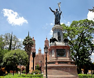
Dolores Hidalgo is the name of a city and the surrounding municipality in the north-central part of the Mexican state of Guanajuato.
Coatepec Harinas is one of 125 municipalities in the State of Mexico, Mexico. The municipal seat is the town of Coatepec Harinas. The original name is "Coauhtepetl" which means 'serpent hill' in Náhuatl. Around 1825 because of a boom in flour production, the name "Harinas" was added.

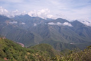
Badiraguato is a small city and seat of the Badiraguato Municipality in the Mexican state of Sinaloa. It stands at 25°21′47″N107°33′06″W. According to 2010 census, the city reported 3,725 inhabitants. The hamlet of La Tuna, located 110 kilometres to the North of the city, is the birthplace of Joaquín "El Chapo" Guzmán, for a long time one of Mexico's most powerful drug lords.

The municipality and town of Jamay is located in the eastern portion of Jalisco, Mexico, at coordinates 20°17.4′N102°42.6′W, at a height of 1,530 meters (5,020 ft) above sea level. The municipality extends from 20° 25' to 20° 13' N, and from 102° 38' to 102° 44' W.

Atoyac Municipality is a municipality in the Mexican state of Jalisco. The administrative centre for the municipality is located in the town of Atoyac, Jalisco.

Ojuelos de Jalisco is a town and municipality in the state of Jalisco, Mexico. The town's 1990 population was 7,265, although by the year 2010 it had increased to 11,881.
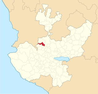
Granados is the municipal seat of Granados Municipality in the northeast of the Mexican state of Sonora. The municipal area is 361.27 km2, and the population was 1,228 according to the 2000 census. By 2005 the population had decreased to 938 due to emigration due to insufficient educational infrastructure and the lack of job opportunities.

Chicoasén is a town and municipality in the Mexican state of Chiapas in southern Mexico. It covers an area of 82 km².

Salto de Agua is a town and municipality in the Mexican state of Chiapas in southern Mexico.
Pánuco is a city in the Mexican state of Veracruz, located in the state's Huasteca Alta region. It serves as the municipal seat of the surrounding Pánuco Municipality. It stands on the banks of the Río Pánuco.

Atotonilco El Alto is a town and municipality, in Jalisco in Los Altos (Jalisco) region in central-western Mexico. The municipality covers an area of 510.9 km2.

Cuautitlán de García Barragán is a town and municipality in Jalisco in central-western Mexico. The municipality covers an area of 1,391 km².
Hostotipaquillo is a town and municipality, in Jalisco in central-western Mexico. The municipality covers an area of 756.4 km².
Magdalena is a town and municipality in the state of Jalisco in central-western Mexico. Magdalena lies 78 kilometers northwest of Guadalajara. The municipality covers an area of 293.2 km2. It borders the state of Nayarit to the west, and the town of Tequila to the east. As of 2005, the municipality had a total population of 18,924.

Mascota is a town and municipality in Jalisco, in central-western Mexico. The municipality covers an area of 1,843 km2. The name Mascota comes from the root "Amaxacotlán", which means "place of deer and colubrids".

Tuxcueca is a town and municipality, in Jalisco in central-western Mexico. The municipality covers an area of 132.4 km².
Ángel R. Cabada is a town (villa) in the Mexican state of Veracruz. Located in the state's Papaloapan River region, it serves as the municipal seat for the surrounding municipality of the same name.
San Francisco Telixtlahuaca is a town and municipality in Oaxaca in south-western Mexico. The municipality covers an area of 79.1 km². It is part of the Etla District in the Valles Centrales region.
Santiago Astata is a town and municipality in Oaxaca in south-western Mexico. It is part of the Tehuantepec District in the west of the Istmo Region. The name "Astata" means "place of herons".
Totutla is a municipality located in the south zone in the Mexican state of Veracruz, about 40 km from the state capital Xalapa. It has an area of 80.61 km2. It is located at 19°13′N96°58′W. The name comes from the language Náhuatl, Toto-tlan; that means “Among the birds".


