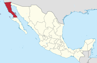
Baja California is a state in Northwest Mexico that is divided into seven municipalities. According to the 2020 Mexican Census, Baja California is the 13th most populous state with 3,769,020 inhabitants and the 12th largest by land area spanning 73,290.08 square kilometres (28,297.46 sq mi).

Chiapas is a state in Southwest Mexico. According to the 2020 Mexican Census, it has the eighth largest population of all states with 5,543,828 inhabitants and the 10th largest by land area spanning 73,560.47 square kilometres (28,401.86 sq mi). Chiapas is officially divided into 124 municipalities, although the establishment of municipal authorities in Belisario Domínguez was suspended in 2015 pending the resolution of a territorial dispute between Chiapas and the neighbouring state of Oaxaca. In 2021, the Mexican Supreme Court resolved this dispute in Oaxaca's favour, and annulled the 2011 decree that had created Belisario Domínguez.

Asientos is a municipality in the Mexican state of Aguascalientes. It stands at 22°14′N102°05′W. The town of Real de Asientos serves as the municipal seat for the surrounding municipality of Asientos.

Lagos de Moreno is a city and municipality in the State of Jalisco, Mexico. Lagos is located in the region of Los Altos de Jalisco, within the macroregion of the Bajío, one of the most highly developed areas in Latin America. Lagos de Moreno is occasionally known as the "Athens of Jalisco", owing to the numerous writers and poets who were born there.

Municipalities are the second-level administrative divisions of Mexico, where the first-level administrative division is the state. They should not be confused with cities or towns that may share the same name as they are distinct entities and do not share geographical boundaries. As of January 2021, there are 2,454 municipalities in Mexico, excluding the 16 boroughs of Mexico City.
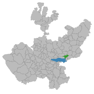
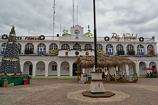
Ocotlán is a city and municipality in Jalisco, Mexico. Its industry includes furniture production. Is the seat of the Región Ciénega.
Ocosingo is a city and its surrounding municipality (municipio) of the same name in the Mexican state of Chiapas.
San Jerónimo is a locality and municipal agency of San Martín de Hidalgo Municipality, Jalisco, Mexico. As of the 2010 census, the village had a total population of 355, making it the eleventh-largest locality in the municipality and the second-largest in the territorial sub-committee.

Mapastepec is a town and municipality in the southeastern state of Chiapas, Mexico. Its name derives from the place name mapachtepec, "Hill of the Raccoon", a compound of the Nahuatl words mapachi ("raccoon") and tepetl ("mountain").
Lafragua Municipality is a municipality in the Mexican state of Puebla. According to the National Statistics Institute (INEGI), it had a population of 10,551 inhabitants in the 2005 census. By the 2010 census it had dropped to 7,767 inhabitants, 761 of whom lived in Saltillo, the municipal seat. Its total area is 128.85 km². The Saltillo name comes from the Nahuatl words Atlcholoa in atl, which means water, and Choloa, meaning drip. Therefore, means water that drips. The name Lafragua is in honor of José María Lafragua.

Cosio is a municipality and town in the Mexican state of Aguascalientes. It stands at 22°22′N102°18′W. The municipal seat is the town of Cosío. As of 2010, the town of Cosío had a population of 4,898.
Las Minas is a municipality in the Mexican state of Veracruz, located 28 kilometres (17 mi) northeast of the state capital Xalapa.
Honduras de la Sierra is a municipality in the Mexican state of Chiapas, located approximately 150 kilometres (93 mi) southeast of the state capital of Tuxtla Gutiérrez. Gazetted in 2019, it is the newest municipality in Chiapas.
Capitán Luis Ángel Vidal is a municipality in the Mexican state of Chiapas, located approximately 138 kilometres (86 mi) southeast of the state capital of Tuxtla Gutiérrez. Its inhabitants are of Guatemalan origin and speak the Mam language.
Rincón Chamula San Pedro is a municipality in the Mexican state of Chiapas, located approximately 54 kilometres (34 mi) north of the state capital of Tuxtla Gutiérrez. Unlike the mestizo population of the surrounding towns, its population is mostly indigenous Tzotzil.
Mezcalapa is a municipality in the Mexican state of Chiapas, located approximately 71 kilometres (44 mi) northwest of the state capital of Tuxtla Gutiérrez. Its municipal seat is Raudales Malpaso.
El Parral is a municipality in the Mexican state of Chiapas, located approximately 45 kilometres (28 mi) south of the state capital of Tuxtla Gutiérrez.
Emiliano Zapata is a municipality in the Mexican state of Chiapas, located approximately 33 kilometres (21 mi) southeast of the state capital of Tuxtla Gutiérrez.

Jiménez is a municipality in the Mexican state of Michoacán, located approximately 65 kilometres (40 mi) west of the state capital of Morelia.

Miguel Auza is a municipality in the Mexican state of Zacatecas, located approximately 190 kilometres (120 mi) northwest of the state capital of Zacatecas City.


